Over 40% of global carbon emissions are linked to the built environment — and yet, until recently, the tools used to assess buildings and land rarely captured ecological data at all. That gap is closing fast. Sustainability-Driven Surveying: Using Tech to Assess Environmental Impacts has moved from a niche concept to a regulatory necessity, particularly as 2026 brings stricter environmental compliance requirements across the UK and beyond.
Whether you are a property developer, a building owner, or a chartered surveyor, understanding how modern technology now captures ecological data — and how that data shapes planning decisions — is no longer optional. It is fundamental to responsible development.
Key Takeaways 📋
- New surveying technologies — including drones, LiDAR, thermal imaging, and AI-powered platforms — now capture detailed ecological data that traditional surveys could not.
- Sustainability-driven surveying helps forecast environmental impacts before construction begins, reducing costly surprises and regulatory delays.
- 2026 regulatory changes in the UK require more rigorous environmental impact assessments (EIAs), making tech-enabled surveys a compliance tool, not just a best practice.
- Soil, water, and air quality data collected during surveys directly inform green development strategies and biodiversity net gain calculations.
- Chartered surveyors who integrate environmental tech into their practice provide significantly higher value to clients navigating planning and sustainability obligations.
How Technology Is Transforming Sustainability-Driven Surveying
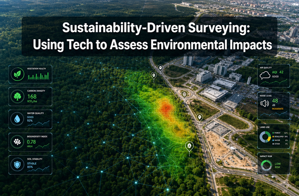
The phrase Sustainability-Driven Surveying: Using Tech to Assess Environmental Impacts describes a practice that blends traditional survey methodology with cutting-edge environmental data collection. The result is a richer, more actionable picture of how a site interacts with its surrounding ecosystem.
Drones and Aerial Imaging 🚁
Drone surveys have become one of the most powerful tools in the sustainability surveyor's kit. A drone equipped with multispectral or thermal cameras can map vegetation health, identify water drainage patterns, and detect heat loss from structures — all in a single flight.
Key benefits of drone-based ecological surveying:
| Capability | Environmental Application |
|---|---|
| Multispectral imaging | Vegetation health and biodiversity mapping |
| Thermal imaging | Heat loss detection, urban heat island analysis |
| LiDAR scanning | Topographic mapping, flood risk modelling |
| Photogrammetry | 3D site models for impact simulation |
| RGB photography | Land-use change documentation |
Drones reduce the need for invasive ground-level surveys, which itself lowers the carbon footprint of the assessment process. They also reach areas — steep slopes, wetlands, rooftops — that would otherwise require scaffolding or specialist access equipment.
LiDAR and Ground-Penetrating Radar
LiDAR (Light Detection and Ranging) fires laser pulses at a surface and measures the return time to build precise 3D models. When applied to land surveying, it can reveal subtle topographic features that affect drainage, erosion risk, and habitat connectivity — none of which are visible to the naked eye.
Ground-penetrating radar (GPR) complements LiDAR by scanning beneath the soil surface. This is particularly useful for detecting buried contamination, underground water courses, and archaeological features that must be protected under planning law.
💬 "The shift from clipboard-and-camera surveys to sensor-rich, data-driven assessments is not just a technological upgrade — it is a fundamental change in what surveyors can promise their clients."
Remote Sensing and Satellite Data
Satellite imagery platforms now provide historical land-use data going back decades. Surveyors can overlay current site conditions against historical baselines to demonstrate ecological change, identify previously contaminated zones, or model how a proposed development might alter local hydrology.
This kind of longitudinal data is increasingly required by local planning authorities (LPAs) as part of Biodiversity Net Gain (BNG) assessments — a mandatory requirement under the Environment Act that became fully enforced for most developments in 2024 and continues to tighten through 2026.
Key Environmental Data Captured Through Tech-Enabled Surveys
Sustainability-Driven Surveying: Using Tech to Assess Environmental Impacts is not just about flying drones or running software. It is about capturing specific categories of environmental data that feed directly into planning applications, environmental impact assessments, and green development strategies.
🌱 Biodiversity and Habitat Data
Modern ecological surveys use AI-assisted species identification tools — including acoustic monitoring for bats and birds — to produce habitat maps that meet the DEFRA Biodiversity Metric 4.0 standard. This metric calculates a site's biodiversity value before and after development, ensuring a net gain of at least 10% is achieved.
Monitoring surveys play a critical role here. Ongoing ecological monitoring — not just a one-off assessment — is now expected by many LPAs, particularly for larger developments near sensitive habitats.
💧 Soil and Water Contamination
Contaminated land is one of the most significant environmental liabilities a property can carry. Tech-enabled surveys now use portable X-ray fluorescence (XRF) analysers, electrochemical sensors, and laboratory-linked field kits to detect heavy metals, hydrocarbons, and other pollutants in soil and groundwater.
Assessing soil and water contamination early in the development process prevents costly remediation surprises later — and demonstrates due diligence to both regulators and lenders.
🌊 Drainage and Flood Risk
Sustainable urban drainage systems (SuDS) are now a planning requirement for most new developments. Accurate drainage modelling depends on precise topographic data — exactly what LiDAR and drone surveys provide.
A thorough drainage survey identifies existing drainage infrastructure, assesses its capacity, and models how development will alter surface water runoff. This data directly informs SuDS design and helps developers meet Environment Agency requirements.
☀️ Energy Performance and Carbon Footprint
Thermal imaging surveys of existing buildings reveal heat loss patterns that standard visual inspections miss entirely. Combined with energy modelling software, this data produces accurate baseline carbon assessments — essential for retrofit projects targeting EPC Band C or above, which is increasingly required for rental properties under evolving UK legislation.
For solar installations, structural engineers now use specialist calculations to assess whether a roof can support panels — see how engineer calculations for solar panel roofs support green energy retrofits.
Regulatory Compliance in 2026: What Developers and Surveyors Must Know
The regulatory landscape for environmental assessment has tightened considerably. Sustainability-Driven Surveying: Using Tech to Assess Environmental Impacts is no longer just good practice — in many cases, it is a legal requirement.
Key 2026 Regulatory Drivers 📜
1. Biodiversity Net Gain (BNG)
All major planning applications in England must now demonstrate a minimum 10% BNG using the DEFRA metric. This requires baseline ecological surveys and post-development monitoring commitments — both of which depend on tech-enabled data collection.
2. Environment Act Requirements
The Environment Act introduced legally binding targets for air quality, water quality, biodiversity, and waste reduction. Developments that cannot demonstrate compliance risk planning refusal or enforcement action.
3. Future Homes Standard
New residential buildings must meet significantly higher energy efficiency standards. Surveyors assessing existing properties for retrofit or redevelopment need accurate baseline energy data — thermal imaging and air permeability testing are now standard tools.
4. Environmental Impact Assessment (EIA) Regulations
EIA thresholds remain in place, but the quality of data expected within EIA reports has risen sharply. Regulators increasingly expect GIS-mapped data, drone imagery, and sensor-derived measurements rather than desk-based assessments alone.
Practical Compliance Tips for 2026 ✅
- Commission ecological surveys early — ideally before purchasing a site — to avoid late-stage planning delays.
- Use accredited surveyors who understand both the technical tools and the regulatory frameworks they feed into.
- Document everything digitally — LPAs and the Environment Agency increasingly expect GIS-compatible data files, not just PDF reports.
- Build monitoring into project timelines — BNG obligations extend for 30 years post-development, requiring ongoing ecological monitoring agreements.
- Integrate sustainability data into dilapidations assessments — for commercial properties, dilapidation surveys that account for energy performance and environmental condition are becoming the norm.
Integrating Sustainability Data Into Standard Survey Practice
One of the most significant shifts in 2026 is the expectation that environmental considerations are embedded into standard surveys — not treated as a separate, specialist add-on.
Building Surveys and Environmental Checks 🏠
A comprehensive building survey now routinely includes observations about insulation quality, evidence of damp linked to ventilation failure, roof condition relevant to solar potential, and drainage performance. These observations, when combined with tech-generated data, give clients a complete picture of a property's environmental liabilities and opportunities.
For buyers considering older or non-standard properties, understanding the environmental baseline is just as important as understanding structural condition. A specific defect report can isolate and assess individual environmental concerns — such as asbestos risk, damp caused by poor drainage, or roof deterioration affecting energy performance.
Stock Condition Surveys for Housing Providers
Social landlords and housing associations face particular pressure to meet energy efficiency and environmental standards across large property portfolios. A stock condition survey that integrates thermal imaging and energy performance data allows housing providers to prioritise retrofit investment, model carbon reduction trajectories, and demonstrate compliance with Decent Homes standards.
Subsidence and Ground Movement Monitoring
Climate change is increasing the frequency of ground movement events linked to drought, flooding, and soil shrinkage. Subsidence surveys now use precision monitoring equipment — including inclinometers, settlement gauges, and satellite-based InSAR (Interferometric Synthetic Aperture Radar) — to track ground movement over time and assess environmental causation.
This data is invaluable for insurance purposes, planning decisions, and understanding how a changing climate is affecting the built environment at a site-specific level.
The Business Case for Sustainability-Driven Surveying
Beyond compliance, there is a compelling commercial argument for embracing tech-enabled environmental assessment.
Properties with strong environmental credentials command measurable premiums:
- 🏡 Homes with EPC ratings of A or B sell for up to 14% more than equivalent F or G-rated properties (based on UK Land Registry and energy data analysis).
- 🏢 Commercial properties meeting BREEAM Excellent or Outstanding standards attract lower-risk tenants and better financing terms.
- 🌍 Developers who can demonstrate robust environmental data in planning applications face fewer objections and faster approvals.
For surveyors, offering sustainability-integrated services is also a significant differentiator in an increasingly competitive market. Clients — particularly institutional investors, housing associations, and forward-thinking developers — actively seek professionals who can bridge the gap between traditional survey expertise and environmental data science.
Conclusion: Actionable Next Steps for Greener Surveying
The convergence of environmental science and surveying technology is reshaping what it means to assess a property or a site in 2026. Sustainability-Driven Surveying: Using Tech to Assess Environmental Impacts is not a future trend — it is the current standard that regulators, planners, and informed clients now expect.
What to do next:
- Audit your current survey process — identify where environmental data collection is absent or insufficient, particularly around drainage, energy performance, and biodiversity.
- Invest in or commission tech-enabled tools — drones, thermal cameras, and GIS software are now accessible at price points that make commercial sense for most survey practices.
- Understand the 2026 regulatory requirements that apply to your specific project type — BNG, EIA, Future Homes Standard, and EPC obligations each carry different data requirements.
- Partner with chartered surveyors who have demonstrable experience integrating environmental technology into their assessments. Explore the full range of survey services available to find the right fit for your project.
- Plan for long-term monitoring — sustainability is not a one-time assessment. Build ecological and energy monitoring into project timelines from day one.
The built environment's relationship with the natural world is under unprecedented scrutiny. The surveyors and developers who thrive in this environment will be those who treat ecological data not as a compliance burden, but as a strategic asset.