By 2026, the global geospatial and surveying market is projected to surpass $14 billion, driven almost entirely by the rapid adoption of digital tools that would have seemed futuristic just a decade ago. The profession is not simply evolving — it is being fundamentally rebuilt from the ground up. Understanding the Six Key Surveying Trends for 2026: Accelerating Digital Transformation is now essential for any surveyor, property professional, or construction stakeholder who wants to remain competitive, accurate, and efficient in a landscape that rewards speed and precision above all else.
From GNSS RTK systems delivering centimetre-level accuracy in real time, to AI-assisted reporting tools that cut turnaround times dramatically, the shift is already underway. This article breaks down each major trend, explains why it matters, and offers practical tips for surveyors ready to adapt.
Key Takeaways 📌
- Real-time data processing is replacing traditional batch workflows, enabling faster, more accurate survey outputs.
- GNSS RTK technology now delivers sub-centimetre accuracy, transforming boundary, structural, and topographic surveys.
- Cloud platforms are centralising data management and enabling seamless collaboration across project teams.
- Drone-based LiDAR and photogrammetry are reducing site visit time while increasing data richness.
- AI and automation are streamlining report generation, defect identification, and compliance checking.
- Surveyors who invest in upskilling and digital integration now will hold a significant competitive advantage through 2026 and beyond.
Trend 1: Real-Time Data Processing Transforms Survey Workflows
One of the most significant shifts in the Six Key Surveying Trends for 2026: Accelerating Digital Transformation is the move from delayed, batch-processed data to real-time data processing. Historically, surveyors collected measurements in the field and returned to the office to process results — a workflow that introduced delays, errors, and communication gaps.
In 2026, real-time processing means that data captured on-site is instantly analysed, validated, and shared with project stakeholders. This is made possible by:
- Edge computing devices embedded in survey equipment
- 5G connectivity enabling high-bandwidth data transfer from remote locations
- Cloud-integrated field software that syncs automatically with back-office systems
💬 "The ability to process and validate data in the field — rather than days later in the office — is arguably the single biggest productivity gain the profession has seen in a generation."
Why it matters for surveyors: Errors can be caught and corrected on-site, reducing costly return visits. Clients receive preliminary findings faster, improving satisfaction and trust. For complex projects such as structural surveys or drainage surveys, real-time validation ensures that no critical data point is missed before the team leaves the site.
Practical Tips for Adapting to Real-Time Processing
✅ Invest in field-ready tablets and software that sync with cloud platforms
✅ Train field teams to interpret live data outputs, not just collect raw measurements
✅ Establish standardised data validation protocols that can be applied on-site
✅ Use real-time dashboards to share progress with clients and project managers
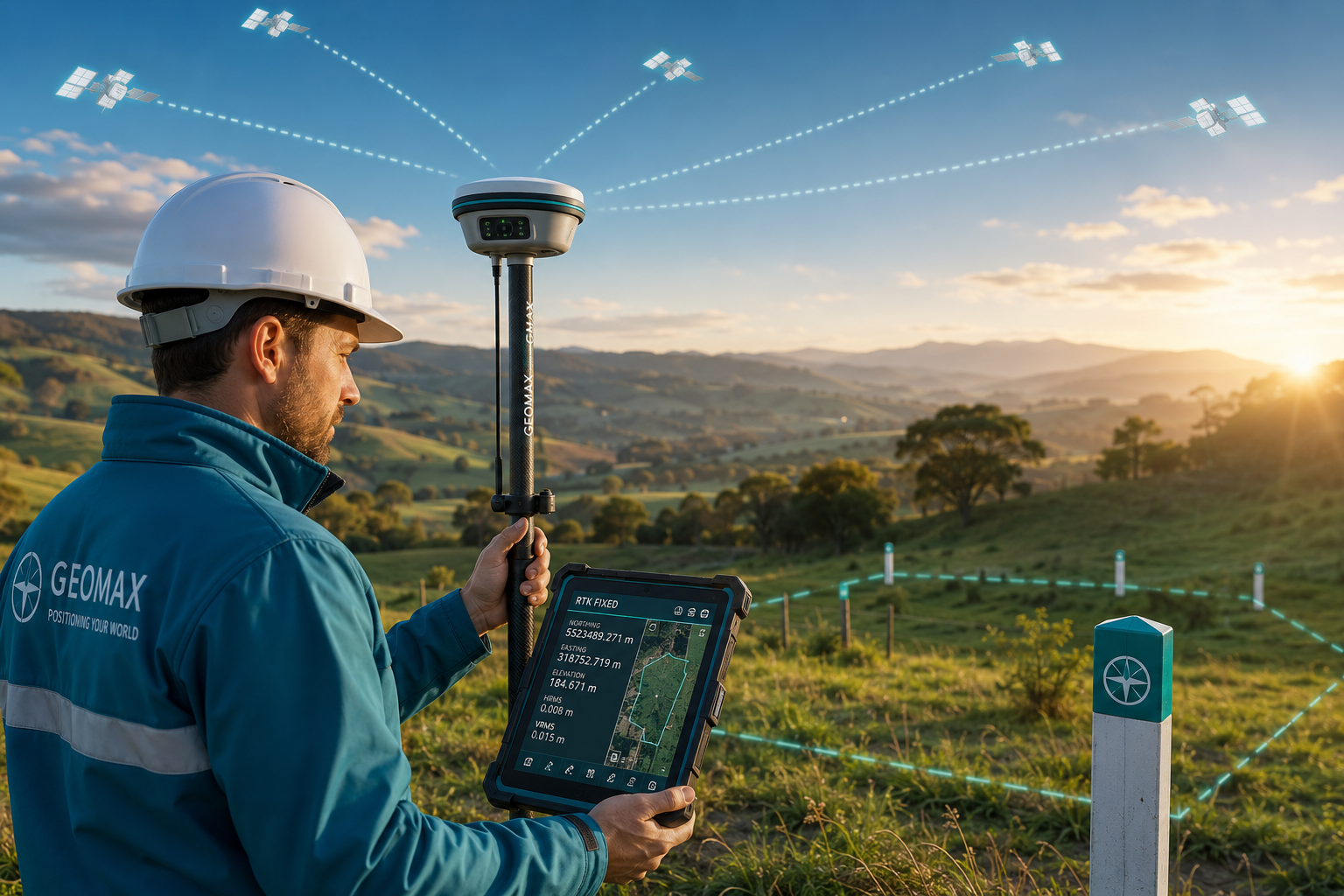
Trend 2: GNSS RTK Technology Delivers Unprecedented Accuracy
Global Navigation Satellite System Real-Time Kinematic (GNSS RTK) positioning has matured into one of the most transformative tools available to modern surveyors. Where traditional GPS offered accuracy within several metres, GNSS RTK now routinely achieves sub-centimetre precision — even in challenging environments.
| Technology | Typical Accuracy | Best Use Case |
|---|---|---|
| Standard GPS | 3–5 metres | General navigation |
| DGNPS | 0.5–1 metre | Basic mapping |
| GNSS RTK | 1–2 centimetres | Boundary, topographic, construction surveys |
| Network RTK (NRTK) | 1–3 centimetres | Wide-area precision surveys |
This level of accuracy has profound implications for boundary surveys, where even small positional errors can result in costly legal disputes. It also enhances the reliability of building surveys where precise measurements underpin structural assessments and planning applications.
Key advantages of GNSS RTK in 2026:
- 🎯 Centimetre-level accuracy without the need for physical base stations in many networks
- ⚡ Faster setup and data collection compared to traditional total station workflows
- 📡 Integration with correction networks (such as OS Net in the UK) for reliable nationwide coverage
- 🔗 Seamless data export to BIM, CAD, and GIS platforms
Network RTK and the Rise of Continuously Operating Reference Stations (CORS)
The expansion of Continuously Operating Reference Station (CORS) networks across the UK and globally means surveyors can access RTK corrections via mobile data without deploying their own base stations. This reduces equipment costs and setup time significantly — a major benefit for smaller practices and sole practitioners.
Tip for surveyors: When selecting GNSS RTK equipment, prioritise compatibility with national CORS networks and ensure the receiver supports multiple constellations (GPS, GLONASS, Galileo, BeiDou) for maximum reliability in urban and obstructed environments.

Trend 3: Drone-Based LiDAR and Photogrammetry Scale New Heights
Unmanned Aerial Vehicles (UAVs) equipped with LiDAR sensors and photogrammetric cameras have moved from experimental technology to mainstream surveying tools. In 2026, drone surveys are being used across a wide range of applications — from large-scale topographic mapping to detailed roof surveys on residential and commercial properties.
LiDAR vs. Photogrammetry: A Quick Comparison
| Feature | LiDAR | Photogrammetry |
|---|---|---|
| Works in low light | ✅ Yes | ❌ No |
| Penetrates vegetation | ✅ Yes | ❌ Limited |
| Cost | Higher | Lower |
| Output | 3D point cloud | Orthomosaic / 3D mesh |
| Best for | Dense terrain, forestry, infrastructure | Open sites, buildings, visualisation |
The combination of both technologies — often deployed together on a single drone platform — gives surveyors a richly detailed, georeferenced dataset that can be processed into accurate 3D models within hours.
Regulatory context in the UK (2026): The Civil Aviation Authority (CAA) continues to refine its drone operating regulations. Surveyors must hold appropriate operational authorisation and ensure compliance with airspace restrictions, particularly in urban areas. Staying current with CAA guidance is a non-negotiable professional responsibility.
Practical Drone Survey Tips for 2026
- 📋 Always conduct a pre-flight risk assessment and site reconnaissance
- 🗺️ Use ground control points (GCPs) to enhance absolute accuracy
- 💾 Plan data storage and processing workflows before the flight
- 🔒 Ensure data privacy compliance, particularly when surveying near residential properties
Trend 4: Cloud Platforms Enable Seamless Collaboration
The fourth pillar of the Six Key Surveying Trends for 2026: Accelerating Digital Transformation is the widespread adoption of cloud-based project management and data platforms. These systems are dissolving the traditional barriers between field teams, office staff, clients, and third-party consultants.
Cloud platforms used in surveying typically offer:
- Centralised data storage accessible from any device, anywhere
- Version control ensuring all stakeholders work from the latest dataset
- Automated workflows that trigger actions (such as report generation or client notifications) when data milestones are reached
- Integration APIs connecting survey software with BIM, CAD, accounting, and project management tools
For practices handling complex instructions — such as commercial building surveys or dilapidations surveys — cloud platforms dramatically reduce the risk of miscommunication and data loss across large project teams.
💬 "Cloud adoption in surveying is not just a technology upgrade — it is a fundamental change in how practices deliver value to their clients."
Security considerations: As more sensitive property and financial data moves to the cloud, practices must implement robust cybersecurity measures. This includes multi-factor authentication, encrypted data transfer, and regular security audits. GDPR compliance remains a legal obligation for all UK-based practices handling client data.
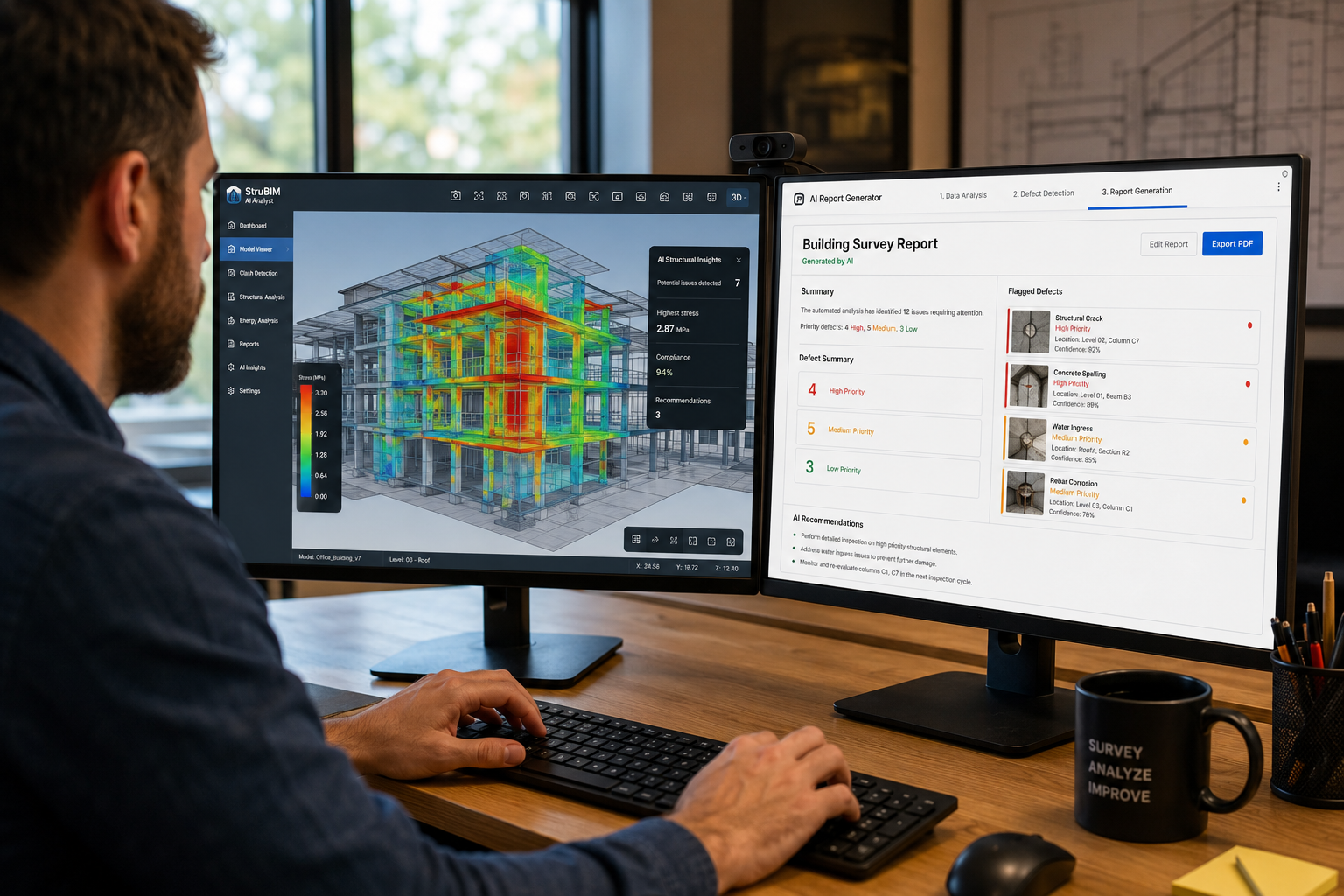
Trend 5: AI and Automation Reshape Reporting and Defect Detection
Artificial Intelligence is making measurable inroads into the surveying profession — not to replace surveyors, but to augment their capabilities and free them from repetitive, time-consuming tasks.
Key AI applications in surveying (2026):
| Application | Benefit |
|---|---|
| Automated defect detection from imagery | Faster, more consistent identification of cracks, damp, and structural issues |
| AI-assisted report generation | Reduces report writing time by up to 40% |
| Predictive maintenance modelling | Helps clients plan future maintenance budgets |
| Natural language processing for compliance checking | Flags regulatory issues automatically |
For example, AI image analysis tools can scan hundreds of photographs taken during a structural survey and automatically flag potential defects — categorising them by severity and location. This does not replace the surveyor's professional judgement, but it does ensure that nothing is overlooked and that reporting is consistent across a practice.
Similarly, AI tools are being applied to specific defect reports, helping surveyors produce detailed, client-ready documentation more efficiently than ever before.
Upskilling for an AI-Augmented Profession
Surveyors who want to stay ahead should:
✅ Familiarise themselves with AI-assisted survey software platforms
✅ Understand the limitations of AI outputs — professional oversight remains critical
✅ Engage with RICS guidance on the ethical use of AI in professional practice
✅ Invest in continuing professional development (CPD) focused on digital tools
Trend 6: BIM Integration and Digital Twins Redefine Asset Management
Building Information Modelling (BIM) and its logical evolution — the digital twin — represent the most ambitious frontier in surveying's digital transformation. A digital twin is a live, data-rich virtual replica of a physical asset, updated continuously with real-world sensor data.
By 2026, BIM Level 2 is the baseline expectation on most UK public sector projects, and many private sector clients are now demanding the same. Surveyors who can contribute to and interrogate BIM models are significantly more valuable to multidisciplinary project teams.
How digital twins benefit property professionals:
- 🏗️ Construction phase: Real-time monitoring of build progress against design intent
- 🏢 Occupation phase: Ongoing tracking of structural performance, energy use, and maintenance needs
- 🔄 Refurbishment: Accurate existing conditions data to inform design decisions
- 📊 Valuation: Richer asset data supporting more accurate property valuations
The integration of survey data into BIM environments requires surveyors to develop new competencies — including familiarity with IFC file formats, model coordination software, and data standards such as COBie.
For practices managing party wall matters, BIM and digital documentation tools are also improving the quality and defensibility of schedules of condition — providing timestamped, georeferenced photographic records that protect all parties in the event of a dispute.
The Road to Digital Twin Adoption
| Stage | Description | Typical Timeline |
|---|---|---|
| BIM Level 2 | Collaborative 3D modelling with shared data environment | Now standard (2026) |
| Asset Information Model | Structured data handover at project completion | Increasingly required |
| Digital Twin (Basic) | Static model updated periodically with survey data | Growing adoption |
| Digital Twin (Live) | Continuously updated via IoT sensors and survey inputs | Emerging in major assets |
How Surveyors Can Adapt: A Practical Roadmap for 2026
Understanding the Six Key Surveying Trends for 2026: Accelerating Digital Transformation is only valuable if it translates into action. Here is a concise roadmap for practices at any stage of their digital journey:
🔵 Foundations (Start Here)
- Audit current technology stack and identify gaps
- Invest in cloud-based project management software
- Ensure all team members have basic digital literacy training
🟡 Intermediate Steps
- Adopt GNSS RTK equipment compatible with national correction networks
- Integrate drone surveys into relevant service lines (roofs, topographic, large sites)
- Implement AI-assisted reporting tools and establish quality control protocols
🟢 Advanced Integration
- Develop BIM competency and offer digital twin consultancy
- Build API integrations between field software, office systems, and client portals
- Establish a data governance framework covering security, privacy, and retention
💡 Pro Tip: Digital transformation does not require replacing everything at once. The most successful practices in 2026 are those that have taken a phased, strategic approach — building capability incrementally while maintaining service quality throughout the transition.
Conclusion: Act Now to Lead in 2026
The Six Key Surveying Trends for 2026: Accelerating Digital Transformation — real-time data processing, GNSS RTK precision, drone-based LiDAR, cloud collaboration, AI-assisted reporting, and BIM/digital twin integration — are not distant possibilities. They are active forces reshaping the profession right now.
Surveyors and practices that embrace these changes will deliver faster results, fewer errors, richer datasets, and more compelling client experiences. Those who delay risk falling behind in a market where clients increasingly expect digital-first service delivery.
Actionable next steps:
- Assess your current digital capabilities honestly against the six trends outlined above
- Prioritise one or two areas for immediate investment based on your service mix and client base
- Train your team — technical skills and professional judgement must evolve together
- Engage with RICS digital transformation resources and industry working groups
- Partner with technology providers who understand the specific demands of the surveying profession
Whether the focus is on local chartered surveying services or large-scale commercial instructions, the digital tools available in 2026 make it possible to deliver a higher standard of service than ever before. The question is not whether to transform — it is how quickly and how strategically to do so.