Survey firms that still email static PDF reports are losing contracts to competitors who deliver live, browser-based 3D models that clients can annotate from a smartphone before the surveyor has even left the site. That gap — between legacy document delivery and genuine real-time collaboration — is now the defining competitive divide in the property surveying industry in 2026. Cloud-based platforms: enabling real-time collaboration in property surveys is no longer a niche capability; it is rapidly becoming the baseline expectation for every stakeholder in a property transaction or development project. [1]
Key Takeaways 📋
- Cloud platforms have replaced static PDFs as the standard survey deliverable, giving all stakeholders access to live, synchronized data from any device.
- Real-time 3D visualization via browser-based tools means architects, engineers, and clients can review survey models without specialist desktop software.
- Instant revision syncing eliminates version-control errors and reduces costly rework across multi-disciplinary teams.
- Remote access and live field-to-office data streaming compress project timelines and improve decision-making speed.
- BIM integration through the cloud is creating new demand for surveyors who can feed geospatial data directly into shared design models.
Why the Industry Shifted: From Static Reports to Live Shared Workspaces
For decades, a completed property survey meant a bound report dropped through a letterbox or a PDF attached to an email. The document was accurate at the moment of capture — and immediately began aging. By the time an architect, structural engineer, and planning consultant had each reviewed their copy, marked it up independently, and replied, days had passed and the risk of someone working from a superseded version was very real.
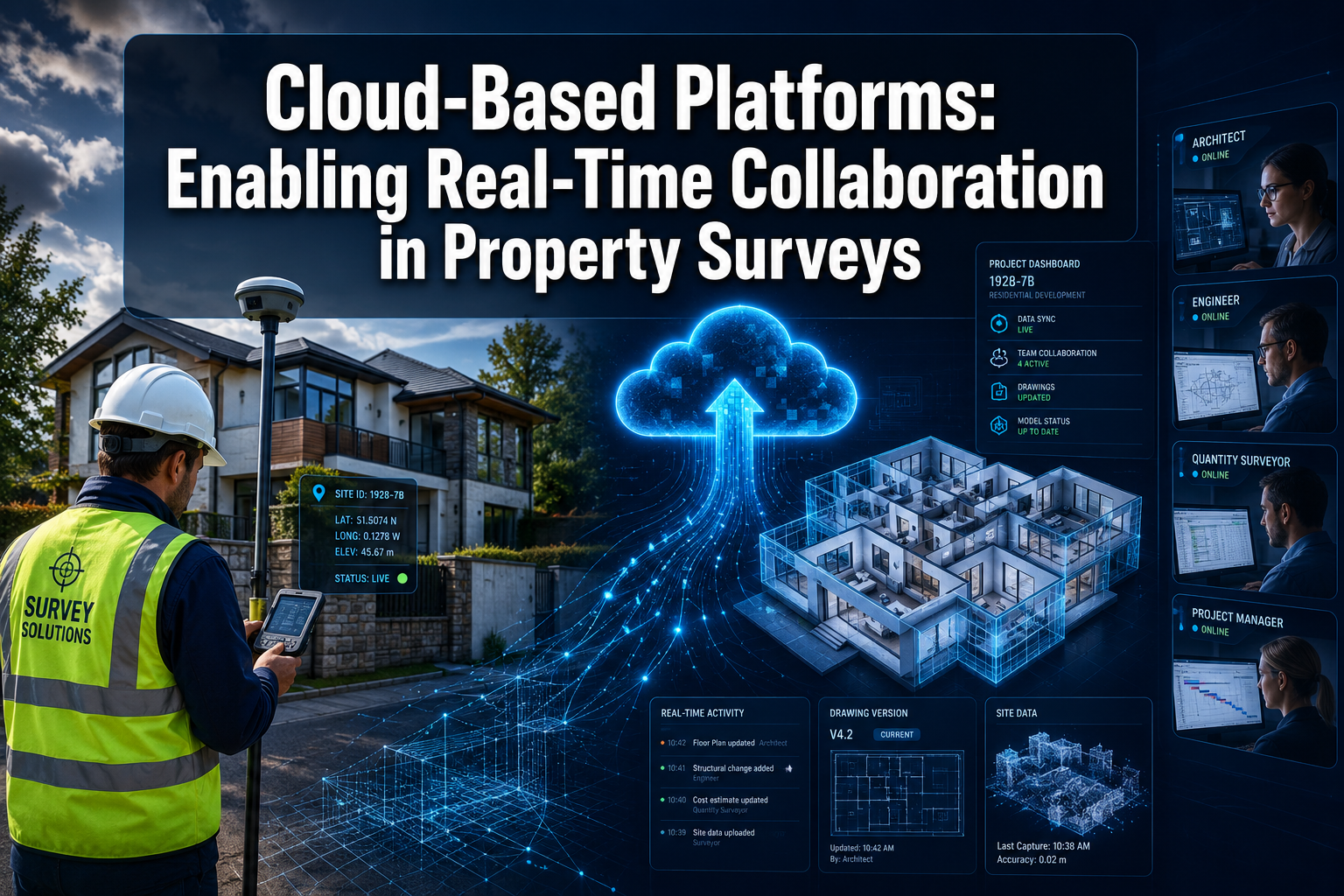
Cloud-based platforms fundamentally broke that model. Survey data captured in the field — whether from a GNSS rover, a laser scanner, or a drone — is now streamed directly into a cloud environment where it is processed, visualized, and made available to every authorized stakeholder simultaneously. [2] There is no end-of-day upload, no emailed attachment, and no ambiguity about which version is current.
"The shift is not just technological — it is cultural. Clients now expect to log in and see their survey progressing in real time, not wait for a finished document." [5]
This expectation is reshaping every survey type, from a straightforward homebuyer survey to a complex commercial building survey involving dozens of stakeholders across multiple disciplines.
The Core Problem Cloud Platforms Solve
| Legacy Workflow Pain Point | Cloud Platform Solution |
|---|---|
| Multiple PDF versions in circulation | Single source of truth, version-controlled |
| Slow email chains for queries | Integrated commenting and task assignment |
| Desktop software required to view 3D data | Browser-based 3D visualization, any device |
| End-of-day batch uploads | Live field-to-cloud data streaming |
| Siloed discipline teams | Shared BIM/CAD environment for all parties |
| Client excluded until final report | Client portal with live progress visibility |
How Cloud-Based Platforms: Enabling Real-Time Collaboration in Property Surveys Actually Works
Understanding the mechanics helps surveyors, clients, and developers make better decisions about adopting these tools. The workflow typically has three interconnected layers.
1. Field Data Capture and Instant Upload 🛰️
Modern survey instruments — total stations, GNSS rovers, terrestrial laser scanners, and drone-mounted LiDAR units — now connect directly to cloud ecosystems via 4G/5G or Wi-Fi. [6] As a surveyor measures a boundary, records a structural defect, or captures a point cloud of a roof structure, that data is transmitted to the cloud in near real time. Office teams can monitor survey progress live, flag issues while the crew is still on site, and begin preliminary processing without waiting for the surveyor to return.
This is particularly valuable on large or complex projects — for example, a stock condition survey across a housing portfolio, where multiple survey teams working simultaneously need their data merged into one coherent dataset without manual file consolidation.
2. Browser-Based 3D Visualization 🖥️
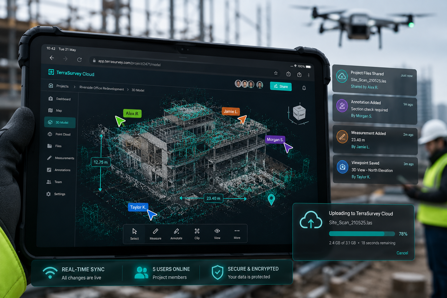
Once data reaches the cloud, processing pipelines — increasingly automated by AI — convert raw point clouds, photogrammetric outputs, and CAD drawings into interactive 3D models accessible through a standard web browser. [2] No specialist software installation is required. An architect in Edinburgh, a structural engineer in London, and a property developer in Dubai can all open the same model, zoom into the same corner of a building, and leave comments pinned to exact coordinates.
This capability is transforming how building surveys are consumed. Rather than reading a written description of a crack in a party wall, a client can rotate a 3D model, view the associated photograph, read the surveyor's annotation, and see the recommended remedial action — all in one interface.
Key features of browser-based 3D visualization:
- 🔍 Measure distances and areas directly within the model
- 📌 Pin comments to specific locations in 3D space
- 📸 Link photographs to point cloud coordinates
- 🔄 Toggle between survey epochs to compare change over time
- 📱 Full functionality on tablets and smartphones
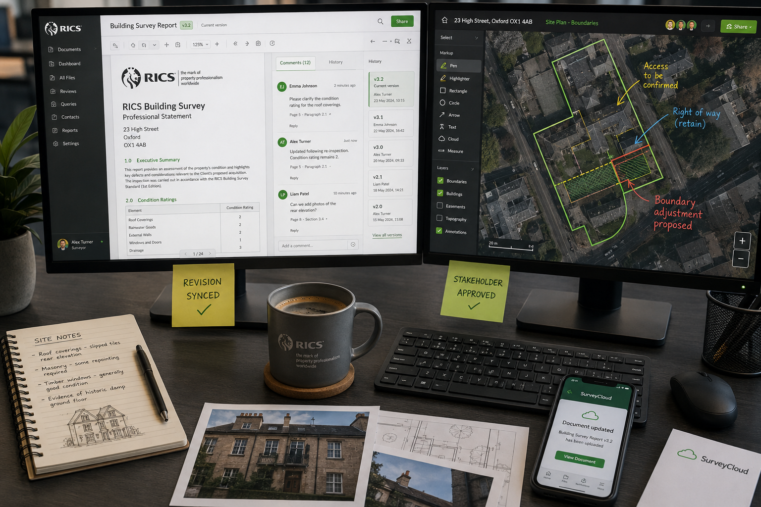
3. Revision Syncing and Version Control ✅
Perhaps the most underappreciated benefit of cloud-based collaboration is automatic revision syncing. When a surveyor updates a drawing, corrects a measurement, or adds a new defect annotation, every connected user sees the change immediately. Version history is logged automatically, so it is always possible to see who changed what and when.
This eliminates one of the most expensive problems in traditional survey workflows: teams working from different versions of the same document. On a high-precision project — such as surveying for a data centre development where floor-load tolerances are extremely tight — a single outdated drawing reaching the wrong team can trigger costly rework. [7] Cloud platforms make that scenario structurally impossible.
Benefits for Remote Access and Stakeholder Communication in 2026 Workflows

The practical benefits of cloud-based platforms: enabling real-time collaboration in property surveys extend well beyond the survey team itself. They reshape the entire stakeholder communication model.
Clients Get Unprecedented Transparency 👥
Property buyers, developers, and asset managers no longer need to wait for a finished report to understand what a survey has found. Client portals — a standard feature of leading cloud survey platforms — give non-technical users a simplified view of survey progress, key findings flagged in real time, and the ability to raise questions directly within the platform. This transparency builds trust and reduces the volume of chasing emails and phone calls that consume surveyor time.
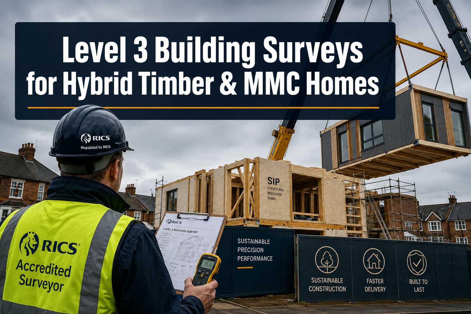
For a client commissioning an RICS Level 3 building survey on a complex older property, being able to see photographs and preliminary notes as the survey progresses — rather than waiting a week for the finished report — is a genuinely transformative experience.
Multi-Disciplinary Teams Coordinate Without Friction 🤝
The biggest efficiency gain from cloud collaboration comes when multiple professional disciplines work on the same project. BIM (Building Information Modeling) integration through the cloud is now a key driver of this coordination. [1] Surveyors supply geospatial data directly into a shared BIM model hosted on a cloud platform. Architects use that data to design. Structural engineers check their calculations against the as-built geometry. Contractors verify clearances before ordering materials.
The result: clash detection happens digitally, before anyone arrives on site with the wrong component. This is why cloud literacy is now explicitly listed as a competitive differentiator for survey firms bidding on modern property and infrastructure contracts. [8]
Boundary and Party Wall Disputes Become Easier to Resolve 📐
When all parties to a dispute — surveyors, solicitors, and property owners — can access the same georeferenced data through a cloud portal, the scope for misinterpretation shrinks dramatically. A boundary survey delivered through a cloud platform allows all parties to view the same measurements, overlaid on the same base mapping, with the same annotations. This shared visual reference can accelerate resolution and reduce the need for costly expert witness proceedings.
Geographic Barriers Disappear 🌍
Cloud-based workflows mean that a senior chartered surveyor can review, annotate, and sign off a survey conducted anywhere in the country without being physically present. This is especially relevant for specialist surveys — such as a roof survey requiring structural engineering input — where the relevant expert may be based far from the property. Remote access to live survey data makes that collaboration seamless.
Integrating Cloud Platforms with BIM, AI, and Drone Data
The power of cloud-based platforms: enabling real-time collaboration in property surveys multiplies when they serve as the integration hub for multiple data sources and technologies.
Drones and Mobile Mapping 🚁
UAV photogrammetry and drone-mounted LiDAR have become standard tools for large-scale property surveys. The data volumes involved — often tens of gigabytes per flight — make desktop processing impractical for collaborative workflows. Cloud processing engines handle the heavy computation, then expose the results as interactive 3D models through web dashboards. [2] Property developers, planners, and engineers can measure, comment, and request changes without any specialist software.
AI-Powered Automated Processing 🤖
Leading cloud platforms now incorporate AI to automate time-consuming processing steps: point cloud classification, defect detection in photographic records, and automated drafting of standard elements. [2] This reduces the time between field data capture and a usable deliverable from days to hours — or in some cases, minutes. Survey firms that have consolidated their workflows around cloud ecosystems report significant reductions in manual file handling and rework. [5]
Structural Engineering Collaboration 🏗️
For surveys that require structural engineering input — such as a residential structural survey or a solid floor slab survey — cloud platforms allow the surveyor and engineer to work within the same data environment. The engineer can view the surveyor's measurements, add their own calculations, and flag concerns directly within the shared model, rather than exchanging separate documents.
Practical Considerations for Adopting Cloud Survey Platforms
Adopting cloud-based collaboration tools requires more than purchasing a software subscription. Survey firms and their clients should consider the following:
🔐 Data Security and Compliance
Survey data — particularly for residential properties — contains sensitive personal and financial information. Cloud platforms must meet relevant data protection standards (UK GDPR in the UK context). Reputable platforms offer role-based access control, audit trails, and encrypted data storage.
📶 Connectivity in the Field
Real-time upload depends on reliable mobile connectivity. In rural or remote survey locations, this can be a limiting factor. Many platforms offer offline field capture with automatic sync when connectivity is restored.
🎓 Training and Adoption
The technology is only as effective as the people using it. Survey firms investing in cloud platforms should budget for staff training and allow time for workflow adaptation. Professional development resources now explicitly recommend cloud platform literacy as essential for surveyors to remain competitive. [8]
💰 Cost vs. Efficiency Gains
Cloud platform subscriptions represent an ongoing cost, but the efficiency gains — reduced rework, faster delivery, fewer revision cycles — typically deliver a clear return on investment, particularly on multi-stakeholder projects.
The Competitive Landscape: What Leading Firms Are Doing in 2026
The most competitive survey practices in 2026 are not just using cloud tools — they are consolidating their entire technology stack around cloud ecosystems. [5] This means:
- Field crews upload observations, control networks, and point clouds directly to the cloud
- Automated QA and adjustment routines run without manual intervention
- Updated deliverables are immediately available to clients via web portals
- All communication, revision history, and sign-off records are stored in one auditable system
Firms that have made this transition report that it changes how they win work. Clients — particularly developers, housing associations, and commercial property managers — increasingly specify cloud-based delivery as a requirement in survey briefs, not an optional extra.
The message for smaller practices is clear: cloud literacy is no longer a differentiator reserved for large firms. Accessible, scalable cloud platforms are available at price points that work for sole practitioners and small teams. The barrier is not cost — it is the willingness to change established workflows.
Conclusion: Actionable Next Steps for Surveyors and Clients
Cloud-based platforms: enabling real-time collaboration in property surveys represent the most significant shift in how survey data is captured, processed, shared, and acted upon since the introduction of digital total stations. The benefits — instant sharing, browser-based 3D visualization, automatic revision syncing, and seamless multi-disciplinary coordination — are no longer theoretical. They are being realized on projects of every scale and type across the industry in 2026.
For surveyors and survey firms, the actionable next steps are:
- ✅ Audit your current workflow — identify where static documents, email chains, and manual file transfers are creating delays or version-control risks.
- ✅ Evaluate cloud platforms that integrate with your existing field instruments and CAD/BIM software.
- ✅ Invest in training — ensure all team members, not just technical leads, are comfortable with cloud-based collaboration tools.
- ✅ Update your client communication — offer cloud portal access as a standard part of your service proposition, not an add-on.
- ✅ Build BIM literacy — as geospatial data feeding into shared BIM models becomes a standard requirement, surveyors who can work within these ecosystems will win more contracts.
For clients commissioning surveys — whether a homebuyer survey, a commercial building survey, or a complex multi-site stock condition survey — asking prospective surveyors about their cloud collaboration capabilities is now as relevant as asking about their professional qualifications. The firms that can demonstrate real-time data sharing, live client portals, and integrated multi-disciplinary workflows are the ones best positioned to deliver accurate, timely, and genuinely useful survey outcomes.
The future of property surveying is collaborative, cloud-connected, and happening in real time. The firms and clients who embrace that reality in 2026 will be the ones making better decisions, faster.
References
[1] Future Land Surveying 2026 – https://haller-blanchard.com/future-land-surveying-2026/
[2] The Future Of Land Surveying Technology And Upcoming Trends In 2026 – https://metricop.com/blogs/land-surveying/the-future-of-land-surveying-technology-and-upcoming-trends-in-2026
[3] Land Surveying Market 2026 Deep Dive Trends Growth Aslve – https://www.linkedin.com/pulse/land-surveying-market-2026-deep-dive-trends-growth-aslve
[4] Top Emerging Land Surveying Technologies Shaping 2026 Drones Ai And Beyond – https://nottinghillsurveyors.com/blog/top-emerging-land-surveying-technologies-shaping-2026-drones-ai-and-beyond
[5] Doubling Down On Digital – https://amerisurv.com/2026/02/01/doubling-down-on-digital/
[6] Navigating 2026 Land Survey Equipment Market Growth Top Tools For Infrastructure Projects 2 – https://wimbledonsurveyors.com/navigating-2026-land-survey-equipment-market-growth-top-tools-for-infrastructure-projects-2/
[7] Surveying For Data Center Developments Meeting Precision Demands Of The Ai Infrastructure Boom In 2026 – https://www.canterburysurveyors.com/blog/surveying-for-data-center-developments-meeting-precision-demands-of-the-ai-infrastructure-boom-in-2026/
[8] How To Stay Competitive In The Age Of Land Survey Automation – https://www.mckissock.com/blog/land-surveyor/how-to-stay-competitive-in-the-age-of-land-survey-automation/