A market valued at USD 8.7 billion does not emerge quietly. The land survey equipment market boom: trends and investment opportunities in 2026 represent one of the most significant shifts in the built environment sector in over a decade. Fuelled by government infrastructure spending, rapid urbanisation, and the deep integration of digital technologies, demand for precision surveying tools is accelerating at a pace that is reshaping how surveyors invest, operate, and compete [1]. For professionals who understand where this market is heading, the opportunities are substantial. For those who do not, the risk of falling behind is equally real.
Key Takeaways
- The global land survey equipment market is projected to reach USD 8.7 billion in 2026, expanding to USD 13.2 billion by 2036 at a CAGR of 4.2% [1].
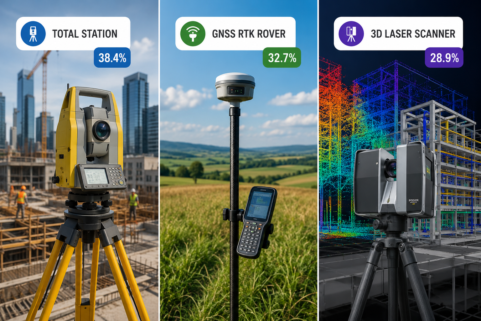
- Total stations hold the largest equipment segment share at 38.4%, while GNSS/RTK systems are the fastest-growing category [3].
- Drone and GIS integration is reducing survey time by over 50% in many project types, creating a strong competitive advantage for early adopters [4].
- North America leads regional growth with a 35.6% market share, driven by infrastructure investment and technology adoption [2].
- Surveyors who align equipment investment with infrastructure, renewable energy, and BIM-driven projects will be best positioned for long-term growth.
Market Scale and Growth Projections
Understanding the Numbers Behind the Boom
The scale of the land survey equipment market boom: trends and investment opportunities in 2026 becomes clear when the data is examined closely. The global market sits at USD 8.7 billion this year and is forecast to reach USD 13.2 billion by 2036, representing a compound annual growth rate of 4.2% [1]. These are not speculative figures. They reflect confirmed spending patterns across infrastructure, construction, renewable energy, and urban development sectors worldwide.
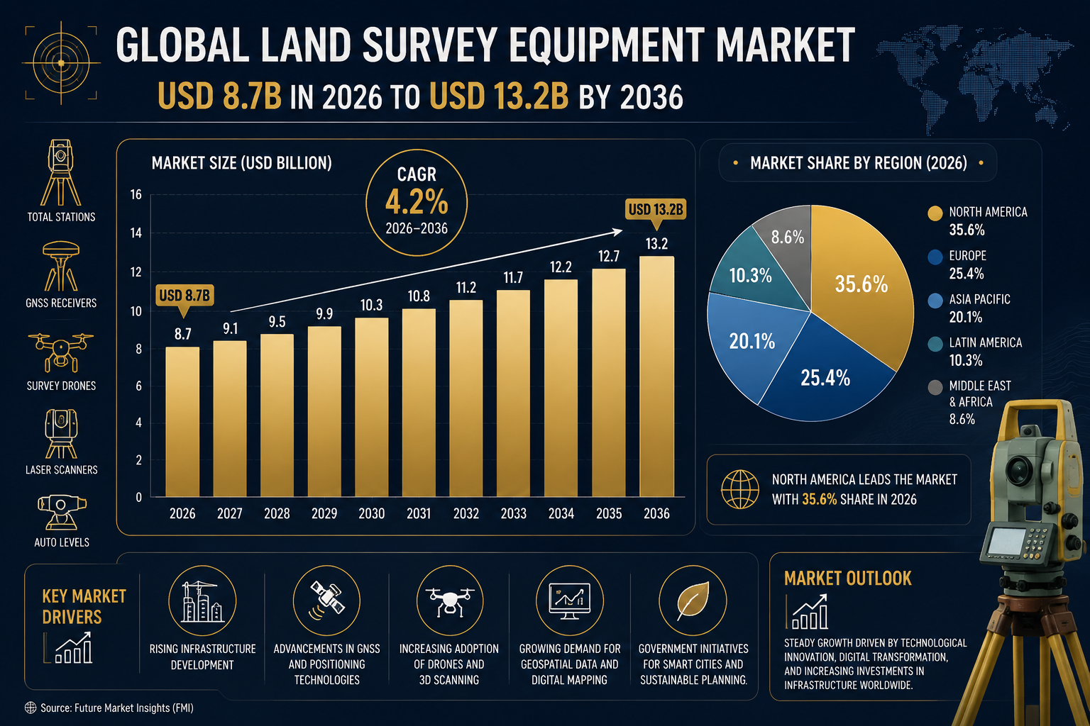
North America is the fastest-growing region, commanding a 35.6% share of the global market. The United States alone accounts for 21.4% of total global demand, driven by federal infrastructure legislation, highway expansion programmes, and utility grid modernisation projects [2]. Asia-Pacific follows closely, with rapid urbanisation in countries such as India, Vietnam, and Indonesia creating sustained demand for land measurement tools. Africa, though a smaller market today, is emerging as a significant growth frontier as urban migration accelerates [6].
Key regional market shares in 2026:
| Region | Market Share |
|---|---|
| North America | 35.6% |
| United States (within North America) | 21.4% |
| Asia-Pacific | Growing rapidly |
| Europe | Stable, BIM-driven demand |
| Africa | Emerging frontier |
For surveyors operating in the UK, these global trends have direct local relevance. Infrastructure investment, housing development targets, and commercial construction activity are all driving demand for chartered surveying services. Firms working across commercial building surveys and large-scale development projects are already feeling the impact of increased workloads tied to this global expansion.
Equipment Segments Driving the Market
Total Stations, GNSS/RTK, and Laser Scanners Compared
The three primary equipment categories each tell a different story about where the market is heading. Understanding their individual trajectories helps surveyors make smarter investment decisions.
Total Stations remain the dominant segment, holding 38.4% of the global market share in 2026 [3]. These instruments are the workhorses of high-precision layout and control network operations. Modern robotic total stations now integrate onboard software, Bluetooth connectivity, and automated target recognition, reducing the need for two-person crews. Their dominance reflects the continued reliance on precise angular and distance measurement across construction, engineering, and boundary work.
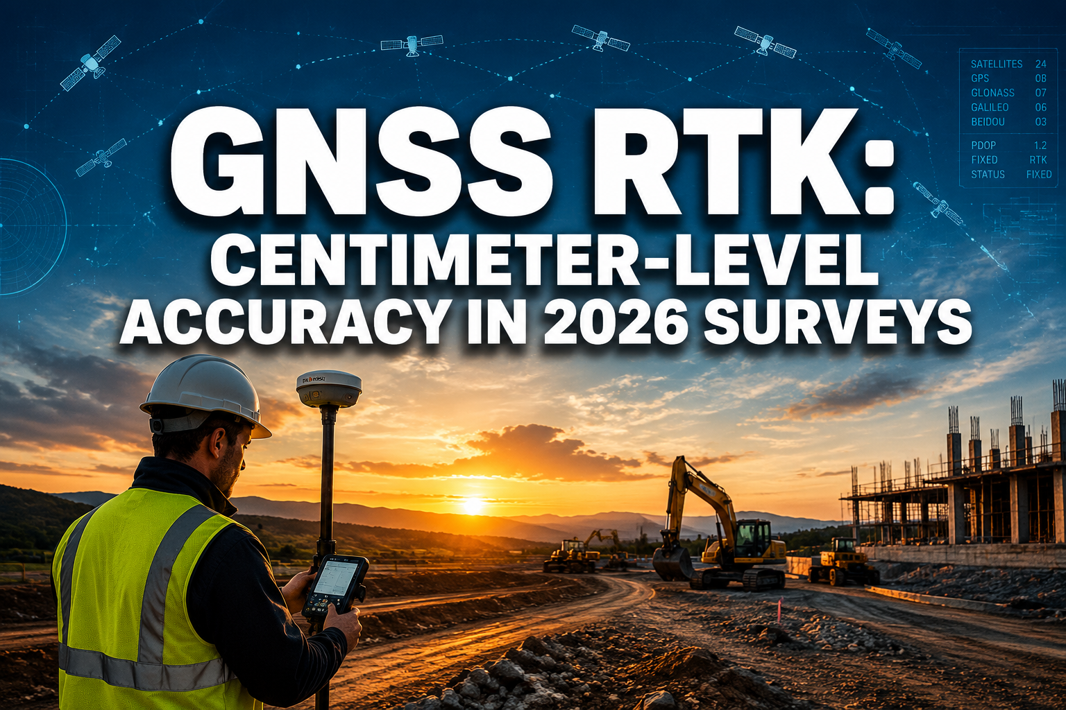
GNSS/RTK Systems are the fastest-growing category in the current market cycle [3]. The shift to multi-constellation GNSS — combining GPS, GLONASS, Galileo, and BeiDou signals — has dramatically improved reliability in challenging environments. RTK corrections delivered via mobile networks have made real-time centimetre-level accuracy accessible even in remote locations. For open-sky topographic surveys and construction stakeout work, these systems now offer a compelling combination of speed and accuracy that is difficult to match with conventional methods.
Laser Scanners, while still the smallest segment by revenue, are expanding at a notable pace [3]. Their growth is closely tied to the rise of Building Information Modelling (BIM) and digital twin projects. A single laser scan can capture millions of data points in minutes, producing dense 3D point clouds that feed directly into BIM workflows. As more construction and infrastructure projects mandate BIM compliance, demand for scanning capability will continue to rise.
"The surveyor who understands which tool to deploy on which project — and why — will consistently outperform peers who rely on a single instrument for every task."
For UK-based professionals, the practical application of these technologies is already visible in services such as drone surveys, which combine aerial data capture with GIS processing to deliver survey outputs that would have taken days using traditional methods. Similarly, structural surveys increasingly rely on digital measurement tools to document complex building conditions with greater accuracy and speed.
Key Drivers of the 2026 Land Survey Equipment Market Boom
Infrastructure, Urbanisation, and Renewable Energy
Three macro-level forces are primarily responsible for the land survey equipment market boom: trends and investment opportunities in 2026. Each creates distinct demand patterns that surveyors and investors should understand.
Infrastructure Development is the single largest driver. Government-backed programmes across North America, Europe, and Asia are directing trillions of dollars into transportation networks, bridges, tunnels, water systems, and utility upgrades [5]. Every major infrastructure project requires precise surveying at multiple stages — from initial site assessment through design, construction monitoring, and final as-built documentation. The volume of active projects in 2026 is creating sustained, multi-year demand for both equipment and professional services.
Urbanisation is adding further pressure, particularly in Asia and Africa [6]. As cities expand, the need for accurate land boundary definition, topographic mapping, and utility corridor planning grows proportionally. In rapidly developing economies, surveying capacity is often a bottleneck that limits how quickly construction can proceed. This creates strong incentives for both public and private investment in surveying infrastructure and equipment.
Renewable Energy Projects represent a newer but increasingly significant driver [1]. Solar farms, wind installations, and associated grid infrastructure require extensive land surveys before, during, and after construction. The global push toward net-zero targets is translating directly into survey project pipelines that will sustain demand well beyond 2026.
Technological Integration amplifies all three drivers. The combination of drones and Geographic Information Systems (GIS) has reduced survey time by over 50% on many project types [4]. This efficiency gain does not simply lower costs — it expands the range of projects that are economically viable to survey, effectively growing the total addressable market.
For UK surveyors, the connection between these global drivers and domestic practice is direct. Services ranging from RICS building surveys to subsidence surveys increasingly depend on digital measurement tools that are part of the same global equipment market described here. Keeping pace with technological advances is not optional — it is a competitive necessity.
Investment Strategies for Surveyors in 2026
Choosing the Right Equipment for Competitive Advantage
The land survey equipment market boom: trends and investment opportunities in 2026 presents surveyors with both a challenge and a clear strategic opportunity. The challenge is that equipment costs are rising alongside demand. The opportunity is that the right investment now can significantly differentiate a practice from competitors still relying on older workflows.
A practical investment framework for 2026:
-
Assess your project mix first. A firm primarily doing boundary and construction layout work should prioritise a modern robotic total station with network connectivity. Firms with significant topographic or infrastructure work should evaluate GNSS/RTK upgrades. Those moving into BIM or heritage documentation should consider entry-level laser scanning.
-
Factor in software, not just hardware. The value of modern survey equipment is inseparable from the software that processes its output. Point cloud processing, GIS integration, and BIM export capabilities all require investment beyond the instrument itself.
-
Consider leasing for high-cost items. Laser scanners and advanced GNSS systems carry significant upfront costs. Leasing arrangements can provide access to current-generation equipment without the capital commitment, while preserving cash flow for other business needs.
-
Invest in training alongside tools. Equipment that is not used to its full capability delivers a fraction of its potential return. Structured training on new instruments and software is a direct investment in productivity.
-
Monitor the drone survey segment closely. The drone survey market is one of the fastest-evolving areas within the broader equipment sector. Regulatory frameworks are maturing, and the cost of capable systems is falling. For firms not yet operating drones, 2026 represents a practical entry point.
The connection between equipment investment and service quality is also relevant for clients. Surveyors using current-generation tools can deliver RICS specialist defect surveys and schedule of condition reports with greater precision and faster turnaround, which directly supports client satisfaction and repeat business.
Challenges and Risks to Monitor
What Could Slow the Market
No market boom is without its complications. Several factors could moderate growth or create specific risks for surveyors and investors.
High equipment costs remain a barrier, particularly for smaller firms and practitioners in developing markets. The most capable total stations, GNSS systems, and laser scanners carry price tags that can be prohibitive without financing support [7].
Skilled labour shortages are a persistent constraint. Advanced equipment requires trained operators. In many markets, the supply of qualified surveyors is not keeping pace with demand, which limits how quickly firms can scale capacity even when equipment is available [6].
Data management complexity is growing alongside equipment capability. Drone surveys, laser scans, and GNSS datasets generate large volumes of data that require robust processing pipelines and storage infrastructure. Firms without adequate IT systems can find that data management costs erode the efficiency gains from new equipment.
Regulatory and standards compliance adds another layer of complexity. As digital survey methods become more common, professional standards bodies are updating requirements for data quality, methodology documentation, and output formats. Staying current with these requirements is an ongoing investment in itself.
Conclusion
The land survey equipment market boom: trends and investment opportunities in 2026 is not a passing trend. It is the result of converging forces — infrastructure investment, urbanisation, renewable energy growth, and digital integration — that will sustain demand for precision surveying tools well into the next decade. The market's projected growth from USD 8.7 billion in 2026 to USD 13.2 billion by 2036 reflects a structural shift in how land, buildings, and infrastructure are measured, documented, and managed [1].
Actionable next steps for surveyors and investors:
- Conduct an honest audit of current equipment against the project types your firm is winning and targeting.
- Prioritise GNSS/RTK upgrades if open-sky and construction work dominates your pipeline — this is the fastest-growing segment for good reason.
- Explore laser scanning capability if BIM or heritage documentation is part of your growth strategy.
- Integrate drone survey capability or build partnerships with specialist drone operators to expand service offerings without full capital commitment.
- Review software and data management infrastructure — equipment investment without processing capability delivers diminished returns.
- Stay connected to professional standards updates from RICS and equivalent bodies to ensure compliance as digital methods evolve.
The firms that treat equipment investment as a strategic decision — aligned with market trends, client needs, and service differentiation — will be the ones that capture the most value from this market expansion.
References
[1] Land Survey Equipment Market – https://www.futuremarketinsights.com/reports/land-survey-equipment-market?utm_source=openai
[2] Land Survey Equipment Market – https://www.futuremarketreport.com/industry-report/land-survey-equipment-market?utm_source=openai
[3] 2026 Land Survey Equipment Boom Comparing Total Stations Gps Rtk And Laser Scanners – https://princesurveyors.co.uk/blog/2026-land-survey-equipment-boom-comparing-total-stations-gps-rtk-and-laser-scanners/?utm_source=openai
[4] Land Survey Equipment Market 109381 – https://www.globalgrowthinsights.com/market-reports/land-survey-equipment-market-109381?utm_source=openai
[5] Top Land Survey Equipment For 2026 Reviewing Total Stations Rtk Gps And Laser Scanners Amid Market Boom – https://princesurveyors.co.uk/blog/top-land-survey-equipment-for-2026-reviewing-total-stations-rtk-gps-and-laser-scanners-amid-market-boom/?utm_source=openai
[6] Navigating The 2026 Land Survey Equipment Boom Total Stations Gps And Laser Scanners Reviewed – https://nottinghillsurveyors.com/blog/navigating-the-2026-land-survey-equipment-boom-total-stations-gps-and-laser-scanners-reviewed?utm_source=openai
[7] Land Survey Equipment Market Boom 2026 Investment Guide For Surveyors Facing Usd 8 7 Billion Surge – https://nottinghillsurveyors.com/blog/land-survey-equipment-market-boom-2026-investment-guide-for-surveyors-facing-usd-8-7-billion-surge?utm_source=openai