The global mobile mapping market is on track to reach USD 66.7 billion by 2026, up from USD 27.3 billion in 2021 — a compound annual growth rate of 19.5% [5]. That explosive growth is not driven by novelty. It is driven by a single, urgent need: the ability to capture the physical world in precise digital detail, fast, without hauling a lorry-load of equipment to every site.
Mobile 3D mapping techniques: creating digital twins for indoor and outdoor surveys sit at the heart of this shift. Whether the goal is monitoring a construction project, assessing a heritage building, or planning a complex urban redevelopment, flexible mobile scanning systems are replacing days of static survey work with hours of walk-and-scan efficiency. This article breaks down how these techniques work, where they excel, and how property and construction professionals can put them to use in 2026.
Key Takeaways 📌
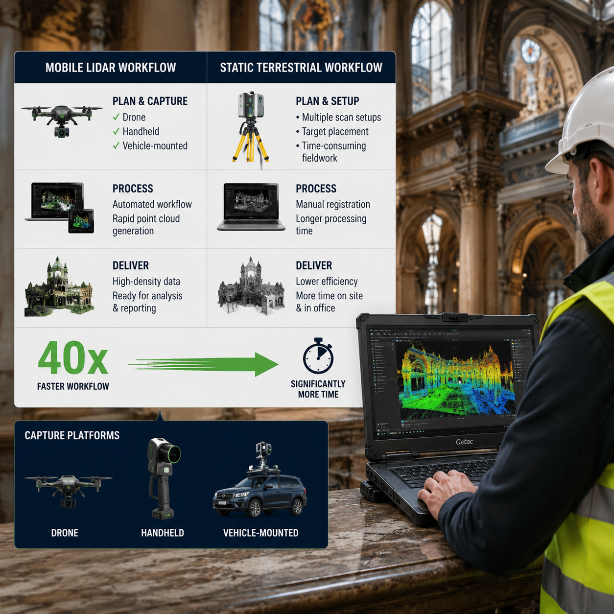
- Mobile 3D mapping systems can be up to 40× faster than traditional static laser scanning, cutting survey time and cost dramatically [1].
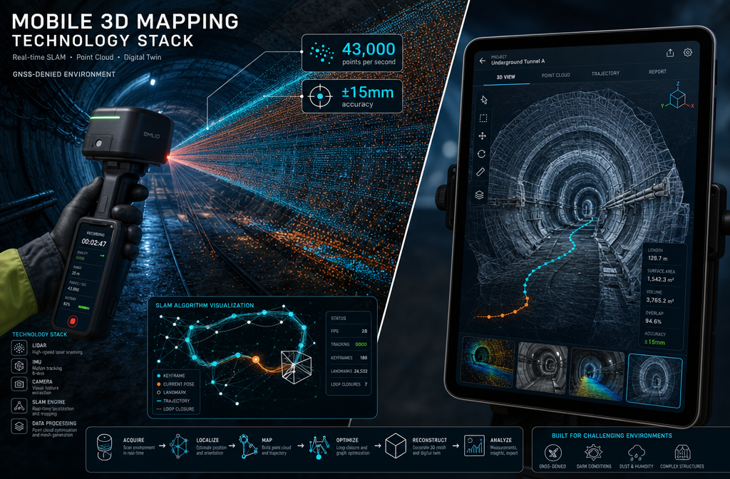
- SLAM-based handheld devices achieve ±15 mm accuracy, making them viable for engineering-grade digital twins even without GPS [1].
- Digital twins built from mobile scans support the full property lifecycle — from initial surveys and structural assessments to ongoing facility management.
- Hybrid workflows combining mobile and static LiDAR deliver the best balance of speed and precision for complex projects.
- The technology is accessible to non-expert operators, lowering the barrier for adoption across property, construction, and infrastructure sectors.
What Is Mobile 3D Mapping and Why Does It Matter?
Traditional land and building surveys relied on static instruments — total stations, fixed laser scanners on tripods, or photogrammetry rigs that required careful setup at every station. Each setup took time. Moving between stations took more time. For large, complex sites, a full survey could take days.
Mobile 3D mapping changes the equation entirely. Instead of stopping to scan, the operator moves through the environment continuously while sensors capture millions of data points per second. The result is a dense, geo-referenced point cloud — a three-dimensional constellation of measurements that describes every surface in the survey area with millimetre-level detail [6].
That point cloud becomes the raw material for a digital twin: a virtual replica of a physical space that can be interrogated, measured, and updated over time. Digital twins built from mobile scans are used for:
- 🏗️ Construction monitoring — tracking progress against design models
- 🏛️ Heritage documentation — preserving accurate records of historic structures
- 🏢 Facility management — maintaining up-to-date floor plans and asset inventories
- 🛣️ Infrastructure inspection — assessing roads, tunnels, bridges, and utilities
- 🏠 Property surveys — supporting structural surveys and condition assessments
"Mobile scanning is not just faster — it is fundamentally more flexible. It goes where static scanners cannot." [1]
Core Technologies Behind Mobile 3D Mapping Techniques: Creating Digital Twins for Indoor and Outdoor Surveys
LiDAR: The Engine of Point Cloud Capture
LiDAR (Light Detection and Ranging) is the dominant sensor technology in mobile 3D mapping. It fires rapid pulses of laser light and measures the time each pulse takes to return after bouncing off a surface. Repeat this millions of times per second across a rotating or multi-beam array, and the result is an extraordinarily dense spatial dataset [6].
Modern mobile LiDAR units are compact enough to be carried in a backpack, mounted on a vehicle, attached to a drone, or held in one hand. The GeoSLAM ZEB-REVO, for example, collects over 43,000 points per second at an average accuracy of ±15 mm [1] — figures that were unthinkable for handheld devices just a decade ago.
SLAM: Mapping Without GPS
One of the biggest breakthroughs enabling indoor digital twins is SLAM (Simultaneous Localisation and Mapping). Borrowed from robotics, SLAM allows a device to build a map of its environment while simultaneously tracking its own position within that map — all without relying on GPS or GNSS signals [1].
This is critical for surveying:
| Environment | GPS Available? | SLAM Required? |
|---|---|---|
| Open outdoor sites | ✅ Yes | Optional |
| Dense urban canyons | ⚠️ Partial | Recommended |
| Building interiors | ❌ No | Essential |
| Underground tunnels | ❌ No | Essential |
| Basements / car parks | ❌ No | Essential |
Research presented at EGU 2026 confirms that mobile LiDAR/SLAM systems, when paired with optimised processing workflows, can meet "stringent precision requirements of engineering-grade projects" across complex environments including campuses, tunnels, caves, and vegetated areas [4]. This makes them genuinely viable for the kind of integrated indoor–outdoor digital twins that large property and infrastructure projects demand.
Photogrammetry and Multi-Sensor Fusion
While LiDAR captures geometry, photogrammetry adds colour and texture by processing overlapping photographs to reconstruct 3D surfaces. Many modern mobile mapping rigs combine both — LiDAR for accuracy, cameras for visual richness [3].
Multi-sensor fusion goes further, integrating:
- IMU (Inertial Measurement Units) for motion tracking
- GNSS receivers for outdoor geo-referencing
- Cameras for RGB texture and photogrammetric redundancy
- Barometers for vertical positioning in multi-storey buildings
The output is a richly detailed, accurately positioned digital twin that can be overlaid on OS mapping, imported into BIM software, or shared via cloud platforms [6].
Indoor vs Outdoor Surveys: How Mobile 3D Mapping Techniques Work in Practice
Outdoor Surveys: Speed at Scale
For outdoor environments — streets, campuses, large construction sites, infrastructure corridors — mobile mapping systems mounted on vehicles or drones deliver unmatched coverage speed. A vehicle-mounted system can survey kilometres of road in a single pass, capturing kerb lines, utilities, signage, and building facades simultaneously [6].
Drone-based photogrammetry adds a vertical dimension, capturing rooftops and elevated facades that ground-level systems miss. This is particularly valuable for:
- Roof surveys where access is difficult or dangerous
- Large-scale topographic mapping for planning applications
- Monitoring earthworks and excavations on construction sites
- Assessing subsidence surveys by tracking ground movement over time
The APM notes that mobile scanners can also be deployed remotely — via pulley systems, autonomous vehicles, or drones — to capture hazardous or inaccessible areas that would otherwise be missing from the digital twin [1]. This is a significant safety advantage for surveys near unstable structures, live roads, or contaminated land.
Indoor Surveys: Navigating GNSS-Denied Spaces
Indoor environments present the greatest technical challenge — and the greatest opportunity for mobile 3D mapping. SLAM-based handheld devices allow a surveyor to walk through a building at a normal pace, scanning rooms, corridors, stairwells, and service voids in a single continuous capture session [1].
The practical benefits are substantial:
- No tripod setup — the operator simply walks and scans
- No GPS dependency — SLAM handles positioning autonomously
- Minimal disruption — buildings can remain occupied during survey
- Rapid coverage — a typical floor plate can be scanned in minutes rather than hours
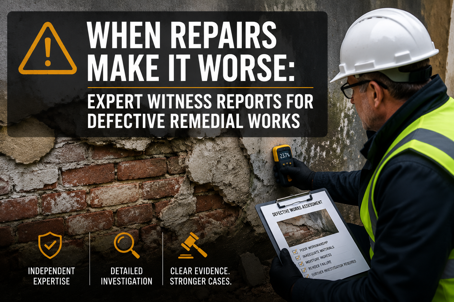
For property professionals, this opens up new possibilities for dilapidation surveys, commercial building surveys, and pre-acquisition condition assessments. A detailed 3D record of a building's condition at a specific point in time — captured in hours rather than days — provides a powerful evidential baseline for disputes, negotiations, or planned works.
Seamless Indoor–Outdoor Integration
The most powerful digital twins combine both environments. A seamless indoor–outdoor model might capture:
- The building's external envelope and surrounding site (drone + vehicle LiDAR)
- All internal floor plans and room geometry (handheld SLAM)
- Structural elements, MEP services, and finishes (close-range scanning)
- Sub-surface features such as drainage runs (GPR integration)
For projects involving drainage surveys or solid floor slab surveys, integrating sub-surface data into the same digital twin model creates a genuinely comprehensive asset record — one that supports everything from planning applications to maintenance scheduling.
Choosing the Right Approach: A Practical Comparison
Not every project needs the same solution. The table below summarises the main mobile 3D mapping approaches and their ideal use cases.
| Method | Best For | Accuracy | Speed | Cost |
|---|---|---|---|---|
| Vehicle-mounted LiDAR | Roads, large outdoor sites | High | Very fast | High |
| Handheld SLAM (e.g. ZEB-REVO) | Indoor spaces, tunnels | ±15 mm | Fast | Medium |
| Drone photogrammetry | Rooftops, large areas | Medium-High | Fast | Medium |
| Backpack LiDAR | Mixed indoor/outdoor | High | Fast | Medium-High |
| Static terrestrial LiDAR | High-precision detail | Very high | Slow | High |
| Hybrid (mobile + static) | Complex, high-stakes projects | Very high | Medium | High |
When to Use Hybrid Workflows
For high-stakes projects — heritage buildings, structural assessments, legal disputes — a hybrid workflow combining mobile scanning for broad coverage with static terrestrial LiDAR for critical detail areas is emerging as best practice [7]. The mobile pass captures the overall geometry quickly; the static scanner fills in areas where maximum precision is needed.
This approach is particularly relevant for:
- RICS Level 3 Building Surveys where comprehensive condition evidence is required
- Specific defect reports requiring precise measurement of cracks, deflections, or movement
- Expert witness cases where survey accuracy may be challenged in court
The Speed Advantage: Numbers That Matter
The speed benefit of mobile scanning over static methods is not marginal. According to APM, walk-and-scan mobile workflows are reported to be up to 40 times faster than static tripod-based laser scanning, with minimal training needed for non-expert operators [1].
For a project team managing tight construction schedules or a surveyor balancing multiple instructions, that speed differential translates directly into:
- ✅ Lower site visit costs
- ✅ More frequent digital twin updates
- ✅ Faster delivery of survey reports
- ✅ Reduced disruption to building occupants
From Point Cloud to Digital Twin: The Processing Workflow
Capturing the data is only the first step. Converting a raw point cloud into a usable digital twin involves several processing stages:
- Registration — aligning multiple scan sessions into a single coordinate system
- Noise filtering — removing erroneous points caused by reflective surfaces, moving objects, or sensor noise
- Classification — labelling points by category (ground, vegetation, structure, etc.)
- Modelling — extracting surfaces, planes, and objects to create mesh models or BIM-ready geometry
- Validation — checking accuracy against known control points or reference measurements
- Delivery — exporting to formats such as IFC (for BIM), E57 (point cloud), or web-based viewers [3]
Leading software platforms for this workflow include Autodesk ReCap, Leica Cyclone, NavVis IVION, and open-source tools such as CloudCompare [3]. Cloud-based platforms increasingly allow clients to access and interrogate their digital twin directly via a browser, without specialist software.
"The digital twin is only as good as the workflow that builds it. Speed of capture means nothing if the output cannot be trusted."
Real-World Applications in Property and Construction
Construction Monitoring
Mobile 3D mapping enables regular, low-cost progress surveys throughout a construction project. Comparing each scan to the BIM design model highlights deviations before they become costly problems — a practice known as scan-to-BIM or as-built verification [7].
For projects subject to a licence to alter or party wall agreement, a timestamped digital twin provides an unambiguous record of the building's condition before, during, and after works — protecting all parties.
Heritage and Conservation
Historic buildings present unique survey challenges: irregular geometry, fragile surfaces, restricted access. Handheld SLAM devices navigate these constraints with ease, producing detailed 3D records that support conservation planning, grant applications, and listed building consent submissions.
Facility Management
For building owners and facilities managers, a regularly updated digital twin replaces outdated paper floor plans with a living, measurable model. Space utilisation, asset tracking, and maintenance planning all benefit from accurate, current spatial data.
Insurance and Legal Disputes
A mobile 3D scan taken immediately after an incident — a flood, a fire, a structural failure — creates an evidential record that is far more robust than photographs alone. The spatial data can be measured, re-examined, and presented in court if needed.
Challenges and Limitations to Consider
Mobile 3D mapping is powerful, but it is not without limitations:
- Reflective and transparent surfaces (glass, polished floors) can cause scan artefacts
- Dynamic environments (people, vehicles moving during scan) introduce noise
- Data volume — a single large-site scan can generate hundreds of gigabytes
- Processing expertise — converting raw point clouds to usable models still requires skilled operators
- Cost — high-end systems remain expensive to purchase, though hire options are increasingly available
For standard property surveys, traditional methods combined with targeted mobile scanning often represent the most cost-effective approach. The technology is a powerful complement to — not a replacement for — professional surveying judgement.
Conclusion: Actionable Next Steps for Property and Construction Professionals
Mobile 3D mapping techniques: creating digital twins for indoor and outdoor surveys have moved firmly into the mainstream of property and construction practice in 2026. The combination of SLAM accuracy, LiDAR speed, and increasingly accessible software means that detailed, reliable digital twins are no longer the preserve of major infrastructure projects.
What to do next:
- Assess your survey needs — identify projects where speed, accuracy, or inaccessibility make mobile scanning a clear advantage over traditional methods.
- Specify the right technology — match the scanning method (handheld, vehicle, drone, hybrid) to the project's accuracy requirements and environment.
- Engage qualified surveyors — ensure the professionals capturing and processing your data have the expertise to deliver survey-grade outputs, not just visually impressive point clouds.
- Integrate with existing workflows — connect digital twin outputs to your BIM, FM, or asset management systems for maximum long-term value.
- Update regularly — a digital twin that is never updated quickly becomes a historical record rather than a live asset. Build scan updates into project schedules and maintenance programmes.
For property owners, developers, and construction teams looking to understand how advanced survey techniques can support their projects, exploring the full range of professional survey services available from qualified chartered surveyors is an excellent starting point.
References
[1] How 3D Mobile Mapping Is Changing The Landscape Of Project Management – https://www.apm.org.uk/blog/how-3d-mobile-mapping-is-changing-the-landscape-of-project-management/
[3] Best 3D Mapping Software – https://www.skyebrowse.com/news/posts/best-3d-mapping-software
[4] EGU26-6560 – https://meetingorganizer.copernicus.org/EGU26/EGU26-6560.html
[5] Mobile Mapping Market – https://www.marketsandmarkets.com/PressReleases/mobile-mapping.asp
[6] Everything You Need To Know About 3D Mobile Mapping – https://www.navvis.com/blog/everything-you-need-to-know-about-3d-mobile-mapping
[7] Geo Week 2026 Wrap Up: Mobile Mapping, Autonomy And Real-World Workflows In Focus – https://www.exyn.com/news/geo-week-2026-wrap-up-mobile-mapping-autonomy-and-real-world-workflows-in-focus