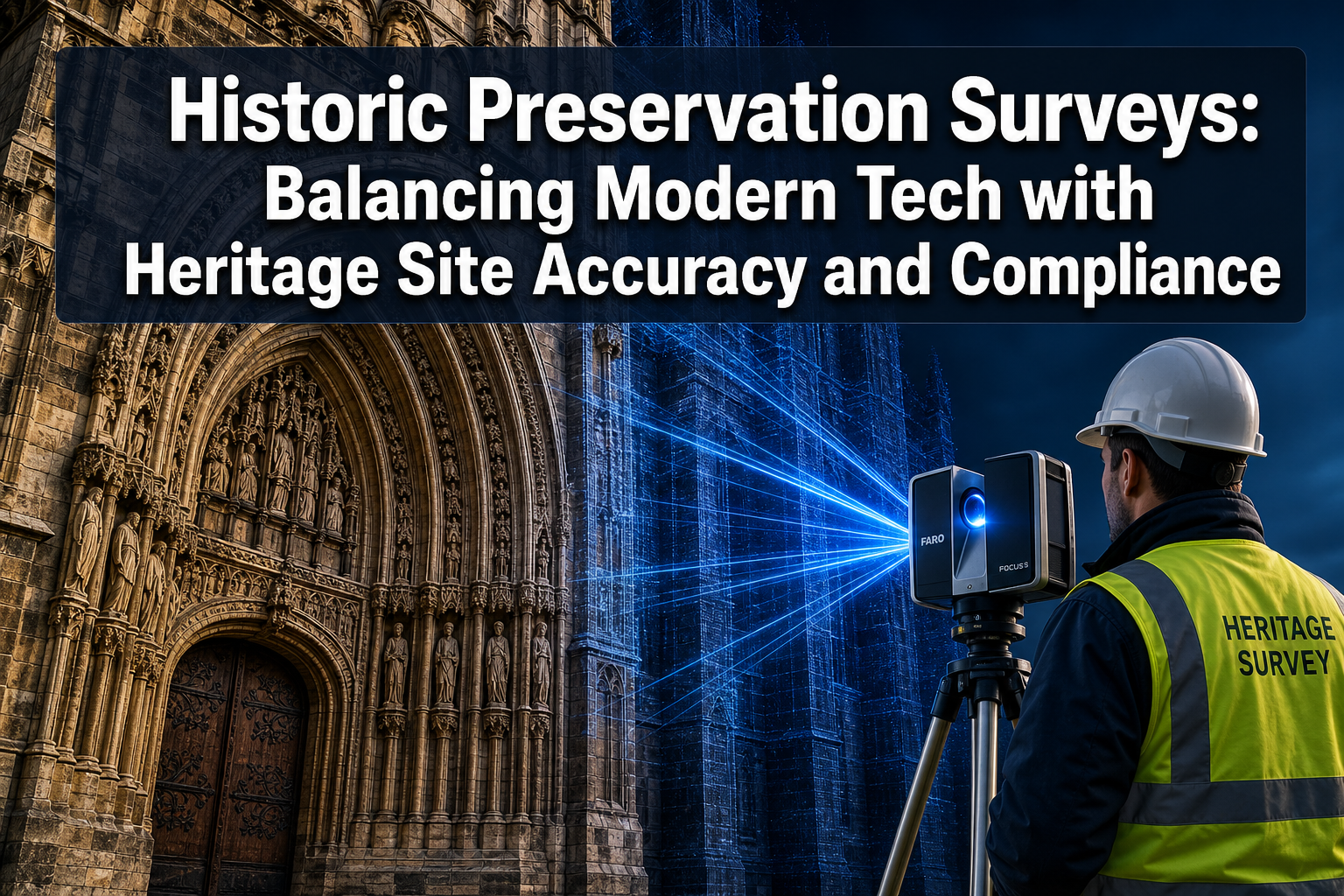
More than 95,000 properties sit on the U.S. National Register of Historic Places, yet a significant proportion lack complete, up-to-date survey documentation. That gap is not merely administrative — it creates real risk of irreversible structural damage during restoration, legal non-compliance, and the permanent loss of architectural knowledge. Historic Preservation Surveys: Balancing Modern Tech with Heritage Site Accuracy and Compliance sits at the intersection of cutting-edge scanning technology, rigorous professional standards, and the ethical responsibility to protect fragile built heritage for future generations.
In 2026, surveyors and conservation professionals face a sharper version of an old tension: the tools available are extraordinarily powerful, but the structures being documented are extraordinarily vulnerable. Getting that balance right requires understanding both the promise and the limits of modern technology.
Key Takeaways
- Laser scanning, photogrammetry, and mobile LiDAR have transformed heritage survey accuracy, but each carries specific limitations that require traditional methods as a backup.
- Non-invasive scanning is not just a best practice — for many listed and protected structures, it is an ethical and legal obligation.
- Federal and national guidelines (including those from the U.S. National Park Service) now formally integrate digital documentation while still requiring durable hard-copy records.
- Scan-to-BIM workflows can achieve tolerances as tight as plus or minus one-sixteenth of an inch, making them suitable for restoration fabrication.
- Data permanence and long-term accessibility must be planned from the outset, not treated as an afterthought.
Why Non-Invasive Scanning Has Become the Ethical Standard
Restoration projects involving fragile structures — whether a medieval church, a Georgian townhouse, or a pre-Civil War mill — demand a fundamental commitment: do no harm during documentation. Traditional survey methods such as direct contact measurement, probe testing, and manual coring can introduce micro-damage to already stressed materials. For Grade I listed buildings in England or National Historic Landmarks in the United States, even minor physical intervention during the survey phase can trigger regulatory scrutiny.
This is where non-invasive scanning technologies have moved from novelty to necessity.
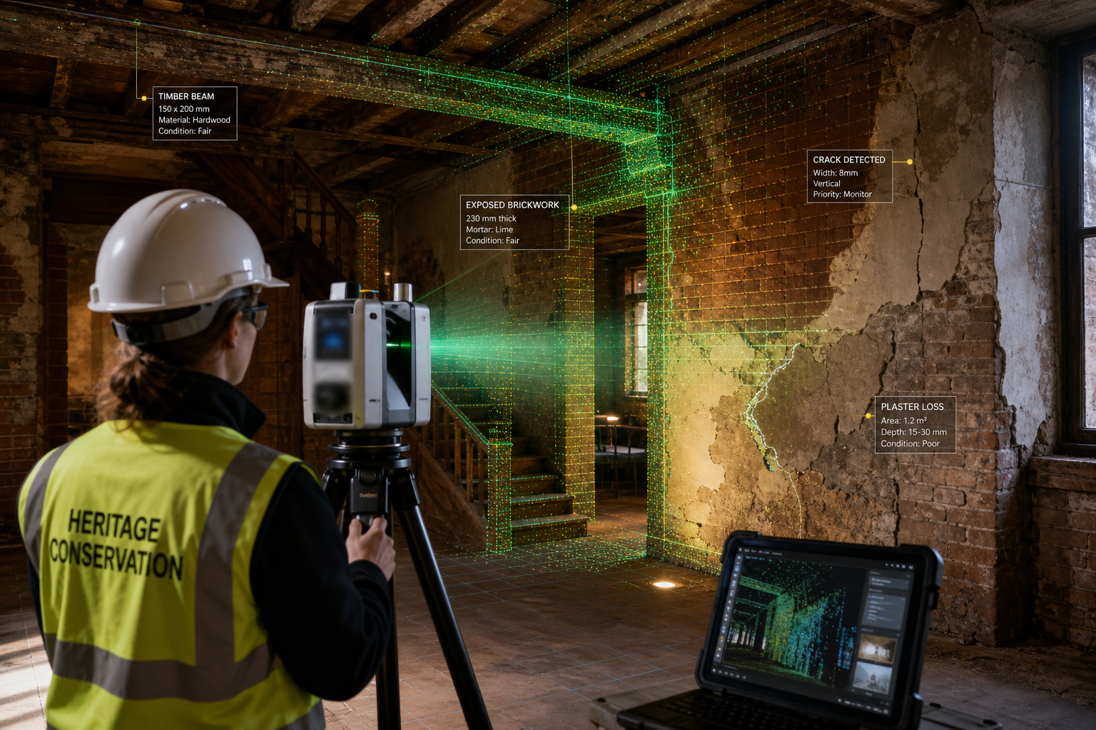
Terrestrial laser scanning (TLS) captures millions of precise 3D data points per second without touching the structure. The U.S. National Park Service's Heritage Documentation Programs (HDP) have incorporated high-definition TLS into nearly every major documentation project, citing both accuracy gains and the ability to record detail that would be physically impossible to capture by hand [1]. The result is a dense "point cloud" — a three-dimensional map of the structure's surface geometry — that can be revisited, measured, and analysed long after the site visit is complete.
Structure-from-Motion (SfM) photogrammetry offers a complementary, lower-cost approach. By processing overlapping photographs taken from multiple angles, SfM software reconstructs accurate 3D models of heritage surfaces. Accuracy depends heavily on image quality, overlap percentage, and lighting consistency, so meticulous planning is essential to produce reliable results [4]. For surveyors working on tight budgets or in environments where large equipment is impractical, SfM is often the most proportionate choice.
Mobile LiDAR enables rapid 3D digitisation of complex, multi-room heritage sites. A surveyor carrying a mobile unit can walk through a building and capture continuous point cloud data in a fraction of the time required by static scanner setups. However, mobile systems can introduce noise into point clouds and may capture varying levels of detail depending on walking speed and environment [3]. Careful quality-control protocols are non-negotiable.
"The goal is not to replace human expertise with sensors — it is to give human expertise a far more complete and accurate picture to work from."
The Ethics of Photogrammetry on Fragile Surfaces
Photogrammetry raises a specific ethical question that is often overlooked: does the act of photographing a heritage surface constitute documentation, or does it constitute a form of appropriation? For sites with indigenous cultural significance, or structures that communities regard as sacred, the answer may be complex. Surveyors working under the Historic Preservation Surveys: Balancing Modern Tech with Heritage Site Accuracy and Compliance framework must engage with site owners, local authorities, and community stakeholders before deploying any recording technology, however non-invasive it appears.
From a purely technical standpoint, photogrammetry on highly reflective surfaces — gilded decorations, glazed tiles, polished stone — can produce distorted models. The same challenge affects laser scanning, where reflective or transparent materials scatter or absorb the laser beam unpredictably [1]. In both cases, supplementary traditional hand measurements remain essential for verification.
For properties where structural concerns overlap with heritage sensitivity, a structural survey conducted by a chartered professional provides the rigorous baseline documentation that regulatory bodies expect.
Scan-to-BIM, AR Overlays, and the Accuracy Imperative
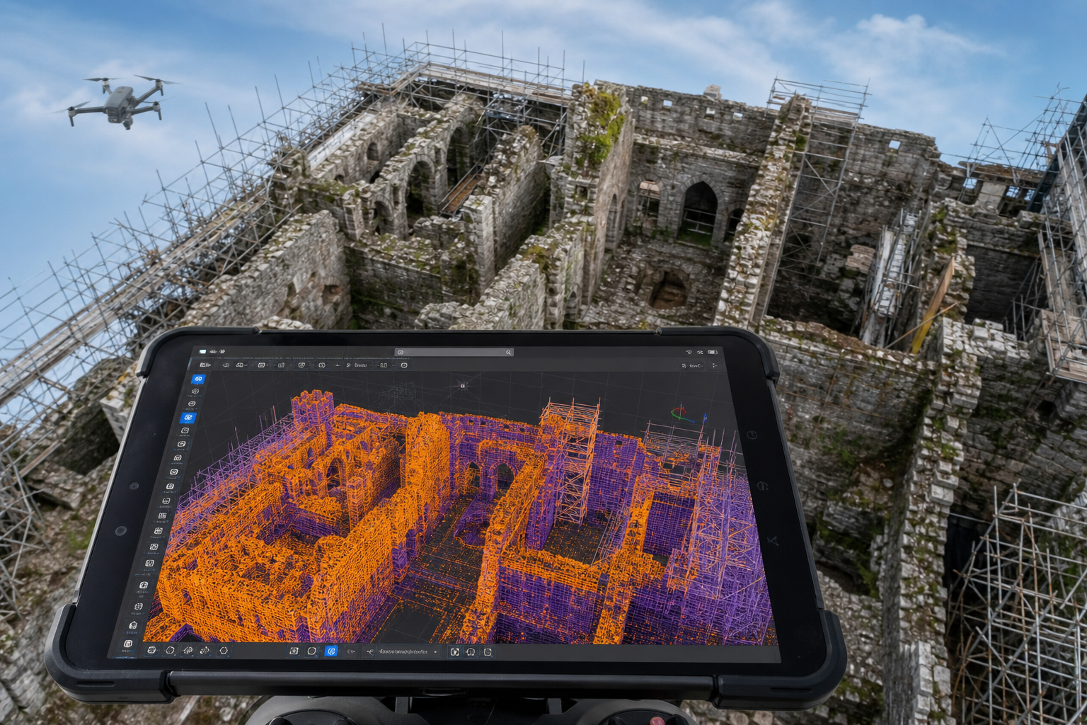
The phrase "scan-to-BIM" describes the workflow of converting raw point cloud data into an intelligent Building Information Model (BIM). For historic preservation, this workflow has moved well beyond concept stage. Specialist providers now offer scan-to-BIM services achieving tolerances of plus or minus one-sixteenth of an inch — a Level of Development (LOD) 400 standard that is directly suitable for restoration fabrication, meaning craftspeople can manufacture replacement components from the model data without additional site measurement [2].
This level of precision matters enormously when, for example, a damaged stone cornice must be replicated, or when structural steelwork needs to be threaded through a listed interior without disturbing original fabric. Inaccurate as-built documentation is one of the most common causes of costly renovation mistakes in heritage projects; modern laser scanning and total station equipment significantly reduces human error compared to traditional hand measurement alone [7].
Augmented Reality Overlays in Conservation Practice
Augmented Reality (AR) overlays represent the next step in applying digital survey data on-site. By superimposing a BIM model or historical drawing onto a live camera view of the structure, conservation architects and engineers can:
- Compare existing conditions against original design intent in real time
- Identify deviations, settlement, or loss of fabric that might be invisible to the naked eye
- Guide repair teams to exact locations of hidden features recorded in earlier surveys
- Demonstrate proposed interventions to planning authorities and heritage bodies without physical mock-ups
AR tools are still maturing in the heritage sector, and their accuracy depends entirely on the quality of the underlying survey data. A poorly georeferenced point cloud will produce an AR overlay that misleads rather than informs. This is why the survey foundation — the initial scanning, processing, and quality-checking phase — must be treated as the highest-priority investment in any heritage project.
For properties with complex structural conditions, a monitoring survey can track ongoing movement over time, feeding updated data into the BIM model and keeping the AR overlay current throughout a long restoration programme.
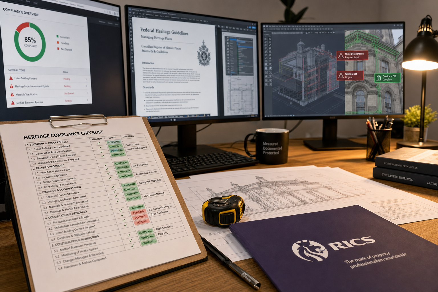
Navigating Federal and National Guidelines
In the United States, the Secretary of the Interior's Standards for the Treatment of Historic Properties set the overarching framework for what is permissible in preservation, rehabilitation, restoration, and reconstruction. The NPS Heritage Documentation Programs add technical specificity, and their laser scan guidance explicitly addresses how digital data should be collected, processed, and stored [1].
In England and Wales, Historic England's guidance notes and the requirements of listed building consent govern what survey methods are acceptable and what records must be submitted. The core principle across all major jurisdictions is consistent: documentation must be accurate, reproducible, and durable.
The durability requirement is where many technology-forward projects stumble. The NPS HDP specifically emphasises the importance of hard-copy records alongside digital files, citing concerns about data loss and technological obsolescence [1]. A point cloud stored in a proprietary format that becomes unreadable in twenty years is not a preservation record — it is a liability. Best practice in 2026 requires:
| Record Type | Recommended Format | Storage Requirement |
|---|---|---|
| Point cloud data | Open formats (e.g., .LAS, .E57) | Redundant off-site backup |
| Photogrammetry imagery | Uncompressed TIFF or RAW | Archival-grade storage media |
| BIM models | IFC (open standard) | Version-controlled repository |
| Hard-copy drawings | Archival-quality paper | Climate-controlled archive |
| Field notes | Acid-free paper | Physical archive |
A 2016 study highlighted the urgent need for standardised practices in archaeological and heritage survey data, noting that inconsistent methods and inadequate long-term storage planning were undermining the value of even technically excellent surveys [9].
For buildings with non-standard construction — including many historic structures built with now-unusual materials or techniques — specialist assessment of the structural fabric is essential before and after scanning. Guidance on non-standard construction surveys provides a useful framework for these cases.
Compliance, Data Quality, and the Human Element
Technology solves many problems in Historic Preservation Surveys: Balancing Modern Tech with Heritage Site Accuracy and Compliance — but it cannot replace professional judgement. Two persistent challenges illustrate why the human element remains central.
In-Field Analysis vs. Laboratory Standards
When surveyors analyse materials or artefacts on-site during a heritage survey, efficiency increases but accuracy can decrease. Research published in the journal Advances in Archaeological Practice found that in-field artefact analysis, while faster, can produce results that diverge meaningfully from laboratory-standard analysis [8]. For heritage surveys where material identification affects conservation decisions — for example, distinguishing original lime mortar from later Portland cement repairs — this gap can have significant consequences.
The practical implication is that field surveys should prioritise systematic sampling and recording over on-site interpretation wherever possible. Samples should be retained for laboratory analysis, and field observations should be clearly flagged as provisional in survey reports.
Inaccessible Environments and Specialist Equipment
Not all heritage structures are conveniently accessible. Underground vaults, narrow roof spaces, and partially collapsed sections present genuine challenges for standard survey equipment. Portable devices originally developed for speleological (cave) surveys — such as the DistoX2 — have been adapted for archaeological and heritage contexts, offering flexible mapping solutions in confined or hazardous environments [6]. Drone-mounted LiDAR and photogrammetry systems address the challenge of tall facades and roofscapes that cannot be safely accessed by scaffold.
For buildings where damp or moisture ingress is a concern — common in older masonry structures — a damp survey conducted alongside the heritage documentation survey provides a more complete picture of the building's condition and informs conservation priorities.
The Role of RICS-Accredited Building Surveys
For heritage properties in the UK, a RICS building survey provides the most comprehensive professional assessment of condition, combining visual inspection with specialist knowledge of historic construction. RICS-accredited surveyors are trained to recognise the difference between normal aging in historic fabric and active deterioration requiring intervention — a distinction that automated scanning systems cannot reliably make.
When a heritage property is being considered for purchase or development, choosing the right property survey is a critical early decision. A standard homebuyer report will not capture the complexity of a listed building's condition; a full building survey or specialist heritage assessment is almost always the appropriate choice.
Advances in Measured Survey Techniques
The integration of CAD and computer-based processing into measured survey workflows has been developing since the early 2000s, steadily improving both accuracy and the efficiency of producing final documentation [10]. What has changed dramatically in the past decade is the speed and resolution available through digital scanning, and the ability to share and collaborate on survey data across teams and geographies in near-real time.
Advancements in digital tools have also transformed disaster preparedness for heritage sites. Laser scanning and photogrammetry data now play a direct role in disaster risk management — providing baseline records that enable accurate reconstruction after fire, flood, or seismic events [5]. The Notre-Dame Cathedral restoration, for example, relied heavily on pre-existing point cloud data to guide rebuilding decisions after the 2019 fire.
For listed or heritage-sensitive commercial properties, a RICS commercial building survey provides the level of detail required by heritage bodies and lenders alike.
Conclusion: Actionable Steps for Heritage Survey Excellence
Historic Preservation Surveys: Balancing Modern Tech with Heritage Site Accuracy and Compliance is not a problem that technology alone will solve. The most effective heritage surveys in 2026 combine the precision of laser scanning and photogrammetry with the irreplaceable judgement of experienced professionals, the rigour of standardised data management, and genuine engagement with the regulatory frameworks that protect historic fabric.
Actionable next steps for professionals and property owners:
- Assess the structure's sensitivity before selecting survey technology. Fragile or reflective surfaces may require SfM photogrammetry rather than laser scanning, or a hybrid approach combining both.
- Commission a specialist heritage or RICS building survey before committing to any restoration or development programme. This establishes a defensible baseline and identifies risks early.
- Plan for data permanence from day one. Store point clouds and BIM models in open, non-proprietary formats. Maintain hard-copy archival drawings alongside digital records.
- Engage with the relevant regulatory body early. Whether that is Historic England, the NPS, or a local planning authority, early dialogue prevents costly compliance failures later.
- Use AR overlays and BIM models as communication tools, not just technical records. Presenting digital survey data visually to planning committees and heritage bodies significantly improves decision-making.
- Do not skip laboratory analysis of sampled materials. In-field observations are a starting point, not a conclusion.
- Consider ongoing monitoring surveys for structures undergoing active restoration or showing signs of movement, to keep documentation current throughout the project lifecycle.
The built heritage that survives into the future will be the heritage that was documented, understood, and protected with both the best available tools and the best available professional judgement. Neither alone is sufficient.
References
[1] Laser Scan Guidance – https://www.nps.gov/subjects/heritagedocumentation/laser-scan-guidance.htm?utm_source=openai
[2] Historic Preservation Scan To Bim Lod 400 Ready – https://www.roboticimaging.com/blog/historic-preservation-scan-to-bim-lod-400-ready?utm_source=openai
[3] Mobile Lidar Cultural Heritage2 – https://www.lefixea.com/article/mobile_lidar_cultural_heritage2?utm_source=openai
[4] Sfm Cultural Heritage3 – https://www.lefixea.com/article/sfm_cultural_heritage3?utm_source=openai
[5] S40494 023 01035 X – https://www.nature.com/articles/s40494-023-01035-x?utm_source=openai
[6] Ora Hyrax – https://www.anthro.ox.ac.uk/publication/1146992/ora-hyrax?utm_source=openai
[7] As Built Surveys Renovation Mistakes – https://www.topbimcompany.com/as-built-surveys-renovation-mistakes/?utm_source=openai
[8] 5e9a0c32103635a680db3bddd3137ba6 – https://www.cambridge.org/core/journals/advances-in-archaeological-practice/article/accuracy-and-adequacy-of-infield-artifact-analysis/5E9A0C32103635A680DB3BDDD3137BA6?utm_source=openai
[9] 303463999 Archaeological Survey Data Quality Durability And Use In The United States Findings And Recommendations – https://www.researchgate.net/publication/303463999_Archaeological_Survey_Data_Quality_Durability_and_Use_in_the_United_States_Findings_and_Recommendations?utm_source=openai
[10] 13556207.2003 – https://www.tandfonline.com/doi/abs/10.1080/13556207.2003.10785343?utm_source=openai