

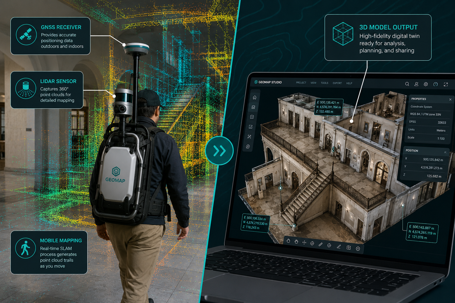
A handheld scanner the size of a water bottle can now capture a complete building interior in under ten minutes — generating a millimetre-accurate 3D model before the surveyor has even left the site. That is not a future promise; it is the operational reality driving the advancements in mobile 3D mapping: creating detailed property models on the go in 2026.
The global mobile mapping market was valued at USD 27.3 billion in 2021 and is forecast to reach USD 116.45 billion by 2029 at a compound annual growth rate of roughly 21% [3][5]. Property modelling, real estate, and construction are among the fastest-growing demand segments. For surveyors, property professionals, and project managers, understanding these shifts is no longer optional — it is a competitive necessity.
Key Takeaways 📌
- Mobile 3D mapping has moved mainstream — handheld SLAM LiDAR, backpack rigs, and vehicle-mounted systems now generate detailed property models without bulky, static equipment.
- The market is growing at ~19–21% CAGR, driven by real estate, smart cities, and infrastructure digital twin demand.
- AI and 3D Gaussian splatting are accelerating how quickly raw mobile imagery becomes photorealistic, measurable property models.
- GIS integration is now standard, enabling richer land-use analysis and asset management directly from on-the-go capture data.
- Surveyors adopting these tools in 2026 can dramatically reduce site time, improve report accuracy, and offer clients richer deliverables.
What Is Mobile 3D Mapping and Why Does It Matter for Property?
Traditional property surveys relied on static total stations, tape measures, and fixed laser scanners. Each setup took time, required skilled operators, and produced data in silos. Mobile 3D mapping replaces that workflow with systems that capture spatial data continuously while moving — on foot, by vehicle, or via drone.
At the core of modern mobile mapping is SLAM (Simultaneous Localisation and Mapping) — an algorithm that builds a 3D map of an environment in real time while tracking the device's position within it. Combined with LiDAR (Light Detection and Ranging) sensors, inertial measurement units (IMU), and GNSS receivers, these systems produce dense point clouds: three-dimensional grids of millions of data points that describe every surface in a scene.
For property professionals, this means:
| Traditional Method | Mobile 3D Mapping |
|---|---|
| Hours of static setup per room | Full building scanned in minutes |
| Manual measurements, human error risk | Automated, millimetre-level accuracy |
| Data processed days later in office | Near real-time model generation on-site |
| Separate indoor and outdoor datasets | Seamless indoor–outdoor capture in one pass |
| High equipment cost, specialist-only | Increasingly accessible to general surveyors |
The Association for Project Management notes that modern handheld mobile mapping systems can scan complex structures — buildings, tunnels, and large sites — and instantly generate detailed 3D maps, fundamentally changing how project teams track progress and document assets [1].
For those considering the right survey approach for a property, understanding how technology enhances traditional methods is valuable context — see this guide on choosing the right property survey for a broader overview.
The Hardware Revolution: Flexible Systems Without the Bulk
One of the most significant advancements in mobile 3D mapping: creating detailed property models on the go has been the miniaturisation and flexibility of hardware. The era of requiring a van-sized rig to capture a building is ending.
Backpack and Handheld Systems 🎒
Platforms like the Mosaic Explorer backpack use global-shutter, multi-camera rigs that can be carried on foot, mounted on a bicycle, or attached to a scooter. Global-shutter sensors eliminate the motion blur that plagued earlier rolling-shutter cameras, producing sharper point clouds and better-colourised geometry — critical for capturing property façades and interiors at realistic walking speeds [2].
Key advantages for surveyors:
- Capture narrow corridors, staircases, and loft spaces that vehicles cannot access
- Transition seamlessly from outdoor façade to indoor floor plan in a single session
- Reduce setup time from hours to minutes
- No specialist vehicle or road closure required
Vehicle-Mounted Systems 🚗
For larger sites — commercial estates, campus environments, or streetscape assessments — vehicle-mounted mobile mapping systems remain powerful tools. OXTS identifies top 2026 use cases including road asset inventories, urban mapping, and corridor surveys where 3D data is captured at traffic speeds [6]. These systems generate detailed 3D property context — façades, boundary features, site furniture — in a single pass.
UAV Integration 🚁
Drone-based capture completes the picture. Platforms like SkyeBrowse allow users to capture a property in minutes from above and receive a scaled 3D model with measurement and annotation tools shortly after [4]. When combined with ground-based mobile mapping, the result is a complete indoor–outdoor digital twin — something that would have required weeks of work just five years ago.
"The convergence of backpack LiDAR, vehicle rigs, and UAV photogrammetry into unified reality capture stacks is the defining hardware trend of 2026."
For surveyors working on structural surveys or RICS building surveys, these tools add a powerful layer of spatial documentation to traditional inspection workflows.
Software, AI, and GIS: Turning Raw Data Into Property Intelligence
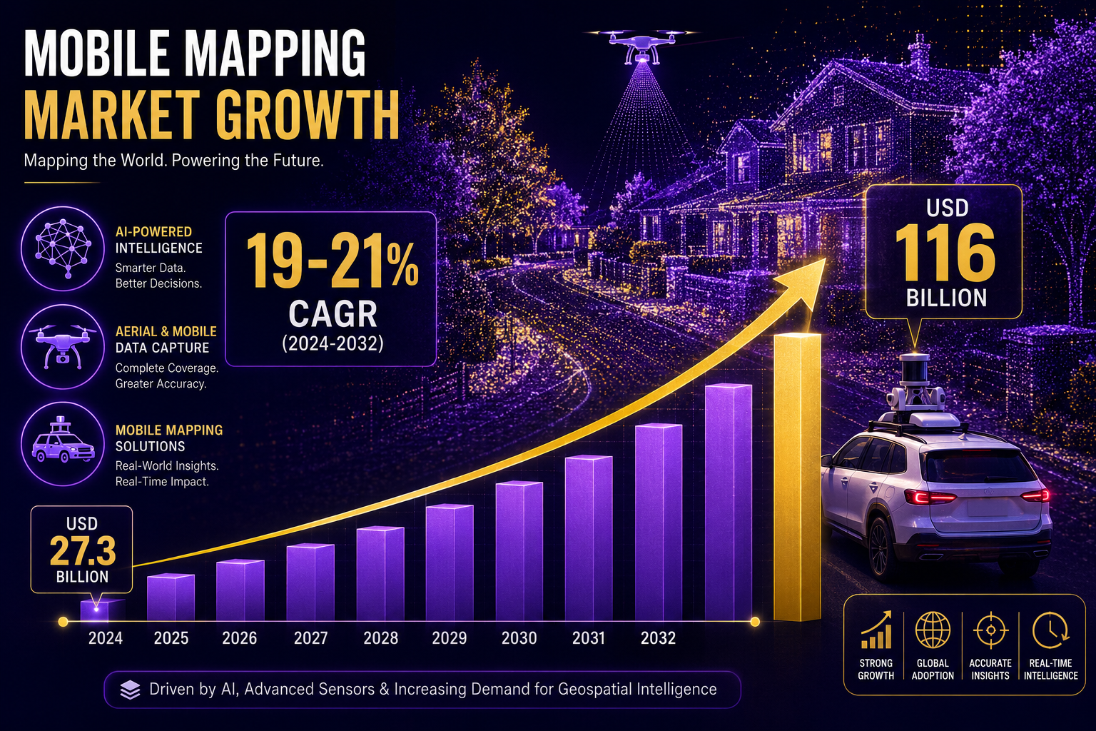
Hardware captures the data — but software transforms it into actionable property intelligence. The advancements in mobile 3D mapping: creating detailed property models on the go are arguably more dramatic on the software side than the hardware side in 2026.
3D Gaussian Splatting: The Next Frontier 🔬
Traditional photogrammetry pipelines process thousands of images into mesh models over hours. 3D Gaussian splatting — a neural rendering technique — reconstructs highly detailed, view-consistent 3D scenes from multi-view imagery far faster than classic methods [2]. For mobile mapping, where a single session might generate tens of thousands of frames, this is transformative.
The result: photorealistic property models that look like photographs but are fully measurable and navigable in 3D. Clients can virtually walk through a property before a single physical decision is made.
AI-Powered Semantic Segmentation 🤖
AI is not just speeding up processing — it is adding meaning to point clouds. Machine learning models now automatically identify and label building elements:
- 🏠 Roof types and conditions
- 🪟 Window and door positions
- 🧱 Wall materials and surface defects
- 🌳 Vegetation encroachment
- ⚡ Utility infrastructure
Industry analysis of North American market trends highlights AI-powered feature extraction and classification as a critical capability that reduces manual post-processing costs and makes on-the-go property mapping scalable for commercial deployment [8].
GIS Integration for Land-Use Analysis 🗺️
Perhaps the most practically powerful development for property professionals is the seamless integration of mobile 3D mapping data with Geographic Information Systems (GIS). Modern platforms export point clouds and models directly into GIS environments, enabling:
- Overlay with planning constraints (flood zones, conservation areas, rights of way)
- Cross-referencing with cadastral data for boundary analysis
- Temporal comparison — scanning the same site at different times to detect subsidence, settlement, or structural change
- Asset inventory databases automatically populated from captured geometry
This GIS connectivity is particularly valuable for monitoring surveys and subsidence surveys, where tracking spatial change over time is essential.
Market analysts at Mordor Intelligence project that demand for smart city planning and fast, accurate 3D asset inventories — especially buildings captured "on the move" for GIS and BIM integration — will sustain strong market growth through 2031 [10].
Practical Guide: How Surveyors Can Adopt Mobile 3D Mapping in 2026
The technology is mature. The question for most property professionals is not whether to adopt mobile 3D mapping, but how to integrate it into existing workflows without disruption.
Step 1: Assess Your Use Case
Not every survey needs a full mobile mapping rig. Match the tool to the task:
| Survey Type | Recommended Capture Method |
|---|---|
| Single residential property | Handheld SLAM LiDAR + smartphone photogrammetry |
| Multi-unit residential block | Backpack system (indoor) + drone (exterior) |
| Commercial estate or campus | Vehicle-mounted system + drone |
| Structural defect documentation | Handheld LiDAR + targeted static scan |
| Large-scale land/infrastructure | Vehicle-mounted + GIS pipeline |
For specific defect reports or damp surveys, handheld capture can document spatial context that written descriptions alone cannot convey.
Step 2: Choose Integrated Software Early
Hardware selection should follow software selection, not precede it. Prioritise platforms that offer:
- ✅ Automatic point cloud registration (no manual alignment)
- ✅ Direct GIS and BIM export (IFC, LAS, DWG formats)
- ✅ Cloud-based collaboration for client sharing
- ✅ AI-assisted feature labelling to reduce post-processing time
- ✅ Measurement and annotation tools accessible to non-specialists
SkyeBrowse's 2026 software overview emphasises ease of use for non-surveyors as a key differentiator — the best platforms produce usable models without requiring a photogrammetry specialist [4].
Step 3: Calibrate for Indoor–Outdoor Transitions
The most common failure point in mobile property mapping is losing positional accuracy when moving between indoor and outdoor environments. GNSS signals drop indoors; SLAM drift accumulates over long sessions. Best practice in 2026:
- Start outdoors to establish a strong GNSS fix
- Use ground control points (GCPs) at doorways and key transitions
- Overlap indoor and outdoor capture by 10–15 metres at each transition zone
- Validate against known reference points before delivering the final model
Step 4: Deliver Models That Add Value
Raw point clouds are not client deliverables. The value of mobile 3D mapping lies in what is built from the data:
- Measured floor plans and elevations extracted automatically
- Annotated 3D viewers clients can navigate in a browser
- Condition reports linked to specific spatial locations in the model
- Comparison reports showing change between survey dates
For commercial property surveyors, delivering a navigable 3D model alongside a traditional valuation report is increasingly becoming a market expectation rather than a premium add-on.
Market Outlook and the Road Ahead
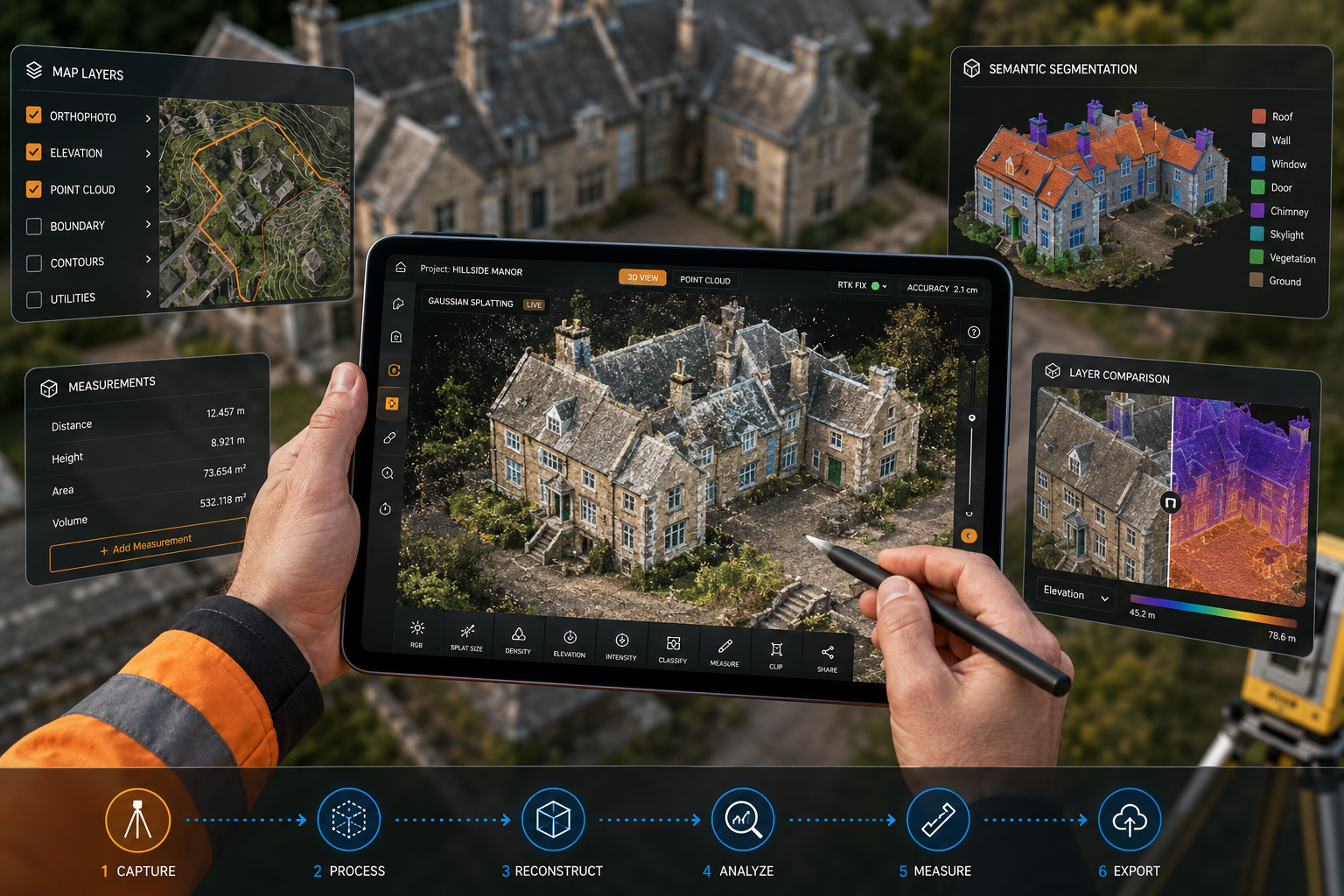
The numbers tell a clear story. MarketsandMarkets projected the mobile mapping market to reach USD 66.7 billion by 2026 at a 19.5% CAGR [5], while ResearchAndMarkets estimates the broader market reaching USD 116.45 billion by 2029 [3]. Polaris Market Research forecasts continued expansion through 2034, driven by 3D data collection for construction, real estate, and city-scale digital twins [7].
Three forces will shape the next five years:
-
Commoditisation of hardware — As LiDAR sensor costs continue to fall, handheld and backpack systems will become standard equipment for chartered surveyors, not specialist kit.
-
AI automation of post-processing — The bottleneck is shifting from capture to interpretation. AI pipelines that automatically classify, label, and report on captured geometry will determine which platforms dominate.
-
Regulatory and standards alignment — RICS and other professional bodies are beginning to develop guidance on how 3D capture data should be documented, stored, and used in formal survey reports. Surveyors who build compliant workflows now will have a significant advantage.
Academic research published in Sensors demonstrates complete mobile mapping pipelines that automatically extract and inventory 3D assets from continuous capture — a methodology directly applicable to building and property inventory at scale [9].
For property professionals looking to understand how these tools fit within the broader surveying landscape, exploring the full range of property survey options provides useful context on where technology-enhanced approaches complement traditional inspection methods.
Conclusion: Actionable Next Steps for Property Professionals in 2026
The advancements in mobile 3D mapping: creating detailed property models on the go represent one of the most significant shifts in property surveying practice in a generation. The barriers — cost, complexity, and bulk — are falling rapidly. What remains is the professional judgment to deploy these tools effectively.
Here is what to do next:
- Pilot one project — Select a mid-complexity property survey and use a handheld SLAM LiDAR device alongside your standard inspection. Compare the time investment and output quality.
- Evaluate two or three software platforms — Focus on GIS export capability, AI labelling features, and client-facing 3D viewer quality.
- Invest in GCP training — Ground control point placement is the single skill that most improves model accuracy for indoor–outdoor properties.
- Review RICS guidance — Check for updated professional standards on digital survey documentation before incorporating 3D models into formal reports.
- Communicate the value to clients — A navigable 3D property model is a tangible differentiator. Build it into your service proposition, not just your back-office workflow.
The surveyors who treat mobile 3D mapping as a core competency in 2026 — rather than a novelty — will be best positioned as the technology becomes the industry standard by the end of the decade.
References
[1] How 3D Mobile Mapping Is Changing The Landscape Of Project Management – https://www.apm.org.uk/blog/how-3d-mobile-mapping-is-changing-the-landscape-of-project-management/
[2] Watch (Mosaic: The Future of Mobile Mapping, AI & 3D Gaussian Splatting) – https://www.youtube.com/watch?v=vuGMDvm89qk
[3] Mobile Mapping Market Report – https://www.researchandmarkets.com/reports/5767236/mobile-mapping-market-report
[4] Best 3D Mapping Software – https://www.skyebrowse.com/news/posts/best-3d-mapping-software
[5] Mobile Mapping – https://www.marketsandmarkets.com/PressReleases/mobile-mapping.asp
[6] Top 9 Use Cases For Mobile Mapping In 2026 – https://www.oxts.com/top-9-use-cases-for-mobile-mapping-in-2026-2/
[7] Mobile Mapping Market – https://www.polarismarketresearch.com/industry-analysis/mobile-mapping-market
[8] Top Trends Transforming North America 3D Mobile Mapping Market – https://www.linkedin.com/pulse/top-trends-transforming-north-america-3d-mobile-mapping-market-hsore
[9] MDPI Sensors – Mobile Mapping System for Road Asset Inventory – https://www.mdpi.com/1424-8220/16/3/367
[10] Mobile Mapping System Market Industry – https://www.mordorintelligence.com/industry-reports/mobile-mapping-system-market-industry