}
The global race to build AI infrastructure has transformed the surveying profession overnight. As artificial intelligence workloads demand unprecedented computing power, data center construction is experiencing explosive growth that will reshape the built environment for decades to come. Surveyors now find themselves at the epicenter of a $3 trillion investment wave, where millimeter-level precision can mean the difference between project success and catastrophic failure.
Surveying for Data Center Developments: Meeting Precision Demands of the AI Infrastructure Boom in 2026 represents a fundamental shift in how professionals approach site assessment, utility mapping, and structural evaluation. With nearly 100 GW of new data center capacity planned between 2026 and 2030—effectively doubling global capacity—the surveying industry faces both unprecedented opportunity and technical challenges that demand specialized expertise.[1]
This transformation isn't just about scale. Modern AI data centers require hyperscale site assessments that account for massive power consumption, cooling infrastructure, seismic resilience, and underground utility networks far more complex than traditional commercial developments. The stakes have never been higher, and the technical demands have never been more exacting.
Key Takeaways
- Global data center capacity will double by 2030, with $3 trillion in projected spending creating massive demand for specialized surveying services across greenfield and brownfield developments.[1][2]
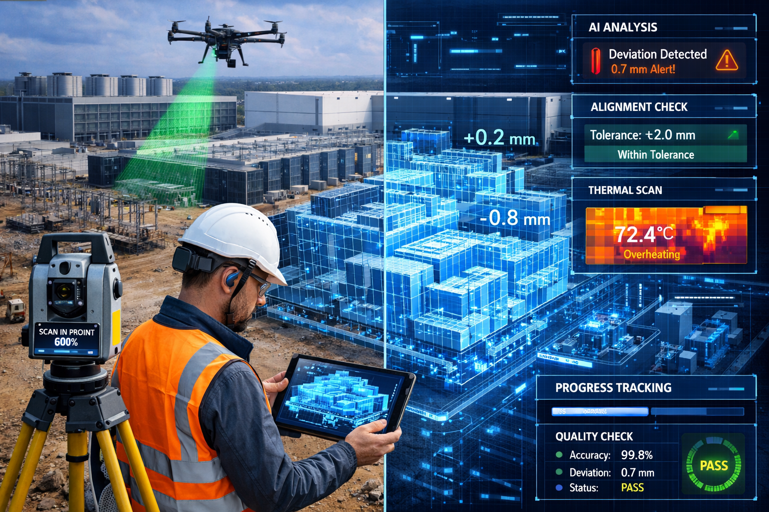
- Precision tolerances of ±2mm are now standard for data center foundation work, requiring advanced total station equipment, laser scanning, and GPS technology far beyond conventional commercial surveying.
- Underground utility mapping has become critical as data centers require extensive fiber optic networks, redundant power connections, and cooling infrastructure that must be precisely documented to avoid costly construction delays.
- Seismic resilience evaluations are mandatory for data center developments, with surveyors conducting detailed geotechnical assessments, soil stratification analysis, and foundation monitoring to ensure structural integrity.
- Digital twin technology and BIM integration are revolutionizing surveying workflows, enabling real-time collaboration, automated quality control, and accelerated construction timelines essential for competitive deployment.[3]
Understanding the AI Infrastructure Boom Driving Data Center Expansion
The Scale of Investment and Growth Projections
The numbers behind the AI infrastructure boom are staggering. Data centers captured more than one-fifth of global greenfield investment in 2025, demonstrating an unprecedented capital reallocation toward computing infrastructure.[9] This investment surge translates to approximately $1.2 trillion in real estate asset value creation and an additional $1-2 trillion in IT equipment fitouts over the next five years.[1]
Regional growth patterns reveal where surveying opportunities will concentrate:
| Region | Current Capacity | 2030 Projected Capacity | Growth Rate (CAGR) |
|---|---|---|---|
| APAC | 32 GW | 57 GW | 12% |
| EMEA | Current baseline | +13 GW new supply | 10% |
| Americas | Dominant share | Continued expansion | 14%+ |
The Asia-Pacific region shows particularly dynamic growth, with colocation facilities expanding at 19% annually while on-premises capacity declines by 6%.[1] This shift toward colocation and hyperscale facilities creates distinct surveying requirements compared to traditional enterprise data centers.
Why AI Workloads Demand Different Infrastructure
Traditional data centers and AI-focused facilities operate under fundamentally different constraints. AI workloads require:
- ⚡ Higher power density – GPU clusters consume 3-5x more electricity per rack than traditional servers
- 🌡️ Advanced cooling systems – Liquid cooling and immersion cooling technologies require precise spatial planning
- 📡 Ultra-low latency networking – Fiber optic infrastructure must be surveyed and installed with exceptional accuracy
- 🔋 Redundant power systems – Multiple utility connections, backup generators, and battery systems demand complex site coordination
These requirements directly impact surveying scope and methodology. A RICS commercial building survey for a data center must account for load-bearing requirements that far exceed typical commercial structures, while underground utility surveys must map increasingly dense infrastructure networks.
Accelerated Timelines and Construction Pressures
Time to market is directly linked to revenue capture in the competitive AI infrastructure landscape.[3] Hyperscalers and colocation providers face intense pressure to deploy capacity quickly, creating cascading demands on the surveying profession:
- 📊 Standardized reference designs significantly reduce planning stages, allowing surveyors to work from proven templates rather than custom specifications[5]
- 🏗️ Modular construction approaches require precise site preparation and foundation work to accommodate prefabricated components
- 🔄 Digital twins and offsite fabrication treat construction sites like factories, demanding surveying accuracy that supports platform-based designs[3]
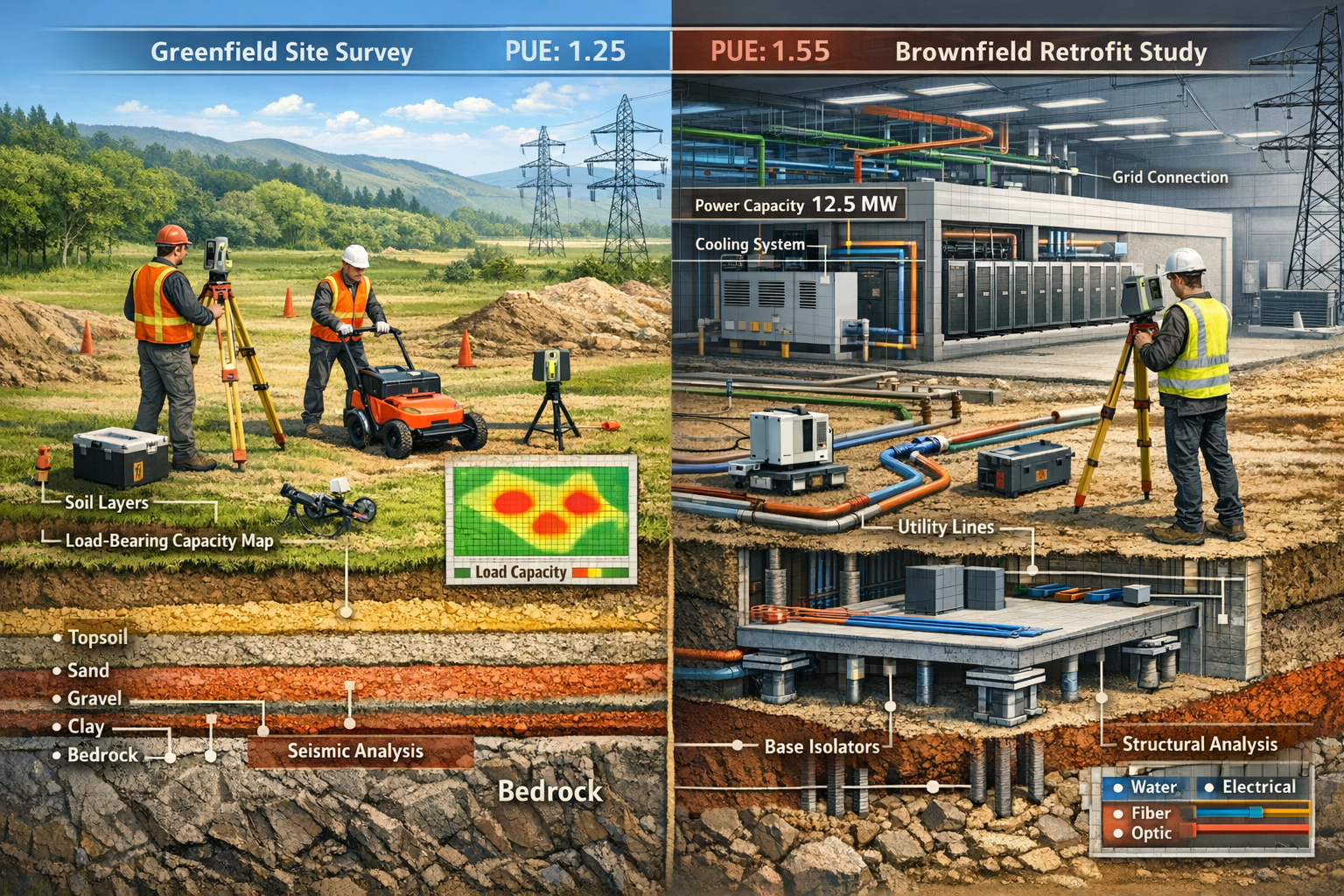
The shift toward brownfield datacenter retrofits adds another dimension to surveying work. Converting existing industrial facilities, warehouses, or inefficient legacy data centers offers faster deployment than greenfield builds, but requires comprehensive structural surveys to assess retrofit viability and identify hidden challenges.[5]
Surveying for Data Center Developments: Precision Requirements and Technical Challenges
Foundation and Structural Tolerance Standards
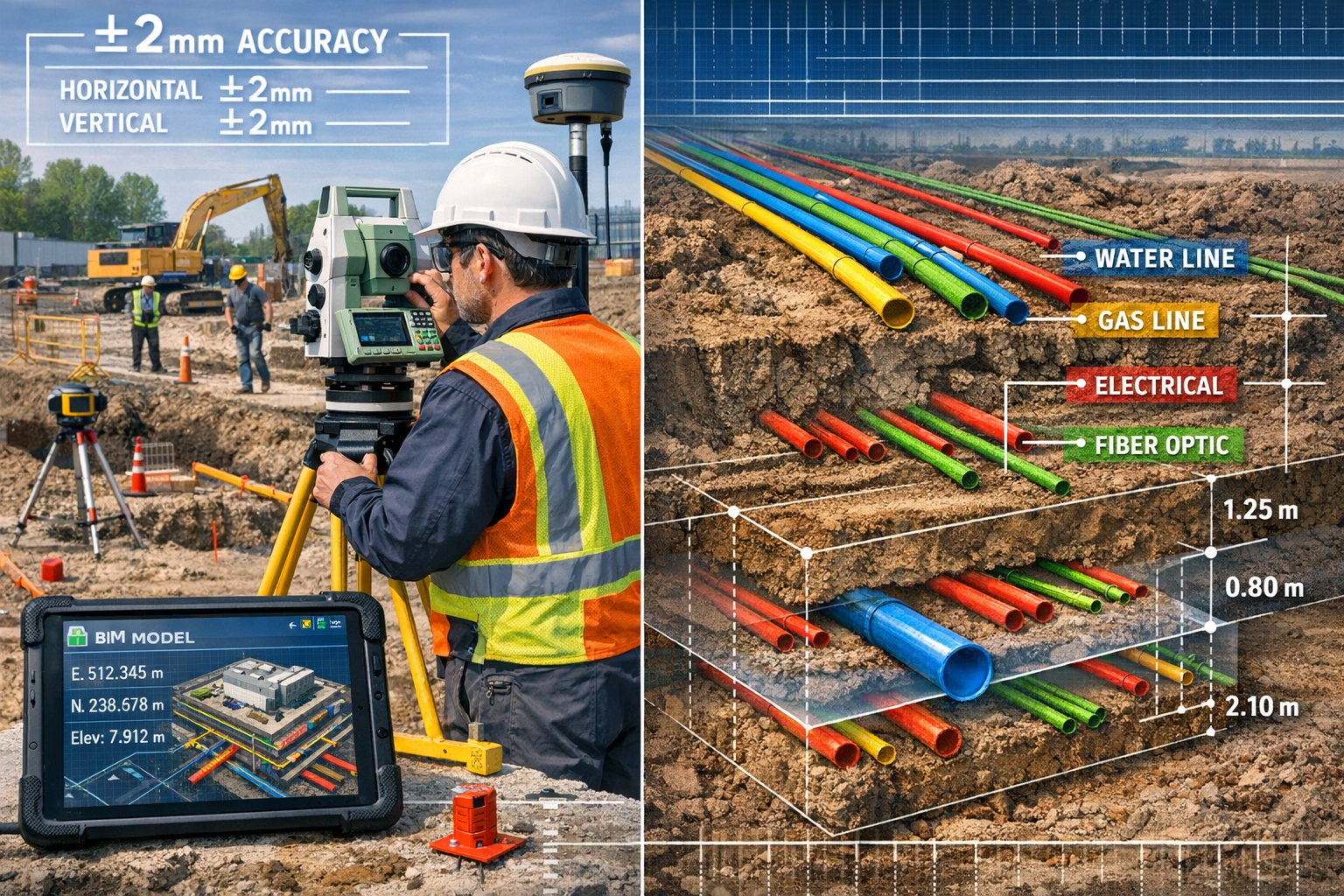
Data center foundations demand precision that exceeds virtually all other commercial construction categories. While typical commercial buildings might accept tolerances of ±10-15mm, AI data centers require ±2mm accuracy for raised floor systems that support densely packed server racks weighing thousands of pounds per square foot.
Key structural surveying considerations include:
- 📏 Floor flatness specifications – FF/FL (Floor Flatness/Floor Levelness) numbers must meet or exceed FF100/FL50 for critical areas
- ⚖️ Load-bearing capacity verification – Point loads from server racks can exceed 2,000 pounds per square foot
- 🔍 Settlement monitoring – Long-term foundation monitoring ensures structural integrity as facilities scale
- 🏛️ Column placement precision – Support columns must align with modular rack layouts to optimize space utilization
Professional surveyors working on data center projects typically deploy robotic total stations with automated target recognition, enabling continuous monitoring throughout construction phases. This equipment captures millions of measurement points, creating comprehensive as-built documentation that feeds directly into Building Information Modeling (BIM) systems.
The structural engineering discipline intersects heavily with surveying during data center development. Engineers rely on survey data to validate structural calculations, verify installation accuracy, and certify that constructed elements meet design specifications.
Underground Utility Mapping and Coordination
Perhaps no aspect of Surveying for Data Center Developments: Meeting Precision Demands of the AI Infrastructure Boom in 2026 presents greater complexity than underground utility coordination. Modern AI data centers require:
Power Infrastructure:
- 🔌 Multiple redundant utility connections (often 50+ MW capacity)
- ⚡ On-site substations and transformer yards
- 🔋 Underground electrical conduit networks
- 🔄 Backup generator fuel lines and distribution systems
Cooling and Water Systems:
- 💧 Chilled water supply and return lines
- 🌊 Stormwater management and drainage
- ♨️ Heat rejection infrastructure
- 💦 Fire suppression water mains
Network Connectivity:
- 📡 Multiple fiber optic pathways for redundancy
- 🌐 Diverse carrier entry points
- 📶 Internal campus fiber networks
- 🔗 Cross-connect infrastructure
Advanced surveying techniques for utility mapping include:
- Ground-Penetrating Radar (GPR) – Non-destructive subsurface imaging that identifies existing utilities, voids, and soil conditions
- Electromagnetic Location (EML) – Traces active electrical lines and metallic pipes with precision
- Vacuum Excavation – Confirms utility locations identified through remote sensing before major excavation
- 3D Subsurface Modeling – Creates comprehensive digital representations of underground infrastructure
The consequences of utility strikes during data center construction are severe. A single fiber cut can delay project completion by weeks and cost millions in lost revenue. Professional surveyors must therefore maintain comprehensive utility databases that document every known subsurface element with spatial accuracy sufficient for safe excavation planning.
Understanding different types of survey becomes essential when scoping data center projects, as multiple specialized survey types may be required throughout the development lifecycle.
Seismic and Geotechnical Evaluation Requirements
Seismic resilience has become non-negotiable for data center developments, particularly in regions with active fault lines or seismic risk. The continuous operation requirements of AI infrastructure mean that facilities must remain functional even during significant seismic events.
Surveying professionals contribute to seismic evaluation through:
Site Characterization:
- 🌍 Detailed topographic mapping identifying slope stability risks
- 🪨 Bedrock depth determination through geophysical surveys
- 📊 Soil stratification analysis using test boring coordination
- 💧 Groundwater level monitoring and seasonal variation tracking
Foundation Monitoring:
- 📐 Baseline elevation surveys establishing reference points
- 🔄 Periodic resurveys detecting settlement or movement
- 📡 Automated monitoring systems providing real-time alerts
- 📈 Long-term trend analysis identifying structural concerns
Seismic Instrumentation Support:
- 🎯 Precise placement surveying for seismic sensors
- 🔧 Alignment verification for base isolation systems
- 📏 Clearance verification for seismic gaps and joints
- ✅ Post-earthquake damage assessment surveys
The integration of monitoring surveys into data center operations provides ongoing assurance that facilities maintain structural integrity throughout their operational lifespan. These surveys detect subtle movements that might indicate foundation issues, soil consolidation, or seismic effects before they become critical problems.
Surveying for Data Center Developments: Specialized Methodologies and Technology Integration
Laser Scanning and Point Cloud Technology
3D laser scanning has revolutionized how surveyors document existing conditions and verify construction accuracy for data center developments. Modern terrestrial laser scanners capture millions of measurement points per second, creating dense point clouds that represent physical reality with unprecedented detail.
Applications in data center surveying include:
- 🏗️ As-built documentation – Capturing complete facility geometry for BIM integration
- 🔍 Quality control verification – Comparing constructed elements against design models
- 📦 Space planning optimization – Analyzing clearances for equipment installation
- 🔄 Retrofit assessment – Documenting existing facilities for brownfield conversions
- 🎯 MEP coordination – Verifying mechanical, electrical, and plumbing installations
The workflow typically involves:
- Field scanning – Deploying laser scanners at strategic locations throughout the facility
- Point cloud registration – Combining multiple scans into unified coordinate systems
- Data processing – Filtering noise, classifying elements, and extracting measurements
- BIM integration – Converting point clouds into intelligent 3D models
- Deliverable creation – Producing drawings, reports, and digital twins
Scan-to-BIM workflows enable construction teams to identify conflicts before they occur. When a mechanical contractor plans to install cooling infrastructure, the point cloud reveals exactly where existing structural elements, electrical conduits, and other systems are located—preventing costly rework and schedule delays.
GPS and GNSS for Large-Scale Site Control
Data center campuses often span hundreds of acres, requiring survey control networks that maintain accuracy across vast distances. Global Navigation Satellite Systems (GNSS) provide the foundation for these networks, enabling surveyors to establish precise reference points that guide all subsequent construction activities.
Key GNSS applications include:
- 🛰️ Primary control point establishment – Creating site-wide reference networks
- 📍 Building corner stakeout – Marking foundation locations with centimeter accuracy
- 🚧 Grading verification – Confirming earthwork meets design elevations
- 🔌 Utility corridor layout – Establishing trenching alignments for underground infrastructure
- 📡 Real-time kinematic (RTK) positioning – Providing instant corrections for construction equipment
Modern RTK GNSS systems achieve horizontal accuracies of ±8mm and vertical accuracies of ±15mm under optimal conditions. When combined with local base stations or network RTK services, surveyors can maintain this precision across entire data center campuses without traditional traverse networks.
The challenge in 2026 is that grid constraints and power connection waitlists are prompting developers to seek alternative locations, sometimes in areas with limited GNSS infrastructure.[8] Professional surveyors must therefore be prepared to establish autonomous positioning solutions using total stations, levels, and conventional surveying techniques when satellite-based systems prove inadequate.
Building Information Modeling (BIM) Integration
Digital twins are reducing construction risk and enabling higher-quality builds by creating virtual replicas of physical facilities.[3] For surveyors, BIM integration means their field measurements directly populate intelligent 3D models that all project stakeholders can access and update in real-time.
BIM workflows for data center surveying:
📋 Pre-Construction Phase:
- Import design models into survey software
- Establish coordinate systems matching project requirements
- Generate stakeout lists for foundation elements
- Create clash detection reports identifying design conflicts
🏗️ Construction Phase:
- Conduct as-built surveys of installed elements
- Compare field measurements against design intent
- Update BIM models with actual conditions
- Generate deviation reports for quality control
✅ Post-Construction Phase:
- Deliver comprehensive as-built BIM models
- Document all underground utilities in 3D
- Create facility management databases
- Establish baseline for future expansion surveys
The standardized reference designs now common in AI datacenter construction rely heavily on BIM coordination.[5] When developers use proven templates, surveyors can work from established BIM models rather than interpreting 2D drawings, dramatically reducing the potential for misinterpretation and error.
For surveyors seeking to expand into data center work, understanding commercial building surveys provides essential context for how these large-scale projects differ from residential or small commercial developments.
Drone Surveys and Aerial Photogrammetry
Unmanned Aerial Systems (UAS) have become indispensable tools for data center site assessment and construction monitoring. Drones equipped with high-resolution cameras and LiDAR sensors can survey hundreds of acres in hours, producing deliverables that would require weeks of conventional ground-based work.
Drone applications in data center surveying:
- 🗺️ Topographic mapping – Creating detailed elevation models for site planning
- 📸 Progress documentation – Capturing weekly aerial imagery tracking construction advancement
- 📊 Volumetric calculations – Measuring earthwork quantities for cut/fill operations
- 🔍 Inspection access – Examining roof-mounted cooling equipment and electrical infrastructure
- 🌡️ Thermal imaging – Identifying heat loss and equipment inefficiencies
Photogrammetry workflows process hundreds or thousands of overlapping aerial images to create:
- 📐 Orthomosaic maps – Geometrically corrected aerial photographs suitable for measurement
- 🏔️ Digital elevation models (DEMs) – Representing terrain surfaces with centimeter accuracy
- 🏗️ 3D mesh models – Visualizing existing conditions and construction progress
The regulatory environment for commercial drone operations continues to evolve in 2026, with most jurisdictions requiring licensed pilots and specific operational approvals for flights near critical infrastructure. Professional surveyors must navigate these requirements while maintaining the rapid deployment schedules that data center projects demand.
Those interested in expanding their aerial surveying capabilities should explore drone surveys as a specialized service offering that complements traditional ground-based techniques.
Case Studies: Surveying Challenges in Real Data Center Projects
Hyperscale Greenfield Development: Power and Precision
A major hyperscaler recently broke ground on a 50 MW AI training facility in the American Southwest. The project exemplifies the surveying challenges inherent in greenfield data center developments at unprecedented scale.
Project Parameters:
- 📏 Site area: 85 acres
- ⚡ Power capacity: 50 MW initial, 150 MW ultimate
- 🏗️ Building footprint: 450,000 square feet
- 🔌 Utility connections: 4 redundant grid feeds
Surveying Scope and Challenges:
The surveying team faced several critical requirements:
-
Site Control Network – Establishing a GPS-based control network with 12 primary monuments spaced across the campus, achieving ±5mm horizontal accuracy despite challenging atmospheric conditions in the desert environment.
-
Grading Verification – Moving 2.3 million cubic yards of earth required continuous surveying support. The team deployed machine control systems on excavators and dozers, enabling operators to achieve ±0.05-foot vertical accuracy without traditional grade stakes.
-
Foundation Precision – The raised floor system required floor flatness of FF100/FL50 across 450,000 square feet. Surveyors conducted laser level surveys at 5-foot intervals, identifying and correcting deviations before concrete placement.
-
Utility Coordination – Mapping 47 miles of underground conduit, including:
- 23 miles of electrical conduit (multiple voltage levels)
- 12 miles of chilled water piping
- 8 miles of fiber optic pathways
- 4 miles of natural gas distribution
Innovative Solutions:
The surveying firm implemented automated monitoring systems using robotic total stations that tracked foundation settlement during construction. These instruments captured measurements every 4 hours, alerting the team to any movement exceeding ±1mm. This proactive approach prevented costly rework and ensured the facility met structural specifications.
The project also pioneered real-time BIM updates where field surveyors uploaded as-built measurements directly to cloud-based models accessible to all contractors. This eliminated the traditional lag between field work and drawing updates, reducing coordination conflicts by an estimated 60%.
Brownfield Retrofit: Converting Industrial Space to AI Infrastructure
A colocation provider acquired a former automotive manufacturing facility for conversion into a 25 MW AI-focused data center. This brownfield retrofit presented surveying challenges distinct from greenfield development.
Existing Conditions:
- 🏭 1970s-era industrial building
- 📐 600,000 square feet of manufacturing space
- ⚡ Existing 15 MW electrical service
- 🔧 Legacy mechanical systems and utilities
Surveying Challenges:
Structural Assessment:
The surveying team conducted comprehensive structural surveys to determine load-bearing capacity. Using a combination of ground-penetrating radar and core sampling coordination, they mapped:
- Foundation thickness and reinforcement patterns
- Column spacing and load capacity
- Floor slab condition and flatness
- Roof structure and support systems
Hidden Utility Discovery:
Unlike greenfield sites with clean slates, the brownfield location contained decades of undocumented modifications. The survey team employed:
- 🔍 Ground-penetrating radar scans covering 100% of the floor area
- 📡 Electromagnetic utility location for active services
- 🕳️ Strategic vacuum excavation confirming suspected utility locations
- 📋 Creation of comprehensive as-built utility databases
Results and Lessons:
The brownfield approach reduced time-to-market by 8 months compared to equivalent greenfield development, leveraging existing permits, utility infrastructure, and network access.[5] However, surveying costs were approximately 40% higher than greenfield equivalents due to the complexity of documenting existing conditions and working around operational constraints.
The project demonstrated that retrofitting existing inefficient datacenters unlocks extra compute capacity while reducing overhead costs, particularly when existing locations run at high Power Usage Effectiveness (PUE) levels.[5]
Seismic Zone Data Center: Resilience Through Precision
A financial services firm commissioned a Tier IV data center in a high-seismic-risk zone, requiring extraordinary attention to foundation design and monitoring. The surveying scope extended far beyond typical commercial work.
Seismic Design Requirements:
- 🌍 Site Class D soil conditions
- 📊 Design basis earthquake: 0.6g peak ground acceleration
- 🏗️ Base isolation system with 18-inch lateral displacement capacity
- 📡 Continuous structural health monitoring
Specialized Surveying Services:
Geotechnical Support:
Surveyors coordinated placement of 45 test borings across the site, establishing precise locations for geotechnical engineers to analyze soil stratification, liquefaction potential, and bearing capacity. GPS coordinates accurate to ±10mm ensured boring data could be correctly positioned in 3D geological models.
Base Isolation Monitoring:
The facility's seismic base isolation system required:
- 📏 Baseline surveys establishing neutral positions for all 64 isolators
- 🔄 Quarterly monitoring detecting any pre-stress loss or movement
- 📐 Clearance verification ensuring 18-inch seismic gaps remained unobstructed
- ⚠️ Automated alert systems triggering if movement exceeded ±2mm
Long-Term Performance:
Three years post-construction, the monitoring program detected subtle settlement in one building quadrant. Early identification allowed engineers to implement corrective measures before any operational impact occurred, demonstrating the value of continuous surveying support.
This case study illustrates why monitoring surveys have become standard practice for mission-critical data center infrastructure, providing early warning of structural issues that could compromise availability.
Surveying for Data Center Developments: Professional Development and Market Opportunities
Skills and Certifications Required
The specialized nature of Surveying for Data Center Developments: Meeting Precision Demands of the AI Infrastructure Boom in 2026 requires surveyors to develop competencies beyond traditional commercial construction experience.
Essential Technical Skills:
📐 Advanced Instrumentation:
- Robotic total station operation and programming
- 3D laser scanning and point cloud processing
- RTK GNSS setup and network configuration
- Ground-penetrating radar interpretation
- Drone piloting and photogrammetry processing
💻 Software Proficiency:
- BIM platforms (Revit, Navisworks, AutoCAD Civil 3D)
- Point cloud processing (ReCap, CloudCompare, Leica Cyclone)
- Survey data collectors and field software
- GIS platforms for utility mapping
- 3D modeling and visualization tools
🏗️ Domain Knowledge:
- Data center electrical systems and power distribution
- Cooling infrastructure and mechanical systems
- Fiber optic network design and installation
- Seismic design principles and base isolation
- Construction sequencing and scheduling
Professional Certifications:
Surveyors pursuing data center specialization should consider:
- ✅ Professional Land Surveyor (PLS) – State licensure requirements
- ✅ LEED Accreditation – Understanding sustainable design principles
- ✅ Part 107 Remote Pilot Certificate – Legal drone operation
- ✅ BIM Certifications – Autodesk or Bentley platform credentials
- ✅ OSHA Safety Training – Construction site safety compliance
The intersection with chartered surveyors in London and other major metropolitan areas reflects how data center development concentrates in regions with robust power infrastructure and network connectivity, creating geographic hotspots for specialized surveying work.
Market Positioning and Business Development
With $3 trillion in global spending projected over five years, surveyors who position themselves as data center specialists can capture significant market share in this high-value sector.[2]
Effective Marketing Strategies:
🎯 Niche Specialization:
Rather than competing as generalist surveyors, firms should develop recognized expertise in data center work. This includes:
- Creating case studies documenting successful projects
- Publishing technical articles on surveying challenges and solutions
- Speaking at data center industry conferences
- Developing relationships with specialized contractors and engineers
💼 Strategic Partnerships:
Data center projects involve complex teams. Surveyors should build relationships with:
- Mechanical, electrical, and plumbing (MEP) engineers
- Structural engineers specializing in seismic design
- General contractors focused on data center construction
- Developers and hyperscalers planning facility expansions
- Colocation providers managing portfolio growth
📊 Service Diversification:
Beyond initial construction surveying, firms can offer:
- Pre-acquisition due diligence – Assessing sites for development potential
- Ongoing monitoring programs – Continuous structural health tracking
- Expansion planning surveys – Supporting phased capacity additions
- Decommissioning surveys – Documenting equipment removal and space reconfiguration
The regional concentration of data center development creates opportunities for surveyors in specific markets. Those working with chartered surveyors in Surrey or chartered surveyors in Essex may find themselves near emerging data center corridors as developers seek locations with available power capacity and network connectivity.
Emerging Technologies and Future Trends
The surveying profession continues to evolve rapidly, with several technologies poised to transform data center development workflows in the coming years.
Artificial Intelligence and Machine Learning:
🤖 Automated Feature Extraction:
AI algorithms can process point cloud data to automatically identify and classify building elements, utilities, and equipment—reducing manual processing time by 70-80%.
📊 Predictive Analytics:
Machine learning models analyze historical survey data to predict settlement patterns, identify high-risk areas, and optimize monitoring intervals.
🔍 Quality Control Automation:
AI-powered systems compare as-built surveys against design models, automatically flagging deviations that exceed tolerance thresholds and generating exception reports.
Augmented Reality (AR) Integration:
👓 Field Visualization:
Surveyors wearing AR headsets can see design models overlaid on physical reality, enabling real-time verification that installations match specifications.
📍 Utility Location Display:
Underground utilities mapped through GPR and electromagnetic location appear as virtual overlays, helping excavation crews avoid strikes.
🎯 Stakeout Guidance:
AR systems guide surveyors to precise locations for setting control points, eliminating the need for traditional stakeout calculations.
Autonomous Surveying Systems:
🤖 Robotic Platforms:
Mobile robots equipped with laser scanners autonomously navigate construction sites, capturing comprehensive as-built data without human intervention.
🚁 Automated Drone Flights:
Pre-programmed flight paths enable drones to conduct weekly progress surveys with consistent coverage and resolution.
📡 Continuous Monitoring Networks:
Permanently installed sensors track foundation movement, structural deflection, and environmental conditions 24/7, alerting surveyors to anomalies.
These technological advances will further differentiate surveyors who invest in cutting-edge capabilities from those relying on traditional methods. The accelerated construction timelines now standard in data center development demand tools that deliver faster, more accurate results.[3]
Regulatory Compliance and Quality Assurance in Data Center Surveying
Industry Standards and Best Practices
Data center surveying operates under multiple overlapping standards frameworks, each addressing different aspects of quality and performance.
Key Standards Include:
📋 ANSI/TIA-942 – Telecommunications Infrastructure Standard for Data Centers
- Defines site selection criteria
- Establishes architectural and structural requirements
- Specifies mechanical and electrical standards
- Outlines telecommunications infrastructure
🏗️ ASTM E1155 – Standard Test Method for Determining FF Floor Flatness and FL Floor Levelness Numbers
- Establishes measurement protocols for floor surfaces
- Defines acceptance criteria for different use cases
- Specifies equipment calibration requirements
⚡ Uptime Institute Tier Standards – Facility reliability classifications
- Tier I: Basic capacity (99.671% availability)
- Tier II: Redundant components (99.741% availability)
- Tier III: Concurrently maintainable (99.982% availability)
- Tier IV: Fault tolerant (99.995% availability)
Each tier level imposes different surveying requirements, with Tier IV facilities demanding the most rigorous documentation and monitoring.
Quality Assurance Protocols:
Surveyors working on data center projects should implement:
✅ Calibration Management:
- Daily equipment checks before field work
- Annual certified calibrations for all instruments
- Documented calibration records maintained throughout project lifecycle
✅ Redundant Measurements:
- Critical points measured with multiple instruments
- Independent verification of foundation elevations
- Cross-checking between GPS and conventional methods
✅ Documentation Standards:
- Comprehensive field notes with sketches
- Digital photographs georeferenced to survey points
- Metadata tracking instrument used, operator, date, and conditions
✅ Peer Review:
- Senior surveyor review of all deliverables
- Third-party verification for critical elements
- Regular project meetings with design team
The importance of schedule of condition reports extends to data center work, particularly when documenting existing conditions before retrofit projects or establishing baseline conditions for long-term monitoring programs.
Environmental and Sustainability Considerations
The data center industry faces increasing scrutiny over environmental impact, particularly energy consumption and carbon emissions. Grid constraints and renewable energy targets are driving significant changes in how facilities are powered and cooled.[3]
Surveying's Role in Sustainability:
🌱 Renewable Energy Integration:
Surveyors support installation of on-site renewable generation through:
- Solar array layout and grading verification
- Wind turbine foundation surveys
- Battery storage facility positioning
- Electrical interconnection routing
💧 Water Conservation:
Water-cooled data centers require:
- Cooling tower placement surveys
- Water supply and discharge line mapping
- Stormwater management system verification
- Groundwater monitoring well positioning
♻️ Adaptive Reuse:
Brownfield retrofits reduce environmental impact by:
- Preserving existing structures and foundations
- Reusing utility infrastructure where feasible
- Minimizing new impervious surfaces
- Avoiding greenfield habitat disruption
LEED Certification Support:
Many data centers pursue Leadership in Energy and Environmental Design (LEED) certification. Surveyors contribute through:
- 📐 Documenting sustainable site development practices
- 🌳 Verifying preservation of required open space
- 🚗 Confirming alternative transportation infrastructure
- 💡 Supporting energy modeling with accurate as-built data
The resurgence in natural gas for data center power reflects the tension between renewable targets and deployment speed.[3] Surveyors must be prepared to support hybrid energy solutions combining renewables, grid power, and on-site generation—each with distinct infrastructure requirements.
Risk Management and Professional Liability
The high-stakes nature of data center development amplifies the consequences of surveying errors. A foundation misplacement of even a few centimeters can cascade into millions of dollars in rework and schedule delays.
Risk Mitigation Strategies:
🛡️ Professional Liability Insurance:
- Maintain coverage limits appropriate to project values
- Ensure policies cover technology-specific risks (laser scanning, drone operations)
- Document all exclusions and limitations
- Consider project-specific insurance for major developments
📋 Contractual Protections:
- Clear scope of work definitions
- Explicit accuracy standards and tolerances
- Defined deliverable formats and schedules
- Limitation of liability clauses where appropriate
🔍 Quality Control Processes:
- Multi-level review of all deliverables
- Independent verification of critical measurements
- Documented procedures for error detection and correction
- Regular training on equipment and software updates
⚠️ Communication Protocols:
- Immediate notification of discovered discrepancies
- Written documentation of field conditions
- Regular coordination meetings with design team
- Clear escalation paths for technical issues
Understanding the broader context of surveys helps professionals appreciate how data center work fits within the surveying discipline while recognizing its unique demands and risk profile.
Conclusion: Positioning for Success in the Data Center Surveying Market
The explosive growth in Surveying for Data Center Developments: Meeting Precision Demands of the AI Infrastructure Boom in 2026 represents a generational opportunity for surveying professionals. With nearly 100 GW of new capacity planned globally and $3 trillion in investment flowing into AI infrastructure, the demand for specialized surveying expertise will only intensify in the coming years.[1][2]
Success in this market requires:
🎯 Technical Excellence – Mastering advanced instrumentation, software platforms, and methodologies specific to data center construction
🤝 Strategic Relationships – Building partnerships with developers, contractors, and engineering firms active in the sector
📚 Continuous Learning – Staying current with evolving technologies, standards, and best practices as the industry matures
🌍 Geographic Positioning – Locating practices near emerging data center corridors with available power and connectivity
The precision demands of AI infrastructure—from ±2mm foundation tolerances to comprehensive underground utility mapping to continuous seismic monitoring—have elevated surveying from a commodity service to a critical success factor. Projects cannot proceed without accurate survey data, and the accelerated timelines now standard in the industry mean that surveying delays directly impact revenue capture.
Actionable Next Steps
For surveying professionals seeking to capitalize on the data center boom:
Immediate Actions (Next 30 Days):
- 📖 Review ANSI/TIA-942 and Uptime Institute standards to understand facility requirements
- 🔍 Research data center projects planned in your geographic market
- 💼 Identify potential partners among MEP engineers and specialized contractors
- 🎓 Assess skill gaps in your team and identify training opportunities
Short-Term Initiatives (Next 90 Days):
- 🤖 Invest in advanced surveying technology (laser scanning, RTK GNSS, or drone systems)
- 📊 Develop case studies from any existing commercial work that demonstrates relevant capabilities
- 🌐 Attend data center industry conferences to build relationships and market knowledge
- 📝 Create marketing materials positioning your firm as a data center specialist
Long-Term Strategy (Next 12 Months):
- 🎯 Complete at least one data center project to establish credibility and develop internal expertise
- 🏆 Pursue relevant certifications (BIM, LEED, or specialized training programs)
- 📈 Build a portfolio of data center work that can be showcased to prospective clients
- 🔄 Establish ongoing monitoring service offerings for recurring revenue opportunities
The AI infrastructure boom is not a temporary phenomenon. As artificial intelligence becomes increasingly central to business operations, scientific research, and everyday life, the computing infrastructure supporting these workloads will continue expanding for decades. Surveyors who position themselves now as data center specialists will be well-placed to capture market share in one of the construction industry's fastest-growing sectors.
The precision demands are exacting. The technical challenges are substantial. The stakes are high. But for surveying professionals willing to invest in specialized capabilities and domain knowledge, Surveying for Data Center Developments: Meeting Precision Demands of the AI Infrastructure Boom in 2026 offers unprecedented opportunity to build thriving practices serving mission-critical infrastructure that powers the digital economy.
References
[1] Data Center Outlook – https://www.jll.com/en-us/insights/market-outlook/data-center-outlook
[2] constructiondive – https://www.constructiondive.com/news/data-centers-construction-2026-trends/810016/
[3] Data Centre Trends 2026 Shifting Up Gear – https://www.accenture.com/us-en/insights/infrastructure-capital-projects/data-centre-trends-2026-shifting-up-gear
[4] Data Center Industry Trends – https://www.tierpoint.com/blog/data-center/data-center-industry-trends/
[5] Ai Datacenter Trends Shaping 2026 – https://submer.com/blog/ai-datacenter-trends-shaping-2026/
[6] Data Center Trends 2026 10 Key Predictions Every It Leader Should Know – https://www.databank.com/resources/blogs/data-center-trends-2026-10-key-predictions-every-it-leader-should-know/
[7] Five Trends In Ai Infrastructure For 2026 – https://www.datacenterdynamics.com/en/opinions/five-trends-in-ai-infrastructure-for-2026/
[8] 7 Data Center Trends To Watch In 2026 – https://serverlift.com/cs/blog/7-data-center-trends-to-watch-in-2026/
[9] Data Centres Are Reshaping Global Investment Landscape – https://unctad.org/news/data-centres-are-reshaping-global-investment-landscape
[10] New Data Center Developments January 2026 – https://www.datacenterknowledge.com/data-center-construction/new-data-center-developments-january-2026