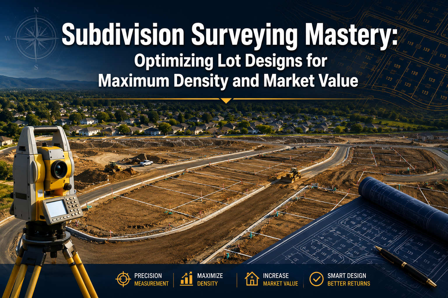
A single poorly drawn lot boundary can cost a developer hundreds of thousands of dollars in lost yield. With housing shortages tightening across major markets in 2026, surveyors who understand how to squeeze maximum density from a parcel while protecting market value have become among the most sought-after professionals in the development pipeline.
Subdivision surveying mastery: optimizing lot designs for maximum density and market value is no longer a niche skill set. It sits at the intersection of technical precision, zoning intelligence, and financial modeling. Developers are actively seeking surveyors who can deliver value-add reporting, navigate zoning classifications strategically, and design utility platting that keeps infrastructure costs under control.
Key Takeaways
- Lot development costs vary dramatically based on topography and infrastructure proximity, ranging from $24,000 to $65,000 per lot depending on site conditions [1][2]
- Zoning classification is one of the most powerful levers for increasing land value before a single stake is driven
- Compact road layouts and strategic utility routing can eliminate thousands of dollars per lot in infrastructure expense [3]
- Residual land value modeling helps developers and surveyors align lot yield targets with realistic profit margins [5]
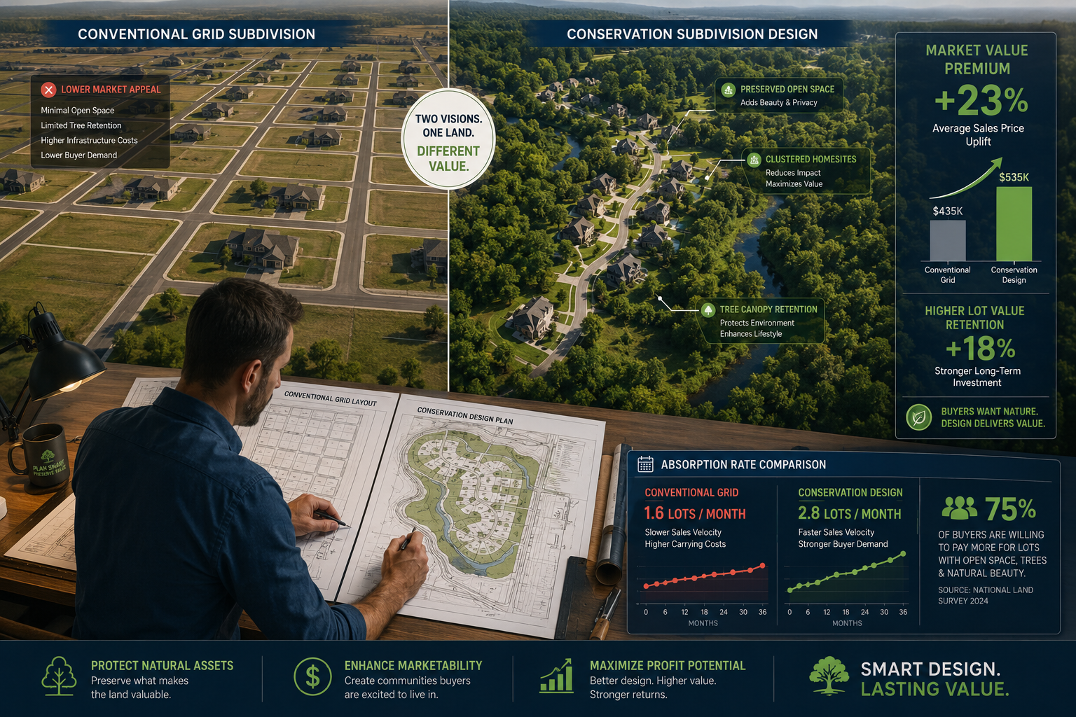
- Conservation subdivision designs can command price premiums and faster absorption rates compared to conventional layouts [7]
Why Surveyors Are Now Central to Development Profitability
Housing shortages across the UK, US, and Australia have shifted developer priorities. Speed to market matters, but so does yield per acre. A surveyor who simply draws boundaries is no longer sufficient. Developers need professionals who understand how every design decision affects the bottom line.
The financial stakes are significant. In Sun Belt markets, lot development costs for a 38-lot subdivision range from $40,000 to $65,000 per lot. Flat sites near existing utilities can come in as low as $42,000, while sites with steep grade changes or requiring off-site sewer extensions can push costs to $65,000 per lot [1]. In Central New York, a 50-lot residential subdivision carries site development costs of $1.2 million to $2.8 million before foundation work, averaging $24,000 to $56,000 per lot [2].
These figures demonstrate a clear truth: the surveyor's design choices directly determine whether a project is profitable or marginal.
The surveyor's expanded role now includes:
- Feasibility analysis before planning applications are submitted
- Zoning classification review and upzoning opportunity identification
- Lot yield optimization relative to infrastructure routing
- Value-add reporting for lenders, planners, and development partners
- Coordination with structural and drainage engineers
For developers working with local chartered surveyors, the expectation is increasingly that the surveyor brings strategic insight, not just technical compliance.
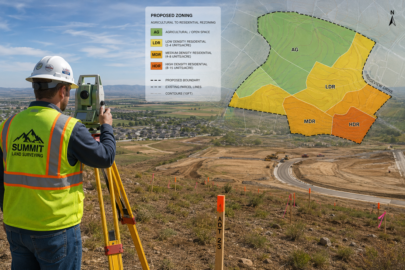
Zoning Intelligence: The First Layer of Subdivision Surveying Mastery
Before any site is platted, zoning classification determines what is legally possible. Agricultural zoning typically restricts development to very low densities, sometimes as little as one dwelling per 40 acres. Residential zoning unlocks far higher densities, and commercial zoning often yields the highest per-acre value due to income-generating potential [4].
Skilled surveyors understand how to read zoning maps not just for current restrictions but for future opportunity. Land near expanding city limits or infrastructure corridors can appreciate rapidly as zoning classifications shift [8]. Identifying these transition zones before a client commits to a purchase price is one of the highest-value services a surveyor can provide.
Upzoning and Density Bonuses
Many planning authorities offer density bonuses for developments that include affordable housing components, green space preservation, or sustainable design elements. A surveyor who understands these mechanisms can help a developer legally increase the number of buildable lots without triggering additional planning hurdles.
Key zoning levers to evaluate on every site:
| Zoning Factor | Impact on Density | Impact on Value |
|---|---|---|
| Minimum lot size requirements | Direct cap on yield | High |
| Setback and coverage rules | Reduces usable area | Medium-High |
| Height restrictions | Limits vertical density | Medium |
| Density bonus provisions | Can increase yield 10-20% | High |
| Conservation overlay zones | May restrict some areas | Variable |
Understanding these factors is foundational to subdivision surveying mastery: optimizing lot designs for maximum density and market value. A thorough review of boundary surveys at the earliest stage prevents costly redesigns later.
Infrastructure Platting: Where Costs Are Won or Lost
Once zoning parameters are confirmed, the layout of roads, utilities, and easements becomes the primary cost driver. Research consistently shows that compact, efficient layouts reduce both construction costs and long-term maintenance obligations [3].
Road Layout Strategies
Every linear foot of road or utility line that is eliminated saves money twice: once during construction and again over the life of the infrastructure. Designing loop roads rather than long cul-de-sacs, using T-intersections instead of four-way stops, and minimizing dead-ends all reduce total road length while maintaining access to every lot [3].
A practical example: on a 50-lot subdivision, reducing average road length per lot by just 15 feet saves approximately 750 linear feet of road. At $200 to $400 per linear foot for road construction, that represents $150,000 to $300,000 in savings before a single home is built.
Utility Routing and Easement Planning
Sewer, water, and stormwater infrastructure routing follows topography. Gravity-fed sewer systems are significantly cheaper to install and maintain than pump-dependent systems. Surveyors who design lot layouts that work with natural drainage patterns rather than against them reduce both capital costs and the risk of future drainage failures.
A drainage survey conducted early in the design process identifies natural flow paths, low points, and potential problem areas before they become expensive surprises during construction.
Infrastructure cost reduction checklist:
- Align lot boundaries with natural topographic contours
- Route utilities along road corridors to minimize easement conflicts
- Avoid steep grade changes that require retaining walls or deep cut-and-fill
- Position larger lots on irregular terrain to absorb difficult geometry
- Cluster utility connections at logical junction points
Soil and Contamination Considerations
Ground conditions affect both foundation design and utility installation costs. Sites with poor bearing capacity, high water tables, or contamination history require additional investigation before platting is finalized. Early identification of these issues through soil and water contamination assessments allows the surveyor to adjust lot layouts and avoid placing building envelopes over problem areas.
Lot Design Models: Matching Strategy to Market
Not all subdivision types deliver the same return. The choice between conventional grid layouts, small-lot urban subdivisions, and conservation designs depends on market demand, site characteristics, and planning authority expectations.
Small Lot Subdivisions in Urban Markets
In dense urban environments, small lot subdivisions allow fee-simple single-family homes on compact parcels. Cities like Los Angeles have used this model to increase housing supply without requiring high-rise construction [6]. The key advantage is that buyers receive full ownership of land and structure, which commands a premium over strata or leasehold alternatives.
Small lot designs require precise surveying because boundary tolerances are tighter, shared wall agreements are more complex, and access arrangements must be carefully documented. This is where the discipline of subdivision surveying mastery: optimizing lot designs for maximum density and market value becomes most technically demanding.
Conservation Subdivisions
Conservation subdivisions cluster homes on smaller lots while preserving significant portions of the site as open space. Research published in academic literature shows that these designs carry measurable price premiums, lower improvement costs per lot, and faster absorption rates compared to conventional subdivisions [7].
The mechanism is straightforward: buyers value proximity to preserved natural areas, and the reduced road and utility infrastructure required for clustered lots lowers developer costs. The result is a design that simultaneously increases value and reduces expense.
The Australian Subdivision Model
In Australia, the subdivision investment strategy is well established. Splitting a 1,200 square metre block into two 600 square metre lots can increase total property value from $450,000 to $640,000. After accounting for subdivision costs of $80,000 to $120,000, the net profit ranges from $70,000 to $110,000 [9]. This model demonstrates that even modest subdivisions can generate substantial returns when the surveying and design work is executed correctly.
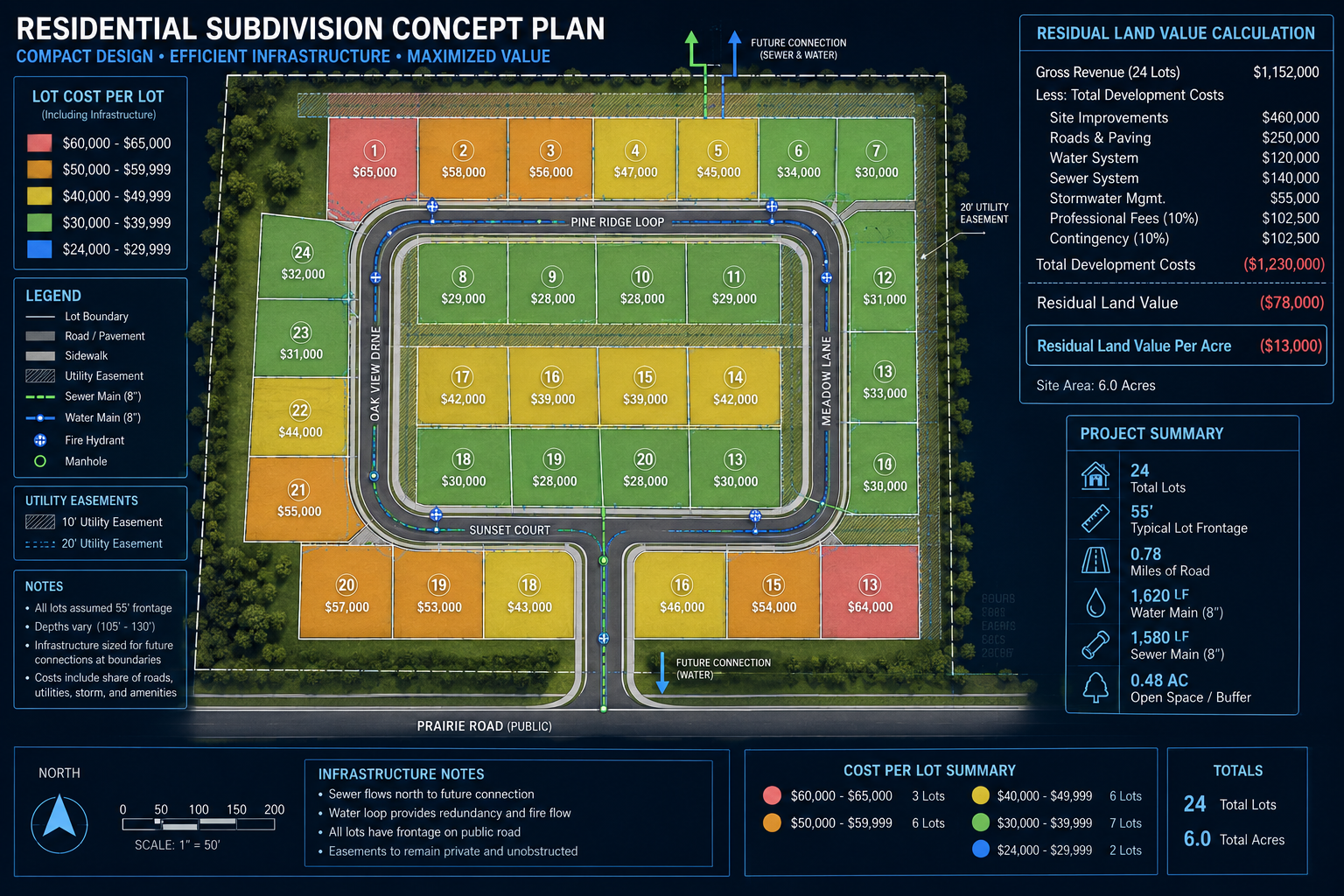
Residual Land Value: The Surveyor's Financial Framework
Builders and developers use residual land value modeling to determine what they can afford to pay for raw land. The process works backwards from the expected sale price of completed homes, subtracting all development costs and required profit margins to arrive at a maximum land acquisition price [5].
Surveyors who understand this model can align their lot yield recommendations with the financial realities of the development. Overstating achievable lot numbers is as damaging as understating them. Both errors destroy trust and erode project viability.
Residual land value formula (simplified):
Gross Development Value minus Construction Costs minus Infrastructure Costs minus Professional Fees minus Developer Profit equals Residual Land Value
A surveyor who can present lot yield analysis within this framework becomes an indispensable partner rather than a line-item cost.
Subdivision Appraisal and Absorption Studies
Subdivision appraisals evaluate an income stream, not just a static asset. Appraisers and lenders need to understand how long it will take to sell all lots and at what price points [10]. Surveyors who provide absorption study inputs, including lot size distribution, amenity proximity, and infrastructure completion timelines, strengthen the entire project's financing case.
Working with project management professionals who coordinate across surveying, engineering, and planning disciplines ensures that appraisal assumptions remain grounded in construction reality.
Value-Add Reporting: What Developers Actually Need
A standard survey report documents boundaries and measurements. A value-add report does far more. It identifies opportunities, quantifies risks, and provides the data developers need to make confident investment decisions.
Components of a high-value subdivision survey report:
- Lot yield analysis with sensitivity testing across zoning scenarios
- Infrastructure cost estimates by lot, broken down by road, sewer, water, and drainage
- Topographic risk assessment identifying grade challenges and soil issues
- Zoning compliance matrix confirming each lot meets all planning requirements
- Easement schedule documenting utility corridors, access rights, and restrictions
- Absorption rate projection based on comparable sales data
Developers reviewing a structural survey or RICS building survey alongside subdivision documentation expect consistent quality and depth of analysis across all professional inputs. Surveyors who match that standard position themselves as long-term development partners.
Monitoring During Construction
Subdivision surveying does not end when the plat is approved. Monitoring surveys during earthworks and infrastructure installation confirm that construction remains within design tolerances. Catching deviations early prevents expensive remediation and protects the surveyor's professional liability position.
Common Mistakes That Reduce Density and Value
Even experienced surveyors make design errors that cost developers money. Awareness of these patterns is the first step toward avoiding them.
Frequent errors in subdivision design:
- Over-engineering road widths beyond planning minimums, consuming land that could be allocated to lots
- Ignoring topography when placing lot boundaries, creating unbuildable areas within nominally compliant lots
- Failing to coordinate utility easements with building envelopes, restricting where structures can be placed
- Underestimating setback accumulation across multiple lots, which reduces effective yield below theoretical maximums
- Missing density bonus eligibility due to insufficient review of planning authority guidelines
Each of these errors reduces either the number of lots that can be sold or the price at which they can be marketed. In aggregate, they can turn a profitable project into a marginal one.
Conclusion: Actionable Steps Toward Subdivision Surveying Mastery
Subdivision surveying mastery: optimizing lot designs for maximum density and market value requires surveyors to operate at the boundary of technical precision and financial strategy. The housing shortage environment of 2026 rewards professionals who bring both capabilities to every project.
Actionable next steps for surveyors and developers:
- Commission a zoning feasibility review before any land acquisition to identify density potential and upzoning opportunities
- Conduct topographic and drainage surveys early to inform lot layout decisions before infrastructure costs are locked in
- Adopt residual land value modeling as a standard output in subdivision reports to align with developer financial frameworks
- Evaluate conservation subdivision design as a default option on sites with natural features worth preserving
- Build value-add reporting templates that go beyond boundary documentation to include yield analysis, cost estimates, and absorption projections
- Engage monitoring survey protocols throughout construction to protect design integrity and professional standing
Developers who partner with surveyors capable of delivering this level of strategic input gain a measurable competitive advantage. Surveyors who develop these skills position themselves at the highest-value tier of the profession.
References
[1] Subdivision Development Pro Forma – https://rivereditor.com/blogs/subdivision-development-pro-forma?utm_source=openai
[2] Subdivision Site Development Costs – https://backwell.com/blog/subdivision-site-development-costs/?utm_source=openai
[3] Optimizing Lot Layouts to Reduce Infrastructure Costs – https://www.jpcengineering.com/jpc-blog/vmr21m13r0xoz0sup35st0ewnanlhf?utm_source=openai
[4] Factors Affecting Land Value – https://www.highpointlandcompany.com/factors-affecting-land-value/?utm_source=openai
[5] How Home Builders Value Subdivision Land Pennsylvania – https://www.landadvisor.land/details/3017/how-home-builders-value-subdivision-land-pennsylvania?utm_source=openai
[6] Small Lot Subdivision Vs Traditional Subdivision – https://www.avicaconstruction.com/blog/small-lot-subdivision-vs-traditional-subdivision?utm_source=openai
[7] Conservation Subdivisions Economic Benefits – https://journals.sagepub.com/doi/pdf/10.1177/1078087405282183?utm_source=openai
[8] Finding The Value Of Your Lot A Simple Guide For Landowners – https://www.southern-acres.com/blog/finding-the-value-of-your-lot-a-simple-guide-for-landowners/?utm_source=openai
[9] Subdivision Investment Strategy Australia – https://stncivil.com/blog/subdivision-investment-strategy-australia?utm_source=openai
[10] Subdivision Analysis – https://www.elliottco.com/properties-serviced/land/subdivision-analysis/?utm_source=openai