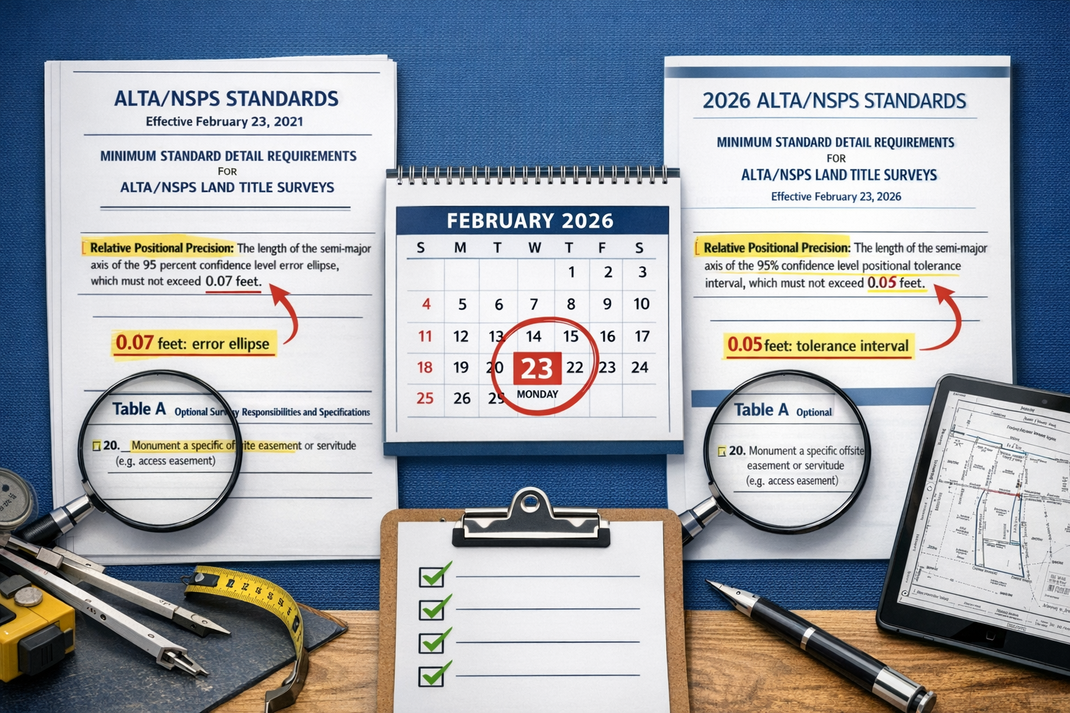
The clock is ticking. On February 23, 2026, a significant shift in land surveying standards takes effect across the United States, fundamentally changing how property boundaries, encroachments, and title evidence are documented. For property owners, developers, title companies, and surveyors, understanding these changes isn't just recommended—it's essential for ensuring smooth real estate transactions and avoiding costly delays.
Navigating the 2026 ALTA/NSPS Land Title Survey Updates: What Property Owners and Developers Need to Know has become a critical priority as the deadline approaches. The American Land Title Association (ALTA) and the National Society of Professional Surveyors (NSPS) have collaborated to refine their land title survey standards, introducing updates that emphasize clarity, transparency, accuracy, and communication rather than overhauling the entire surveying framework.[2]
These updates represent the most significant changes to land title surveying standards in recent years, with implications that extend far beyond the surveying community. Whether you're purchasing commercial property, developing residential land, or managing a real estate portfolio, the 2026 standards will directly impact your transactions, timelines, and documentation requirements.
Key Takeaways
- ✅ Effective Date: All new surveys must comply with 2026 ALTA/NSPS standards starting February 23, 2026, replacing the 2021 version
- 📋 Table A Item 20: A new standardized encroachment table eliminates inconsistent surveyor language and streamlines title insurance requirements
- 🎯 Enhanced Transparency: Surveyors must now document parol statements, possession evidence, and use standardized practices for greater clarity
- 📏 Refined Precision Standards: Updated Relative Positional Precision (RPP) definitions align with accepted measurement practices
- 🔄 Streamlined Processes: Changes eliminate the need for many survey revisions previously required by title insurers
Understanding the 2026 ALTA/NSPS Land Title Survey Standards
What Are ALTA/NSPS Land Title Surveys?
ALTA/NSPS Land Title Surveys represent the highest standard for boundary surveys in commercial real estate transactions. These comprehensive surveys provide detailed information about property boundaries, improvements, easements, rights-of-way, and potential encroachments that could affect property ownership or title insurance.[5]
Unlike basic boundary surveys, ALTA/NSPS surveys follow nationally recognized standards that ensure consistency across different states and jurisdictions. This standardization makes them invaluable for lenders, title companies, and investors who need reliable property information for making informed decisions.
The surveys typically include:
- Precise boundary measurements using advanced surveying equipment
- Location of improvements including buildings, fences, and utilities
- Easement identification and documentation
- Encroachment analysis in all directions
- Zoning compliance verification
- Access rights and restrictions
The Evolution from 2021 to 2026 Standards
The transition from 2021 to 2026 standards reflects the surveying industry's commitment to continuous improvement. Rather than introducing radical changes, the updates focus on refining existing practices and addressing common pain points experienced by surveyors, title companies, and property stakeholders.[2]
According to industry experts, the 2026 revisions emerged from extensive collaboration between ALTA and NSPS members, incorporating feedback from thousands of real-world survey transactions. The goal was to create standards that enhance communication, reduce ambiguity, and streamline the survey process without compromising accuracy or thoroughness.[1]
The evolution addresses several key areas:
- Standardization of encroachment reporting
- Clarification of measurement precision requirements
- Enhanced documentation of verbal statements
- Improved guidance on title evidence sourcing
- Refined responsibility language throughout the standards
For those seeking professional surveying services, working with experienced chartered surveyors who understand these evolving standards is crucial for ensuring compliance and avoiding transaction delays.
Key Changes in Navigating the 2026 ALTA/NSPS Land Title Survey Updates
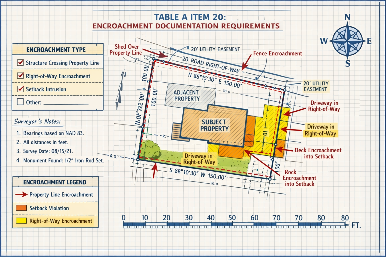
Table A Item 20: The Encroachment Revolution 📊
Perhaps the most significant change in the 2026 standards is the introduction of Table A Item 20, which creates a standardized format for documenting encroachments.[1][2] This new requirement fundamentally changes how surveyors communicate potential boundary violations and property conflicts.
What Table A Item 20 Requires:
The new item mandates that surveyors create a standardized table documenting:
- Encroachments crossing property boundaries in either direction (onto or from adjacent properties)
- Encroachments into rights-of-way or easements
- Encroachments into setback areas as defined by zoning regulations
- Observable evidence supporting each encroachment determination
This table must appear on the face of the survey plat or map when requested, making encroachment information immediately visible to all transaction parties.[2]
The Impact on Title Insurance:
Before 2026, title insurers frequently requested survey revisions to include specific encroachment statements, creating delays and additional costs. Each surveyor might use different language or formats, leading to inconsistency and confusion.[2]
The standardized table eliminates the need for these revision requests, streamlining the title insurance process and reducing transaction timelines. Title companies can now rely on consistent, predictable encroachment documentation across all ALTA/NSPS surveys.
Important Limitations:
Surveyors must understand that while they document and opine on physical encroachments, they cannot express legal opinions or opinions as to ownership in this table.[2] The surveyor's role is to identify observable conditions and measurements, not to interpret property rights or resolve legal disputes.
| Encroachment Type | Documentation Required | Surveyor's Role |
|---|---|---|
| Boundary Crossings | Measurements, location, description | Identify and measure |
| Rights-of-Way Violations | Dimensions, affected areas | Document observable evidence |
| Setback Intrusions | Distance from setback line | Compare to zoning requirements |
| Ownership Disputes | Physical observations only | NO legal opinion permitted |
Relative Positional Precision (RPP) Refinements 🎯
The 2026 standards include refined definitions for Relative Positional Precision (RPP), addressing confusion among stakeholders unfamiliar with advanced measurement techniques.[1]
What Changed:
The updated RPP definition now:
- Aligns more closely with accepted measurement practices in the surveying profession
- Provides clearer explanations for non-surveyors (attorneys, lenders, property owners)
- Establishes consistent standards for accuracy reporting
- Reduces ambiguity in precision requirements
Why It Matters:
RPP represents the level of accuracy between survey points on a property. Understanding these precision standards helps property owners and developers assess survey quality and determine whether the survey meets their specific project needs.
For complex projects requiring structural surveys or detailed boundary surveys, the refined RPP standards ensure that measurement accuracy meets industry best practices.
Parol Statements and Verbal Evidence 🗣️
A notable addition to the 2026 standards requires surveyors to document parol statements—verbal statements made by relevant landowners or occupants regarding title or boundary issues.[1][2]
What Constitutes a Parol Statement:
Parol statements include verbal information about:
- Historical boundary agreements
- Informal easement arrangements
- Possession claims or disputes
- Maintenance responsibilities
- Access rights or restrictions
Documentation Requirements:
When surveyors receive parol statements during fieldwork, they must:
- Note the statement in their field records
- Memorialize it on the survey with appropriate attribution
- Identify the source of the statement
- Avoid legal interpretation of the statement's validity
This requirement recognizes that verbal information often provides valuable context for understanding property conditions, even though such statements don't constitute legal evidence of title or rights.
Enhanced Title Evidence Guidance 📄
The 2026 standards provide additional guidance on sourcing title evidence when a recent title commitment is not available.[1] This addresses a common challenge faced by surveyors working on properties with complex ownership histories or in jurisdictions with limited title services.
New Guidance Includes:
- Acceptable alternative title evidence sources
- Documentation requirements when using alternative sources
- Communication protocols with clients about title evidence limitations
- Standards for verifying title information accuracy
This enhancement ensures that surveys can proceed efficiently even when traditional title commitments face delays, while maintaining the integrity and reliability of the survey product.
Possession and Occupation Evidence 🏘️
The updated standards now require surveyors to note evidence of possession or occupation along the property perimeter, regardless of proximity to boundary lines.[1]
What This Means:
Previously, surveyors might only document possession evidence near boundary lines. The 2026 standards expand this requirement to include:
- Fencing and barriers
- Landscaping and improvements
- Access roads and driveways
- Utility installations
- Signs of regular use or maintenance
- Structures and outbuildings
The Rationale:
This change recognizes that possession evidence throughout the property perimeter can indicate potential boundary disputes, adverse possession claims, or easement rights—even when such evidence doesn't immediately adjoin the boundary line.
For property owners concerned about boundary disputes or encroachment issues, this enhanced documentation provides valuable information for resolving conflicts and protecting property rights.
Implications for Property Owners and Developers in Navigating the 2026 ALTA/NSPS Land Title Survey Updates
Impact on Commercial Real Estate Transactions 🏢
The 2026 standards will significantly affect commercial real estate transactions, particularly in areas of due diligence, timeline management, and risk assessment.
Benefits for Commercial Buyers:
- Faster closing timelines due to reduced survey revision requests
- Standardized encroachment documentation enabling easier comparison across properties
- Enhanced transparency regarding boundary conditions and potential conflicts
- Improved communication between surveyors, title companies, and transaction parties
Considerations for Commercial Developers:
Developers planning projects should understand that the new standards may reveal encroachment issues earlier in the transaction process. While this increased transparency might initially seem challenging, it actually provides opportunities to:
- Address encroachment issues before closing
- Negotiate purchase price adjustments based on documented conditions
- Plan development projects with accurate boundary information
- Avoid post-closing surprises that could delay construction
For those requiring commercial building surveys or commercial property surveyor services, selecting professionals familiar with the 2026 standards ensures compliance and smooth transaction processes.
Residential Development Considerations 🏡
Residential developers face unique challenges and opportunities under the 2026 standards, particularly when developing subdivisions or multi-unit properties.
Key Considerations:
Subdivision Planning:
- Enhanced encroachment documentation helps identify lot line conflicts early
- Standardized reporting facilitates easier approval processes with municipalities
- Improved precision standards ensure accurate lot dimensions
Multi-Family Development:
- Clearer easement documentation supports utility planning
- Setback encroachment tables help optimize building placement
- Possession evidence requirements identify potential access disputes
Homebuilder Impact:
- Faster survey turnaround reduces pre-construction delays
- Standardized formats simplify review processes
- Enhanced communication reduces misunderstandings with title companies
Title Insurance and Closing Processes ⚖️
The 2026 standards create significant efficiencies in title insurance underwriting and closing processes.
For Title Companies:
The standardized encroachment table (Table A Item 20) provides:
- Consistent format across all surveys, reducing review time
- Clear encroachment documentation supporting underwriting decisions
- Reduced need for survey revisions, accelerating closing timelines
- Improved risk assessment capabilities
For Property Buyers:
Understanding the new standards helps buyers:
- Interpret survey documents more effectively
- Identify potential title issues earlier in the transaction
- Make informed decisions about title insurance coverage
- Negotiate resolutions to encroachment issues
Lender Requirements and Compliance 🏦
Commercial and residential lenders increasingly rely on ALTA/NSPS surveys as part of their due diligence processes. The 2026 updates affect lender requirements in several ways:
Enhanced Risk Assessment:
- Standardized encroachment documentation supports more accurate loan-to-value calculations
- Improved precision standards provide confidence in property boundaries
- Possession evidence helps identify potential adverse possession risks
Streamlined Approval Processes:
- Reduced survey revision requests accelerate loan approval timelines
- Consistent formatting simplifies review by underwriting teams
- Enhanced communication reduces delays from surveyor-lender misunderstandings
Practical Checklists for Navigating the 2026 ALTA/NSPS Land Title Survey Updates
Checklist for Surveyors ✅
As the February 23, 2026 deadline approaches, surveyors should ensure they're prepared to implement the new standards:
Pre-Implementation (Before February 23, 2026):
- Review complete 2026 ALTA/NSPS standards documentation
- Update survey templates to include Table A Item 20 format
- Revise fieldwork procedures to capture parol statements
- Train field crews on possession evidence documentation requirements
- Update software and CAD templates for 2026 compliance
- Review RPP calculation methods and documentation procedures
- Establish protocols for title evidence sourcing when commitments unavailable
- Create client communication materials explaining 2026 changes
During Fieldwork:
- Document all parol statements with source attribution
- Note possession/occupation evidence along entire property perimeter
- Collect measurements supporting encroachment determinations
- Photograph evidence of encroachments, possession, and occupation
- Verify practices comply with "generally recognized as acceptable" standards
- Document title evidence sources used
Survey Preparation and Delivery:
- Include Table A Item 20 on plat face when requested
- Verify encroachment table includes all required categories
- Confirm no legal opinions expressed in encroachment documentation
- Review RPP calculations and documentation
- Memorialize parol statements appropriately on survey
- Include possession evidence regardless of boundary proximity
Quality Control:
- Verify survey references 2026 standards (not 2021)
- Confirm all new requirements addressed
- Review for consistency with standardized formats
- Check communication clarity for non-surveyor audiences
Checklist for Property Owners and Developers 📋
Property stakeholders should prepare for the new standards to ensure smooth transactions:
Before Ordering a Survey:
- Verify survey will comply with 2026 standards (if after February 23, 2026)
- Confirm surveyor's familiarity with 2026 updates
- Discuss specific Table A items needed for your transaction
- Understand timeline implications of new requirements
- Review budget for potential additional documentation costs
- Communicate special concerns about encroachments or boundaries
During the Survey Process:
- Provide complete title information to surveyor
- Share any known boundary disputes or encroachment issues
- Make property accessible for fieldwork
- Be available to provide parol statements if relevant
- Respond promptly to surveyor questions or requests
- Coordinate with neighbors if boundary access needed
Upon Survey Receipt:
- Review Table A Item 20 encroachment documentation carefully
- Verify all requested Table A items included
- Check for parol statements or possession evidence notes
- Identify any encroachments requiring resolution
- Share survey with title company, lender, and attorney promptly
- Address any revealed issues before closing deadlines
For Development Projects:
- Incorporate survey findings into site planning
- Resolve encroachment issues before construction begins
- Use encroachment table to optimize building placement
- Verify setback compliance using standardized documentation
- Coordinate with project management teams on survey implications
Checklist for Title Companies and Attorneys ⚖️
Legal and title professionals should adapt their processes for the new standards:
Policy and Procedure Updates:
- Update survey review checklists for 2026 standards
- Revise title commitment language referencing surveys
- Train staff on Table A Item 20 interpretation
- Establish protocols for surveys dated before vs. after February 23, 2026
- Update survey revision request templates (if still needed)
- Create client education materials about 2026 changes
Transaction Management:
- Verify survey compliance with current standards
- Review Table A Item 20 encroachment documentation
- Assess title insurance implications of documented encroachments
- Communicate survey findings to clients clearly
- Coordinate encroachment resolutions with all parties
- Adjust closing timelines to account for new documentation
Risk Assessment:
- Evaluate encroachment table for underwriting implications
- Consider parol statements in title risk analysis
- Review possession evidence for adverse possession concerns
- Assess easement compliance using enhanced documentation
- Determine appropriate title insurance exceptions
Checklist for Lenders 🏦
Financial institutions should prepare their processes for the updated standards:
Underwriting Procedures:
- Update loan application requirements referencing survey standards
- Train underwriters on 2026 ALTA/NSPS changes
- Revise survey review checklists
- Establish protocols for evaluating Table A Item 20 encroachments
- Update loan-to-value calculation procedures
- Create escalation procedures for significant encroachment issues
Compliance and Documentation:
- Verify survey dates and applicable standards
- Confirm all required Table A items included
- Review encroachment documentation for loan risk
- Assess possession evidence implications
- Document survey compliance in loan files
Common Challenges and Solutions
Challenge 1: Transition Period Confusion
The Issue:
During the transition period around February 23, 2026, confusion may arise about which standards apply to surveys ordered before but completed after the effective date.
The Solution:
- Surveys must comply with the standards in effect when the survey is certified and delivered, not when ordered[1]
- Clearly communicate effective dates with surveyors when ordering surveys
- Build buffer time into transaction schedules for surveys ordered near the transition date
- Confirm standard compliance in writing before finalizing survey orders
Challenge 2: Interpreting Encroachment Tables
The Issue:
Property owners and developers unfamiliar with surveying terminology may struggle to interpret Table A Item 20 encroachment documentation.
The Solution:
- Request a meeting with the surveyor to review encroachment findings
- Ask for photographs or additional documentation of significant encroachments
- Consult with real estate attorneys about legal implications
- Work with expert surveyors who can explain findings clearly
- Don't hesitate to ask questions—surveyors expect and welcome clarification requests
Challenge 3: Addressing Revealed Encroachments
The Issue:
The enhanced encroachment documentation may reveal issues not previously identified, potentially complicating transactions.
The Solution:
- View early identification as an opportunity, not a problem
- Negotiate purchase price adjustments based on encroachment severity
- Obtain encroachment agreements from affected neighbors
- Consider title insurance coverage for minor encroachments
- Factor resolution costs into development budgets
- Delay closing if necessary to properly resolve significant issues
Challenge 4: Parol Statement Documentation
The Issue:
Property owners may be uncertain about what information to share with surveyors or concerned about how verbal statements will be documented.
The Solution:
- Understand that parol statements provide context, not legal determinations
- Share relevant historical information about boundaries, easements, or access
- Be truthful and complete in verbal communications with surveyors
- Review how parol statements are memorialized on the survey
- Consult with attorneys if concerned about legal implications of statements
Challenge 5: Cost and Timeline Implications
The Issue:
Enhanced documentation requirements may affect survey costs and completion timelines.
The Solution:
- Request detailed quotes that reflect 2026 standard requirements
- Build appropriate timelines into transaction schedules
- Understand that comprehensive documentation may prevent costly post-closing issues
- Consider the long-term value of enhanced survey quality
- Budget appropriately for professional survey services
Best Practices for Smooth Implementation
For All Stakeholders 🤝
Communication is Key:
The 2026 standards emphasize transparency and clear communication. All transaction parties should:
- Establish clear communication channels early in the process
- Ask questions when survey documentation is unclear
- Share relevant information proactively
- Respond promptly to requests for information or clarification
- Document important communications in writing
Education and Training:
Invest time in understanding the new standards:
- Review ALTA/NSPS published guidance materials
- Attend industry webinars and training sessions
- Consult with experienced professionals familiar with the updates
- Share knowledge within your organization
- Stay informed about industry best practices
Proactive Planning:
Anticipate how the new standards affect your processes:
- Update internal procedures and checklists
- Revise templates and forms
- Train staff on new requirements
- Build appropriate timelines into project schedules
- Budget for enhanced documentation requirements
Working with Professional Surveyors
Selecting the right surveyor is crucial for navigating the 2026 updates successfully. Consider these factors:
Qualifications and Experience:
- Verify licensure and professional credentials
- Confirm familiarity with 2026 ALTA/NSPS standards
- Ask about experience with similar property types
- Request references from recent clients
- Check professional association memberships
Communication and Service:
- Assess responsiveness during initial consultations
- Evaluate clarity of explanations and documentation
- Confirm availability to answer questions throughout the process
- Discuss communication preferences and protocols
- Establish expectations for review meetings if needed
Technology and Capabilities:
- Inquire about surveying equipment and technology
- Verify capability to produce required documentation formats
- Confirm ability to meet project-specific requirements
- Discuss data delivery formats and accessibility
For comprehensive surveying services that incorporate the latest standards, consider working with established firms offering various types of surveys to meet diverse property needs.
Looking Ahead: The Future of Land Title Surveys

Industry Trends and Innovations 🚀
The 2026 standards represent an evolution in land title surveying, but the industry continues to advance:
Technology Integration:
- Increased use of drone technology for site documentation
- Advanced GPS and positioning systems improving accuracy
- Digital delivery platforms enhancing accessibility
- 3D modeling capabilities for complex properties
- Automated quality control systems
Sustainability Considerations:
- Environmental feature documentation
- Green infrastructure mapping
- Climate resilience assessments
- Sustainable development planning support
Enhanced Data Accessibility:
- Cloud-based survey data storage
- Mobile-friendly survey document formats
- Integration with GIS systems
- Improved data sharing among transaction parties
Preparing for Future Updates
While the 2026 standards will govern surveys for the foreseeable future, stakeholders should remain prepared for ongoing evolution:
Stay Informed:
- Monitor ALTA and NSPS communications
- Participate in industry associations
- Attend continuing education opportunities
- Subscribe to professional publications
- Network with industry peers
Maintain Flexibility:
- Build adaptable processes and procedures
- Invest in scalable technology solutions
- Foster relationships with knowledgeable professionals
- Embrace continuous improvement mindset
Advocate for Excellence:
- Support industry standards development
- Provide feedback on practical implementation challenges
- Share best practices with peers
- Promote professional surveying standards
Conclusion
Navigating the 2026 ALTA/NSPS Land Title Survey Updates: What Property Owners and Developers Need to Know requires understanding, preparation, and collaboration among all transaction stakeholders. The February 23, 2026 effective date marks a significant milestone in land surveying standards, introducing enhancements that prioritize clarity, transparency, and communication.
The introduction of Table A Item 20 standardizes encroachment documentation, eliminating inconsistencies and streamlining title insurance processes. Refined Relative Positional Precision definitions enhance measurement clarity for all stakeholders. Requirements for documenting parol statements and possession evidence provide valuable context for understanding property conditions. Enhanced guidance on title evidence sourcing ensures surveys can proceed efficiently even when traditional documentation faces challenges.
These updates don't represent a complete overhaul of surveying practices but rather a thoughtful refinement that addresses real-world challenges experienced by surveyors, title companies, lenders, attorneys, property owners, and developers. By embracing these standards, the industry moves toward greater consistency, reduced transaction delays, and improved risk management.
Actionable Next Steps
For Property Owners and Developers:
- Review any pending transactions to determine which standards apply
- Select qualified surveyors familiar with 2026 requirements
- Update project timelines to accommodate enhanced documentation
- Budget appropriately for comprehensive survey services
- Communicate proactively with transaction parties about survey requirements
For Surveyors:
- Complete training on 2026 standard requirements before the effective date
- Update templates and procedures to ensure compliance
- Train field crews on new documentation requirements
- Communicate changes to clients and transaction partners
- Implement quality control measures verifying 2026 compliance
For Title Companies and Lenders:
- Revise internal procedures to reflect new standards
- Train staff on interpreting 2026 survey documentation
- Update survey requirements in transaction documents
- Establish clear communication protocols with surveyors
- Educate clients about the benefits of enhanced standards
For All Stakeholders:
- Stay informed about industry guidance and best practices
- Ask questions when survey documentation is unclear
- Collaborate proactively with transaction partners
- View enhanced standards as opportunities for improved outcomes
- Invest in professional expertise to navigate complex situations
The 2026 ALTA/NSPS Land Title Survey Updates represent a positive evolution in professional surveying standards. By understanding these changes and implementing the checklists and best practices outlined in this guide, property owners, developers, and all transaction stakeholders can navigate the transition smoothly and leverage the benefits of enhanced clarity, consistency, and communication in land title surveys.
Whether you're planning a commercial development, purchasing residential property, or managing real estate transactions, the time to prepare is now. The February 23, 2026 deadline is approaching, and proactive preparation ensures your projects proceed without delay while benefiting from the improved standards that will govern land title surveys for years to come.
References
[1] Key Updates To The 2026 Alta Nsps Land Title Survey Standards – https://ltaal.org/key-updates-to-the-2026-alta-nsps-land-title-survey-standards/
[2] Nsps Land Title – https://www.parkerpoe.com/news/2026/02/key-takeaways-from-the-2026-alta/nsps-land-title
[3] 20260126 Alta Insights Understanding The 2026 Altansps Land Title Survey Standards – https://www.alta.org/news-and-publications/news/20260126-ALTA-Insights-Understanding-the-2026-ALTANSPS-Land-Title-Survey-Standards
[4] 2026 Alta Nsps Land Title Survey Standards – https://www.partneresi.com/resources/references/standards-regulations/2026-alta-nsps-land-title-survey-standards/
[5] Alta Nsps Survey – https://cretelligent.com/alta-nsps-survey/
[6] Watch – https://www.youtube.com/watch?v=_xb2pV0_29E