The property surveying profession stands at a critical crossroads in 2026. As artificial intelligence algorithms analyze boundary data and drones capture aerial measurements with unprecedented speed, surveyors face a new generation of legal challenges that their predecessors never imagined. Recent litigation reveals a troubling pattern: AI mispredictions leading to boundary disputes, incomplete drone captures missing critical property features, and regulatory shifts creating compliance gaps that expose professionals to significant liability. Understanding Legal Liabilities in Modern Property Surveying: Mitigating Risks from AI Errors, Drone Data Disputes, and Regulatory Shifts has become essential for every surveying professional navigating this transformed landscape.
The stakes have never been higher. A single algorithmic error can misplace a property line by several feet, triggering costly construction delays, neighbor disputes, and professional negligence claims. Meanwhile, the 2026 ALTA/NSPS standards update has fundamentally changed documentation requirements, creating new obligations that many surveyors are still struggling to implement. This comprehensive guide explores the evolving legal landscape, examines real-world case studies, and provides actionable strategies for protecting your practice in an era where technology and regulation are reshaping professional liability.
Key Takeaways
- AI-assisted surveying tools introduce new liability risks when algorithms produce inaccurate boundary predictions or miss critical property features, requiring enhanced human verification protocols
- Drone technology disputes are increasing as incomplete aerial captures and data interpretation errors lead to measurement discrepancies and professional negligence claims
- 2026 ALTA/NSPS standards mandate expanded documentation for easements, utilities, and boundary discrepancies, creating new compliance obligations and legal defensibility requirements[2][4]
- Professional insurance policies must now specifically address technology-related errors, with coverage gaps emerging for AI-generated mistakes and drone data failures
- Risk mitigation strategies combining technology validation, enhanced documentation, and updated professional standards offer the strongest protection against emerging legal liabilities
Understanding the New Landscape of Legal Liabilities in Modern Property Surveying
The Technology Revolution in Property Surveying
The surveying profession has undergone a dramatic transformation over the past five years. Traditional methods involving theodolites, measuring chains, and manual calculations have given way to sophisticated technologies that promise greater accuracy and efficiency. Artificial intelligence platforms now analyze historical property records, satellite imagery, and GIS data to generate preliminary boundary predictions. Drone-based photogrammetry captures detailed aerial measurements in hours rather than days. LiDAR scanning produces three-dimensional property models with millimeter precision.
This technological revolution has delivered genuine benefits. Drone surveys can access difficult terrain, reduce fieldwork time, and provide comprehensive visual documentation. AI algorithms can process vast datasets to identify patterns and anomalies that human reviewers might miss. However, these same technologies have introduced unprecedented liability exposures that many professionals underestimate.
Emerging Legal Challenges in 2026
The legal framework governing property surveying was developed for an analog world. Courts, insurance companies, and regulatory bodies are now scrambling to address questions that didn't exist a decade ago:
- Who bears responsibility when an AI algorithm misinterprets historical survey data and produces an incorrect boundary determination?
- What standard of care applies when drone captures miss critical property features due to weather conditions, vegetation, or equipment limitations?
- How should courts evaluate the reliability of AI-generated predictions versus traditional surveying methods?
- What documentation requirements must surveyors meet when combining multiple technology platforms?
These questions aren't theoretical. Recent case law from 2025-2026 reveals a troubling pattern of litigation where surveyors face negligence claims specifically related to technology failures. Understanding Legal Liabilities in Modern Property Surveying: Mitigating Risks from AI Errors, Drone Data Disputes, and Regulatory Shifts requires examining these emerging legal precedents and their implications for professional practice.
The Professional Standard of Care Evolution
Courts have traditionally evaluated surveyor liability using the "reasonable professional" standard—would a competent surveyor using accepted methods have reached the same conclusion? This standard is evolving rapidly as technology becomes mainstream. In 2026, courts increasingly expect surveyors to:
✅ Verify AI-generated predictions through independent field measurements rather than accepting algorithmic outputs at face value
✅ Disclose technology limitations to clients, particularly when weather, vegetation, or site conditions may compromise drone data quality
✅ Maintain human oversight of automated processes, with documented review protocols
✅ Update professional knowledge continuously as technology and standards evolve
The professional surveying community is adapting to these expectations, but the transition creates liability gaps. Surveyors who adopted technology early without adequate quality control protocols now face heightened scrutiny. Those who resisted technological adoption may struggle to meet evolving client expectations and competitive pressures.
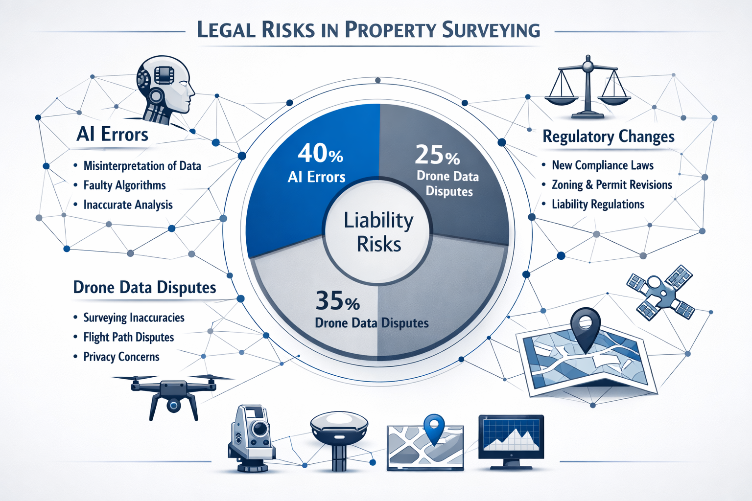
AI Errors in Property Surveying: Legal Risks and Liability Mitigation
How AI Systems Generate Surveying Errors
Artificial intelligence has become deeply embedded in modern surveying workflows. Machine learning algorithms analyze historical property records, aerial imagery, and topographic data to generate boundary predictions. Computer vision systems process drone photographs to identify property features and measure distances. Predictive analytics estimate property values and identify potential encroachment risks.
These systems deliver impressive results under ideal conditions, but they fail in predictable ways that create legal liability:
🔴 Training data bias: AI algorithms trained primarily on suburban residential properties may produce unreliable results for rural, commercial, or irregularly-shaped parcels
🔴 Historical record misinterpretation: Machine learning systems may incorrectly parse handwritten survey notes, ambiguous legal descriptions, or conflicting historical documents
🔴 Feature recognition failures: Computer vision algorithms may misidentify property boundaries, confusing fence lines with legal boundaries or missing partially obscured markers
🔴 Confidence score misunderstanding: Surveyors may not recognize that a 95% AI confidence score still represents a 1-in-20 chance of significant error
When these failures occur, the legal consequences can be severe. Property owners who discover boundary errors after construction may sue for negligence, seeking damages for demolition costs, reconstruction expenses, and diminished property value. Title companies may pursue claims when AI-assisted surveys miss easements or encroachments that later complicate transactions.
Recent Case Law on AI-Related Survey Errors
While comprehensive case law is still developing, several 2025-2026 decisions illustrate emerging judicial approaches to AI-related surveying errors:
Commercial Property Boundary Dispute (California, 2025): A surveying firm used AI software to analyze historical records and generate boundary predictions for a commercial development. The algorithm misinterpreted a 1940s metes-and-bounds description, placing the western boundary 8.5 feet from its actual location. The error wasn't discovered until the developer had completed foundation work. The court found the surveyor negligent for failing to verify the AI-generated boundary through independent field measurements, awarding $340,000 in damages for reconstruction costs.
Residential Easement Omission (Texas, 2026): An AI-assisted survey failed to identify a utility easement that appeared in historical records using non-standard terminology. The computer vision system didn't recognize the easement markers during drone image analysis. When the property owner attempted to build a fence within the easement area, the utility company obtained an injunction and the owner sued the surveying firm. The court emphasized that professional surveyors cannot delegate their duty of reasonable care to automated systems without adequate oversight.
These cases establish important precedents: AI tools are aids, not substitutes for professional judgment. Surveyors who rely on algorithmic outputs without independent verification face significant liability exposure.
Best Practices for Mitigating AI-Related Liability
Protecting your practice from AI-related claims requires implementing robust quality control protocols:
1. Establish Clear AI Verification Procedures
Create documented workflows that require human verification of all AI-generated predictions. This should include:
- Field verification of at least 20% of AI-identified property corners
- Manual review of historical documents that AI systems analyzed
- Independent calculation verification for critical measurements
- Documented explanation of any discrepancies between AI predictions and field measurements
2. Maintain Detailed Technology Documentation
Your survey reports should clearly disclose:
- Which AI tools were used and for what purposes
- The confidence scores or accuracy ratings the system provided
- Any limitations or assumptions in the AI analysis
- How human surveyors verified or modified AI-generated results
This documentation serves two purposes: it manages client expectations and provides legal protection if disputes arise. When conducting comprehensive property surveys, transparency about methodology strengthens professional credibility.
3. Update Professional Liability Insurance
Many traditional surveying insurance policies don't adequately cover AI-related errors. Review your coverage to ensure it specifically addresses:
- Errors in AI-generated boundary predictions
- Failures in computer vision property feature identification
- Data processing errors in automated measurement systems
- Technology vendor liability limitations
4. Implement Continuous Training Programs
AI technology evolves rapidly. Establish quarterly training sessions where your team:
- Reviews recent AI system updates and their implications
- Analyzes case studies of AI-related surveying errors
- Practices verification protocols for different property types
- Updates internal quality control standards based on emerging best practices
The Human-AI Collaboration Framework
The most successful surveying practices in 2026 have adopted a collaborative framework that leverages AI strengths while maintaining human oversight. This approach recognizes that:
- AI excels at pattern recognition across large datasets but struggles with unusual or ambiguous situations
- Human surveyors provide contextual judgment that algorithms cannot replicate
- Combined approaches deliver better results than either method alone
When properly implemented, this framework transforms AI from a liability risk into a competitive advantage. The key is maintaining clear boundaries: AI handles data processing and preliminary analysis, while human professionals make final determinations and assume professional responsibility.
Drone Data Disputes and Documentation Requirements
The Rise of Drone-Based Property Surveying
Drone technology has revolutionized property surveying by providing rapid, cost-effective aerial data collection. Modern surveying drones equipped with high-resolution cameras, GPS systems, and LiDAR sensors can capture comprehensive property data in a fraction of the time required for traditional ground-based methods. The benefits are substantial:
- Reduced fieldwork time from days to hours for large properties
- Access to difficult terrain including steep slopes, wetlands, and densely vegetated areas
- Comprehensive visual documentation that clients can easily understand
- Three-dimensional modeling capabilities for complex topographic analysis
These advantages have made drone surveys increasingly popular for both residential and commercial applications. However, the technology introduces specific legal vulnerabilities that surveyors must address.
Common Drone Data Disputes
Legal disputes involving drone-based surveys typically arise from several recurring issues:
Incomplete Coverage: Weather conditions, battery limitations, or flight planning errors may result in gaps in aerial coverage. Critical property features in shadowed areas, beneath tree canopy, or at property edges may not be adequately captured. When these omissions lead to boundary disputes or missed encroachments, property owners may claim professional negligence.
Measurement Accuracy Discrepancies: Drone-based photogrammetry relies on complex calculations to convert two-dimensional images into three-dimensional measurements. Factors including camera calibration, GPS accuracy, ground control point placement, and processing software settings all affect final measurement precision. When drone-derived measurements differ from traditional ground surveys, disputes arise over which method provides the authoritative result.
Temporal Data Issues: Drone surveys capture property conditions at a specific moment in time. Vegetation, weather, and seasonal variations may obscure or alter property features. A winter drone survey might miss fence lines obscured by summer vegetation, or a dry-season survey might not identify drainage easements visible only during wet conditions.
Regulatory Compliance Gaps: Drone operations are subject to aviation regulations, privacy laws, and airspace restrictions. Surveyors who operate drones without proper certification, fail to obtain required permits, or violate privacy expectations may face legal claims independent of survey accuracy issues.
The 2026 ALTA/NSPS Standards Impact on Drone Surveys
The 2026 update to the ALTA/NSPS Land Title Survey standards has significant implications for drone-based surveying. These nationally recognized standards govern commercial property surveys and increasingly influence residential surveying practices as well.
Enhanced Documentation Requirements: The 2026 standards require surveyors to disclose gaps or overlaps between parcels and explain all significant differences between recorded dimensions and actual field measurements[2]. This requirement directly addresses drone data limitations—surveyors must explicitly document:
- Areas where drone coverage was incomplete or compromised
- Discrepancies between drone-derived measurements and ground-based verification
- Assumptions or limitations in photogrammetric processing
- Weather or environmental conditions that may have affected data quality
Improved Precision Standards: The updated standards create stronger legal defensibility by ensuring boundary measurements are accurate and defensible if contested later[2]. For drone surveys, this means:
- Establishing and documenting ground control points with known coordinates
- Verifying critical measurements through independent methods
- Maintaining detailed processing logs showing how raw drone data was converted to final measurements
- Meeting specific accuracy tolerances for different survey elements
Expanded Easement and Utility Documentation: The 2026 update significantly strengthens how surveys handle easements, utilities, access points, and encroachments, requiring more detailed notes and observations[2]. This is particularly relevant for drone surveys because:
- Aerial imagery may not reveal underground utilities or buried easement markers
- Overhead utility lines must be identified if poles are within 10 feet of property boundaries[4]
- Surveyors must document which features were identified through drone data versus ground investigation
These enhanced standards provide clearer guidance for drone-based surveying while simultaneously creating new compliance obligations. Surveyors who fail to meet these documentation requirements face increased liability exposure.
Risk Mitigation Strategies for Drone Surveys
Protecting your practice from drone-related disputes requires implementing comprehensive protocols:
Pre-Flight Planning and Documentation
Before conducting any drone survey:
- Document weather conditions, visibility, and lighting
- Identify potential coverage limitations (vegetation, structures, shadows)
- Establish ground control points with surveyed coordinates
- Create a detailed flight plan with overlap specifications
- Verify all required permits and airspace authorizations
Quality Control During Data Collection
During the survey:
- Monitor real-time coverage to identify gaps
- Capture redundant imagery from multiple angles
- Document any anomalies or unusual conditions
- Conduct preliminary processing to verify data completeness before leaving the site
Post-Processing Verification
After data collection:
- Verify critical measurements through ground-based methods
- Compare drone-derived data against available historical surveys
- Document processing parameters and software versions
- Identify and explain any measurement discrepancies
- Generate comprehensive visual documentation showing coverage areas
Client Communication and Expectation Management
Clear communication prevents many disputes:
- Explain drone technology capabilities and limitations in engagement letters
- Disclose specific conditions that may affect data quality
- Provide realistic accuracy expectations for different property features
- Recommend supplementary ground-based verification for critical applications
When conducting homebuyer surveys or RICS building surveys, integrating drone data with traditional inspection methods provides comprehensive coverage while managing liability risks.
Regulatory Shifts and Compliance Obligations in 2026

The 2026 ALTA/NSPS Standards: Comprehensive Overview
The American Land Title Association (ALTA) and National Society of Professional Surveyors (NSPS) jointly publish minimum standard detail requirements for land title surveys. The 2026 update represents the most significant revision in over a decade, directly addressing technological changes and emerging liability concerns.
Key Changes Affecting Legal Liabilities in Modern Property Surveying:
Enhanced Boundary Documentation: Surveyors must now disclose gaps or overlaps between parcels and explain all significant differences between recorded dimensions and actual field measurements, reducing ambiguity in survey documents[2]. This requirement directly addresses a common source of litigation—ambiguous survey reports that leave room for conflicting interpretations.
Utility Identification Specificity: Evidence requirements now specify that utility poles on or within 10 feet of property boundaries and other utility features within five feet must be identified[4]. This expanded scope increases surveyor obligations and potential liability for missed utility features.
Easement and Access Documentation: The 2026 update significantly strengthens how surveys handle easements, utilities, access points, and encroachments, requiring more detailed notes and observations[2]. Surveyors must now:
- Document all visible evidence of easement use
- Identify access points and their relationship to recorded easements
- Note any apparent encroachments with precise measurements
- Explain discrepancies between recorded easement descriptions and physical evidence
Improved Precision Requirements: New precision standards create stronger legal defensibility by ensuring boundary measurements are accurate and defensible if contested later[2]. These standards establish clear benchmarks for measurement accuracy across different survey elements.
Impact on Surveying Practice and Costs
The enhanced documentation requirements raise practical questions about implementation costs and workflow impacts. Industry analysis suggests that while surveyors may spend more time on documentation, fieldwork and measurement standards haven't fundamentally changed; only complex properties with extensive easements may require additional effort[2].
Title Company Benefits: Clearer survey standards give title companies the ability to identify issues earlier, reducing last-minute complications at closing[2]. This creates indirect pressure on surveyors to meet enhanced standards, as title companies increasingly reject surveys that don't fully comply with 2026 requirements.
Lender Communication Improvements: Standardized formatting and consistent explanations help lenders better understand surveyor findings and property risk assessments[2]. This standardization reduces ambiguity but also creates less flexibility for surveyors to qualify or contextualize findings.
No Significant Cost Increase Projected: Industry experts anticipate that most routine surveys won't see substantial cost increases, as the enhanced requirements primarily affect documentation rather than field methodology[2]. However, surveyors should review their fee structures to ensure adequate compensation for expanded documentation obligations.
State-Level Regulatory Developments
Beyond the ALTA/NSPS standards, individual states continue developing surveying regulations that affect legal liability:
California Professional Land Surveyors Act: California maintains comprehensive regulations governing surveying practice, including specific requirements for survey monuments, record keeping, and professional responsibility[3]. These state-level requirements often exceed national standards and create additional compliance obligations.
Licensing and Continuing Education: Most states now require continuing education specifically addressing technology integration, with topics including:
- Drone operation and data processing
- AI tool validation and verification
- Updated boundary law and case precedents
- Professional liability risk management
Technology-Specific Regulations: Several states have introduced regulations specifically governing drone-based surveys, AI-assisted boundary determinations, and digital data management. Surveyors practicing across multiple states must navigate varying requirements that can create compliance challenges.
Compliance Strategies for the 2026 Regulatory Environment
Successfully navigating Legal Liabilities in Modern Property Surveying: Mitigating Risks from AI Errors, Drone Data Disputes, and Regulatory Shifts requires proactive compliance strategies:
1. Implement Standardized Documentation Templates
Create comprehensive templates that ensure all 2026 ALTA/NSPS requirements are addressed:
- Pre-populated checklists for easement documentation
- Standard language for explaining measurement discrepancies
- Structured formats for utility feature identification
- Consistent precision reporting across all survey types
2. Establish Regular Compliance Audits
Conduct quarterly reviews of completed surveys to verify:
- All required documentation elements are present
- Explanations meet clarity and completeness standards
- Technology use is properly disclosed and verified
- State-specific requirements are satisfied
3. Maintain Current Regulatory Knowledge
Subscribe to professional association updates, attend industry conferences, and participate in continuing education programs that address:
- Emerging case law affecting surveying liability
- Regulatory changes at state and national levels
- Industry best practices for technology integration
- Insurance coverage developments
4. Update Client Engagement Agreements
Revise engagement letters and contracts to:
- Clearly specify which standards will govern the survey
- Disclose technology use and verification protocols
- Establish realistic expectations for accuracy and completeness
- Define scope limitations and exclusions
When providing specialist defect surveys or property certification services, ensuring compliance with current regulatory standards protects both professional reputation and legal standing.
The Future Regulatory Trajectory
Regulatory trends suggest continued evolution in several areas:
Increased Technology Governance: Expect more specific regulations addressing AI algorithm validation, drone data quality standards, and digital documentation requirements. Regulatory bodies are working to establish clear benchmarks for technology-assisted surveying that balance innovation with professional accountability.
Enhanced Professional Liability Standards: Courts and regulatory agencies are developing more sophisticated approaches to evaluating technology-related errors. The "reasonable professional" standard is evolving to incorporate expectations for technology verification and quality control.
Interstate Practice Harmonization: Professional organizations are pushing for greater consistency across state boundaries, potentially streamlining compliance for surveyors practicing in multiple jurisdictions. However, this harmonization process will take years to achieve meaningful results.
Professional Liability Insurance in the Technology Era
Coverage Gaps in Traditional Policies
Many surveyors discover too late that their professional liability insurance doesn't adequately address technology-related claims. Traditional policies were designed for an era when surveying errors primarily involved field measurement mistakes or calculation errors. Modern claims involving AI mispredictions or drone data failures may not fit neatly within traditional coverage frameworks.
Common Coverage Limitations:
🔍 Technology Vendor Exclusions: Some policies exclude claims arising from third-party software or equipment failures, potentially leaving surveyors unprotected when AI algorithms or drone systems malfunction.
🔍 Data Processing Errors: Traditional policies may not clearly cover errors in photogrammetric processing, point cloud analysis, or algorithmic boundary determinations.
🔍 Cyber Liability Gaps: Digital data breaches, ransomware attacks affecting survey files, or unauthorized access to client property data may require separate cyber liability coverage.
🔍 Regulatory Violation Penalties: Fines or penalties for failing to meet updated regulatory standards may not be covered under standard professional liability policies.
Essential Insurance Updates for 2026
Surveyors should work with insurance professionals who understand modern surveying technology to ensure adequate coverage:
Expanded Technology Error Coverage: Policies should explicitly cover claims arising from:
- AI-generated boundary prediction errors
- Drone data collection or processing failures
- Computer vision system misidentification of property features
- Software calculation or analysis errors
Regulatory Compliance Coverage: Ensure your policy addresses:
- Defense costs for regulatory investigations
- Penalties or fines for inadvertent standard violations
- Costs associated with correcting non-compliant surveys
Cyber and Data Protection: Consider supplemental coverage for:
- Data breach notification and remediation costs
- Business interruption from ransomware or system failures
- Third-party claims arising from data security failures
Adequate Limits for Technology Claims: Technology-related errors can generate substantial damages. Review your coverage limits to ensure they're adequate for:
- Complex commercial property disputes
- Multi-party claims involving developers, lenders, and title companies
- Reconstruction costs when boundary errors affect completed construction
Risk Management Beyond Insurance
While adequate insurance is essential, the best protection comes from preventing claims before they arise:
Quality Control Systems: Implement documented quality control protocols that demonstrate reasonable professional care:
- Multi-level review processes for complex surveys
- Peer review for high-value or technically challenging projects
- Standardized checklists ensuring all requirements are addressed
- Technology verification procedures with documented results
Client Education and Communication: Many disputes arise from mismatched expectations rather than actual professional errors:
- Provide clear explanations of survey scope and limitations
- Discuss technology capabilities and potential uncertainties
- Document all client communications regarding survey methodology
- Obtain written acknowledgment of scope limitations
Continuing Professional Development: Maintain current knowledge through:
- Regular training on emerging technologies
- Participation in professional association activities
- Review of recent case law and regulatory developments
- Consultation with legal professionals on complex matters
Documentation Excellence: Comprehensive documentation serves both quality control and legal protection purposes:
- Maintain detailed field notes and observation records
- Document all verification procedures and results
- Preserve raw data files and processing parameters
- Create clear, unambiguous survey reports
Practical Implementation: Building a Bulletproof Surveying Practice
Developing Comprehensive Quality Assurance Protocols
Creating a resilient surveying practice in 2026 requires systematic quality assurance that addresses traditional surveying fundamentals while incorporating technology-specific safeguards:
Technology Validation Framework:
Stage 1: Pre-Survey Planning
- Evaluate which technologies are appropriate for specific property characteristics
- Identify potential limitations based on site conditions
- Establish verification benchmarks and acceptance criteria
- Document technology selection rationale
Stage 2: Data Collection
- Implement redundant measurement systems for critical boundaries
- Establish ground control points with independent verification
- Document environmental conditions affecting data quality
- Conduct real-time quality checks during fieldwork
Stage 3: Processing and Analysis
- Verify software settings and processing parameters
- Compare technology-generated results against independent measurements
- Document any discrepancies and resolution methodology
- Conduct peer review for complex or high-value projects
Stage 4: Reporting and Delivery
- Clearly disclose technology use and verification procedures
- Explain limitations and assumptions in accessible language
- Provide supporting documentation for critical determinations
- Include appropriate qualifications and disclaimers
Staff Training and Professional Development
Your team's competence directly affects your liability exposure. Implement structured training programs addressing:
Technical Competency:
- Drone operation certification and recurrent training
- AI tool operation and output interpretation
- Photogrammetric processing and quality control
- Advanced surveying software proficiency
Professional Judgment:
- Case study analysis of technology-related errors
- Decision-making frameworks for ambiguous situations
- Client communication and expectation management
- Ethical considerations in technology-assisted surveying
Regulatory Compliance:
- Current ALTA/NSPS standards and state requirements
- Documentation best practices and template use
- Quality control procedures and verification protocols
- Professional liability risk identification
Client Relationship Management
Strong client relationships prevent many potential disputes:
Engagement Phase:
- Provide detailed proposals explaining methodology and deliverables
- Discuss technology use, capabilities, and limitations
- Establish clear scope boundaries and exclusions
- Document client requirements and expectations
During Survey Execution:
- Communicate promptly about any unexpected findings or complications
- Provide preliminary results for client review when appropriate
- Address questions or concerns before finalizing deliverables
- Maintain professional boundaries while being responsive
Delivery and Follow-Up:
- Schedule review meetings to explain findings and answer questions
- Provide clear documentation that clients can understand
- Offer reasonable follow-up support for clarification
- Request feedback to improve future service delivery
Technology Vendor Management
Your technology vendors can be valuable partners or liability sources:
Vendor Selection Criteria:
- Established track record in surveying applications
- Transparent documentation of accuracy specifications
- Responsive technical support and training resources
- Clear contractual terms regarding liability and warranties
Ongoing Vendor Relationships:
- Maintain current software versions and security updates
- Participate in vendor training and user group activities
- Document known limitations or issues with vendor systems
- Establish backup systems for critical technology dependencies
Contractual Protections:
- Review vendor contracts for liability limitations
- Ensure vendor insurance covers potential equipment failures
- Establish clear service level agreements for support
- Document vendor responsibilities in your quality control procedures
Case Studies: Learning from Real-World Scenarios
Case Study 1: AI Boundary Prediction Error
Situation: A surveying firm used AI software to analyze historical records for a 5-acre commercial property. The algorithm processed 150 years of property records and generated boundary predictions with a reported 97% confidence level. The surveyor verified two of the four property corners through field measurements, finding them consistent with AI predictions. Based on this partial verification, the surveyor accepted the AI-generated boundaries for the remaining corners.
Problem: The AI algorithm had misinterpreted a 1920s legal description that used a now-obsolete measurement system. The southern boundary was actually 12 feet north of the AI-predicted location. The error wasn't discovered until the property owner began construction and the neighboring property owner objected.
Legal Outcome: The property owner sued for negligence, seeking $280,000 in damages for construction delays, redesign costs, and lost development value. The court found the surveyor negligent for failing to verify all property corners independently, noting that a 97% confidence score still represented a meaningful error probability that required verification.
Lessons Learned:
- AI confidence scores don't eliminate the need for comprehensive field verification
- Historical records using obsolete terminology or measurement systems require special scrutiny
- Partial verification doesn't provide adequate protection for unverified elements
- Documentation should clearly explain which elements were independently verified
Case Study 2: Incomplete Drone Coverage
Situation: A surveying firm conducted a drone survey of a heavily wooded 15-acre residential property. The drone captured comprehensive coverage of open areas but struggled to penetrate dense tree canopy along the eastern boundary. The surveyor noted in the report that "some areas of limited visibility due to vegetation" but didn't specify exact locations or recommend supplementary ground-based verification.
Problem: A critical easement marker located beneath the tree canopy wasn't identified in the drone survey. The property owner built a shed within the easement area, leading to a dispute with the utility company that held easement rights.
Legal Outcome: The property owner sued for $45,000 in damages to relocate the shed and restore the easement area. The court found the surveyor's vegetation disclaimer too vague and held that professional standards required either ground-based verification of obscured areas or specific identification of coverage gaps.
Lessons Learned:
- Generic disclaimers don't provide adequate protection without specific details
- Drone surveys of heavily vegetated properties require supplementary ground verification
- Survey reports should clearly identify specific areas where coverage was compromised
- Clients need explicit recommendations when additional investigation is necessary
Case Study 3: Regulatory Compliance Failure
Situation: A surveyor completed a commercial property survey in early 2026 using the 2021 ALTA/NSPS standards, unaware that the 2026 standards had become effective. The survey omitted several documentation elements required under the updated standards, including detailed easement observations and explanations of measurement discrepancies.
Problem: The title company rejected the survey as non-compliant with current standards, delaying a time-sensitive commercial transaction. The client incurred substantial holding costs during the delay and sued the surveyor for negligence and breach of contract.
Legal Outcome: The court found the surveyor negligent for failing to maintain current knowledge of professional standards. The surveyor was liable for the client's additional holding costs and the expense of commissioning a compliant survey from another firm.
Lessons Learned:
- Professional surveyors must maintain current knowledge of applicable standards
- Engagement agreements should specify which standards will govern the survey
- Regular compliance audits identify gaps before they create liability
- Professional association membership and continuing education are essential for current knowledge
Conclusion: Building Resilience in an Evolving Landscape
The legal landscape surrounding property surveying has fundamentally transformed. Legal Liabilities in Modern Property Surveying: Mitigating Risks from AI Errors, Drone Data Disputes, and Regulatory Shifts represents not a temporary challenge but a permanent evolution in professional practice. Surveyors who adapt successfully will thrive in this new environment, while those who cling to outdated approaches face increasing liability exposure and competitive disadvantage.
The path forward requires balancing innovation with accountability. Technology offers tremendous benefits—greater efficiency, comprehensive documentation, and enhanced analytical capabilities. However, these benefits come with new responsibilities. AI algorithms and drone systems are powerful tools, but they cannot replace professional judgment, ethical responsibility, and human expertise.
Actionable Next Steps for Surveying Professionals
Immediate Actions (This Month):
- Review your professional liability insurance to identify coverage gaps for technology-related claims
- Audit recent surveys against 2026 ALTA/NSPS standards to identify compliance gaps
- Document your current technology verification protocols or create them if they don't exist
- Schedule team training on updated regulatory requirements and technology best practices
Short-Term Priorities (Next Quarter):
- Update engagement agreements and contracts to address technology use, regulatory compliance, and scope limitations
- Implement standardized documentation templates that ensure consistent compliance with current standards
- Establish vendor management protocols for AI software, drone systems, and other technology providers
- Create a professional development plan addressing regulatory changes, technology competency, and risk management
Long-Term Strategic Initiatives (This Year):
- Develop comprehensive quality assurance systems that integrate technology validation with traditional surveying fundamentals
- Build strategic relationships with insurance professionals, legal advisors, and technology vendors who understand modern surveying
- Participate actively in professional associations to stay current on emerging issues and contribute to industry best practices
- Invest in advanced training for yourself and your team on emerging technologies and evolving legal standards
The Competitive Advantage of Risk Management
Surveyors who view risk management as merely defensive are missing a significant opportunity. Robust quality control, comprehensive documentation, and regulatory compliance are not just liability protections—they're powerful competitive differentiators. Clients increasingly recognize that the cheapest survey isn't always the best value, especially when technology-related errors can generate costs far exceeding any initial savings.
By demonstrating sophisticated technology integration with rigorous verification protocols, you position your practice as the professional choice for clients who understand quality. When conducting building surveys or structural surveys, your commitment to accuracy and compliance becomes a compelling value proposition.
Final Thoughts
The surveying profession stands at a pivotal moment. The technologies reshaping practice in 2026—artificial intelligence, drone systems, advanced analytics—will continue evolving at an accelerating pace. Regulatory frameworks will adapt, sometimes lagging behind technological change, sometimes overreacting to high-profile failures. Legal precedents will gradually establish clearer boundaries for professional responsibility in this new landscape.
Success requires embracing change while maintaining the fundamental principles that have always defined professional surveying: accuracy, integrity, and accountability. Technology amplifies capabilities, but it doesn't eliminate professional responsibility. The most successful surveyors will be those who harness innovation while maintaining the human judgment, ethical standards, and professional expertise that no algorithm can replicate.
The legal liabilities are real, but they're manageable. By understanding the risks, implementing robust safeguards, maintaining current knowledge, and prioritizing quality over speed, surveying professionals can navigate this transformed landscape successfully. The future belongs to those who adapt thoughtfully, innovate responsibly, and never lose sight of their fundamental professional obligations.
References
[1] Blog Land Survey Costs 2026 – https://www.thelandgeek.com/blog-land-survey-costs-2026/
[2] Understanding The 2026 Alta Nsps Land Survey Standards Whats New And Why It Matters – https://millmanland.com/company-news/understanding-the-2026-alta-nsps-land-survey-standards-whats-new-and-why-it-matters/
[3] Pls Act – https://www.bpelsg.ca.gov/laws/pls_act.pdf
[4] New 2026 Minimum Standard Detail Requirements For Land Title Surveys – https://www.harrisbeachmurtha.com/insights/new-2026-minimum-standard-detail-requirements-for-land-title-surveys/
[5] What The 2026 Altansps Updates Mean For Cre Professionals – https://www.globest.com/2025/12/22/what-the-2026-altansps-updates-mean-for-cre-professionals/
[6] California Real Estate Laws In 2026 What Changed And Why It Matters – https://thehomesellers.net/blog/california-real-estate-laws-in-2026-what-changed-and-why-it-matters
[7] Watch – https://www.youtube.com/watch?v=_xb2pV0_29E