Boundary disputes account for over 50,000 neighbour conflicts annually in England and Wales, with many escalating to costly legal proceedings that could have been resolved through proper expert evidence. The difference between a dismissed claim and a successful resolution often hinges on the quality of surveying evidence and adherence to professional standards established by the Royal Institution of Chartered Surveyors (RICS).
Expert Witness Strategies for Boundary Disputes in UK Properties: RICS Evidence Best Practices provides the framework that transforms technical surveying data into compelling, court-admissible evidence. As of 2026, with RICS launching consultations on the draft 8th edition of Party Wall Legislation and Procedure [3], the landscape of property dispute resolution continues to evolve, making it essential for property owners and professionals to understand how expert witnesses gather, present, and defend boundary evidence in legal proceedings.
Key Takeaways
- RICS standards provide the authoritative framework for expert witness conduct, requiring impartiality, accuracy, and compliance with specific report formats [1]
- Topographic surveys conducted by chartered land surveyors form the technical foundation of boundary dispute evidence, with accuracy requirements determined by HM Land Registry standards [2]
- Documentary evidence must integrate conveyances, title plans, historical records, and physical site measurements to establish credible boundary positions
- Expert witness duties to the court supersede obligations to instructing parties, requiring complete independence and transparent methodology
- Structured evidence presentation following RICS protocols significantly increases the likelihood of favourable tribunal outcomes
Understanding the Role of Expert Witnesses in Boundary Disputes
What Makes a Qualified Expert Witness?
An expert witness surveyor in boundary disputes must possess specific qualifications beyond standard surveying credentials. RICS maintains formal expert witness standards written specifically for surveyors who provide expert evidence in civil proceedings before tribunals, courts, and arbitration panels [1].
Essential qualifications include:
✅ RICS Chartered Status – Membership demonstrating professional competence
✅ Specialist Boundary Experience – Proven track record in disputed boundary cases
✅ Legal Knowledge – Understanding of Land Registration Act 2002 and case law
✅ Technical Surveying Skills – Proficiency in topographic surveys and measurement techniques
✅ Communication Abilities – Capacity to explain complex technical matters clearly
The expert witness role differs fundamentally from advocacy. While solicitors argue their client's position, expert witnesses must provide impartial, objective opinions based solely on technical evidence. This independence forms the cornerstone of credible expert testimony [1].
The Expert's Overriding Duty to the Court
Expert witnesses owe their primary duty to the court or tribunal, not to the party instructing them. This principle, established in civil procedure rules, means experts must:
- Present evidence objectively, regardless of whether it supports their instructing party
- Clearly distinguish between proven facts and professional opinion
- Acknowledge limitations in their expertise or available evidence
- Modify opinions when new evidence emerges
- Avoid becoming advocates for either party
This duty protects the integrity of legal proceedings and ensures tribunals receive reliable technical information upon which to base decisions.
Expert Witness Strategies for Boundary Disputes: Evidence Gathering Fundamentals
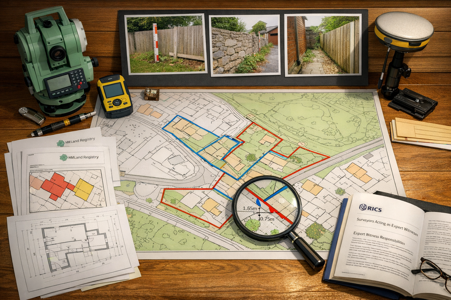
Step 1: Obtaining and Reviewing Documentary Evidence
The foundation of any boundary dispute case rests on comprehensive documentary research. Before conducting site surveys, expert witnesses must gather and analyze all relevant historical and legal documents [2].
Critical documents include:
| Document Type | Purpose | Source |
|---|---|---|
| Title Plans | Show registered boundary positions | HM Land Registry |
| Title Deeds | Contain conveyance descriptions | Solicitor/Land Registry |
| Historical Maps | Establish boundary evolution | Ordnance Survey archives |
| Planning Documents | Reveal approved boundary structures | Local authority |
| Previous Surveys | Provide historical measurement data | Property owners |
| Photographs | Document boundary changes over time | Multiple sources |
These documents should be compared systematically to identify discrepancies between legal descriptions and physical boundaries. The title plan from HM Land Registry, while not definitive for exact boundary positions, provides the starting point for investigation [2].
Expert Tip: Title plans show general boundary positions only. The red line on a Land Registry plan typically has a width of approximately 0.5-1.0 meters at scale, meaning the exact legal boundary could fall anywhere within that band.
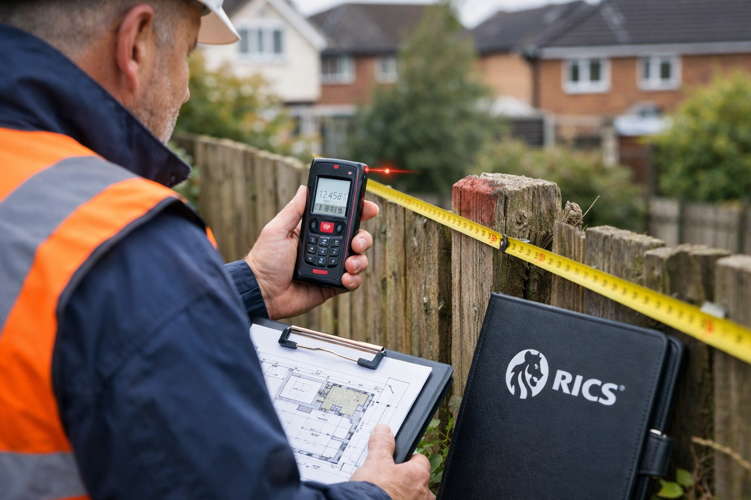
Step 2: Conducting Accurate Topographic Surveys
Topographic surveys undertaken by chartered land surveyors provide the most reliable technical evidence in boundary disputes [2]. These surveys record detailed information about existing physical boundaries with precision that meets RICS and HM Land Registry requirements.
Survey methodology must address:
📍 Accuracy Standards – Typically ±10mm for boundary features, though specific requirements depend on dispute context
📍 Reference Framework – Use of Ordnance Survey National Grid coordinates for absolute positioning
📍 Equipment Selection – Total stations, GPS receivers, or laser scanners appropriate to site conditions
📍 Feature Identification – Clear documentation of walls, fences, hedges, and other boundary markers
📍 Photographic Records – Comprehensive visual documentation linking survey data to physical features
The chartered land surveyor determines appropriate accuracy levels based on the dispute's specific purpose and the tribunal's requirements [2]. For residential boundary disputes, millimeter-level precision typically suffices, while larger commercial properties may require different standards.
Step 3: Analyzing Physical Evidence on Site
Beyond measurements, expert witnesses must evaluate the physical condition and history of boundary features. This analysis often reveals crucial evidence about boundary establishment and maintenance.
Key observations include:
- Age and condition of boundary structures (fences, walls, hedges)
- Maintenance patterns indicating ownership responsibility
- Encroachments or alterations to original boundary positions
- Ground levels and topography affecting boundary interpretation
- Vegetation patterns suggesting historical boundary lines
- Archaeological features such as old fence post holes or wall foundations
Experienced experts often conduct structural surveys to assess the integrity and age of boundary walls, which can provide evidence of long-standing boundary positions.
Expert Witness Strategies for Boundary Disputes in UK Properties: Preparing the Expert Report
RICS Standards for Expert Witness Reports
The expert witness report represents the formal presentation of findings and opinions to the tribunal. RICS standards specify precise requirements for report structure, content, and presentation [1].
Mandatory report elements:
- Statement of Truth – Declaration that the expert understands their duty to the court
- Qualifications and Experience – Detailed CV demonstrating relevant expertise
- Instructions Received – Clear statement of questions posed by instructing party
- Facts and Assumptions – Distinction between verified facts and working assumptions
- Investigation Methods – Description of surveys, tests, and research conducted
- Findings – Objective presentation of technical data and observations
- Opinions – Professional conclusions drawn from the evidence
- Range of Opinion – Acknowledgment of alternative interpretations where applicable
- Summary of Conclusions – Clear, accessible summary of key findings
- Supporting Documents – Appendices containing survey plans, photographs, and calculations
Each section must be written in clear, accessible language that non-technical tribunal members can understand. Technical jargon should be defined, and complex concepts explained with analogies or diagrams.
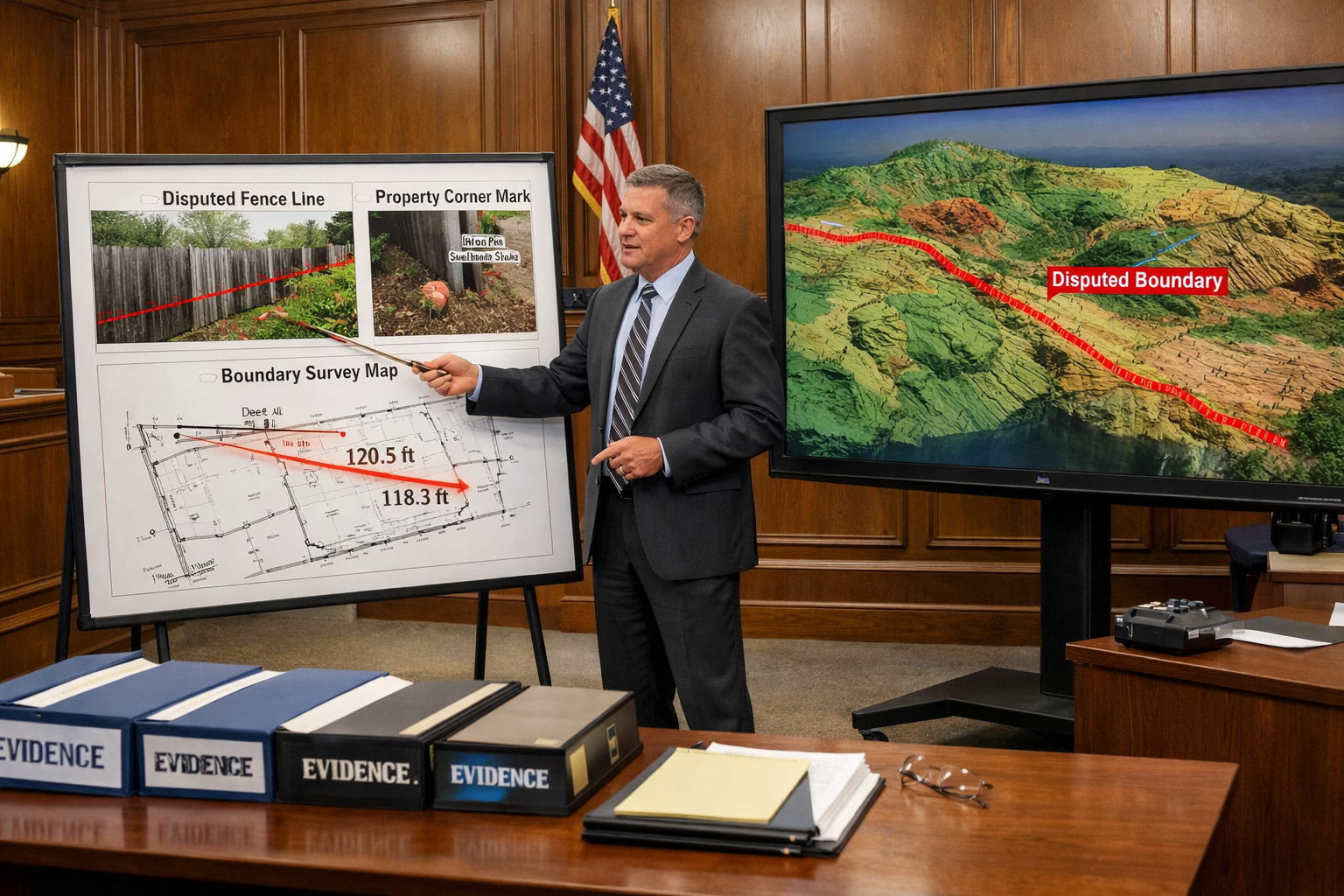
Presenting Survey Data Effectively
Raw survey data requires translation into compelling visual evidence. Expert witnesses typically prepare several presentation formats:
📊 Scaled Plans showing measured boundary positions overlaid on title plans
📸 Annotated Photographs with measurements and feature identification
📈 Cross-Sections illustrating ground levels and vertical boundary elements
🗺️ Overlay Comparisons demonstrating discrepancies between documents and physical features
📋 Measurement Tables providing precise dimensions with accuracy statements
These visual aids must be prepared to professional cartographic standards, with clear legends, scale bars, north points, and attribution. The goal is to enable tribunal members to understand complex spatial relationships without specialized knowledge.
For properties requiring detailed analysis, experts may commission RICS building surveys to document the condition of boundary structures comprehensively.
Addressing Uncertainty and Alternative Interpretations
Credible expert witnesses acknowledge limitations in available evidence and present alternative interpretations where reasonable. This transparency enhances rather than diminishes expert credibility [1].
Best practices include:
- Quantifying measurement uncertainties with confidence intervals
- Explaining factors that could affect interpretation (e.g., ground movement, historical alterations)
- Presenting competing theories when evidence supports multiple conclusions
- Clearly stating when definitive conclusions cannot be reached
- Recommending additional investigations if needed to resolve uncertainties
"The expert witness who admits the limits of their knowledge gains more credibility than one who claims absolute certainty in ambiguous situations."
Expert Witness Strategies for Boundary Disputes: Court Preparation and Testimony
Pre-Hearing Procedures and Expert Meetings
Before formal hearings, civil procedure often requires experts from opposing parties to meet and prepare a joint statement. This process, designed to narrow issues in dispute, follows specific protocols [1].
The expert meeting process:
- Without Prejudice Discussions – Experts discuss technical matters without legal representatives present
- Areas of Agreement – Identification of facts and opinions both experts accept
- Areas of Disagreement – Clear statement of remaining technical disputes
- Reasons for Disagreement – Explanation of why experts reach different conclusions
- Joint Statement – Formal document signed by both experts summarizing discussions
These meetings often resolve technical disagreements, allowing tribunals to focus on remaining legal questions. Experts must approach these discussions with genuine openness to alternative viewpoints while maintaining their independent professional judgment.
Delivering Effective Oral Testimony
When called to give evidence, expert witnesses must communicate technical findings clearly under examination and cross-examination. Preparation for this testimony is critical.
Testimony best practices:
💬 Speak to the Judge – Address answers to tribunal members, not questioning lawyers
💬 Use Plain Language – Avoid unnecessary jargon; explain technical terms when used
💬 Answer Directly – Respond to questions asked without evasion or over-elaboration
💬 Maintain Composure – Remain professional even under aggressive cross-examination
💬 Refer to Evidence – Base answers on documented evidence, not speculation
💬 Admit Limitations – Acknowledge when questions fall outside expertise or available evidence
💬 Request Clarification – Ask for questions to be repeated or clarified if unclear
Cross-examination aims to test the reliability of expert opinions. Well-prepared experts who have followed RICS standards and conducted thorough investigations typically withstand this scrutiny effectively.
Common Pitfalls and How to Avoid Them
Even experienced professionals can make mistakes that undermine their effectiveness as expert witnesses. Awareness of common pitfalls helps avoid them.
⚠️ Advocacy Bias – Becoming an advocate for the instructing party rather than maintaining independence
Solution: Regularly remind yourself that your duty is to the court, not the client
⚠️ Overconfidence – Claiming certainty when evidence supports only probable conclusions
Solution: Use qualified language ("likely," "probable") when appropriate and quantify uncertainties
⚠️ Inadequate Documentation – Failing to record methodology and observations comprehensively
Solution: Maintain detailed contemporaneous notes of all site visits and investigations
⚠️ Scope Creep – Offering opinions outside areas of genuine expertise
Solution: Clearly define the boundaries of your competence and decline to answer questions beyond them
⚠️ Poor Communication – Using technical language that tribunal members cannot understand
Solution: Prepare explanations of complex concepts in plain English before the hearing
Professionals offering expert witness services regularly update their skills through continuing professional development to avoid these pitfalls.
Integrating RICS Evidence Best Practices Throughout the Process
Compliance with Professional Standards
RICS standards provide the quality framework that distinguishes professional expert evidence from amateur opinions. Compliance with these standards is not optional for chartered surveyors acting as expert witnesses [1].
Key standards include:
- Terms of Engagement – Written agreement clarifying scope, fees, and duties before accepting instructions
- Independence Requirements – Procedures ensuring no conflicts of interest compromise objectivity
- Report Formatting – Specific structural requirements for expert reports
- Continuing Competence – Ongoing professional development in boundary law and surveying techniques
- Professional Indemnity Insurance – Adequate coverage for expert witness work
These standards align with Civil Procedure Rules and tribunal expectations, ensuring expert evidence meets admissibility requirements. Surveyors who deviate from RICS standards risk professional sanctions and may have their evidence excluded or given reduced weight.
Coordination with Legal Teams
While maintaining independence, expert witnesses must coordinate effectively with instructing solicitors to ensure evidence addresses the legal issues in dispute.
Effective coordination involves:
✔️ Clear Instructions – Ensuring questions posed are specific and answerable through surveying expertise
✔️ Regular Communication – Updating legal teams on investigation progress and preliminary findings
✔️ Evidence Disclosure – Timely provision of draft reports for legal review (while retaining final content control)
✔️ Trial Preparation – Collaborating on presentation strategies without compromising independence
✔️ Cost Management – Providing transparent fee estimates and avoiding unnecessary investigation
This collaboration works best when both expert and solicitor understand their distinct roles: the solicitor manages legal strategy while the expert provides independent technical evidence.
Staying Current with Regulatory Developments
The regulatory landscape for boundary disputes continues to evolve. In 2026, RICS launched consultations on the draft 8th edition of Party Wall Legislation and Procedure, inviting feedback from surveyors, legal professionals, and dispute resolution practitioners [3].
Expert witnesses must stay informed about:
- Changes to Land Registration rules affecting boundary determination
- Updates to RICS professional standards and guidance
- Emerging case law establishing precedents for boundary interpretation
- Technological advances in surveying equipment and techniques
- Best practice developments in expert witness methodology
Professional bodies, continuing education courses, and specialized publications provide channels for maintaining current knowledge. Experts who demonstrate awareness of recent developments enhance their credibility before tribunals.
For disputes involving party wall matters, staying current with the evolving legislative framework is particularly important.
Advanced Considerations in Complex Boundary Disputes
Dealing with Historical Boundary Changes
Many boundary disputes involve properties where boundaries have shifted over decades or centuries. Historical research becomes critical in these cases.
Research strategies include:
- Examining sequential Ordnance Survey maps from different editions
- Analyzing aerial photographs from various dates
- Investigating planning records for approved boundary alterations
- Reviewing previous conveyances predating current title registration
- Consulting local history archives for contextual information
This historical analysis often reveals patterns of gradual encroachment or identifies when significant boundary changes occurred. Expert witnesses must present this temporal evidence clearly, using timeline graphics and comparative overlays.
Technical Challenges: Adverse Possession Claims
Boundary disputes sometimes involve adverse possession claims, where one party asserts ownership through long-term occupation of disputed land. Expert witnesses must provide evidence regarding:
- Duration of occupation – Physical evidence of how long disputed land has been occupied
- Exclusivity – Whether occupation was exclusive or shared with the paper title owner
- Visibility – Whether occupation was obvious or concealed
- Intention – Physical evidence suggesting intention to possess (fencing, cultivation, structures)
While legal conclusions about adverse possession rest with the tribunal, expert evidence about physical occupation patterns is crucial to these determinations.
Multi-Party Disputes and Complex Boundaries
Some disputes involve multiple adjacent properties or complex boundary configurations. These cases require sophisticated survey techniques and clear presentation strategies.
Approaches include:
- Creating comprehensive site-wide surveys showing all relevant boundaries
- Preparing separate detailed plans for each disputed interface
- Using color-coding systems to distinguish different parties' claims
- Developing 3D visualizations for complex vertical boundaries
- Coordinating with multiple experts when disputes involve various technical issues
For properties with complex structural considerations, experts may need to coordinate with specialists providing structural engineering assessments.
Cost Considerations and Proportionality
Balancing Thoroughness with Proportionality
Expert investigations must be proportionate to the dispute's value and complexity. Tribunals increasingly scrutinize expert costs and may penalize parties for disproportionate expenditure.
Cost management strategies:
💰 Phased Investigations – Starting with basic surveys and expanding only if needed
💰 Clear Scope Definition – Agreeing investigation limits with instructing parties upfront
💰 Efficient Methodology – Using appropriate technology without unnecessary complexity
💰 Transparent Billing – Providing detailed time records and avoiding scope creep
💰 Early Settlement Focus – Identifying opportunities for resolution before full hearing
For straightforward residential boundary disputes, a basic topographic survey and report may suffice. Complex commercial disputes justify more extensive investigations. The key is matching effort to the case's requirements.
Alternative Dispute Resolution
Expert witnesses increasingly participate in mediation and other alternative dispute resolution processes. These informal settings require adapted approaches:
- Collaborative Problem-Solving – Working with opposing experts to find technical solutions
- Flexible Reporting – Providing informal technical opinions rather than full formal reports
- Real-Time Analysis – Offering immediate feedback on settlement proposals
- Cost-Benefit Guidance – Helping parties understand technical risks and litigation costs
Many boundary disputes resolve through mediation when experts provide clear, objective technical input that helps parties understand the strength of their positions.
Conclusion
Expert Witness Strategies for Boundary Disputes in UK Properties: RICS Evidence Best Practices provide the essential framework for resolving property boundary conflicts through credible, court-admissible evidence. The combination of rigorous documentary research, accurate topographic surveys, and professional presentation following RICS standards transforms technical surveying data into compelling evidence that tribunals can rely upon.
Key success factors include:
✅ Maintaining absolute independence and objectivity throughout the process
✅ Conducting investigations to RICS accuracy standards and professional protocols
✅ Preparing comprehensive reports that clearly distinguish facts from opinions
✅ Communicating complex technical matters in accessible language
✅ Staying current with regulatory developments and best practices
As boundary disputes continue to represent a significant source of neighbour conflict in 2026, the role of qualified expert witnesses becomes increasingly important. Property owners facing boundary disputes should engage RICS-qualified expert witnesses early in the process, as their objective technical evidence often facilitates settlement before costly litigation becomes necessary.
Actionable Next Steps
For Property Owners:
- Gather all available title documents, deeds, and historical records before consulting an expert
- Commission a topographic survey from a chartered land surveyor specializing in boundary disputes
- Seek early expert advice to understand the technical strength of your position
- Consider mediation with expert technical input before pursuing formal litigation
For Surveying Professionals:
5. Ensure compliance with current RICS expert witness standards through regular CPD
6. Develop clear terms of engagement templates that emphasize independence duties
7. Invest in accurate surveying equipment meeting HM Land Registry requirements
8. Build expertise in legal frameworks governing boundary determination
For Legal Professionals:
9. Instruct expert witnesses early to identify technical issues requiring investigation
10. Provide clear, specific questions that fall within surveying expertise
11. Facilitate expert meetings to narrow technical disputes before hearings
12. Ensure expert evidence is proportionate to the dispute's value and complexity
The technical complexity of boundary disputes demands professional expertise grounded in RICS standards. By following established best practices for evidence gathering, report preparation, and testimony delivery, expert witnesses provide the foundation for fair, evidence-based resolution of these contentious property conflicts.
References
[1] Surveyors Acting As Expert Witnesses – https://www.rics.org/profession-standards/rics-standards-and-guidance/sector-standards/dispute-resolution-standards/surveyors-acting-as-expert-witnesses
[2] Topographic Surveys And Boundary Disputes How To Establish Your Propertys Boundaries – https://www.rics.org/consumer-guides/topographic-surveys-and-boundary-disputes-how-to-establish-your-propertys-boundaries
[3] Home Survey Standard 2nd Edition April 2026 Update – https://www.rics.org/news-insights/home-survey-standard-2nd-edition-april-2026-update