The property surveying industry has witnessed a dramatic transformation in recent years, and 2026 marks a pivotal moment in this evolution. Drones in Property Surveying: Mastering UAV Applications for Accurate Topographic Mapping and Large-Scale Projects has shifted from an experimental approach to an industry-standard practice that delivers centimeter-level accuracy at a fraction of traditional costs. What once required teams of surveyors working for days across challenging terrain can now be accomplished in under an hour with a single unmanned aerial vehicle (UAV) equipped with advanced sensors and positioning technology.
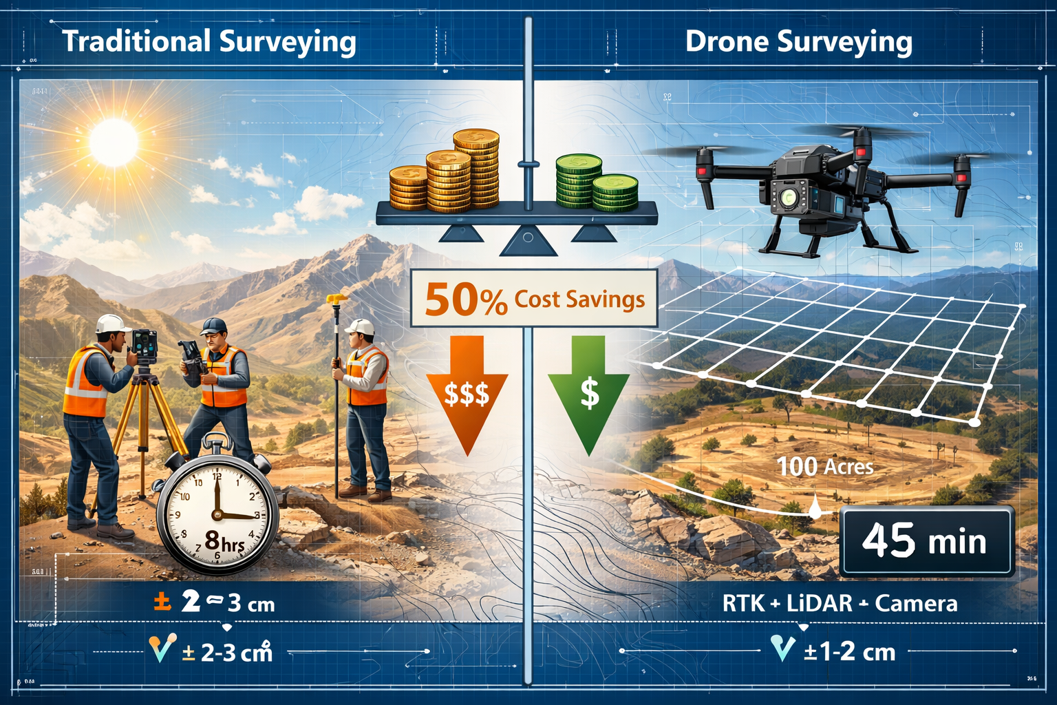
The numbers tell a compelling story: a drone can survey a 100-acre site in less than an hour, compared to traditional methods requiring multiple days and thousands of dollars in costs.[2] With RTK-enabled drones now delivering sub-5cm precision[2], surveying professionals are discovering that UAV applications aren't just faster—they're often more accurate than conventional ground-based methods. This comprehensive guide explores how surveyors can integrate drone technology into their workflows, comparing costs and accuracy against traditional methods while providing actionable steps for implementation.
Key Takeaways
- Modern surveying drones achieve centimeter-level accuracy through RTK/PPK positioning systems, matching or exceeding traditional ground survey precision at significantly lower costs
- Time efficiency improvements are dramatic: a single drone can complete 100-acre surveys in under one hour versus multiple days required for conventional methods[2]
- Multiple data outputs from single flights include orthomosaic maps, 3D terrain models, cut/fill analyses, thermal maps, and BIM-ready data[1][2]
- Regulatory landscape in 2026 continues evolving with improved frameworks that enhance accuracy, reduce costs, and simplify workflows[5]
- Integration requires strategic planning: successful UAV adoption involves equipment selection, pilot certification, workflow development, and quality control protocols
The Technology Revolution: How Drones Transformed Property Surveying
From Emerging Technology to Industry Standard
The journey of drones in property surveying represents one of the most significant technological shifts in land measurement history. Just a few years ago, UAV technology was prohibitively expensive and accessible only to large firms with substantial capital budgets. Today, the landscape has changed dramatically—drones have transitioned from luxury tools to standard options for surveying tasks, particularly for difficult terrain and hard-to-reach locations.[1]
This democratization of technology has fundamentally altered the economics of surveying. Where traditional ground surveys required extensive labor, expensive equipment, and significant time investments, modern drone systems deliver comparable or superior results with minimal personnel and compressed timelines.
Advanced Sensor Integration Capabilities
Modern surveying drones are equipped with high-resolution cameras and LiDAR sensors that capture massive datasets while performing surveys over expansive areas.[1] This dual-sensor approach enables surveyors to gather both photogrammetric and laser-scanning data simultaneously, creating redundancy and enhanced accuracy.
Key sensor technologies include:
- 📷 High-resolution RGB cameras (20+ megapixels) for detailed photogrammetry
- 🎯 LiDAR sensors capable of penetrating vegetation to capture ground surface
- 🌡️ Thermal imaging cameras for infrastructure assessment and moisture detection
- 📡 Multispectral sensors for vegetation analysis and environmental monitoring
- 🛰️ RTK/PPK GPS modules providing centimeter-level positioning accuracy
The integration of these sensors with advanced flight control systems allows surveyors to capture comprehensive site data that would have been impossible or impractical using traditional methods. For professionals conducting RICS building surveys, drone technology provides aerial perspectives that complement ground-level inspections.
Precision Standards Achieved in 2026
RTK-enabled drones have revolutionized accuracy expectations in the surveying industry. These systems now deliver sub-5cm precision through real-time kinematics (RTK) and post-processing kinematic (PPK) positioning.[2] This level of accuracy allows construction teams to verify earthwork, slab elevation, and utility placement with confidence that rivals or exceeds traditional total station measurements.
"Regulatory improvements combined with technological advances will lead to improved accuracy, reduced costs, and simplified workflows." — Industry experts on 2026 drone developments[5]
The precision achieved by modern UAV systems makes them suitable for applications previously reserved exclusively for ground-based surveying equipment. This includes boundary surveys, volumetric calculations, grade verification, and as-built documentation.
Cost and Time Comparison: Drones vs Traditional Surveying Methods
Breaking Down the Economics
Understanding the true cost differential between drone surveying and traditional methods requires examining multiple factors beyond simple equipment prices. The economic advantages of drones in property surveying become apparent when considering the total project lifecycle.
Traditional Ground Survey Costs:
| Cost Component | Typical Range | Notes |
|---|---|---|
| Equipment (Total Station/GPS) | $15,000 – $50,000 | Per unit, requires multiple for large sites |
| Personnel (3-person crew) | $800 – $1,500/day | Including benefits and overhead |
| Time for 100-acre site | 3-7 days | Weather and terrain dependent |
| Transportation & Setup | $200 – $500/day | Vehicle, fuel, accommodation |
| Total Project Cost | $5,000 – $12,000 | For typical large-scale survey |
Drone Survey Costs:
| Cost Component | Typical Range | Notes |
|---|---|---|
| Drone System (RTK-enabled) | $5,000 – $25,000 | One-time investment, multi-project use |
| Personnel (1-2 operators) | $400 – $800/day | Reduced crew requirements |
| Time for 100-acre site | 1-3 hours | Including setup and flight |
| Processing Software | $150 – $500/month | Subscription-based platforms |
| Total Project Cost | $1,000 – $3,000 | For typical large-scale survey |
The documented savings are substantial. One real-world case at the Halawa View Apartments project in Hawaii showed that drone mapping reduced documentation time by half and became so integral that missing regular scans raised internal concerns.[2]
Time Efficiency Gains
The time savings delivered by UAV technology extend beyond simple flight duration. Consider the complete workflow comparison:
Traditional Survey Timeline:
- ⏰ Site reconnaissance and access negotiation (1-2 days)
- ⏰ Equipment mobilization and setup (0.5-1 day)
- ⏰ Field data collection (2-5 days for 100 acres)
- ⏰ Data processing and CAD drafting (2-3 days)
- ⏰ Quality control and deliverable preparation (1 day)
Total: 6-12 days
Drone Survey Timeline:
- ⏰ Flight planning and regulatory compliance (2-4 hours)
- ⏰ Ground control point placement (2-4 hours)
- ⏰ Flight operations and data capture (1 hour)
- ⏰ Automated processing and model generation (4-8 hours)
- ⏰ Quality control and deliverable preparation (4 hours)
Total: 2-3 days
Documented real-world applications show that drone mapping can replace a full day of manual inspections with a 15-minute drone flight, saving five man-hours per site visit.[2] This efficiency gain becomes exponentially valuable for projects requiring regular monitoring throughout construction phases.
Accuracy Comparison Across Applications
While cost and time savings are compelling, accuracy remains the paramount concern for professional surveyors. Modern drone systems have proven their capability to meet or exceed traditional surveying accuracy standards across various applications:
Vertical Accuracy:
- Traditional GPS/Total Station: ±2-5cm
- RTK Drone Photogrammetry: ±3-5cm
- RTK Drone with LiDAR: ±2-4cm
Horizontal Accuracy:
- Traditional GPS/Total Station: ±2-3cm
- RTK Drone Photogrammetry: ±2-5cm
- RTK Drone with LiDAR: ±2-4cm
The key to achieving these accuracy levels lies in proper ground control point (GCP) placement, appropriate flight planning, and rigorous post-processing workflows. When these protocols are followed, drone surveys consistently deliver results that meet professional surveying standards for most applications, including those required for structural engineering projects.
Step-by-Step Guide: Integrating UAVs into Surveying Workflows
Phase 1: Equipment Selection and Acquisition
Successful integration of drones in property surveying begins with selecting the right equipment for your specific applications and project requirements. The market offers numerous options ranging from consumer-grade devices to professional surveying platforms.
Essential Equipment Components:
✅ Primary UAV Platform
- RTK/PPK-enabled drone for centimeter-level accuracy
- Minimum 30-minute flight time for efficient coverage
- Obstacle avoidance systems for safety
- Weather resistance for operational flexibility
✅ Sensor Payload
- High-resolution RGB camera (20MP minimum)
- Optional LiDAR for vegetation penetration
- Thermal or multispectral sensors for specialized applications
✅ Ground Control Equipment
- Survey-grade GPS base station or NTRIP subscription
- Ground control point markers and targets
- Measuring tools for GCP coordinate verification
✅ Processing Software
- Photogrammetry platform (DroneDeploy, Pix4D, Agisoft Metashape)
- CAD integration tools
- Cloud storage and collaboration platforms
Note on Regulatory Compliance: Existing DJI drones that have received FCC approval remain unaffected by current regulatory actions, though surveyors should stay informed about evolving restrictions on foreign-made drones.[8]
Phase 2: Pilot Certification and Training
Operating drones for commercial surveying requires proper certification and ongoing skill development. The regulatory framework in 2026 continues to evolve, with key regulatory changes affecting the drone industry aimed at improving accuracy, reducing costs, and simplifying workflows.[5]
Certification Requirements:
- Remote Pilot Certificate – Required for commercial operations
- Part 107 Waiver – For operations beyond visual line of sight (if needed)
- Manufacturer-Specific Training – Platform operational proficiency
- Surveying-Specific Skills – Understanding accuracy requirements and quality control
Recommended Training Path:
📚 Complete FAA Part 107 ground school and examination
📚 Attend manufacturer flight training programs
📚 Practice flight operations in controlled environments
📚 Shadow experienced drone surveyors on actual projects
📚 Develop expertise in photogrammetry processing software
📚 Understand surveying principles and accuracy standards
Phase 3: Pre-Flight Planning and Site Preparation
Thorough planning distinguishes professional surveying operations from casual drone photography. This phase determines the ultimate accuracy and completeness of survey deliverables.
Flight Planning Checklist:
🔲 Site Analysis
- Review existing maps and aerial imagery
- Identify obstacles, hazards, and no-fly zones
- Assess terrain characteristics and elevation changes
- Determine optimal ground control point locations
🔲 Regulatory Compliance
- Verify airspace authorization requirements
- Obtain necessary permissions from property owners
- File NOTAM if required for the operation
- Ensure compliance with local regulations
🔲 Mission Parameters
- Calculate required overlap (typically 70-80% frontal, 60-70% side)
- Determine optimal flight altitude for desired ground sample distance
- Plan flight paths for complete coverage with minimal gaps
- Calculate battery requirements and plan for swaps if needed
🔲 Ground Control Strategy
- Design GCP distribution pattern (minimum 5 points, ideally 8-12)
- Plan GCP placement for optimal accuracy
- Prepare survey-grade GPS equipment for coordinate capture
- Create GCP markers visible from flight altitude
For surveyors working on commercial building surveys, drone data provides valuable context for understanding site conditions and building relationships to surrounding features.
Phase 4: Field Operations and Data Capture
Efficient field operations maximize the time and cost advantages that make drone surveying attractive. Proper execution during this phase ensures high-quality data suitable for professional deliverables.
Field Operations Workflow:
Step 1: Ground Control Point Deployment
- Place GCP markers at predetermined locations
- Ensure targets are clearly visible and securely positioned
- Capture precise coordinates using survey-grade GPS
- Document GCP locations with photos and field notes
Step 2: Pre-Flight Procedures
- Verify weather conditions meet operational requirements
- Conduct equipment inspection and functionality checks
- Establish RTK/PPK connection and verify positioning accuracy
- Brief team members on safety protocols and communication procedures
Step 3: Flight Execution
- Launch autonomous mission with planned parameters
- Monitor flight progress and data capture quality
- Adjust parameters if coverage gaps or issues detected
- Capture oblique imagery for vertical features if required
Step 4: Quality Assurance
- Review captured imagery for completeness and quality
- Verify adequate overlap and coverage
- Check GCP visibility in captured images
- Conduct additional flights if gaps or quality issues identified
The rapid deployment capabilities of modern drones allow a single operator to survey a 100-acre site in less than an hour[2], but rushing through quality assurance steps can compromise the entire dataset.
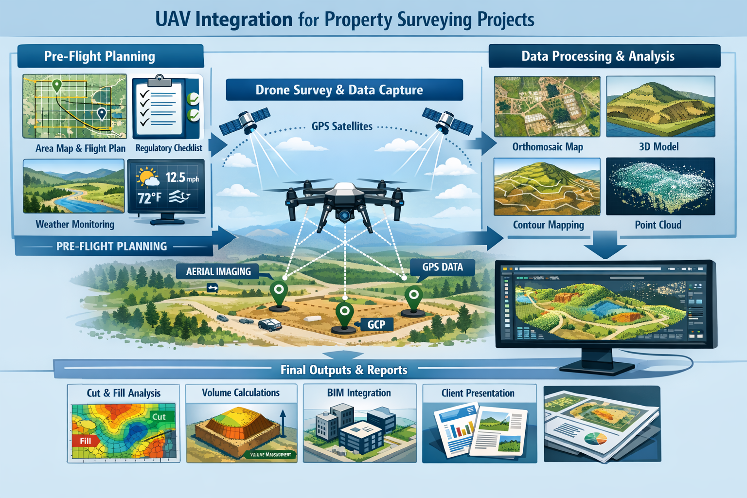
Phase 5: Post-Processing and Deliverable Generation
The captured imagery and sensor data must be processed into usable surveying deliverables. This phase transforms raw data into the multiple data products that modern drone systems can generate from a single flight.[1][2]
Processing Workflow:
1️⃣ Data Import and Organization
- Transfer imagery and flight logs to processing workstation
- Import ground control point coordinates
- Organize files according to project structure
- Create backup copies of raw data
2️⃣ Initial Processing
- Import images into photogrammetry software
- Align photos and generate sparse point cloud
- Identify and mark GCPs in imagery
- Optimize camera positions and verify accuracy
3️⃣ Dense Reconstruction
- Generate dense point cloud from aligned imagery
- Create digital surface model (DSM) and digital terrain model (DTM)
- Produce orthomosaic map with corrected geometry
- Extract 3D mesh models if required
4️⃣ Analysis and Deliverable Creation
Modern drone systems can generate comprehensive outputs including:
📊 Orthomosaic maps – Geometrically corrected aerial imagery
📊 3D terrain models – Detailed surface representations
📊 Cut/fill analyses – Volumetric calculations for earthwork
📊 Multispectral maps – Vegetation and environmental analysis
📊 Thermal maps – Infrastructure assessment data
📊 Building Information Modeling (BIM) data – Integration with design platforms[1][2]
5️⃣ Quality Control and Validation
- Verify accuracy against ground control points
- Check for processing artifacts or errors
- Validate measurements against known dimensions
- Generate accuracy reports and metadata
For professionals conducting different types of surveys, drone data can complement traditional methods and provide additional context for decision-making.
Phase 6: Integration with Existing Workflows
The final step in mastering UAV applications for accurate topographic mapping involves seamlessly integrating drone-derived data into established surveying and design workflows.
Integration Strategies:
🔗 CAD Platform Integration
- Import point clouds and orthomosaics into AutoCAD Civil 3D
- Generate contour lines and cross-sections from terrain models
- Create boundary surveys and topographic maps
- Produce construction staking plans
🔗 BIM Workflow Integration
- Export 3D models in formats compatible with Revit and other BIM platforms
- Use point clouds as reference data for as-built modeling
- Verify design intent against actual site conditions
- Support clash detection and coordination processes
🔗 GIS Platform Integration
- Import georeferenced orthomosaics into ArcGIS or QGIS
- Conduct spatial analysis using drone-derived data
- Create layered maps combining drone data with other sources
- Support planning and environmental assessment workflows
🔗 Progress Monitoring Systems
Beyond initial surveys, regular drone flights during construction can monitor project progress, compare actual builds against digital blueprints, verify safety compliance, and create visual documentation of the entire project lifecycle.[4]
Mastering UAV Applications for Large-Scale Projects
Topographic Mapping at Scale
Drones in property surveying excel particularly in large-scale topographic mapping applications where traditional methods face significant challenges. The combination of rapid data capture, comprehensive coverage, and high accuracy makes UAVs ideal for extensive land development projects.
Large-Scale Project Considerations:
🏗️ Site Size Management
- Projects exceeding 500 acres may require multiple flight sessions
- Battery management becomes critical for extended operations
- Ground control point distribution must maintain accuracy across entire site
- Processing requirements increase significantly with dataset size
🏗️ Accuracy Maintenance
- RTK/PPK positioning essential for large-area consistency
- GCP density should increase proportionally with site size
- Checkpoints separate from control points verify accuracy
- Systematic error identification and correction protocols
🏗️ Data Management
- Large projects generate terabytes of imagery and point cloud data
- Cloud-based processing platforms handle datasets exceeding local capacity
- File organization and version control become critical
- Long-term data storage and archival strategies required
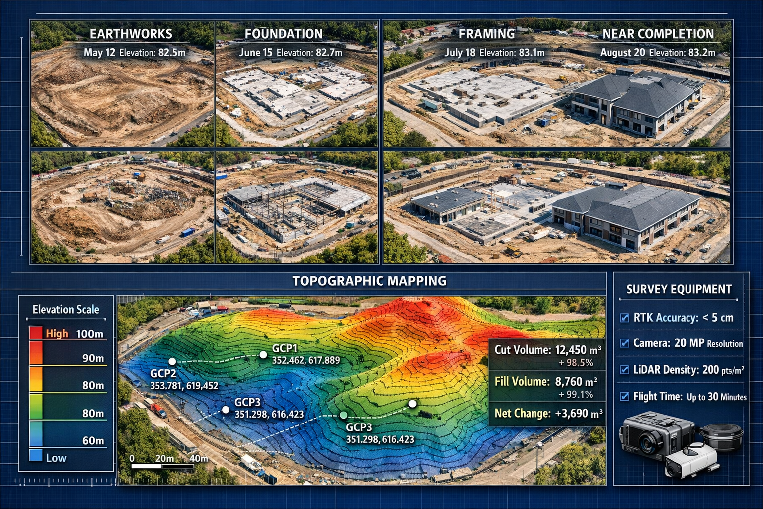
Construction Progress Monitoring
The ability to rapidly capture comprehensive site data makes drones invaluable for construction monitoring throughout project lifecycles. Regular flights create temporal datasets that track changes and verify progress against schedules.
Progress Monitoring Applications:
📈 Earthwork Verification
- Compare actual cut/fill volumes against design specifications
- Identify discrepancies early in construction process
- Generate payment documentation based on completed quantities
- Track stockpile volumes and material movements
📈 Foundation and Structural Progress
- Verify slab elevations and foundation placement
- Document construction sequencing and methods
- Create as-built records for quality assurance
- Support coordination between trades and disciplines
📈 Safety and Compliance Monitoring
- Identify potential safety hazards from aerial perspective
- Verify erosion control and environmental protection measures
- Document site conditions for regulatory compliance
- Create visual records for dispute resolution
The National Weather Service and Disaster Imaging, Inc. established a Cooperative Research and Development Agreement (CRADA) to rapidly deploy uncranned aircraft systems (UAS) for post-storm damage assessments[3], demonstrating how drone technology extends beyond routine surveying into emergency response applications.
Infrastructure Assessment and Maintenance
Drone technology has revolutionized infrastructure inspection and assessment, providing safe access to structures that would otherwise require expensive equipment or dangerous working conditions.
Infrastructure Applications:
🏢 Building Envelope Inspection
- Detailed facade assessment without scaffolding
- Thermal imaging for moisture intrusion detection
- Roof condition surveys and damage documentation
- Window and cladding system evaluation
🏢 Civil Infrastructure Assessment
- Bridge inspection and structural evaluation
- Dam and reservoir monitoring
- Power line and tower inspection
- Pipeline corridor surveillance
🏢 Asset Management
- Regular condition monitoring creating historical records
- Predictive maintenance planning based on observed deterioration
- Quantification of repair needs and cost estimation
- Documentation for insurance and liability purposes
For surveyors conducting roof surveys, drones provide detailed imagery and thermal data that would be difficult or dangerous to obtain through traditional access methods.
Advanced Applications and Emerging Capabilities
Multispectral and Thermal Imaging
Beyond standard RGB photography, specialized sensors expand the capabilities of surveying drones into environmental monitoring and infrastructure assessment applications.
Multispectral Applications:
🌱 Vegetation Analysis
- NDVI (Normalized Difference Vegetation Index) mapping
- Crop health monitoring for agricultural properties
- Landscape management and irrigation planning
- Environmental impact assessment
🌱 Environmental Monitoring
- Water quality assessment through spectral analysis
- Wetland delineation and monitoring
- Invasive species identification and tracking
- Habitat assessment and ecological studies
Thermal Imaging Applications:
🌡️ Building Performance
- Energy efficiency assessment through heat loss detection
- Moisture intrusion identification in building envelopes
- HVAC system performance evaluation
- Solar panel efficiency monitoring
🌡️ Infrastructure Monitoring
- Electrical system hotspot detection
- Pipeline leak identification
- Pavement condition assessment
- Underground utility location
LiDAR Integration for Enhanced Accuracy
While photogrammetry excels in many applications, LiDAR sensors provide unique capabilities that complement or surpass camera-based systems in specific scenarios.
LiDAR Advantages:
⚡ Vegetation Penetration – Laser pulses reach ground surface beneath tree canopy
⚡ Consistent Accuracy – Less affected by lighting conditions and surface texture
⚡ Direct 3D Measurement – Captures precise point clouds without image processing
⚡ Feature Extraction – Automated identification of power lines, buildings, and terrain features
Optimal LiDAR Applications:
- Forested areas requiring bare-earth terrain models
- Utility corridor mapping with vegetation challenges
- Archaeological site documentation
- Flood modeling requiring precise elevation data
- Transportation corridor surveys with complex features
The integration of LiDAR with traditional photogrammetry creates hybrid datasets that leverage the strengths of both technologies, providing comprehensive site documentation suitable for demanding engineering applications.
Automated Processing and AI Integration
The future of drones in property surveying increasingly involves artificial intelligence and machine learning technologies that automate data processing and feature extraction.
AI-Enhanced Capabilities:
🤖 Automated Feature Recognition
- Building footprint extraction from imagery
- Utility pole and line identification
- Vegetation classification and mapping
- Change detection between temporal datasets
🤖 Quality Control Automation
- Automated accuracy verification against control points
- Image quality assessment and flagging
- Processing error identification and correction
- Deliverable validation against specifications
🤖 Predictive Analytics
- Construction progress prediction based on historical trends
- Maintenance needs forecasting from condition data
- Risk assessment for infrastructure assets
- Project timeline optimization
These advanced capabilities are transforming drone surveying from a data capture tool into an intelligent analysis platform that provides actionable insights beyond simple measurements.
Regulatory Landscape and Compliance in 2026
Current Regulatory Framework
Understanding and complying with aviation regulations remains essential for professional drone surveying operations. The regulatory environment in 2026 continues to evolve, with improvements aimed at balancing safety with operational flexibility.
Key Regulatory Considerations:
📋 Part 107 Commercial Operations
- Remote pilot certification required for commercial surveying
- Visual line of sight requirements (waivers available)
- Altitude limitations (400 feet AGL standard)
- Daylight operations (waiver required for night flights)
📋 Airspace Authorization
- LAANC (Low Altitude Authorization and Notification Capability) for controlled airspace
- Automatic approvals available in many areas
- Manual authorization required for complex airspace
- Temporary flight restrictions must be observed
📋 Privacy and Property Rights
- Property owner permission required for survey operations
- Privacy considerations for residential areas
- Data security and client confidentiality
- Professional liability and insurance requirements
As of January 2026, key regulatory changes affecting the drone industry are underway, with industry experts noting that regulatory improvements combined with technological advances will lead to "improved accuracy, reduced costs, and simplified workflows."[5]
Best Practices for Regulatory Compliance
Maintaining compliance while operating efficiently requires systematic approaches to regulatory requirements.
Compliance Best Practices:
✓ Pre-Flight Authorization
- Verify airspace classification for every project location
- Obtain LAANC authorization before arriving on site
- Document all permissions and authorizations
- Maintain current remote pilot certification
✓ Operational Documentation
- Maintain flight logs for all operations
- Document weather conditions and operational decisions
- Record maintenance and equipment inspections
- Create standard operating procedures for common scenarios
✓ Risk Management
- Conduct site-specific risk assessments
- Implement safety protocols for all operations
- Maintain appropriate insurance coverage
- Develop emergency response procedures
✓ Continuing Education
- Stay informed about regulatory changes
- Participate in industry associations and forums
- Attend training on new technologies and methods
- Maintain awareness of local regulations and restrictions
For surveyors conducting property valuations, drone-derived data can provide valuable context and documentation to support valuation conclusions.
Overcoming Common Challenges and Limitations
Weather and Environmental Constraints
While drones offer significant advantages, they face limitations that traditional surveying methods may not encounter.
Weather Challenges:
☁️ Wind Limitations
- Most surveying drones operate safely in winds up to 25-30 mph
- Higher winds reduce flight time and affect image quality
- Gusts can compromise positioning accuracy
- Coastal and mountain environments present particular challenges
☁️ Precipitation Restrictions
- Most drones cannot operate in rain or snow
- Moisture can damage electronics and sensors
- Wet surfaces affect photogrammetry accuracy
- Post-storm operations require equipment inspection
☁️ Lighting Conditions
- Optimal lighting occurs during mid-morning to mid-afternoon
- Shadows can create processing challenges
- Overcast conditions provide even lighting but reduce contrast
- Seasonal variations affect available operating windows
Mitigation Strategies:
- Schedule flights during optimal weather windows
- Maintain backup dates for weather contingencies
- Use RTK/PPK systems to minimize weather-related delays
- Consider LiDAR for operations in challenging lighting conditions
Technical Limitations and Accuracy Constraints
Understanding the limitations of drone surveying helps set appropriate expectations and determine when traditional methods remain preferable.
Accuracy Limitations:
⚠️ Vertical Feature Challenges
- Photogrammetry struggles with sheer vertical surfaces
- Building facades may require oblique imagery
- Underhangs and overhangs create occlusion issues
- Dense vegetation obscures ground surface
⚠️ Ground Sample Distance Trade-offs
- Lower flight altitudes increase accuracy but reduce coverage
- Higher altitudes improve efficiency but decrease detail
- Optimal altitude balances accuracy requirements with operational efficiency
- Feature size determines minimum acceptable GSD
⚠️ Processing Limitations
- Featureless surfaces (water, snow, uniform pavement) challenge photogrammetry
- Reflective surfaces create processing artifacts
- Moving objects appear distorted in final models
- Large datasets require significant processing time and computing resources
Integration with Traditional Methods
The most effective surveying approaches often combine drone technology with traditional ground-based methods, leveraging the strengths of each approach.
Hybrid Workflow Strategies:
🔄 Complementary Data Collection
- Use drones for overall site topography and context
- Employ total stations for precise boundary surveys
- Apply GPS for ground control and verification
- Utilize traditional methods for areas with drone limitations
🔄 Quality Verification
- Cross-check drone-derived elevations with ground measurements
- Verify critical dimensions using traditional equipment
- Use independent methods for high-stakes measurements
- Maintain professional surveying standards across all methods
🔄 Client Communication
- Educate clients about appropriate applications for each method
- Set realistic expectations for accuracy and deliverables
- Explain cost-benefit trade-offs for different approaches
- Provide transparent accuracy reporting
For professionals conducting building surveys, combining drone aerial data with detailed ground-level inspections creates comprehensive assessment documentation.
Future Trends and Emerging Technologies
Autonomous Operations and Beyond Visual Line of Sight
The surveying industry is moving toward increasingly autonomous drone operations that reduce operator workload and expand operational capabilities.
Emerging Autonomous Capabilities:
🚁 Automated Mission Planning
- AI-driven flight path optimization
- Automatic obstacle detection and avoidance
- Adaptive missions responding to site conditions
- Multi-drone coordinated operations
🚁 Beyond Visual Line of Sight (BVLOS)
- Extended range operations for large sites
- Remote monitoring and control
- Automated battery swapping and charging
- Continuous monitoring applications
🚁 Edge Processing
- Real-time data processing during flight
- Immediate quality verification and gap detection
- On-site deliverable generation
- Reduced post-processing requirements
Integration with Digital Twin Technologies
The convergence of drone surveying with digital twin platforms creates persistent digital representations of physical assets that update continuously throughout their lifecycles.
Digital Twin Applications:
🏗️ Construction Digital Twins
- Real-time progress tracking against 4D schedules
- Automated variance detection and reporting
- Integration with project management platforms
- Predictive analytics for schedule and cost
🏗️ Facility Management Digital Twins
- As-built documentation automatically updated
- Maintenance planning based on actual conditions
- Energy performance modeling and optimization
- Space utilization analysis and planning
🏗️ Infrastructure Digital Twins
- Continuous condition monitoring and assessment
- Predictive maintenance scheduling
- Performance optimization and analysis
- Risk assessment and mitigation planning
Sensor Technology Advancements
Ongoing sensor development continues expanding the capabilities and applications of surveying drones.
Emerging Sensor Technologies:
📡 Hyperspectral Imaging – Hundreds of spectral bands for detailed material identification
📡 Quantum Sensors – Enhanced sensitivity for geophysical surveys
📡 Synthetic Aperture Radar – All-weather imaging capabilities
📡 Gas Detection Sensors – Environmental monitoring and leak detection
These advanced sensors will enable surveying applications that extend far beyond traditional topographic mapping, creating new service opportunities for forward-thinking surveying professionals.
Conclusion: Embracing the Future of Property Surveying
The integration of drones in property surveying represents far more than a technological upgrade—it fundamentally transforms how surveying professionals approach their work. The combination of centimeter-level accuracy, dramatic time savings, and comprehensive data outputs has established UAV technology as an essential tool for modern surveying practices.
The evidence is compelling: drones can survey 100-acre sites in under an hour with sub-5cm precision[2], generate multiple data products from single flights[1][2], and reduce project costs by 60-80% compared to traditional methods. These advantages extend across applications from topographic mapping and construction monitoring to infrastructure assessment and environmental analysis.
However, success requires more than simply purchasing equipment. Mastering UAV applications for accurate topographic mapping and large-scale projects demands systematic integration of technology, training, workflows, and quality control protocols. The step-by-step approach outlined in this guide provides a roadmap for surveyors ready to embrace this transformation.
Actionable Next Steps
For surveying professionals ready to integrate drone technology into their practices:
1. Assess Your Current Needs
- Identify projects that would benefit most from drone surveying
- Evaluate current methods and pain points
- Calculate potential ROI for drone integration
- Determine appropriate equipment specifications
2. Invest in Training and Certification
- Obtain remote pilot certification
- Complete manufacturer-specific training programs
- Develop photogrammetry processing skills
- Build expertise through practice and mentorship
3. Start Small and Scale Gradually
- Begin with straightforward projects to build confidence
- Develop standard operating procedures
- Refine workflows based on experience
- Expand capabilities as expertise grows
4. Maintain Professional Standards
- Implement rigorous quality control protocols
- Verify accuracy against traditional methods
- Document procedures and maintain records
- Stay current with regulatory requirements
5. Embrace Continuous Learning
- Monitor emerging technologies and capabilities
- Participate in industry associations and forums
- Attend conferences and training events
- Share knowledge and learn from peers
The regulatory landscape in 2026 continues evolving toward frameworks that support innovation while maintaining safety standards.[5] Surveying professionals who invest in developing UAV capabilities now position themselves to lead the industry's ongoing transformation.
The future of property surveying combines the precision and professional standards of traditional methods with the efficiency and comprehensive data capture of modern drone technology. Those who master this integration will deliver superior value to clients while building more efficient, profitable, and competitive surveying practices.
The sky is no longer the limit—it's the new frontier for surveying excellence. The question is not whether to integrate drone technology, but how quickly you can master its applications to serve your clients better and advance your professional practice.
For surveyors seeking to expand their service offerings, drone technology complements traditional surveying services and creates new opportunities for comprehensive property assessment and documentation.
References
[1] The Future Of Land Surveying Technology And Upcoming Trends In 2026 – https://metricop.com/blogs/land-surveying/the-future-of-land-surveying-technology-and-upcoming-trends-in-2026
[2] The Rise Of Drone Mapping In Construction Speed Accuracy And Efficiency From The Sky – https://www.dronedeploy.com/blog/the-rise-of-drone-mapping-in-construction-speed-accuracy-and-efficiency-from-the-sky
[3] Surveying Storm Damage Noaa Research And Development Agreement With Disaster Imaging Inc Promises To Leverage Drone Technology For Post Storm Damage Assessments – https://techpartnerships.noaa.gov/surveying-storm-damage-noaa-research-and-development-agreement-with-disaster-imaging-inc-promises-to-leverage-drone-technology-for-post-storm-damage-assessments/
[4] The Increasing Role Of Drones In Industry – https://www.global-aero.com/the-increasing-role-of-drones-in-industry/
[5] Three Things Geospatial Professionals Should Know About The Drone Industry In 2026 – https://www.geoweeknews.com/news/three-things-geospatial-professionals-should-know-about-the-drone-industry-in-2026
[6] Revolutionizing Land Surveying The Rise Of Drone Technology And Uav Applications In 2026 – https://nottinghillsurveyors.com/blog/revolutionizing-land-surveying-the-rise-of-drone-technology-and-uav-applications-in-2026
[7] The Real Role Of Drones In Property Surveys And Inspections – https://propmodo.com/the-real-role-of-drones-in-property-surveys-and-inspections/
[8] Dji Ban – https://uavcoach.com/dji-ban/