Over 60% of neighbour disputes in England and Wales involve some element of boundary uncertainty — yet the majority could be resolved before reaching court if the right survey evidence were gathered and presented correctly. In 2026, the methodology for doing exactly that has become more precise, more technology-driven, and more legally demanding than ever before. Boundary surveys in expert witness roles: combining site measurements with Land Registry data for 2026 disputes sits at the intersection of technical surveying practice and civil litigation procedure — and getting it right can mean the difference between a swift resolution and years of costly legal conflict.
Key Takeaways 📌
- Expert witness surveyors perform three core functions: authenticating documents, explaining methodology, and rendering boundary conclusions [1]
- Combining physical site measurements with Land Registry data creates a far stronger evidential base than either source alone
- Modern tools — including GPS, total stations, and drone surveys — dramatically improve measurement accuracy for dispute evidence
- Civil Procedure Rules (CPR) Part 35 governs how expert evidence must be prepared and presented in English courts
- Early engagement of a qualified surveying expert can prevent litigation entirely by establishing clear, defensible boundary positions
What Does an Expert Witness Surveyor Actually Do?
The role of a surveyor acting as an expert witness is distinct from that of a standard property surveyor. Rather than simply measuring and reporting for a client's benefit, an expert witness surveyor owes a primary duty to the court — not to the instructing party. This is a critical legal and ethical distinction.
According to established practice, expert witness surveyors provide three core functions in litigation [1]:
- Identifying and authenticating relevant documents — including title deeds, historical maps, and Land Registry records
- Explaining how boundary-fixing methodology works — translating technical survey data into language a judge or mediator can understand
- Rendering conclusions on boundary locations — offering a professional opinion on where the legal boundary lies, supported by evidence
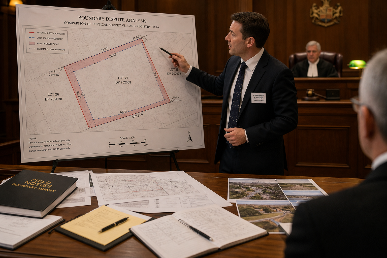
For parties involved in a boundary dispute, engaging a specialist is essential. The expert witness surveying services provided by qualified chartered surveyors are specifically designed to meet CPR Part 35 requirements — the Civil Procedure Rules that govern expert evidence in English civil courts.
Standard Materials Used in Expert Testimony
Expert witness surveyors typically rely on a defined set of materials when preparing their reports [3]:
| Material | Purpose |
|---|---|
| Survey plats and plans | Visual representation of boundary positions |
| Field notes | Raw measurement data from site visits |
| Boundary calculations | Mathematical derivation of line positions |
| Prior survey reports | Historical context and comparison |
| Photographs | Visual evidence of physical features |
| Land Registry title plans | Official registered boundary data |
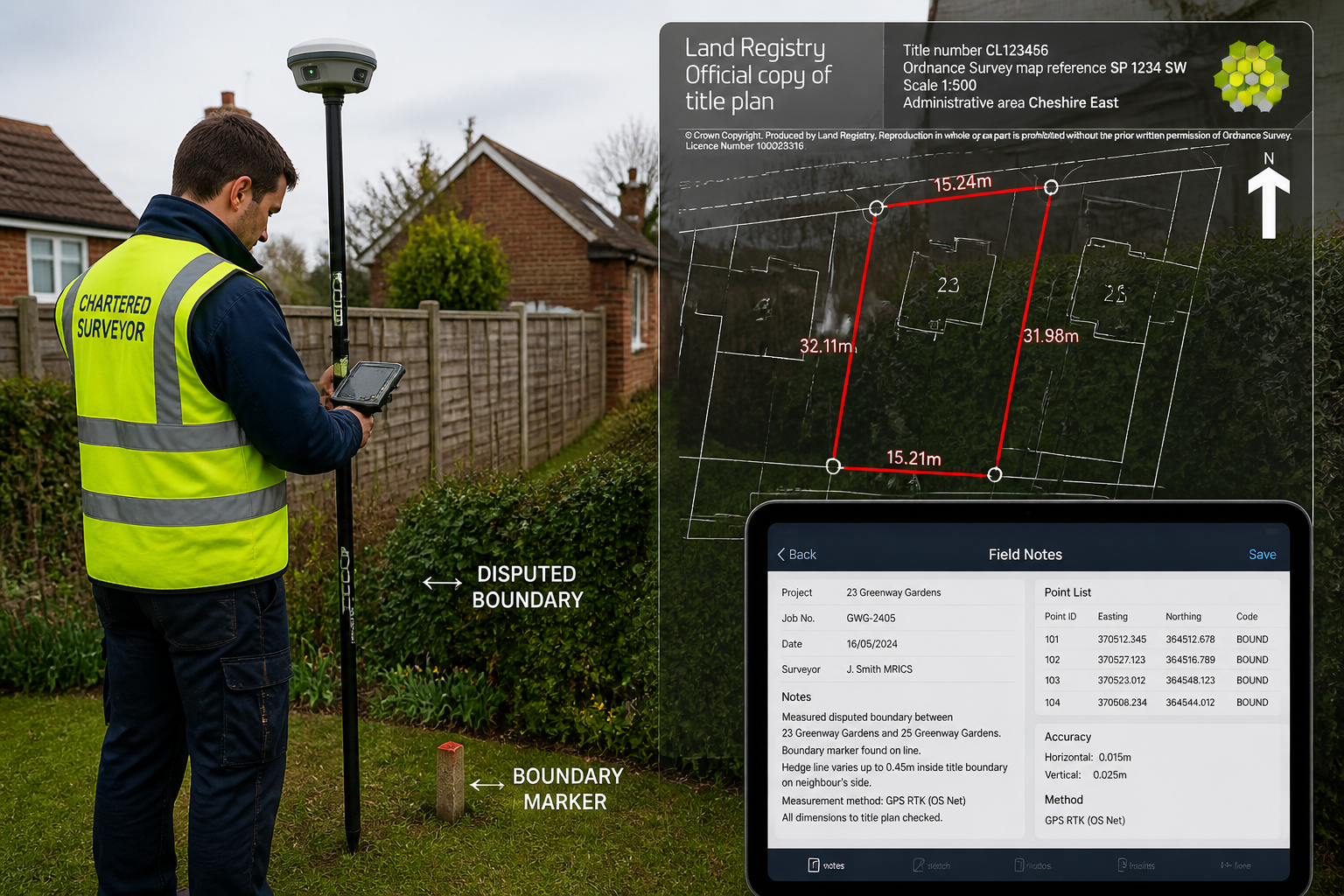
Combining Site Measurements with Land Registry Data: The Core Methodology
The phrase "combining site measurements with Land Registry data" describes the central technical challenge in boundary dispute work. Neither source of information is sufficient on its own — and understanding why is key to appreciating how expert surveyors build their evidence.
Why Land Registry Data Alone Is Not Enough
Land Registry title plans in England and Wales are drawn to a general boundary rule. This means the red line on a title plan indicates the approximate position of a boundary — it does not define the precise legal boundary to the millimetre. HM Land Registry itself acknowledges that title plans are based on Ordnance Survey mapping, which carries an inherent accuracy tolerance.
💡 Pull Quote: "The red line on a title plan is a starting point, not a finishing line. Expert surveyors must go further — to the ground itself."
This means that in any serious dispute, relying solely on the title plan is legally insufficient. Courts expect expert witnesses to go beyond the register and investigate physical evidence on site.
Why Site Measurements Alone Are Not Enough
Conversely, physical site measurements without reference to official records can be challenged as lacking documentary authority. A surveyor who simply measures from a fence post without anchoring that measurement to a known legal datum — such as a registered boundary or Ordnance Survey control point — produces evidence that opposing counsel can readily attack.
The power of boundary surveys in expert witness roles: combining site measurements with Land Registry data for 2026 disputes lies precisely in the integration of both. When a surveyor can demonstrate that a physical feature (a wall, hedge, or fence) aligns — or critically, does not align — with the registered title plan at a measurable and documented level of precision, the evidential weight of that finding is substantially greater.
Step-by-Step: The Combined Methodology
A robust boundary survey for expert witness purposes typically follows this sequence:
- Desk research — Review of Land Registry title registers, title plans, deeds, historical OS maps, and any prior survey reports
- Site reconnaissance — Initial visit to identify physical boundary features, access constraints, and potential measurement datums
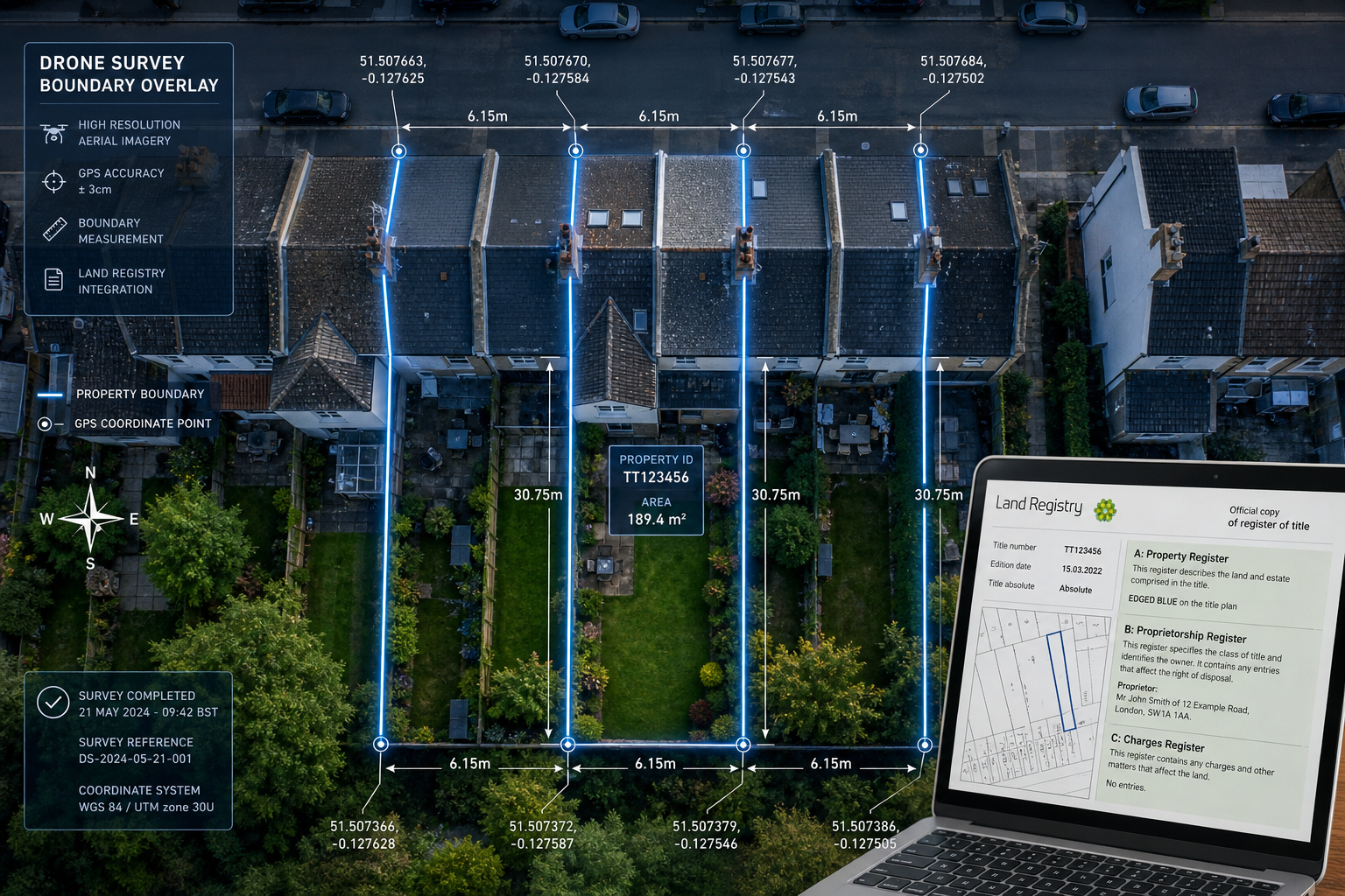
- Precise site measurement — Using GPS/GNSS equipment, total stations, or drone survey technology to capture accurate coordinates of all boundary features
- Data integration — Overlaying site measurements onto Land Registry title plan data within a GIS or CAD environment
- Discrepancy analysis — Identifying and quantifying any differences between physical features and registered boundaries
- Expert report preparation — Drafting a CPR Part 35-compliant report setting out findings, methodology, and conclusions
Technology Tools Transforming Boundary Evidence in 2026
The technical toolkit available to boundary surveyors has advanced considerably. In 2026, several technologies are now standard practice for high-quality expert witness work.
🛰️ GPS/GNSS Real-Time Kinematic (RTK) Surveying
RTK GPS equipment allows surveyors to measure boundary features to an accuracy of ±10–20mm under good conditions. This level of precision is far beyond what manual tape measurements or basic handheld GPS can achieve, and it provides a defensible, repeatable datum for court evidence.
🚁 Drone (UAV) Surveys
Drone surveys have become a powerful tool for boundary disputes involving larger plots, agricultural land, or complex topography. Aerial photogrammetry can produce orthomosaic images and 3D point clouds that allow precise measurement of boundary features from above — capturing evidence that would be difficult or impossible to gather at ground level.
📐 Total Station Instruments
Total stations combine electronic distance measurement with angular measurement to produce highly accurate survey data. They are particularly useful in urban environments where GPS signal may be obstructed by buildings.
🗺️ GIS and CAD Integration
Geographic Information System (GIS) software allows surveyors to overlay multiple data sources — Land Registry plans, OS MasterMap data, historical maps, and site measurements — in a single georeferenced environment. This makes discrepancies visually clear and mathematically quantifiable for court presentation.
Common Dispute Types Handled by Boundary Expert Witnesses
Boundary surveys in expert witness roles cover a wide range of dispute categories. Understanding which type of dispute is at hand helps determine the most appropriate methodology [3]:
- Boundary disputes — The most common type; disagreements over where a legal boundary sits between two properties
- Easement conflicts — Disputes over rights of way, drainage rights, or other access rights across land
- Encroachment claims — Where a structure, fence, or extension is alleged to cross onto a neighbour's land
- Title and deed issues — Conflicts arising from ambiguous or contradictory wording in historical title documents
- Property line litigation — Formal court proceedings requiring expert evidence on boundary positions [3]
For disputes involving shared structures, the complexity increases further. Issues around shared chimneys and chimney stacks or party wall matters often intersect with boundary questions, requiring surveyors to address multiple legal frameworks simultaneously.
CPR Part 35: The Legal Framework for Expert Evidence
In England and Wales, expert witness surveyors must comply with Civil Procedure Rules Part 35 when preparing reports for court. This framework sets out strict requirements that directly shape how boundary survey evidence must be presented.
Key CPR Part 35 Requirements
| Requirement | Detail |
|---|---|
| Duty to the court | The expert's overriding duty is to the court, not the instructing party |
| Independence | Reports must be objective and unbiased |
| Signed declaration | Experts must sign a statement confirming they understand their duty |
| Single joint expert | Courts may direct parties to instruct a single shared expert |
| Written questions | Opposing parties may submit written questions to the expert |
⚠️ Important: Surveyors who act as advocates for their instructing party — rather than as independent experts — risk having their evidence excluded entirely. Courts take the independence requirement seriously.
Pre-Litigation: The Value of Early Expert Engagement
One of the most important — and often overlooked — aspects of boundary dispute resolution is the value of engaging an expert before litigation begins. A well-prepared boundary survey report, produced by a local chartered surveyor with expert witness experience, can:
- Provide both parties with an objective view of the boundary position
- Form the basis of a mediated settlement without court involvement
- Satisfy the Pre-Action Protocol requirements that courts expect parties to have followed
- Significantly reduce legal costs for both sides
This pre-litigation function is where boundary surveys in expert witness roles: combining site measurements with Land Registry data for 2026 disputes delivers some of its greatest practical value.
Building a Defensible Expert Report: Best Practice for 2026
A boundary expert witness report that will withstand scrutiny in 2026 must meet both technical and legal standards. The following best practices reflect current guidance from professional bodies including the RICS and NSPS.
✅ Structure of a Strong Expert Witness Report
- Executive summary — Brief, clear statement of the expert's conclusions
- Instructions received — What the expert was asked to do and by whom
- Documents reviewed — Full list of all materials considered
- Site inspection details — Dates, conditions, equipment used, and methodology
- Findings — Detailed description of what was found on site and in the records
- Analysis — How site measurements compare with Land Registry data
- Conclusions — The expert's professional opinion on the boundary position
- Statement of truth — CPR Part 35 declaration signed by the expert
Handling Discrepancies Between Site and Registry Data
When physical measurements reveal a discrepancy with the Land Registry title plan — which is common — the expert must explain:
- The magnitude of the discrepancy (in metres or millimetres)
- The likely cause (e.g., OS mapping tolerance, historical fence movement, encroachment)
- The legal implications (which boundary position takes precedence and why)
This analysis is where specialist knowledge of both surveying and property law becomes essential. For complex structural or physical boundary features, a specific defect report may also be required to document the condition of walls, fences, or other boundary structures.
Working with Historical Evidence
Boundary disputes often turn on historical evidence — old photographs, aerial imagery, historical OS maps, and witness statements from long-term residents. Expert surveyors must be skilled at integrating this historical material with modern measurement data to build a chronological picture of how a boundary has — or has not — moved over time [4].
For properties where subsidence or ground movement may have affected boundary features, additional specialist investigation may be needed to distinguish between deliberate encroachment and natural ground movement.
Resolving Disputes: From Survey to Settlement
The ultimate goal of boundary surveys in expert witness roles is resolution — whether through negotiation, mediation, or court determination. Understanding the resolution pathway helps parties make informed decisions.
Resolution Options at a Glance
| Route | Typical Timeline | Cost Level | Expert Role |
|---|---|---|---|
| Negotiated settlement | Weeks to months | Low–Medium | Advisory |
| Mediation | 1–3 months | Medium | Neutral expert or joint instruction |
| Land Registry Adjudicator | 6–18 months | Medium–High | Expert witness report |
| County Court / High Court | 1–3+ years | High | Full expert witness |
The most cost-effective outcome is almost always a negotiated settlement supported by a clear, objective survey report. When both parties can see the same accurate data — site measurements overlaid on Land Registry plans — the factual basis for dispute often narrows considerably.
For disputes involving schedule of condition reports or where the physical state of boundary structures is contested, having a contemporaneous photographic and measurement record is invaluable.
Conclusion: Actionable Next Steps for 2026 Boundary Disputes
Boundary disputes are rarely simple — but they are far more manageable when approached with the right expertise and the right evidence. The combination of precise site measurements and Land Registry data, prepared by a qualified expert witness surveyor, gives all parties — and ultimately the court — the clearest possible picture of where a boundary truly lies.
Here are the key next steps for anyone facing a boundary dispute in 2026:
- Do not move or alter any boundary features before a survey is carried out — this can destroy critical evidence
- Gather all available documents — title deeds, old photographs, planning permissions, and any prior correspondence about the boundary
- Instruct a qualified chartered surveyor with specific expert witness experience as early as possible
- Consider a joint instruction with the neighbouring party — a single expert instructed by both sides carries greater weight and reduces cost
- Explore mediation before committing to litigation — a clear survey report often makes mediation far more productive
- Ensure any expert report is CPR Part 35 compliant if court proceedings are possible
The integration of modern survey technology with authoritative Land Registry data represents the gold standard for boundary dispute evidence in 2026. Engaging the right expert early — one with both the technical skills and the legal knowledge to navigate this process — is the single most effective step any party can take.
References
[1] Rules Of The Game The Surveyor As An Expert Witness – https://www.xyht.com/professional-surveyor-archives/rules-of-the-game-the-surveyor-as-an-expert-witness/
[2] Mapping And Surveying S 3 – https://www.jurispro.com/category/mapping-and-surveying-s-3
[3] Land Surveying – https://www.expertinstitute.com/expert-witness/land-surveying/
[4] Mapping Surveying Expert Witness Case Summary – https://www.expertwitnessblog.com/mapping-surveying-expert-witness-case-summary/
[8] Boundary Expert Witness – https://seakexperts.com/keywords/boundary-expert-witness