Property boundaries have sparked conflicts between neighbors for centuries, and in 2026, these disputes remain among the most contentious legal battles in real estate. When a fence encroaches six inches onto adjacent land or historical records contradict modern measurements, property owners turn to professional surveyors for answers. Boundary Dispute Resolution: Proven Field Techniques and Courtroom Strategies for Property Surveyors represents the critical intersection where precise field measurements meet legal proceedings, where adverse possession claims challenge established boundaries, and where expert testimony can determine property ownership worth thousands or even millions of dollars.
The stakes in boundary disputes extend far beyond simple property lines. Encroachments can cloud titles, prevent sales, and destroy neighborly relationships. Professional surveyors serve as both technical investigators and expert witnesses, employing advanced GNSS technology, historical record analysis, and forensic measurement techniques to establish definitive property boundaries. Their work provides the foundation for legal resolution, whether through negotiated settlements, mediation, or courtroom litigation.
Key Takeaways
- Field investigation techniques combining GNSS verification, historical deed research, and physical monument analysis establish legally defensible boundary determinations that withstand courtroom scrutiny
- Expert witness preparation requires surveyors to translate technical measurements into clear testimony, supported by comprehensive documentation and adherence to professional standards
- Preventative strategies including pre-purchase surveys and formal boundary agreements help property owners avoid costly disputes before they escalate to litigation
- Documentation standards must meet both surveying best practices and legal evidentiary requirements, creating detailed plats, reports, and chain of custody records
- Alternative resolution methods such as mediation and boundary line agreements often provide faster, more cost-effective outcomes than protracted court battles
Understanding Common Boundary Disputes and Their Legal Implications
Types of Boundary Conflicts
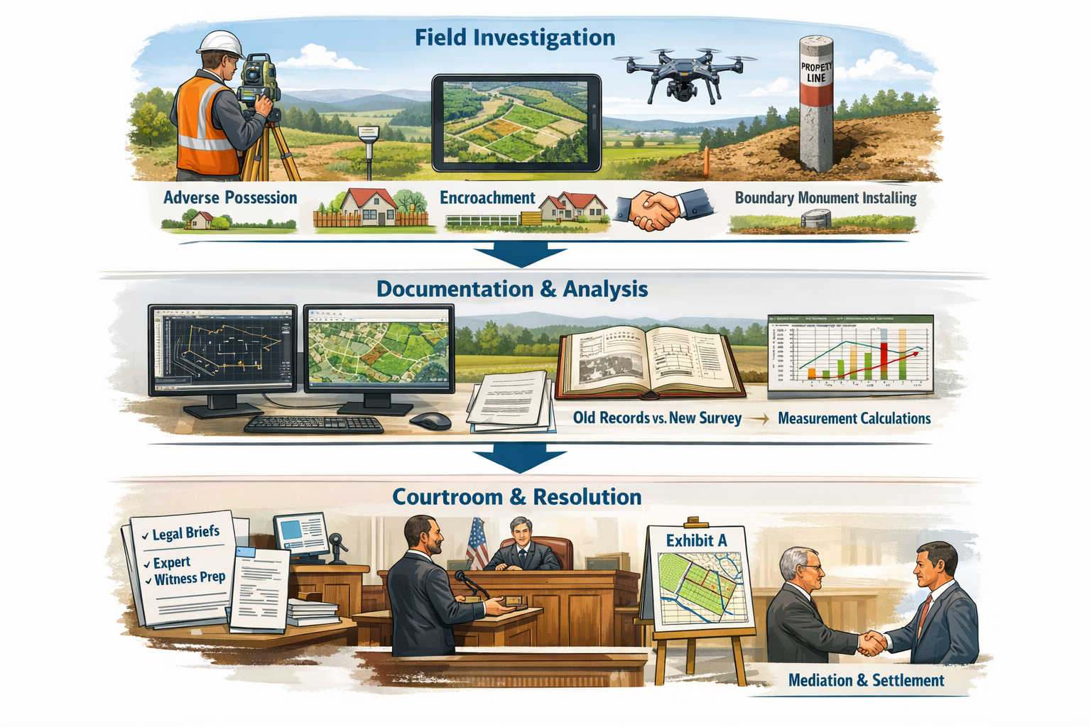
Boundary disputes manifest in several distinct forms, each requiring specific investigative approaches. Encroachment disputes occur when structures, fences, or landscaping features cross established property lines. A homeowner who builds a garage partially on neighboring land creates an encroachment that may lead to removal orders or adverse possession claims[2].
Adverse possession represents one of the most complex boundary challenges. When someone openly uses another's property for a statutory period (typically 7-20 years depending on jurisdiction), they may legally claim ownership of that portion. Surveyors must document the extent and duration of such use, examining historical aerial photographs and witness testimony[3].
Conflicting deed descriptions arise when historical property descriptions contain errors, ambiguities, or contradictions. A deed referencing "the old oak tree" as a boundary marker becomes problematic when that tree no longer exists. Surveyors must reconcile these discrepancies through careful analysis of the entire chain of title and surrounding property descriptions.
Legal Framework for Boundary Determination
Courts apply specific legal principles when evaluating boundary disputes. The hierarchy of evidence typically prioritizes:
- Original monuments (physical markers placed by previous surveyors)
- Natural monuments (rivers, rock formations, distinctive trees)
- Courses and distances (bearings and measurements in deeds)
- Area calculations (acreage descriptions, considered least reliable)
Understanding this hierarchy guides surveyors in their field investigations and expert testimony. A found original iron pin carries more legal weight than a deed measurement that conflicts with it[1].
Financial and Emotional Stakes
The costs of boundary disputes extend beyond legal fees. Property owners face:
- 📊 Reduced property values when title disputes cloud ownership
- ⚖️ Legal expenses ranging from $5,000 to $50,000 or more for litigation
- 🏗️ Construction delays when encroachments halt development projects
- 😤 Relationship damage between neighbors that persists for years
- 📉 Lost sale opportunities when buyers withdraw due to boundary uncertainties
Professional surveys conducted before disputes escalate typically cost $500-$3,000, representing significant savings compared to litigation expenses[5].
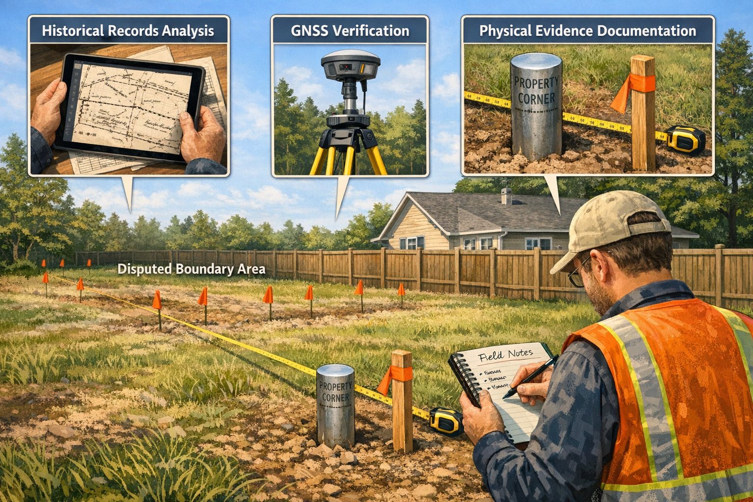
Field Investigation Techniques for Boundary Dispute Resolution
Historical Record Research and Chain of Title Analysis
Effective Boundary Dispute Resolution: Proven Field Techniques and Courtroom Strategies for Property Surveyors begins long before arriving on site. Comprehensive historical research establishes the documentary foundation for boundary determination.
Deed research involves tracing property ownership backward through successive transfers, examining each conveyance for boundary descriptions, exceptions, and reservations. Surveyors must identify:
- Original land grants or patents
- Subdivision plats and recorded maps
- Easements and rights-of-way
- Previous survey records
- Tax assessor maps and descriptions
Record discrepancies require careful analysis. When a 1950 deed describes a property as "100 feet along Main Street" but a 1975 survey shows 98.5 feet, the surveyor must determine which measurement controls. Historical context, measurement technology limitations, and the legal doctrine of senior rights all factor into this determination[2].
County recorder offices, historical societies, and even private collections may contain crucial evidence. One surveyor resolved a decades-long dispute by discovering an 1890s railroad survey map in a local museum that definitively established the original section corner location.
Modern GNSS and Total Station Measurements
Contemporary surveying technology provides unprecedented accuracy in boundary determination. GNSS (Global Navigation Satellite System) receivers achieve centimeter-level precision when properly calibrated and used with correction services.
Field measurement protocols for dispute resolution require:
- Multiple independent measurements of critical points
- Redundant observations using different equipment
- Documentation of atmospheric conditions affecting measurements
- Calibration records for all instruments
- Closure calculations proving mathematical consistency
Total stations combining electronic distance measurement with precise angle determination allow surveyors to establish coordinates for boundary monuments, building corners, and encroaching features. These measurements create the mathematical framework supporting boundary conclusions[1].
When GNSS measurements of a found iron pin conflict with deed descriptions by several feet, surveyors must investigate whether:
- The monument represents the actual boundary (trumping deed distances)
- Survey errors occurred in previous work
- The monument was disturbed or replaced incorrectly
- Deed descriptions contain transcription errors
Physical Evidence Documentation and Monument Analysis
Boundary monuments serve as critical physical evidence. Professional surveyors examine:
- Material composition (iron pipes, rebar, concrete monuments, wooden stakes)
- Condition and age (rust patterns, weathering, soil disturbance)
- Markings (surveyor stamps, dates, property identifiers)
- Surrounding evidence (witness trees, rock piles, fence remnants)
Proper documentation includes detailed photographs showing:
- Overall monument location and surroundings
- Close-up views of markings and condition
- Measurement tape showing depths if buried
- Reference measurements to permanent features
- Metadata recording date, time, and GPS coordinates
Forensic analysis of monuments can reveal crucial information. A rusted iron pipe driven 18 inches deep with 1960s-era surveyor markings carries more evidentiary weight than a fresh rebar stake with no identifiable markings. Soil disturbance patterns help determine whether monuments were recently placed or have remained undisturbed for decades[2].
Aerial Imagery and Historical Map Analysis
Aerial photographs spanning decades provide temporal evidence of property use, fence locations, and structural development. Comparing images from 1970, 1990, 2010, and 2026 reveals:
- When encroaching structures were built
- Historical fence line locations
- Vegetation patterns indicating property use
- Changes in property improvements over time
Geographic Information Systems (GIS) allow surveyors to overlay historical maps, aerial imagery, and modern survey data, identifying discrepancies and patterns. This technology proves particularly valuable when establishing adverse possession timelines or analyzing conflicting deed descriptions[4].
For property owners seeking professional assistance with choosing the right property survey for their specific situation, understanding these investigative techniques helps set realistic expectations for the survey process and timeline.
Preparing Legally Defensible Documentation
Survey Plat Requirements and Standards
A survey plat prepared for boundary dispute resolution must exceed standard requirements. Legally defensible plats include:
Essential elements:
- Title block with surveyor credentials and license number
- Property legal description matching deed records
- Scale and north arrow with declination
- Boundary measurements with precision statements
- Monument descriptions and conditions
- Adjoining property information
- Easements and encumbrances
- Surveyor's certification and seal
Dispute-specific additions:
- Encroachment locations with precise dimensions
- Conflicting evidence notation and resolution
- Historical monument references
- Measurement methodology explanation
- Accuracy statements and error analysis
- References to controlling documents
The plat serves as the primary visual evidence in legal proceedings. Clarity, accuracy, and professional presentation directly impact its persuasive value[1].
Written Reports and Technical Analysis
Comprehensive survey reports supplement plats with detailed explanations of methodology, findings, and conclusions. Effective reports follow a logical structure:
Introduction section:
- Assignment scope and purpose
- Property identification and location
- Client information and authorization
Research section:
- Documents examined and sources
- Historical survey analysis
- Deed description evaluation
- Chain of title summary
Field work section:
- Dates and conditions of fieldwork
- Equipment and methodology
- Monuments found and set
- Measurements and calculations
Analysis section:
- Evidence evaluation and weighting
- Conflicting information resolution
- Legal principles applied
- Professional judgment explanation
Conclusions section:
- Boundary determination and justification
- Encroachment descriptions
- Recommendations for resolution
Technical writing for legal purposes requires balancing precision with accessibility. Attorneys, judges, and juries must understand the surveyor's reasoning without extensive technical knowledge[2].
Chain of Custody and Evidence Management
When boundary disputes reach litigation, surveyors must demonstrate proper evidence handling. Chain of custody documentation tracks:
- Physical evidence collection (monument caps, survey markers)
- Photographic evidence with metadata
- Field notes and data files
- Processing and analysis records
- Storage and security measures
Digital evidence management presents unique challenges in 2026. GPS data files, drone imagery, and CAD drawings require:
- Secure backup systems with timestamps
- Version control preventing alterations
- Metadata preservation
- Export formats maintaining data integrity
- Access logs documenting who viewed or modified files
Courts increasingly scrutinize digital evidence authenticity. Surveyors must establish that electronic files presented at trial accurately represent original field data without manipulation[3].
Professional Standards Compliance
Boundary Dispute Resolution: Proven Field Techniques and Courtroom Strategies for Property Surveyors demands adherence to professional standards that provide legal credibility. Key standards include:
Minimum Technical Standards vary by jurisdiction but typically specify:
- Maximum allowable closure errors
- Monument setting requirements
- Research documentation minimums
- Plat content and format
- Professional certification requirements
Professional organization guidelines from groups like the National Society of Professional Surveyors provide best practice recommendations exceeding minimum legal requirements. Following these elevated standards strengthens expert testimony credibility.
Ethics codes govern surveyor conduct, prohibiting:
- Advocacy for one party over truth
- Accepting assignments beyond competence
- Misrepresenting qualifications or findings
- Inadequate research or fieldwork
Violations can result in license discipline and testimony exclusion. Maintaining ethical independence while serving client needs requires careful professional judgment[1].
Courtroom Strategies and Expert Witness Testimony
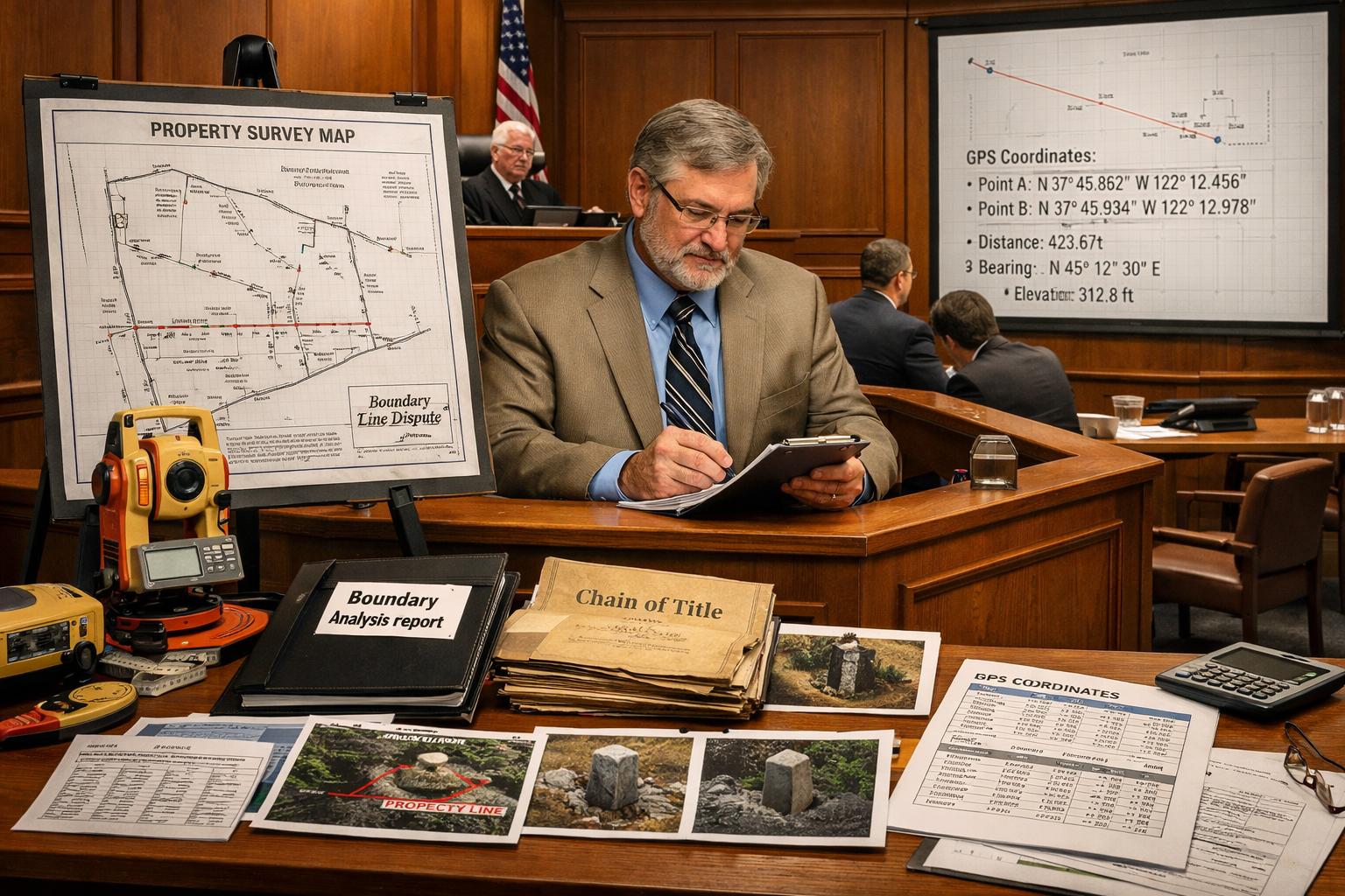
Preparing for Expert Witness Testimony
Transitioning from field surveyor to courtroom expert witness requires distinct skills. Effective preparation involves:
Case file mastery:
- Complete familiarity with all survey data
- Understanding of legal issues and claims
- Knowledge of opposing expert opinions
- Anticipation of challenging questions
- Review of deposition testimony for consistency
Visual aids development:
- Enlarged plats for courtroom display
- Photographic evidence boards
- Demonstrative exhibits showing methodology
- Comparative analysis charts
- Timeline graphics for adverse possession claims
Attorney coordination:
- Pre-trial meetings discussing testimony strategy
- Mock examination practice sessions
- Question and answer anticipation
- Exhibit review and organization
- Testimony scope and limitations discussion
Professional surveyors serving as expert witnesses must remember they serve the court's need for truth, not partisan advocacy. This independence enhances credibility with judges and juries[2].
Presenting Technical Evidence to Non-Technical Audiences
Courtroom communication differs fundamentally from technical reporting. Effective expert witnesses:
Simplify without oversimplifying:
- Use analogies relating to everyday experience
- Avoid unnecessary jargon and acronyms
- Define technical terms when first used
- Break complex concepts into logical steps
- Maintain technical accuracy while improving accessibility
Example testimony approach:
"Your Honor, determining a property boundary is similar to following a recipe. We start with the ingredients—the deed description, historical surveys, and physical monuments. We follow specific steps in a particular order, just as legal principles require us to prioritize certain types of evidence. The final result must be consistent with all the reliable ingredients we started with."
Visual communication:
- Point to specific features on enlarged plats
- Use laser pointers to highlight key elements
- Walk through measurement processes step-by-step
- Demonstrate equipment operation when relevant
- Connect abstract data to visible property features
Credibility markers:
- Professional demeanor and appropriate dress
- Confident but not arrogant delivery
- Admission of limitations when appropriate
- Respectful responses to challenging questions
- Clear distinction between facts and opinions
Judges and juries assess expert credibility based on both technical competence and communication effectiveness. The most accurate survey becomes worthless if the expert cannot explain it persuasively[1].
Handling Cross-Examination
Cross-examination tests expert witness preparation and credibility. Opposing attorneys employ various strategies:
Common attack approaches:
- Questioning qualifications and experience
- Highlighting fee arrangements suggesting bias
- Identifying minor errors or inconsistencies
- Presenting hypothetical scenarios
- Comparing to opposing expert opinions
- Challenging methodology or standards compliance
Effective response strategies:
Stay calm and composed:
- Pause before answering to consider questions
- Maintain professional demeanor regardless of attorney tactics
- Avoid defensive or argumentative responses
- Request clarification of unclear questions
- Take time to review documents before commenting
Answer only what's asked:
- Resist volunteering additional information
- Avoid speculation beyond expertise
- Distinguish between facts and assumptions
- Acknowledge limitations honestly
- Redirect to areas of certainty when appropriate
Maintain consistency:
- Reference previous testimony and reports
- Explain apparent contradictions when they arise
- Stand firm on well-founded conclusions
- Admit errors promptly if discovered
- Connect answers to documented evidence
One experienced surveyor notes: "The moment you become argumentative or defensive, you've lost credibility. Answer honestly, reference your documentation, and trust your preparation."
Expert Report Standards
Written expert reports submitted before trial must meet specific legal requirements while maintaining technical rigor:
Federal Rule of Civil Procedure 26 requirements (applicable in federal courts and adopted by many state courts) mandate:
- Complete statement of all opinions
- Basis and reasons for each opinion
- Data and information considered
- Exhibits supporting opinions
- Qualifications including publications and testimony history
- Compensation for study and testimony
Technical content standards:
- Clear statement of assignment and scope
- Comprehensive methodology description
- Complete data presentation and analysis
- Logical progression from evidence to conclusions
- Alternative hypotheses consideration and rejection
- Limitations and assumptions acknowledgment
Professional presentation:
- Organized structure with clear headings
- Professional formatting and graphics
- Proper citations and references
- Appendices with supporting documentation
- Executive summary for non-technical readers
Reports serve multiple purposes: educating attorneys, facilitating settlement negotiations, and providing trial testimony foundation. Quality reports often resolve disputes without trial by clearly establishing boundary facts[3].
Those interested in understanding the broader context of professional surveying services may find value in exploring commercial property surveyors who handle complex boundary issues in commercial real estate transactions.
Alternative Dispute Resolution Methods
Mediation and Negotiation Strategies
Mediation offers significant advantages over litigation for boundary disputes:
Benefits of mediation:
- ⚡ Faster resolution (weeks or months vs. years)
- 💰 Lower costs (typically 10-30% of litigation expenses)
- 🤝 Preserved relationships between neighbors
- 🎯 Creative solutions unavailable in court
- 🔒 Confidentiality protecting privacy
- ✅ Higher satisfaction rates with outcomes
Surveyor's role in mediation:
Professional surveyors facilitate resolution by:
- Presenting objective boundary evidence to both parties
- Explaining technical findings in accessible terms
- Identifying areas of agreement and disagreement
- Proposing practical solutions (easements, boundary adjustments)
- Drafting agreed-upon boundary descriptions
- Preparing documentation for formal recording
Effective negotiation approaches:
Interest-based negotiation focuses on underlying needs rather than positions. A property owner demanding fence removal may actually need:
- Assured access to their property
- Protection of future development rights
- Compensation for property value impact
- Formal recognition of correct boundary location
Addressing these interests often yields mutually acceptable solutions that strict legal enforcement cannot provide[1].
Boundary Line Agreements
Formal boundary line agreements resolve disputes through voluntary property line adjustments. These legal instruments:
Key components:
- Precise description of agreed boundary location
- Acknowledgment by all affected parties
- Consideration (exchange of value, even if nominal)
- Recording in county land records
- Survey plat showing new boundary
- Title company involvement ensuring clear title
Legal requirements vary by jurisdiction but typically include:
| Requirement | Purpose | Typical Standard |
|---|---|---|
| Writing | Statute of frauds compliance | Formal legal document |
| Signatures | Binding commitment | All owners + notarization |
| Recording | Public notice | County recorder filing |
| Survey | Precise location | Licensed surveyor plat |
| Consideration | Contract validity | Mutual exchange of rights |
Advantages over litigation:
- Parties control outcome rather than judge
- Immediate resolution without trial delays
- Reduced legal costs
- Customized solutions addressing specific needs
- Preserved neighbor relationships
Tax and title implications:
Boundary line agreements may trigger:
- Property tax reassessment based on new acreage
- Title insurance endorsements
- Mortgage lender approval requirements
- Zoning compliance verification
- Building setback recalculations
Professional legal and surveying advice ensures agreements comply with all applicable requirements[3].
Easement Solutions
Easements provide another resolution mechanism when property owners wish to maintain existing conditions despite technical encroachments:
Types of easements for boundary disputes:
Encroachment easements grant one owner the right to maintain structures crossing the boundary. A garage extending 18 inches onto neighboring property might be formalized through a perpetual easement, compensating the affected owner while avoiding demolition costs.
Access easements resolve disputes where property use requires crossing adjacent land. Driveways, utility lines, or pedestrian paths can be formalized with specific terms governing:
- Permitted uses and restrictions
- Maintenance responsibilities
- Duration (term or perpetual)
- Compensation or consideration
- Termination conditions
Prescriptive easements may be claimed through continuous use similar to adverse possession, but granting use rights rather than ownership. Surveyors document:
- Historical use patterns and duration
- Open and notorious nature of use
- Adverse character (without permission)
- Continuous and uninterrupted use
- Statutory period completion
Drafting effective easements:
Professional preparation ensures enforceability:
- Precise legal description of easement location
- Clear statement of rights granted and reserved
- Maintenance and cost allocation provisions
- Transferability to future owners
- Termination conditions if applicable
- Recording in public land records
Easements offer flexibility unavailable through strict boundary enforcement, often providing optimal outcomes for all parties[2].
Preventative Measures and Best Practices
Pre-Purchase Boundary Surveys
Preventative surveying represents the most cost-effective boundary dispute resolution strategy. Property buyers obtaining professional surveys before purchase avoid:
- Discovering encroachments after closing
- Title defects preventing resale
- Neighbor disputes inherited from previous owners
- Construction limitations from setback violations
- Easement surprises restricting property use
Comprehensive pre-purchase surveys identify:
✅ Exact boundary locations with monumentation
✅ Encroachments from or onto subject property
✅ Easements and rights-of-way affecting use
✅ Zoning compliance including setbacks
✅ Access verification to public roads
✅ Flood zone determinations
✅ Building locations relative to boundaries
The relatively modest cost of pre-purchase surveys (typically $500-$3,000) prevents disputes costing tens of thousands in legal fees[5]. Property buyers can negotiate purchase price adjustments or require sellers to resolve boundary issues before closing.
Understanding different types of survey comparison helps buyers select appropriate survey levels for their specific property and risk tolerance.
Proper Boundary Monumentation
Permanent boundary markers prevent future disputes by providing clear physical evidence of property lines:
Monument types and durability:
- Iron pipes or rebar (3/4" to 1" diameter, 18-24" length)
- Concrete monuments with surveyor identification
- Brass or aluminum caps marking specific points
- Wooden stakes (temporary, for construction layout)
- Rock mounds (historical, in rural areas)
Professional installation standards:
- Driven to refusal or specified depth
- Located at property corners and angle points
- Marked with surveyor license number
- Documented with precise coordinates
- Photographed for future reference
- Tied to permanent reference features
Maintenance and preservation:
Property owners should:
- Avoid disturbing monuments during landscaping
- Protect markers from construction equipment
- Verify monument locations before fence installation
- Photograph and document marker conditions periodically
- Report missing or damaged monuments to surveyors
Legal protection:
Many jurisdictions criminalize monument destruction or disturbance. Statutes typically impose:
- Misdemeanor or felony charges
- Fines ranging from $500 to $10,000
- Restitution for survey costs
- Civil liability for resulting damages
These protections recognize monuments' critical role in property rights preservation[1].
Neighbor Communication and Documentation
Proactive communication prevents many boundary disputes from escalating:
Best practices for property owners:
Before construction or improvements:
- Obtain professional survey confirming boundaries
- Share survey results with affected neighbors
- Discuss plans that might impact adjacent property
- Document agreements in writing
- Maintain respectful, cooperative relationships
When concerns arise:
- Address issues promptly before positions harden
- Seek objective professional surveys rather than arguing
- Consider mediation for disagreements
- Document all communications in writing
- Avoid accusatory or confrontational language
Formal documentation:
Written agreements should:
- Clearly describe the issue and resolution
- Include signatures of all parties
- Attach relevant survey plats or drawings
- Specify any compensation or considerations
- State recording intentions
- Preserve copies in property records
Fence agreements:
When neighbors install boundary fences, formal agreements should specify:
- Exact fence location relative to boundary
- Cost sharing arrangements
- Maintenance responsibilities
- Design and material standards
- Future modification procedures
- Acknowledgment of actual boundary location
Even when fences align with boundaries, written agreements prevent future owners from claiming adverse possession or boundary by acquiescence[3].
Technology Integration for Dispute Prevention
Modern technology offers powerful tools for preventing and resolving boundary disputes:
GIS and mapping systems:
- Online parcel viewers showing approximate boundaries
- Historical aerial imagery comparison
- Zoning and overlay district verification
- Easement and restriction research
- Tax assessment information access
Drone surveys provide cost-effective aerial documentation:
- Current property condition recording
- Encroachment identification
- Construction progress monitoring
- Vegetation and terrain mapping
- Orthophotography for measurement
Professional drone surveys complement traditional ground surveys, particularly for large properties or difficult terrain.
3D laser scanning:
- Precise building and structure documentation
- Encroachment measurement and analysis
- As-built condition recording
- Deformation monitoring over time
Digital record keeping:
- Centralized survey document storage
- Automated backup and version control
- Easy sharing with attorneys and experts
- Metadata preservation for evidence authentication
- Long-term accessibility and format migration
Mobile applications:
- Field data collection and photography
- GPS coordinate recording
- Sketch and note documentation
- Real-time data synchronization
- Offline functionality for remote locations
Technology enhances but does not replace professional judgment and expertise. Automated systems and consumer-grade GPS provide useful information but lack the accuracy and legal defensibility of professional surveys[4].
Regional Considerations and Jurisdictional Variations
State-Specific Legal Frameworks
Boundary law varies significantly across jurisdictions, affecting both field techniques and courtroom strategies:
Survey standards:
- Minimum technical standards differ by state
- Monument setting requirements vary
- Plat content and format specifications
- Professional licensing and continuing education
- Peer review and quality assurance mandates
Adverse possession requirements:
| Jurisdiction Type | Typical Period | Special Requirements |
|---|---|---|
| Standard | 10-20 years | Open, notorious, continuous, hostile |
| Color of title | 5-10 years | Deed or document claiming ownership |
| Tax payment | 5-7 years | Payment of property taxes required |
| Good faith | 10-15 years | Honest belief in ownership |
Boundary by acquiescence:
Some jurisdictions recognize boundaries established through long-term mutual recognition, even if technically incorrect. Requirements typically include:
- Extended period (often matching adverse possession)
- Mutual recognition by adjoining owners
- Physical boundary marker (fence, hedge, etc.)
- Continuous maintenance of recognized line
Professional surveyors must understand local legal frameworks when conducting boundary determinations and providing expert testimony[2].
Urban vs. Rural Boundary Challenges
Urban boundary disputes present distinct challenges:
Dense development:
- Small lot sizes magnifying minor discrepancies
- Multiple adjoining properties affected
- High property values increasing stakes
- Limited space for monument placement
- Extensive improvements complicating resolution
Record complexity:
- Numerous subdivisions and resubdivisions
- Condominium and townhouse arrangements
- Easement networks for utilities and access
- Historic district restrictions
- Zoning overlay complications
Rural boundary issues:
Large acreages:
- Extensive boundary lengths requiring investigation
- Remote access and difficult terrain
- Historical survey markers deteriorated or missing
- Natural monument changes (river courses, tree loss)
- Minimal improvement density reducing evidence
Agricultural considerations:
- Fence lines maintained for generations
- Cultivation patterns establishing use
- Water rights and riparian boundaries
- Mineral rights separations
- Grazing easements and agricultural leases
Surveyors must adapt methodologies to property characteristics while maintaining professional standards applicable to all boundary determinations[1].
For property owners in specific regions, consulting with chartered surveyors in Hertfordshire or other local professionals ensures familiarity with regional legal frameworks and common dispute patterns.
Historical Land Grant and Metes-and-Bounds Descriptions
Original land grants in many jurisdictions create unique boundary challenges:
Colonial grants:
- Descriptions referencing long-gone landmarks
- Measurements in chains, rods, and perches
- Magnetic bearings requiring declination adjustment
- Natural monuments as primary evidence
- Overlapping or conflicting grant boundaries
Metes-and-bounds descriptions:
Traditional descriptions following property perimeter:
- "Beginning at the large oak tree…"
- "Thence North 45 degrees East 10 chains…"
- "To the stone pile by the creek…"
- "Thence following the creek to the point of beginning"
Modern retracement challenges:
Surveyors must:
- Research historical surveying practices and equipment
- Understand period measurement standards and accuracy
- Locate or reconstruct original monuments
- Apply legal principles of senior rights
- Reconcile conflicts with modern coordinate systems
Public Land Survey System (PLSS):
Western United States properties often reference:
- Township and range designations
- Section, quarter-section, and smaller divisions
- Government survey monuments and corners
- Proportionate measurement principles
- Bureau of Land Management records
Each system requires specialized knowledge and research techniques. Professional surveyors often develop regional expertise in predominant local systems[6].
Case Studies and Practical Applications
Residential Encroachment Resolution
Case scenario: A homeowner in suburban London discovered their neighbor's garage extended 2.3 feet across the property line when obtaining a pre-sale survey. The garage had existed for 15 years, and the neighbor claimed ownership through adverse possession.
Field investigation:
- Historical deed research revealed original boundary description
- GNSS measurements located original iron pins at three corners
- Fourth corner monument missing, reconstructed through triangulation
- Garage foundation precisely measured relative to boundary
- Historical aerial photos confirmed garage construction date
Analysis and resolution:
- Surveyor's plat clearly showed 2.3-foot encroachment
- Legal research indicated 12-year adverse possession period in jurisdiction
- Neighbor's use met "open and notorious" requirement
- However, use was not "hostile" as original owner gave verbal permission
- Verbal permission negated adverse possession claim
Outcome:
- Mediation resulted in formal encroachment easement
- Neighbor paid £5,000 compensation for permanent easement
- Boundary line agreement recorded with county
- Both properties sold successfully with clear title
- Total resolution cost: £8,000 vs. estimated £40,000+ for litigation
This case demonstrates how professional surveys combined with mediation resolve disputes efficiently while preserving neighbor relationships[3].
Commercial Property Boundary Litigation
Case scenario: Two commercial property owners disputed a boundary affecting a planned expansion. The dispute involved conflicting surveys, missing monuments, and potential loss of millions in development value.
Expert witness preparation:
- Comprehensive research of 150+ years of property records
- Field investigation identifying original stone monuments
- GNSS network establishing precise control points
- Analysis of three previous surveys with conflicting conclusions
- Detailed written report explaining boundary determination
Courtroom testimony:
- Visual aids including 4-foot enlarged plats
- Demonstration of survey equipment and methodology
- Explanation of legal principles governing monument priority
- Cross-examination addressing opposing expert's methodology
- Rebuttal testimony clarifying measurement discrepancies
Key testimony exchange:
Attorney: "How can you be certain your boundary determination is correct when two previous surveyors reached different conclusions?"
Expert: "I located the original stone monuments placed in 1875, which both previous surveyors missed. Under the legal hierarchy of evidence, original monuments control over measurements. My determination aligns with these physical monuments and the original deed description. The previous surveys relied solely on measurements without adequate monument search."
Outcome:
- Court adopted surveyor's boundary determination
- Client retained valuable development area
- Opposing party appealed but settlement reached
- Expert's testimony cited as "thorough and credible"
- Case established precedent for similar disputes in jurisdiction
This case illustrates the critical importance of comprehensive research, precise fieldwork, and effective courtroom communication in Boundary Dispute Resolution: Proven Field Techniques and Courtroom Strategies for Property Surveyors[1].
Adverse Possession Defense
Case scenario: A property owner faced adverse possession claim from a neighbor who had maintained a garden on a disputed strip for 18 years, exceeding the 15-year statutory period.
Defense strategy:
- Survey documented exact area claimed (850 square feet)
- Historical research revealed original owner gave written permission in 2005
- Permission letter found in property records
- Subsequent owners unaware of permission arrangement
- Claimant's use was therefore "permissive" not "hostile"
Expert testimony focus:
- Precise boundary determination establishing encroachment extent
- Historical documentation authentication
- Explanation of "hostile use" legal requirement
- Analysis of property maintenance patterns
- Timeline reconstruction using aerial imagery
Outcome:
- Adverse possession claim defeated
- Property owner offered to sell disputed strip at fair market value
- Negotiated settlement: £15,000 payment for formal boundary adjustment
- Boundary line agreement recorded
- Both parties satisfied with resolution
This case demonstrates how thorough historical research and understanding of legal requirements can defeat seemingly strong adverse possession claims[2].
Conclusion: Mastering Boundary Dispute Resolution in 2026
Boundary Dispute Resolution: Proven Field Techniques and Courtroom Strategies for Property Surveyors represents a specialized discipline requiring technical excellence, legal knowledge, and communication skills. As property values continue rising and development intensifies in 2026, boundary disputes will remain a critical challenge for property owners and surveyors alike.
Professional surveyors serve as essential problem-solvers, combining historical research, advanced measurement technology, and forensic analysis to establish definitive property boundaries. Their work provides the foundation for legal resolution, whether through negotiated settlements, mediation, or courtroom litigation.
Key Success Factors
Technical competence remains fundamental:
- Mastery of GNSS, total station, and emerging technologies
- Understanding of legal principles governing boundary determination
- Comprehensive research skills accessing historical records
- Precise measurement techniques meeting professional standards
- Thorough documentation creating defensible evidence
Communication excellence separates adequate from exceptional expert witnesses:
- Translating technical findings for non-technical audiences
- Creating compelling visual aids and demonstrative exhibits
- Maintaining credibility under challenging cross-examination
- Writing clear, persuasive expert reports
- Coordinating effectively with legal teams
Preventative approaches offer the greatest value:
- Pre-purchase surveys identifying issues before closing
- Proper monumentation preventing future disputes
- Formal boundary agreements resolving ambiguities
- Neighbor communication maintaining relationships
- Technology integration improving accuracy and efficiency
Actionable Next Steps
For property owners:
- Obtain professional surveys before purchasing property or beginning improvements near boundaries
- Maintain boundary monuments and document their locations with photographs and measurements
- Communicate proactively with neighbors about boundary-related projects or concerns
- Formalize agreements in writing and record them in public land records
- Address issues promptly before positions harden and litigation becomes necessary
For professional surveyors:
- Invest in continuing education covering legal principles, new technologies, and expert witness skills
- Develop comprehensive research protocols ensuring no historical evidence is overlooked
- Maintain detailed documentation standards exceeding minimum legal requirements
- Build courtroom communication skills through training and practice testimony
- Establish relationships with experienced boundary dispute attorneys in your jurisdiction
- Join professional organizations providing resources, networking, and ethical guidance
For attorneys handling boundary disputes:
- Engage qualified surveyors early in dispute investigation and case development
- Understand surveying principles sufficiently to evaluate expert opinions critically
- Explore alternative resolution before committing to expensive litigation
- Prepare expert witnesses thoroughly for deposition and trial testimony
- Invest in quality visual aids making technical evidence accessible to judges and juries
The Future of Boundary Dispute Resolution
Emerging technologies continue transforming surveying practice. Artificial intelligence assists in historical document analysis, identifying patterns across thousands of pages of records. Blockchain technology may eventually provide immutable property boundary records. Augmented reality applications allow property owners to visualize boundaries overlaid on actual terrain through smartphone cameras.
However, technology enhances rather than replaces professional judgment. The fundamental challenges of Boundary Dispute Resolution: Proven Field Techniques and Courtroom Strategies for Property Surveyors—reconciling conflicting evidence, applying legal principles, and communicating findings persuasively—require human expertise that no algorithm can fully replicate.
As property ownership remains central to wealth building and personal security, boundary disputes will continue demanding skilled professionals who master both the science of precise measurement and the art of effective advocacy. Those surveyors who combine technical excellence with communication skills and ethical integrity will find growing opportunities to serve property owners, resolve conflicts, and contribute to the fair administration of property rights.
The investment in professional boundary surveys, proper documentation, and early dispute resolution consistently proves far more cost-effective than litigation. Whether you're a property owner protecting your investment, a surveyor building expertise, or an attorney representing clients, mastering these proven field techniques and courtroom strategies provides the foundation for successful boundary dispute resolution in 2026 and beyond.
For comprehensive surveying services including boundary determination and dispute resolution support, professional RICS home surveys and specific defect reports provide detailed property analysis supporting informed decision-making.
References
[1] Boundary Disputes How Professional Land Surveyors Resolve Conflicts – https://www.mcneilengineering.com/boundary-disputes-how-professional-land-surveyors-resolve-conflicts/
[2] Top Five Common Property Boundary Disputes And How Surveys Resolve Them – https://hmsurveying.com/top-five-common-property-boundary-disputes-and-how-surveys-resolve-them/
[3] Resolving Boundary Disputes A Guide For Property Owners – https://confidantconsult.com/resources/blog/resolving-boundary-disputes-a-guide-for-property-owners/
[4] Boundary Surveys – https://www.jouav.com/blog/boundary-surveys.html
[5] Blog Land Survey Costs 2026 – https://www.thelandgeek.com/blog-land-survey-costs-2026/
[6] Boundary Survey Guide – https://www.masterclass.com/articles/boundary-survey-guide