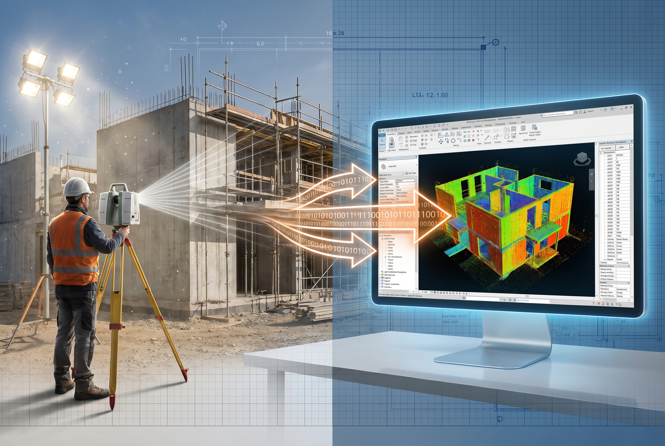
Construction rework costs the global industry an estimated $625 billion every year — much of it traceable to a single root cause: the gap between what was designed and what was actually built. Closing that gap is precisely where BIM and Surveying Synergy: Streamlining Building Information Modeling with Real-Time Field Data delivers its most powerful impact. When surveyors feed accurate, real-time measurements directly into Building Information Modeling (BIM) environments, teams can catch errors before they become expensive corrections, keep timelines on track, and hand over buildings that match their digital blueprints with millimetre-level confidence.
Key Takeaways
- Real-time field data from laser scanners, drones, and total stations dramatically reduces construction errors when integrated with BIM workflows.
- Augmented reality (AR) tools now allow field teams to overlay live BIM models onto physical sites with spatial precision as tight as plus or minus 2 cm.
- Integrated Scan-to-BIM pipelines compress the time between site capture and model update from days to minutes.
- BIM-GIS integration is expanding the reach of digital twins beyond individual buildings to entire urban environments.
- Surveyors are no longer just data collectors — they are active contributors to live digital twins that drive decision-making throughout the project lifecycle.
Why the Traditional BIM-to-Field Gap Costs Projects So Much
For years, BIM models lived primarily on office workstations. Design teams produced detailed 3D models, then handed over static PDFs or printed drawings to site crews. By the time a surveyor identified a discrepancy — a wall out of plumb, a duct clashing with a beam — the concrete had already been poured or the steelwork erected.
Research into BIM-to-field workflow failures identifies geospatial mismatches and lack of real-time integration as the two most common failure points [9]. A model built in one coordinate system, combined with site data captured in another, produces errors that compound at every stage. Add version-control problems — where field teams work from outdated model iterations — and the recipe for costly rework is complete.
The solution is not simply better software. It is a fundamental shift in how surveying data flows into and out of the BIM environment throughout the entire construction lifecycle, not just at the beginning and end.
Core Technologies Powering the BIM and Surveying Synergy
Laser Scanning and the Scan-to-BIM Pipeline
Terrestrial laser scanning (TLS) and mobile laser scanning have transformed how surveyors capture existing conditions. A single scan session can produce hundreds of millions of data points — a dense point cloud that captures every surface, angle, and dimension of a structure with sub-centimetre accuracy.
The Scan-to-BIM process converts those point clouds into intelligent BIM objects: walls, slabs, columns, MEP elements. Tools like the NavLive Radius Scanner take this further by using AI to generate real-time 2D and 3D models during capture, integrating directly with Autodesk Revit and AutoCAD [4]. What once took a surveying team days of post-processing can now be accomplished in minutes on site.
Key benefits of Scan-to-BIM workflows:
- Accurate as-built documentation for existing buildings and heritage structures
- Rapid detection of deviations from design intent during construction
- Reliable baseline data for renovation, extension, and refurbishment projects
- Reduced reliance on manual measurements, lowering human error
For property owners and buyers considering structural assessments, understanding how surveyors capture and model existing conditions is equally relevant. A residential structural survey uses many of the same principles of precise measurement and condition documentation that underpin professional BIM workflows.
Drones and Aerial Data Capture
Unmanned aerial vehicles (UAVs) add a vertical dimension to site surveying that ground-based instruments cannot easily replicate. Photogrammetry from drone flights generates dense point clouds and orthomosaic maps that update the BIM model with progress data across large sites.
Modern drone workflows can survey an entire construction floor plate in under an hour, comparing the resulting point cloud against the design model to flag deviations automatically. This is particularly valuable for monitoring surveys where tracking structural movement or construction progress over time is essential.
Total Stations and GNSS Integration
High-precision total stations remain the backbone of construction setting-out, but their role has evolved. Modern robotic total stations communicate directly with BIM software, allowing surveyors to stake out design coordinates from the model in real time and immediately log as-built positions back into the same environment.
Global Navigation Satellite System (GNSS) receivers add georeferencing accuracy, ensuring the BIM model sits correctly within real-world coordinate systems — a critical requirement for BIM-GIS integration. Research from Hong Kong University of Science and Technology highlights the growing importance of accurate georeferencing as BIM and GIS systems converge to support city-scale digital twins [8].
Augmented Reality: Bringing BIM and Surveying Synergy to the Field

Augmented reality is arguably the most transformative development in BIM-to-field workflows of the past decade. Rather than asking a site engineer to mentally translate a 2D drawing into three-dimensional reality, AR tools project the BIM model directly onto the physical environment through a tablet or headset.
Delta ARBIM overlays live Industry Foundation Classes (IFC) models onto construction sites, enabling real-time clash detection and as-built verification with spatial precision of plus or minus 2 cm [2]. A pipefitter can hold a tablet above a ceiling void and see exactly where a duct should run, compared with where it has actually been installed.
Sitelink provides a precise AR BIM viewer supporting indoor positioning and 3D capture, enhancing quality assurance and quality control (QA/QC) processes and improving coordination between trades [3]. When a clash is detected, the issue is logged directly in the model, creating a documented audit trail that benefits all stakeholders.
NEXT-BIM reports that its AR construction monitoring solution delivers up to 50% savings on rework costs by allowing teams to anticipate works, detect defects, and verify execution in real time [6]. That figure reflects the compounding value of catching errors at the point of installation rather than during snagging or handover.
"The most expensive defect is the one discovered after the work is complete. Real-time AR verification turns that equation around."
For surveyors involved in specialist defect surveys or structural surveys, the logic is identical: earlier detection always costs less than later remediation.
Collaborative Platforms: Keeping Every Team Member on the Same Model
Unified Data Environments
The value of real-time field data is only realised if every project contributor can access it simultaneously. Siloed data — where the surveyor's point cloud, the architect's Revit model, and the contractor's programme live in separate systems — recreates the same coordination failures that BIM was supposed to eliminate.
Trimble Quadri addresses this for infrastructure projects by enabling real-time collaboration in a central model, ensuring all contributors always work from the latest information [5]. Changes made by a surveyor in the field propagate instantly to the design team in the office and the project manager reviewing progress.
12d Synergy takes a similar approach specifically for surveying practices, providing a connected platform that unifies surveying, design, and BIM data with built-in version control and quality assurance [7]. A single, reliable source of project truth eliminates the version-control failures that account for a significant proportion of BIM-to-field breakdowns.
vSite combines AI, accurate as-built capture, and construction-grade AR to create a live digital twin that reflects exact installations for utility construction [1]. The platform's ability to maintain a continuously updated record of what has been installed — not just what was designed — is the essence of effective BIM and surveying synergy.
The Role of IFC and Open Standards
Interoperability between surveying instruments, point cloud software, and BIM authoring tools depends on open data standards. Industry Foundation Classes (IFC) provide a vendor-neutral format that allows data to move between platforms without loss of geometric or semantic information.
Surveyors who understand IFC workflows add significant value to BIM projects. They can deliver point clouds and as-built models in formats that design teams can immediately use, rather than requiring time-consuming conversion steps that introduce errors and delay decisions.
BIM-GIS Integration and the Future of Digital Twins

Building Information Modeling has traditionally focused on individual structures. Geographic Information Systems (GIS) operate at the scale of neighbourhoods, cities, and regions. Integrating the two creates digital twins that capture not just the building but its relationship to surrounding infrastructure, utilities, and environmental conditions.
Research into BIM-GIS integration highlights the growing need for robust methods of data analysis and mathematical modelling as these systems converge [8]. For surveyors, this convergence creates new service opportunities: providing georeferenced BIM data that feeds city-scale planning models, infrastructure management systems, and climate resilience assessments.
The emerging BIM2RDT framework takes this further still, proposing an agentic AI approach that transforms static BIM models into dynamic, robot-ready digital twins by integrating geometric and semantic BIM data with real-time site information [10]. Autonomous inspection robots and construction drones guided by live digital twins represent the near-term horizon for BIM-surveying integration.
For property professionals, the practical implications of this convergence are already visible. Commercial building surveys increasingly reference digital records and BIM data as part of condition assessments, while stock condition surveys for housing portfolios benefit from point cloud data that provides accurate floor areas, ceiling heights, and defect locations across hundreds of properties simultaneously.
Practical Workflow: From Site Capture to Updated BIM Model
The following table outlines a typical integrated BIM-surveying workflow in 2026, showing the tools, outputs, and time frames involved at each stage.
| Stage | Tool / Method | Output | Typical Time Frame |
|---|---|---|---|
| Initial site capture | Terrestrial laser scanner / drone | Dense point cloud | 2-8 hours on site |
| Point cloud processing | AI-assisted software (e.g., NavLive) | Registered, classified point cloud | Minutes to 2 hours |
| Model creation / update | Revit, ArchiCAD, or IFC-compliant BIM tool | Updated as-built BIM model | 1-4 hours |
| Field verification | AR overlay (Delta ARBIM, Sitelink) | Clash reports, deviation logs | Continuous / real-time |
| Collaboration sync | Trimble Quadri, 12d Synergy | Live shared model | Instant / cloud-based |
| Progress reporting | Drone photogrammetry comparison | Deviation heat maps | Weekly or as required |
This workflow compresses what was once a multi-week cycle of survey, process, model, review, and re-issue into a near-continuous loop. Design decisions that previously waited for the next monthly site meeting can now be made the same day.
What This Means for Surveyors and Property Professionals
The integration of real-time field data with BIM is not a threat to the surveying profession — it is an expansion of its scope and influence. Surveyors who develop competency in laser scanning, drone operation, AR tools, and BIM software become indispensable contributors to project teams rather than periodic data suppliers.
For clients commissioning surveys, the practical benefits are clear:
- Fewer surprises during construction because deviations are caught early
- More accurate as-built records for facilities management and future works
- Faster dispute resolution because discrepancies are documented in the model with timestamps and spatial coordinates
- Better-informed valuations because condition data is richer and more reliable
A RICS building survey conducted by a surveyor with BIM competency can deliver not just a written report but a georeferenced condition model that becomes a lasting asset for the property owner. Similarly, dilapidation surveys benefit from point cloud baselines that provide objective, measurable evidence of condition at a given point in time.
The subsidence surveys and damp surveys that form the core of residential surveying practice are also evolving. Thermal imaging, moisture mapping, and crack monitoring data can all be georeferenced and embedded in a property's BIM record, creating a longitudinal picture of building health that supports smarter maintenance decisions.
Conclusion
The convergence of surveying precision and BIM intelligence is reshaping how buildings are designed, constructed, and managed. BIM and Surveying Synergy: Streamlining Building Information Modeling with Real-Time Field Data is not a future aspiration — it is an operational reality for leading project teams in 2026, delivering measurable reductions in rework costs, programme overruns, and post-handover defects.
Actionable next steps for professionals and property owners:
- Audit current workflows to identify where the gap between design intent and as-built reality is widest — this is where integrated surveying tools will deliver the fastest return.
- Invest in interoperable technology — prioritise laser scanners, drone systems, and AR tools that export to IFC and integrate with major BIM authoring platforms.
- Engage BIM-competent surveyors early — the value of real-time field data is greatest when surveyors are involved from the pre-construction stage, not called in to document problems after they occur.
- Commission condition surveys that deliver digital outputs — ask for georeferenced point clouds and condition models alongside traditional written reports to build a lasting digital record of your property.
- Stay informed on BIM-GIS and AI developments — the pace of change in digital twin technology means that workflows adopted today will continue to evolve; maintaining awareness of emerging tools ensures competitive advantage.
For property owners and developers seeking expert surveying support that keeps pace with these advances, connecting with local chartered surveyors who understand both traditional survey practice and modern BIM workflows is the most direct path to better outcomes.
References
[1] Vsite – https://www.vgis.io/vsite/?utm_source=openai
[2] deltaarbim.tech – https://www.deltaarbim.tech/?utm_source=openai
[3] sitelink.ai – https://www.sitelink.ai/?utm_source=openai
[4] navlive.ai – https://navlive.ai/?utm_source=openai
[5] Quadri – https://construction.trimble.com/en/products/quadri?utm_source=openai
[6] Construction Monitoring – https://next-bim.com/en/service/construction-monitoring/?utm_source=openai
[7] Surveyors – https://12d.co/who-we-serve/surveyors/?utm_source=openai
[8] Trends And Opportunities Of Bim Gis Integration In The Architectu – https://researchportal.hkust.edu.hk/en/publications/trends-and-opportunities-of-bim-gis-integration-in-the-architectu/?utm_source=openai
[9] Why Bim To Field Workflows Fail How Integrated Data Fixes Bhoda 4qaje – https://www.linkedin.com/pulse/why-bim-to-field-workflows-fail-how-integrated-data-fixes-bhoda-4qaje?utm_source=openai
[10] arxiv – https://arxiv.org/abs/2509.20705?utm_source=openai