The construction industry stands at the threshold of a digital revolution. Picture a construction site where every beam, column, and surface is captured with millimetre-level accuracy in mere hours—a task that once required weeks of manual measurement. This transformation is happening right now, driven by the explosive growth of 3D laser scanning technology and its integration with Building Information Modeling (BIM). As urban projects become increasingly complex and error margins shrink, 3D Laser Scanning Mastery: Capturing Precise Digital Twins for Infrastructure and Construction Surveys has emerged as the cornerstone of modern construction excellence.
The construction lasers market is projected to expand from $2.93 billion in 2025 to $3.67 billion by 2030, with a compound annual growth rate (CAGR) of 4.5% from 2026 to 2030[5]. This remarkable growth reflects an industry-wide shift toward precision, data-driven processes, and digital twins that are fundamentally changing how infrastructure projects are planned, executed, and maintained.
Key Takeaways
✅ Precision Revolution: 3D laser scanning delivers millimetre-level accuracy, dramatically surpassing traditional surveying methods and reducing costly errors in infrastructure projects[1].
✅ Time Efficiency: Surveying tasks that previously required weeks can now be completed in days or hours, accelerating project timelines and reducing labour costs[1].
✅ BIM Integration: Federal mandates and ISO 19650 compliance requirements are driving widespread adoption of laser scanning for creating verified as-built models and digital twins[2][4].
✅ Market Growth: AI-enabled measurement systems, IoT-enabled laser devices, and rising demand for digital verification are fueling rapid market expansion through 2030[5].
✅ Safety Enhancement: Non-contact data acquisition eliminates the need to expose personnel to hazardous positions, making it ideal for complex infrastructure projects[1].
Understanding 3D Laser Scanning Technology and Its Infrastructure Applications
What Is 3D Laser Scanning?
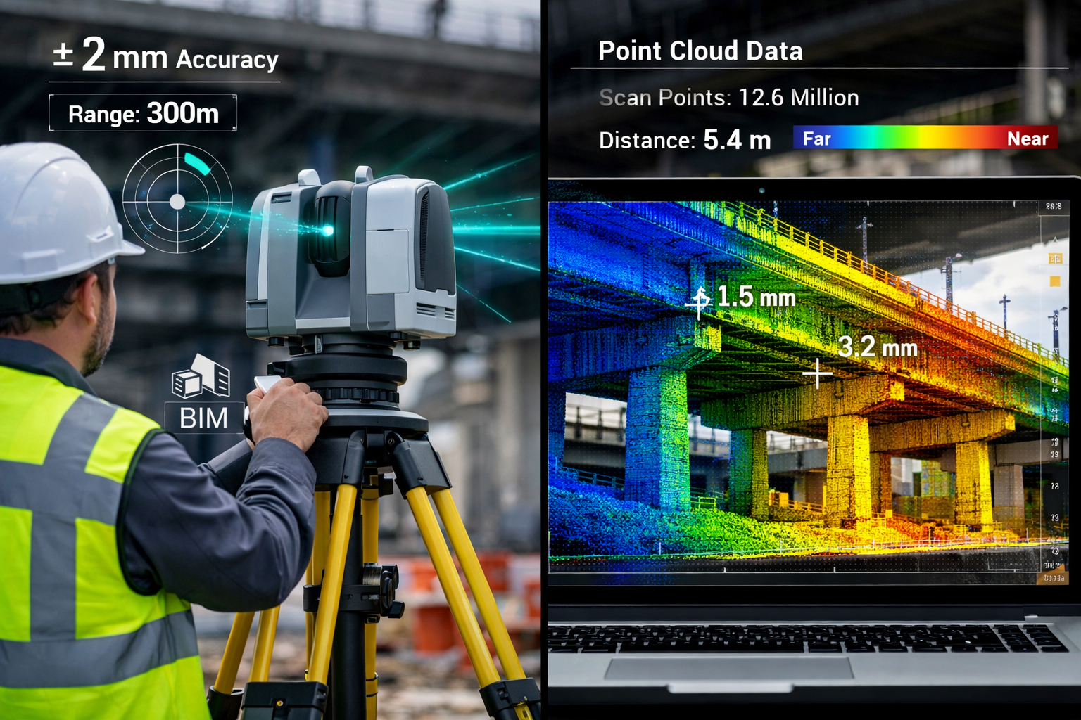
3D laser scanning is a non-contact, non-destructive technology that uses laser beams to rapidly capture the physical dimensions of objects, structures, and environments. The scanner emits millions of laser pulses per second, measuring the distance to surfaces by calculating the time it takes for each pulse to return. This process creates a point cloud—a dense collection of data points that accurately represents the scanned object in three-dimensional space.
Each point in the cloud contains precise X, Y, and Z coordinates, often accompanied by colour information captured through integrated cameras. Modern scanners can collect millions of points per second, creating highly detailed digital representations of complex structures ranging from bridges and tunnels to entire building façades.
The Technology Behind Point Cloud Generation
The core principle behind laser scanning involves LiDAR (Light Detection and Ranging) technology. When a laser scanner operates, it systematically rotates and tilts, directing laser pulses across a 360-degree field of view. The scanner's internal processor records:
- Distance measurements (range)
- Horizontal angles (azimuth)
- Vertical angles (elevation)
- Intensity values (reflectance)
- RGB colour data (from integrated cameras)
This comprehensive data collection enables the creation of digital twins—virtual replicas that mirror physical assets with exceptional fidelity. These digital twins serve as the foundation for structural surveys and advanced construction planning.
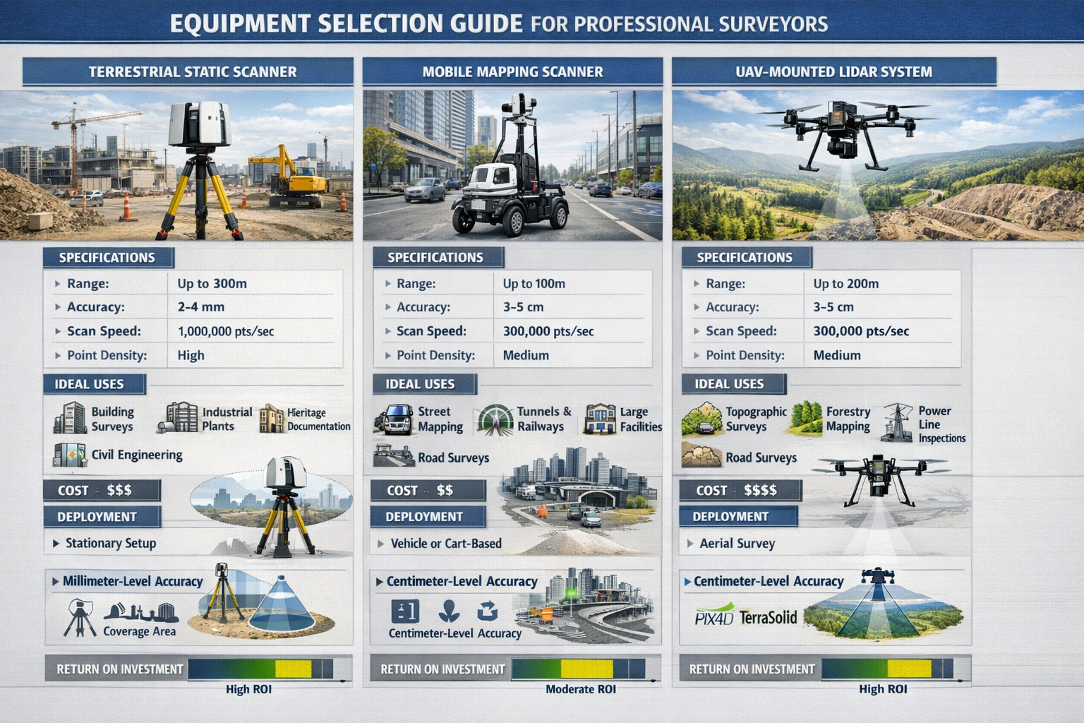
Types of 3D Laser Scanners for Construction
Professional surveyors have access to several scanner deployment methods, each suited to specific project requirements:
| Scanner Type | Range | Accuracy | Best Applications | Deployment Speed |
|---|---|---|---|---|
| Terrestrial Static | 0.5-350m | ±1-3mm | Buildings, bridges, industrial facilities | Moderate (requires multiple setups) |
| Mobile Mapping | 2-100m | ±5-20mm | Roads, railways, urban corridors | Fast (continuous scanning) |
| UAV-Mounted | 50-500m | ±20-50mm | Large infrastructure, inaccessible areas | Very fast (aerial coverage) |
| Handheld | 0.5-30m | ±5-15mm | Interior spaces, complex geometries | Fast (walk-through scanning) |
Scanners are increasingly deployed on tripods, mobile carts, ground robots, and UAVs for surveying façades, bridges, plants, and tunnels, enabling faster coverage, broader access, and reduced human exposure to danger[4].
The Role of Digital Twins in Modern Construction
A digital twin represents more than just a 3D model—it's a dynamic, data-rich virtual representation that evolves throughout a project's lifecycle. In 2026, the global construction market is experiencing a paradigm shift characterized by precision, data-driven processes, digital twins, and heightened demands for as-built construction verification[4].
Digital twins created through laser scanning provide:
🔹 As-built verification against design models
🔹 Clash detection before physical construction
🔹 Progress monitoring throughout project execution
🔹 Facility management data for long-term operations
🔹 Structural health monitoring baselines for infrastructure
The federal General Services Administration (GSA) recently mandated that all building projects they undertake use a BIM (building information model) derived from laser scanning[2], underscoring the technology's critical role in government infrastructure development.
3D Laser Scanning Mastery: BIM Integration and Error Reduction in Urban Projects
The BIM-Laser Scanning Synergy
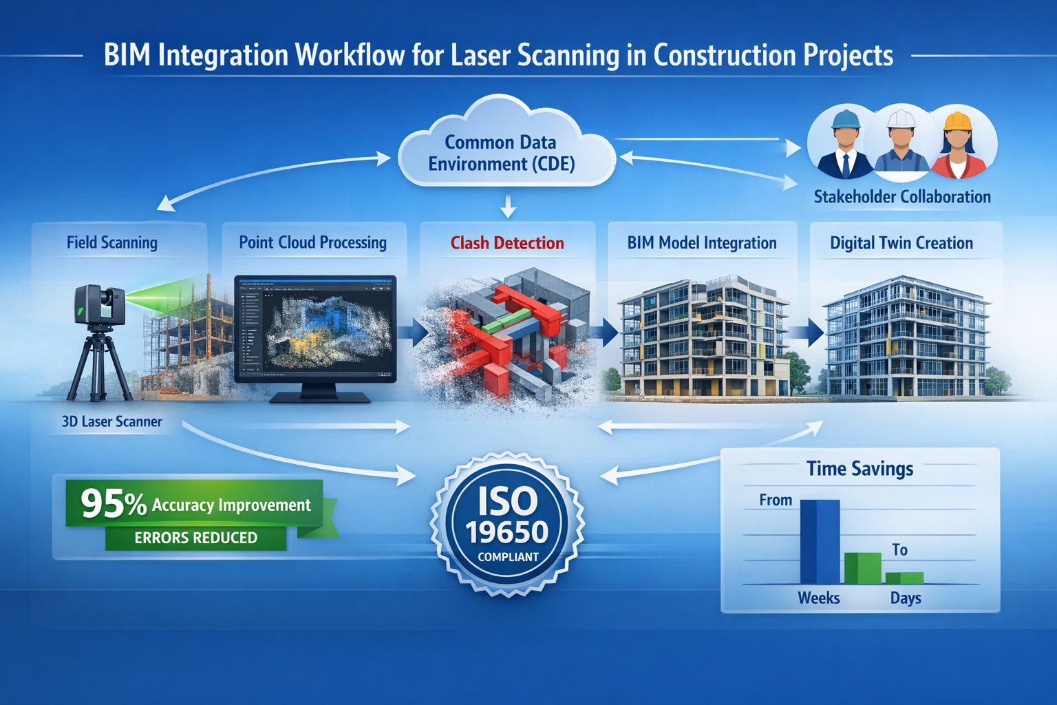
Building Information Modeling (BIM) and 3D laser scanning form a powerful partnership that's revolutionizing construction delivery. While BIM provides the design intent and planning framework, laser scanning supplies the precise as-built reality. This combination enables clash detection, quality control, and real-time project verification that were previously impossible with traditional methods.
Contractors are increasingly relying on common data environments (CDEs), 3D laser scanning, and advanced 3D modeling to enable real-time collaboration, reduce clashes, and mitigate on-site risk—becoming essential to maintaining control in fast-moving, high-stakes projects[3].
Workflow Integration: From Point Cloud to BIM
The integration process follows a systematic workflow that professional surveyors must master:
Step 1: Pre-Scan Planning
Identify critical areas requiring high-resolution capture, establish control points, and determine optimal scanner positions. This planning phase is crucial for different types of surveys and ensures comprehensive coverage.
Step 2: Field Data Collection
Deploy scanners according to the project plan, capturing overlapping scans to ensure complete coverage. Modern scanners can survey large areas within a few hours, compared to the weeks required by traditional methods[1].
Step 3: Point Cloud Registration
Align multiple scans into a unified coordinate system using common reference points or automated cloud-to-cloud registration algorithms. This creates a seamless digital representation of the entire site.
Step 4: Point Cloud Processing
Clean the raw data by removing noise, outliers, and unwanted objects. Segment the point cloud into meaningful components (walls, floors, structural elements) to facilitate modeling.
Step 5: BIM Model Creation
Extract geometric information from the point cloud to create accurate BIM objects. This can be done through manual modeling, semi-automated feature extraction, or AI-powered automated modeling.
Step 6: Quality Verification
Compare the BIM model against the original point cloud to verify accuracy. Generate deviation analysis reports showing where the model differs from reality.
Step 7: CDE Integration
Upload the verified model to the project's Common Data Environment, making it accessible to all stakeholders for coordination, clash detection, and construction planning.
Error Reduction Through Scan-to-BIM Workflows
Traditional surveying methods introduce multiple opportunities for human error—from misreading measurements to transcription mistakes. 3D laser scanning provides millimetre-level accuracy, significantly surpassing traditional total station or GPS surveying approaches[1].
The precision advantages translate directly into error reduction:
✅ Measurement accuracy: Eliminates manual measurement errors
✅ Data completeness: Captures every visible surface, preventing omissions
✅ Design verification: Identifies conflicts before construction begins
✅ As-built documentation: Provides indisputable record of existing conditions
✅ Change detection: Enables precise monitoring of structural movement
High-density point cloud data allows detection of millimetre-level movement, providing comprehensive insight into structural behaviour and complementing existing structural health monitoring (SHM) sensors like strain gauges and accelerometers[4]. This capability is particularly valuable for monitoring surveys of critical infrastructure.
Urban Project Applications and Case Studies
Urban infrastructure projects present unique challenges: limited access, ongoing operations, public safety concerns, and complex geometries. 3D Laser Scanning Mastery: Capturing Precise Digital Twins for Infrastructure and Construction Surveys addresses these challenges through versatile deployment options and rapid data collection.
Bridge Inspection and Rehabilitation
Laser scanning enables comprehensive documentation of bridge structures without disrupting traffic. Surveyors can capture detailed geometry of bridge decks, support structures, and clearances, identifying deformation, corrosion, and structural deficiencies. The precision is critical for infrastructure projects such as bridges where minor errors lead to substantial cost and time increases[1].
Tunnel Construction and Monitoring
Underground construction requires extreme precision for alignment, clearance verification, and convergence monitoring. 3D scanning provides continuous profiles along tunnel lengths, detecting deviations from design specifications and monitoring structural stability throughout excavation.
Historic Building Preservation
Urban renovation projects often involve historic structures requiring meticulous documentation. Laser scanning captures intricate architectural details, enabling accurate restoration planning while creating permanent digital archives of cultural heritage.
Utility Corridor Mapping
Dense urban environments contain complex networks of utilities—electrical, water, gas, telecommunications. Mobile laser scanning systems mounted on vehicles can rapidly map entire corridors, creating comprehensive as-built records that prevent costly utility strikes during construction.
ISO 19650 Compliance and Standards
Laser scanning has become a strategic requirement as BIM standards, data governance, and client expectations continue to evolve, with asset owners increasingly requiring verified as-built models, digital twins, and cloud-based CDEs delivered in compliance with ISO 19650[4].
ISO 19650 establishes international standards for managing information throughout the lifecycle of built assets using BIM. Compliance requires:
📋 Information requirements clearly defined at project outset
📋 Common data environments for centralized information management
📋 Standardized naming conventions and data structures
📋 Quality assurance processes for model verification
📋 Security protocols for information exchange
The National Institute of Standards and Technology (NIST) is working with industry and experts on volumetric and range performance testing of scanners, addressing the significant performance differences between different service providers' 3D models of the same facility[2].
Equipment Selection and Software Processing: A Professional Surveyor's Guide
Selecting the Right Scanner for Your Project
Choosing appropriate scanning equipment requires careful consideration of project-specific requirements. Professional surveyors must evaluate multiple factors to optimize data quality, efficiency, and cost-effectiveness.
Range Requirements
Determine the maximum distance between scanner positions and target surfaces. Indoor building surveys typically require short-range scanners (0.5-30m), while large infrastructure projects may need long-range scanners (up to 350m or more).
Accuracy Specifications
Match scanner accuracy to project tolerances. Precision manufacturing facilities may require ±1mm accuracy, while topographic surveys might accept ±20mm. Remember that scanner specifications represent optimal conditions—real-world accuracy depends on surface reflectivity, range, and environmental factors.
Scan Speed and Point Density
Balance data collection speed against required detail. Modern scanners can capture up to 2 million points per second, but higher speeds may reduce accuracy. Consider whether the project requires architectural detail (high density) or basic geometry (lower density acceptable).
Environmental Considerations
Evaluate operating conditions: temperature extremes, moisture, dust, vibration. Select scanners rated for the anticipated environment. Some scanners include IP (Ingress Protection) ratings indicating resistance to dust and water.
Portability and Deployment
Consider site access constraints. Confined spaces may require handheld or compact scanners, while open infrastructure projects can accommodate larger, more accurate terrestrial systems. Weight becomes critical for projects requiring frequent repositioning or difficult access.
Integration Capabilities
Ensure compatibility with existing workflows and software platforms. Look for scanners that export standard file formats (E57, LAS, LAZ, RCP) and integrate with your BIM software (Revit, ArchiCAD, Tekla, etc.).
Leading Scanner Manufacturers and Models (2026)
The market offers numerous options across different price points and capabilities:
Premium Terrestrial Scanners
- Leica RTC360 series: Ultra-fast scanning with automated field registration
- Faro Focus series: High accuracy with integrated HDR photography
- Trimble X12: Long-range capability with automated leveling
- Topcon GLS-2200: Robust design for harsh environments
Mobile Mapping Systems
- Leica Pegasus series: Vehicle-mounted for corridor mapping
- NavVis VLX: Indoor mobile mapping with simultaneous localization
- GeoSLAM ZEB series: Handheld SLAM technology for complex environments
UAV-Integrated LiDAR
- DJI Zenmuse L2: Lightweight airborne LiDAR for infrastructure
- YellowScan Surveyor Ultra: High-accuracy aerial scanning
- Phoenix LiDAR Scout series: Long-range aerial mapping
Software Processing Workflow
Raw point cloud data requires sophisticated processing to become useful construction information. Professional surveyors must master several software categories:
Point Cloud Registration and Processing
- Leica Cyclone: Industry-standard registration and modeling
- Faro Scene: Comprehensive processing for Faro scanners
- Trimble RealWorks: Advanced feature extraction and analysis
- Autodesk ReCap: Cloud-based processing and collaboration
These platforms handle essential tasks: scan registration, noise filtering, segmentation, and export preparation. Processing workflows typically follow this sequence:
- Import raw scans from scanner-specific formats
- Register scans using targets, cloud-to-cloud, or hybrid methods
- Clean data by removing outliers, vegetation, and temporary objects
- Segment point cloud into logical components
- Export processed data in formats compatible with modeling software
BIM Modeling from Point Clouds
- Autodesk Revit with point cloud plugins
- Graphisoft ArchiCAD with native point cloud support
- Tekla Structures for steel and concrete detailing
- Bentley MicroStation for infrastructure projects
Automated Feature Extraction
AI-powered tools are revolutionizing the modeling process. The market expansion is fueled by increasing adoption of AI-enabled measurement systems and IoT-enabled laser devices[5]. Software like ClearEdge3D, PointCab, and Gexcel Reconstructor automate extraction of walls, floors, pipes, and structural elements, reducing modeling time by 60-80%.
Quality Control and Analysis
- CloudCompare: Open-source comparison and analysis
- Polyworks Inspector: Precision dimensional analysis
- Geomagic Control X: Quality inspection and deviation reporting
Processing Best Practices for Optimal Results
Mastering software processing requires understanding both technical capabilities and practical workflows:
Optimize Registration Accuracy
Use a combination of target-based and cloud-to-cloud registration for maximum reliability. Place targets strategically to ensure visibility from multiple scan positions. Verify registration quality by checking overlap errors—aim for less than 3mm for high-precision projects.
Manage Data Volume Efficiently
Large infrastructure projects can generate hundreds of gigabytes of point cloud data. Implement data management strategies: use spatial indexing, create level-of-detail hierarchies, and archive raw data separately from processed deliverables.
Standardize Naming Conventions
Establish consistent naming for scans, targets, and exported files. Follow ISO 19650 guidelines for information management, ensuring all team members can locate and understand data assets.
Document Processing Parameters
Record all processing decisions: registration methods, filtering thresholds, segmentation criteria. This documentation ensures repeatability and supports quality assurance reviews, particularly important for building surveys requiring regulatory compliance.
Validate Against Control Points
Always verify processed point clouds against surveyed control points. Calculate residuals to ensure accuracy meets project specifications. This validation is critical for projects requiring schedule of condition reports or legal documentation.
Emerging Technologies Shaping the Future
The construction technology landscape continues evolving rapidly. Several trends are reshaping how professionals approach 3D Laser Scanning Mastery: Capturing Precise Digital Twins for Infrastructure and Construction Surveys:
AI-Powered Automated Modeling
Machine learning algorithms now recognize building components automatically, converting point clouds to BIM models with minimal human intervention. These systems learn from training data, improving accuracy as they process more projects.
Real-Time Scanning and Processing
Cloud computing enables real-time processing of scan data in the field. Surveyors can verify coverage completeness and data quality before leaving the site, eliminating costly return visits.
Integration with Augmented Reality
AR headsets overlay point cloud data onto physical environments, enabling on-site visualization of design intent versus as-built conditions. This technology supports quality control and construction sequencing.
IoT-Enabled Continuous Monitoring
Permanent scanner installations provide continuous structural monitoring, detecting movement, settlement, or deformation in real-time. This capability transforms infrastructure management from reactive to predictive maintenance.
Blockchain for Data Integrity
Emerging applications use blockchain technology to create immutable records of scan data, timestamps, and processing history, ensuring data authenticity for legal and regulatory purposes.
Advanced Applications: Structural Monitoring and Facility Management
Precision Structural Health Monitoring
Infrastructure assets require ongoing monitoring to ensure safety and longevity. Traditional structural health monitoring relies on discrete sensors—strain gauges, accelerometers, tiltmeters—that provide data at specific points. 3D laser scanning complements these systems by delivering comprehensive surface-level information across entire structures.
High-density point cloud data allows detection of millimetre-level movement, providing comprehensive insight into structural behaviour[4]. This capability enables:
Deformation Analysis
Periodic scanning creates temporal datasets showing how structures change over time. Comparing scans identifies settlement, deflection, or distortion that might indicate structural distress. This approach is particularly valuable for surveys for subsidence in buildings and infrastructure.
Crack Propagation Monitoring
High-resolution scans document crack width, length, and pattern. Sequential scans track crack growth, informing maintenance decisions and structural assessments. Automated change detection algorithms flag new cracks or significant growth.
Thermal Movement Documentation
Large structures expand and contract with temperature variations. Laser scanning captures these movements, helping engineers distinguish between normal thermal behaviour and concerning structural changes.
Load Testing Verification
During bridge load tests or proof loading, laser scanning documents structural response under known loads. This data validates design assumptions and structural capacity calculations.
As-Built Documentation and Facility Management
The value of laser scanning extends far beyond initial construction. Comprehensive as-built documentation supports facility management throughout a building's operational life.
Operations and Maintenance (O&M) Support
Accurate 3D models enable facility managers to plan maintenance activities, locate hidden infrastructure, and coordinate renovation work. Digital twins serve as the foundation for computerized maintenance management systems (CMMS).
Space Management and Optimization
Point cloud data provides verified floor areas, ceiling heights, and spatial relationships. Facility managers use this information for space planning, occupancy analysis, and lease management.
Renovation and Retrofit Planning
Before undertaking building modifications, designers need accurate existing conditions. Laser scanning eliminates the uncertainty of outdated drawings, reducing design errors and construction conflicts. This precision is essential for choosing the right property survey approach for renovation projects.
Emergency Response Planning
First responders benefit from accurate building models showing layouts, egress routes, and hazard locations. Digital twins support emergency planning and training exercises.
Energy Modeling and Sustainability
Accurate building geometry enables precise energy modeling for retrofit planning. Thermal imaging integrated with laser scanning identifies heat loss locations, supporting energy efficiency improvements.
Safety and Risk Mitigation
3D laser scanning enables surveying without exposing personnel to risky or physically inaccessible positions, making it the preferred tool for infrastructure projects involving heights, water bodies, or high hazard zones[1].
Hazardous Environment Documentation
Industrial facilities, chemical plants, and contaminated sites can be documented without prolonged human exposure. Scanners operate remotely or with minimal on-site time, reducing safety risks.
Post-Disaster Assessment
Following fires, earthquakes, or structural failures, laser scanning documents damage safely and comprehensively. The resulting data supports forensic investigation and reconstruction planning without requiring personnel to enter unstable structures.
Construction Site Safety Monitoring
Regular scanning identifies safety hazards: inadequate edge protection, unstable materials storage, or encroachment into safety zones. Automated comparison against safety plans flags violations.
Traffic Management and Public Safety
Implementation also minimizes disruption to ongoing construction activities in urban areas[1]. Mobile scanning systems capture roadway geometry while traveling at normal traffic speeds, eliminating lane closures and traffic disruption.
Overcoming Implementation Challenges
Cost Considerations and ROI Analysis
Professional-grade laser scanning equipment represents significant capital investment. Terrestrial scanners range from $25,000 to $150,000, while mobile mapping systems can exceed $500,000. However, the return on investment often justifies the expense.
Time Savings Quantified
Surveying tasks that previously required weeks using traditional methods can now be completed in a few days using 3D laser scanning[1]. For a typical bridge survey:
- Traditional methods: 15-20 days of field work
- Laser scanning: 2-3 days of field work
- Labour cost savings: 70-85%
Error Reduction Value
Construction errors cost the industry billions annually. A single clash detected during design prevents costly rework. Studies show BIM coordination supported by laser scanning reduces field conflicts by 60-90%, translating directly to cost savings.
Competitive Advantage
Firms offering laser scanning services command premium fees and win more projects. The technology demonstrates technical sophistication and commitment to quality, differentiating firms in competitive markets.
Training and Skill Development
Mastering 3D Laser Scanning Mastery: Capturing Precise Digital Twins for Infrastructure and Construction Surveys requires comprehensive training across multiple disciplines:
Field Data Collection Skills
- Scanner operation and calibration
- Scan planning and target placement
- Quality control in the field
- Safety protocols and site awareness
Software Processing Expertise
- Point cloud registration techniques
- Data cleaning and filtering
- Feature extraction and modeling
- Quality assurance workflows
BIM Integration Knowledge
- BIM software proficiency
- LOD (Level of Development) standards
- ISO 19650 information management
- Collaboration workflows
Professional organizations offer certification programs: ASPRS (American Society for Photogrammetry and Remote Sensing), RICS (Royal Institution of Chartered Surveyors), and manufacturer-specific training. Investment in staff development pays dividends through improved efficiency and reduced errors.
Data Management and Storage
Large-scale infrastructure projects generate enormous datasets. A comprehensive bridge scan might produce 500GB of raw data. Effective data management requires:
Storage Infrastructure
Implement redundant storage systems with backup protocols. Cloud storage offers scalability and accessibility but requires robust internet connectivity. Local network-attached storage (NAS) provides fast access for processing.
Data Lifecycle Management
Establish retention policies defining how long raw data, processed point clouds, and deliverables are maintained. Archive completed projects to free active storage while maintaining accessibility for future reference.
Security and Access Control
Implement appropriate security measures protecting sensitive infrastructure data. Use encryption for data transfer and storage. Establish role-based access controls ensuring only authorized personnel access project information.
Standards Development and Quality Assurance
NIST is working with industry and experts on volumetric and range performance testing of scanners. Standards development was initially projected to take 6 months to a year[2]. Until comprehensive standards emerge, firms must establish internal quality assurance protocols:
Scanner Calibration and Verification
Regular calibration ensures scanners maintain specified accuracy. Establish verification procedures using certified test ranges or calibration targets.
Process Documentation
Document all procedures: field data collection protocols, processing workflows, quality control checkpoints. This documentation supports consistency across projects and personnel.
Deliverable Standards
Define clear specifications for deliverables: point cloud density, accuracy requirements, file formats, coordinate systems. Align these standards with client requirements and industry best practices like those found in drone surveys and other advanced surveying methods.
Future Trends and Industry Evolution
Market Growth Trajectory
The construction lasers market demonstrates robust growth driven by technological advancement and increasing adoption. The market expansion is fueled by increasing adoption of AI-enabled measurement systems, IoT-enabled laser devices, and rising use of 3D scanning technology, alongside a broader shift from traditional to digital measurement tools[5].
Regional Growth Patterns
North America and Europe lead adoption, driven by mature construction markets and stringent quality requirements. Asia-Pacific shows the fastest growth rate, fueled by massive infrastructure investment in China, India, and Southeast Asia.
Sector-Specific Adoption
Transportation infrastructure (roads, railways, airports) represents the largest application segment. Building construction follows closely, with industrial facilities and energy infrastructure showing strong growth.
Regulatory Drivers and Mandates
Government mandates increasingly require digital documentation and BIM workflows. The federal General Services Administration (GSA) recently mandated that all building projects they undertake use a BIM (building information model) derived from laser scanning[2].
Similar requirements are emerging globally:
- UK government's BIM Level 2 mandate for public projects
- EU directives promoting digital construction documentation
- Infrastructure Investment and Jobs Act (US) emphasizing digital asset management
These mandates create sustained demand for laser scanning services and drive industry standardization.
Integration with Emerging Technologies
Digital Twin Ecosystems
Digital twins are evolving from static models to dynamic, data-rich platforms integrating real-time sensor data, maintenance records, and operational analytics. Laser scanning provides the geometric foundation for these comprehensive systems.
Artificial Intelligence and Machine Learning
AI algorithms automate increasingly complex tasks: object recognition, automated modeling, defect detection, and predictive maintenance. These capabilities reduce processing time and enable insights previously requiring extensive manual analysis.
5G and Edge Computing
High-bandwidth 5G networks enable real-time data transfer from scanning equipment to cloud processing platforms. Edge computing processes data locally, reducing latency and enabling immediate quality verification.
Autonomous Construction Equipment
Self-driving construction equipment uses laser scanning data for navigation and work execution. Automated grading, paving, and material placement rely on precise digital terrain models created through scanning.
Sustainability and Environmental Applications
Laser scanning supports sustainable construction practices through:
Material Quantity Optimization
Precise measurements reduce material waste by enabling accurate quantity takeoffs and minimizing over-ordering.
Existing Structure Reuse
Detailed documentation of existing buildings facilitates adaptive reuse rather than demolition, reducing embodied carbon and construction waste.
Energy Efficiency Analysis
Integration with thermal imaging identifies energy loss, supporting retrofit planning and building performance optimization.
Environmental Monitoring
Scanning documents environmental conditions, tracks erosion, and monitors vegetation, supporting environmental compliance and habitat protection.
Conclusion: Embracing the Digital Construction Future
The construction industry's transformation through 3D Laser Scanning Mastery: Capturing Precise Digital Twins for Infrastructure and Construction Surveys represents more than technological advancement—it signals a fundamental shift in how we conceive, build, and manage the built environment. With the market expanding to $3.67 billion by 2030[5] and regulatory mandates driving adoption, laser scanning has moved from specialized niche to essential capability.
Professional surveyors who master this technology position themselves at the forefront of construction innovation. The combination of millimetre-level accuracy, dramatic time savings, enhanced safety, and seamless BIM integration delivers compelling value across project lifecycles. From initial site documentation through construction verification to long-term facility management, laser scanning provides the data foundation for informed decision-making.
Actionable Next Steps for Professional Surveyors
Assess Your Current Capabilities
Evaluate your firm's existing equipment, software, and expertise. Identify gaps between current capabilities and market demands. Consider which project types offer the greatest opportunity for laser scanning application.
Develop an Implementation Roadmap
Create a phased approach to capability development:
- Phase 1: Acquire entry-level equipment and training
- Phase 2: Develop processing workflows and quality standards
- Phase 3: Expand service offerings and marketing
- Phase 4: Invest in advanced systems and specialization
Invest in Training and Certification
Commit to comprehensive staff development. Pursue manufacturer training, professional certifications, and continuous learning. The technology evolves rapidly—ongoing education ensures competitive advantage.
Establish Quality Management Systems
Develop documented procedures covering field data collection, processing workflows, and deliverable standards. Align these systems with ISO 19650 and industry best practices to meet client expectations and regulatory requirements.
Build Strategic Partnerships
Collaborate with software vendors, equipment manufacturers, and complementary service providers. These partnerships provide technical support, market intelligence, and business development opportunities.
Market Your Capabilities
Communicate your laser scanning expertise to existing and prospective clients. Develop case studies demonstrating value delivered. Position your firm as a technology leader committed to precision and innovation, similar to how firms showcase their expertise in structural engineering services.
Stay Informed on Industry Developments
Monitor emerging standards, regulatory changes, and technological advances. Participate in professional organizations and industry conferences. The construction technology landscape evolves rapidly—staying current ensures continued relevance.
The journey to 3D Laser Scanning Mastery: Capturing Precise Digital Twins for Infrastructure and Construction Surveys requires commitment, investment, and continuous learning. However, the rewards—enhanced accuracy, improved efficiency, competitive differentiation, and contribution to safer, more sustainable construction—make this journey essential for forward-thinking surveying professionals. As 2026 unfolds and the digital construction revolution accelerates, those who embrace these technologies will lead the industry into its data-driven future. 🏗️📊
References
[1] How 3d Laser Scanning Is Revolutionizing Infrastructure Projects – https://takhteetsurvey.com/how-3d-laser-scanning-is-revolutionizing-infrastructure-projects/
[2] New Standard For Mid Range 3d Laser Scanners On Horizon – https://www.geoweeknews.com/news/new-standard-for-mid-range-3d-laser-scanners-on-horizon
[3] Construction Technology Trends Shaping 2026 Innovations – https://modernconstructionnews.com/news/construction-technology-trends-shaping-2026-innovations/
[4] 7 Reasons To Use Lidar Construction Laser Scanning – https://blog.brightergraphics.com/7-reasons-to-use-lidar-construction-laser-scanning
[5] Trends Strategies Shaping The 3 67 Billion Construction Lasers Market 2026 2030 – https://www.globenewswire.com/news-release/2026/01/27/3226805/0/en/Trends-Strategies-Shaping-the-3-67-Billion-Construction-Lasers-Market-2026-2030.html