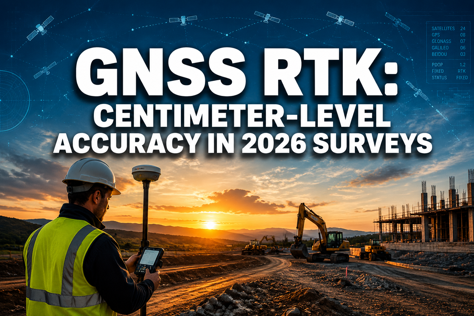
A single ransomware attack on a mid-sized UK surveying firm in early 2026 locked 14,000 georeferenced property records and halted completions on 37 active residential transactions — costing the practice an estimated £480,000 in recovery costs and lost fees before a single boundary line was redrawn. That incident is not an outlier. It is a signal.
As surveying practices migrate boundary records, LiDAR point clouds, and client-facing deliverables to cloud platforms, the attack surface for cybercriminals expands in direct proportion. Understanding cybersecurity essentials for property surveyors — protecting GIS data and cloud-based survey deliverables — is no longer a back-office IT concern. It is a core professional obligation, increasingly embedded in regulatory frameworks and client contracts alike.
This article examines the threat landscape surveyors face in 2026, the technical and procedural controls that reduce risk, and the compliance standards that now govern how digital survey data must be managed.
Key Takeaways
- Surveying firms handling GIS data and cloud-based deliverables face escalating ransomware, phishing, and insider-threat risks in 2026.
- Zero-trust security models, AES-256 encryption, and mandatory multi-factor authentication are the foundational technical controls every practice should implement.
- The RICS Global AI Standard (effective March 2026) introduces governance documentation requirements that directly affect how survey data and AI-assisted outputs are managed.
- Least-privilege access controls and regular penetration testing significantly reduce the blast radius of any successful breach.
- Compliance is not optional — regulatory penalties and reputational damage from a data breach can exceed the cost of implementing robust security from the outset.
The Expanding Threat Landscape for Surveying Practices

Property surveying has undergone a quiet digital revolution. Drone-captured point clouds, AI-driven feature extraction, automated parcel research, and interactive 3D digital twins have replaced paper-based workflows at a pace that has outrun many firms' security posture. Platforms that automate research processes — retrieving parcel data, GIS layers, and recorded documents — generate enormous volumes of sensitive geospatial information that must be stored, transmitted, and shared securely [7].
The data held by a typical surveying practice is attractive to attackers for several reasons:
- Property boundary records carry legal and financial weight. Manipulated or leaked boundary data can enable fraud in conveyancing transactions.
- Client personal data attached to survey instructions falls under UK GDPR and the Data Protection Act 2018, creating regulatory exposure.
- Commercial site data — including pre-planning surveys for large developments — carries significant competitive intelligence value.
- Infrastructure asset records, such as geo-referenced orthomosaic maps and 3D mesh models integrated into asset inventory geodatabases, represent critical operational data for local authorities and utilities [8].
Common Attack Vectors in 2026
The threat landscape has matured. Opportunistic attacks have given way to targeted campaigns against professional services firms. The most prevalent vectors affecting surveying practices include:
| Attack Type | How It Targets Surveyors | Potential Impact |
|---|---|---|
| Phishing and spear-phishing | Fake client emails requesting survey files | Credential theft, data exfiltration |
| Ransomware | Encrypts GIS databases and cloud-synced files | Operational shutdown, ransom demand |
| Supply chain compromise | Attacks via third-party software vendors | Backdoor access to client data |
| Insider threats | Disgruntled staff or contractors | Deliberate data leakage or deletion |
| Unsecured API endpoints | Exposed GIS platform integrations | Unauthorised bulk data download |
Firms offering drone survey services face a particular challenge: the data pipelines between UAV capture hardware, processing platforms, and cloud delivery portals create multiple potential interception points if not properly secured.
Core Cybersecurity Essentials for Property Surveyors: Protecting GIS Data and Cloud-Based Survey Deliverables
Implementing robust protection does not require enterprise-level IT budgets. It requires disciplined application of proven controls, applied consistently across every system that touches survey data.
Zero-Trust Architecture
The foundational shift in 2026 security thinking is the adoption of zero-trust models, which operate on the principle of "never trust, always verify." Every access request — whether from a field surveyor logging in remotely or an automated process pulling data from a GIS server — is authenticated and authorised independently, regardless of where it originates [1].
For surveying practices, zero-trust translates into practical steps:
- Require device health checks before granting access to cloud survey platforms.
- Segment networks so that GIS servers, client portals, and administrative systems cannot communicate freely with one another.
- Log every access event and review anomalies regularly.
"Zero-trust is not a product you buy — it is a posture you adopt. Every connection is treated as potentially hostile until proven otherwise."
Multi-Factor Authentication
Enforcing multi-factor authentication (MFA) across all systems is among the highest-return security investments a surveying firm can make. By requiring a second verification factor — such as a time-based one-time password (TOTP) or a hardware security key — MFA eliminates the majority of credential-based attacks even when passwords are compromised [1].
MFA should be mandatory for:
- Cloud storage platforms holding point cloud data and survey deliverables
- GIS software with remote access capability
- Email accounts used to send and receive survey instructions
- Client-facing portals where reports are downloaded
Encryption: AES-256 and TLS 1.3
Sensitive GIS data must be protected both when stored and when moving between systems. The current standard is AES-256 encryption for data at rest and TLS 1.3 for data in transit [1]. These are not optional enhancements — they are baseline requirements for any practice handling regulated personal or commercially sensitive data.
Firms providing boundary survey services should confirm that every platform used to store or transmit boundary records meets these encryption standards, and request written confirmation from cloud vendors as part of supplier due diligence.
Least-Privilege Access Controls
The principle of least privilege holds that every user account should have access only to the data and functions required for their specific role [1]. A junior field surveyor does not need write access to a master GIS database. An accounts administrator does not need access to client survey files.
Implementing least-privilege access involves:
- Conducting a role-by-role audit of current access permissions.
- Removing permissions that are not actively required.
- Using role-based access control (RBAC) features available in most enterprise GIS platforms.
- Reviewing and updating permissions whenever staff roles change.
This control is especially important for practices that engage subcontractors or specialist consultants — such as those conducting structural surveys or subsidence investigations — who may need temporary access to specific project files.
Secure Sharing of Cloud-Based Survey Deliverables
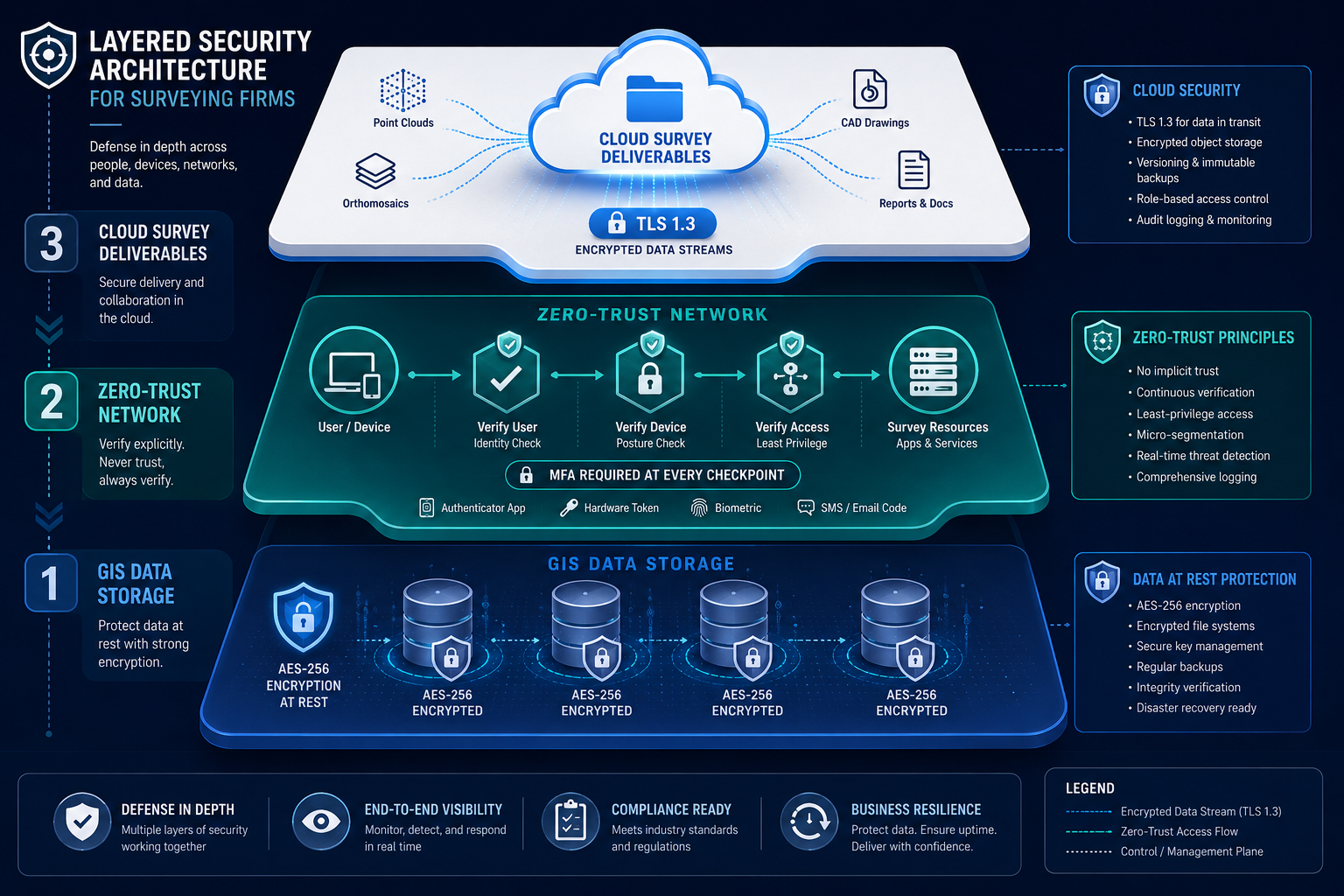
The delivery of survey outputs has shifted decisively toward cloud-based portals, interactive 3D viewers, and automated report generation. Companies now offer high-resolution aerial and ground capture services delivering interactive 2D and 3D views, inspection imagery, digital twins, and point clouds — all accessible to clients through web-based platforms [6]. This convenience creates security obligations that many practices have not yet fully addressed.
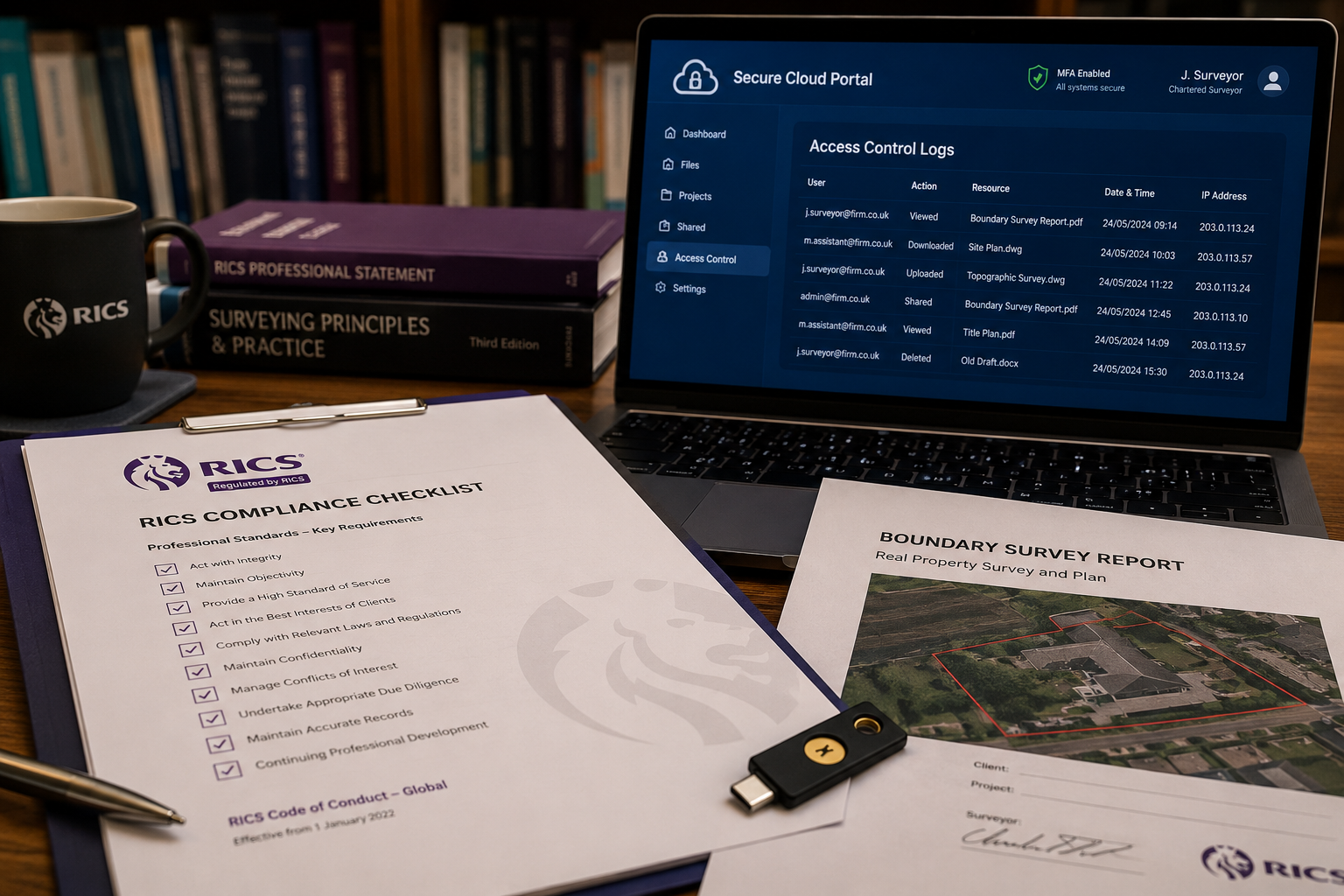
Secure Client Portal Configuration
When sharing deliverables through cloud portals, the following configurations should be treated as non-negotiable:
- Expiring links: Client download links should expire after a defined period, typically 7 to 30 days, rather than remaining permanently accessible.
- Watermarking: Embed client-specific watermarks in PDF reports and image exports to deter unauthorised redistribution and enable source tracing if a leak occurs.
- Access logging: Maintain records of who accessed which deliverable and when. This supports both security monitoring and professional indemnity claims if data misuse is alleged.
- Revocation capability: Ensure the platform allows instant revocation of access if a client relationship ends or a data incident is suspected.
Third-Party Vendor Risk Management
AI-powered platforms that transform point cloud data into 2D and 3D CAD linework, identifying over 50 feature types [3], and services providing rapid 24-48 hour turnaround for terrain models [5] are now embedded in many surveying workflows. Each vendor represents a potential security dependency.
Before integrating any third-party platform, practices should:
- Review the vendor's SOC 2 Type II report or equivalent security attestation.
- Confirm data residency — where is the data physically stored, and does that jurisdiction's law align with UK GDPR obligations?
- Establish contractual data processing agreements that specify retention periods and deletion obligations.
- Assess what happens to uploaded survey data after processing is complete.
LiDAR and photogrammetry-based deliverables, including colorized point clouds and digital orthophoto maps [4], often contain precise coordinate data that could be misused if a vendor's systems were compromised. Due diligence is not bureaucratic box-ticking — it is risk management.
Regulatory Compliance: RICS Standards and Data Governance in 2026
Regulatory requirements have tightened considerably in 2026, and cybersecurity essentials for property surveyors — protecting GIS data and cloud-based survey deliverables — now intersect directly with professional standards.
RICS Global AI Standard
Effective March 2026, the Royal Institution of Chartered Surveyors introduced a global AI standard requiring member firms to maintain governance documentation covering data provenance, model risk, and incident reporting [2]. For practices using AI-assisted valuation tools, automated feature extraction, or machine-learning-based report generation, this standard creates specific obligations:
- Document which AI tools are used, what data they process, and how outputs are validated.
- Maintain an incident log covering any AI-related errors, data anomalies, or security events.
- Ensure clients are informed when AI tools contribute materially to a survey output.
Non-compliance may result in disciplinary action by RICS and significant reputational damage [2]. Practices offering RICS home surveys or RICS commercial building surveys should review their current AI tool usage against the new standard immediately.
ALTA/NSPS Standards Update
For practices operating in or with US-based clients, the American Land Title Association and the National Society of Professional Surveyors revised their Minimum Standard Detail Requirements as of February 23, 2026 [2]. The updates emphasise enhanced precision, transparency, and uniformity in managing and documenting digital data — with direct implications for how GIS outputs are formatted, stored, and disclosed.
UK GDPR and Professional Indemnity Alignment
Beyond sector-specific standards, UK GDPR requires that personal data embedded in survey records — client names, property addresses, financial information — is processed lawfully, stored securely, and deleted when no longer required. A data breach affecting survey records triggers mandatory reporting to the Information Commissioner's Office (ICO) within 72 hours if it poses a risk to individuals.
Professional indemnity insurers are increasingly scrutinising cyber hygiene as part of renewal assessments. Practices that cannot demonstrate basic controls — MFA, encryption, access logging — may face higher premiums or coverage exclusions.
Building a Cyber-Resilient Surveying Practice: Practical Steps
Translating security principles into operational reality requires a structured approach. The following framework provides a practical starting point for practices of any size.
Conduct a Data Asset Inventory
Before protecting data, a practice must know what data it holds, where it lives, and who can access it. This inventory should cover:
- GIS databases and project files
- Cloud storage accounts and sync folders
- Email archives containing survey instructions and client data
- Third-party platform accounts holding processed deliverables
Implement Regular Penetration Testing
Annual penetration testing — engaging an accredited third party to attempt to breach systems — identifies vulnerabilities before attackers do. For practices handling high-value commercial survey data or commercial property valuations, this investment is proportionate to the risk.
Train Staff Continuously
The majority of successful cyberattacks begin with human error. Phishing simulation exercises, regular security awareness training, and clear incident reporting procedures reduce the likelihood that a staff member will inadvertently open a malicious attachment or click a fraudulent link.
Training should cover:
- Recognising phishing emails targeting surveying professionals
- Safe handling of client data on mobile devices in the field
- Procedures for reporting suspected incidents without delay
Develop and Test an Incident Response Plan
Every practice should have a documented plan that specifies what to do in the first hours following a suspected breach. The plan should name a response lead, identify external contacts (legal counsel, cyber insurer, ICO), and outline communication protocols for clients whose data may be affected.
Testing the plan through a tabletop exercise annually ensures it remains current and that staff know their roles.
Backup and Recovery
Ransomware attacks are most devastating when backups are inadequate or themselves encrypted. The 3-2-1 backup rule remains the standard: three copies of data, on two different media types, with one copy stored offline or in an air-gapped environment. Recovery times should be tested, not assumed.
Practices offering schedule of condition reports or stock condition surveys often hold extensive photographic and measurement archives — these must be included in backup and recovery planning.
Conclusion
The digitisation of property surveying has created extraordinary capabilities — faster turnaround, richer deliverables, and deeper analytical insight. It has also created obligations that the profession is still catching up with. Cybersecurity essentials for property surveyors — protecting GIS data and cloud-based survey deliverables — must be treated as a professional standard, not an afterthought.
The actionable steps are clear:
- Adopt zero-trust principles and enforce MFA across every system that touches survey data.
- Encrypt data at rest and in transit using AES-256 and TLS 1.3 as baseline standards.
- Apply least-privilege access controls and audit permissions regularly, especially for subcontractors and temporary staff.
- Conduct vendor due diligence before integrating any third-party AI, LiDAR processing, or cloud delivery platform.
- Align with RICS AI governance requirements and document AI tool usage, model risk, and incident reporting as required by the March 2026 standard.
- Test incident response plans annually and maintain offline backups of all critical GIS and survey data.
The cost of prevention is a fraction of the cost of recovery. More importantly, the trust that clients place in a surveying practice — trust that their property data, financial information, and project plans are handled with the same rigour applied to the survey itself — is not easily rebuilt once a breach has occurred.
References
[1] Cybersecurity Essentials For Property Surveyors Protecting Gis And Cloud Based Data In 2026 – https://kingstonsurveyors.com/cybersecurity-essentials-for-property-surveyors-protecting-gis-and-cloud-based-data-in-2026/?utm_source=openai
[2] Cybersecurity Essentials For Property Surveyors Protecting Digital Survey Data In 2026 – https://wimbledonsurveyors.com/cybersecurity-essentials-for-property-surveyors-protecting-digital-survey-data-in-2026/?utm_source=openai
[3] Planimetrics – https://www.rockrobotic.com/services/planimetrics/?utm_source=openai
[4] Lidar – https://www.topomatters.com/lidar/?utm_source=openai
[5] Surveyor – https://www.rockrobotic.com/services/surveyor/?utm_source=openai
[6] covegeo – https://www.covegeo.com/?utm_source=openai
[7] surveystack.app – https://www.surveystack.app/?utm_source=openai
[8] Services – https://iihub.com/services.html?utm_source=openai