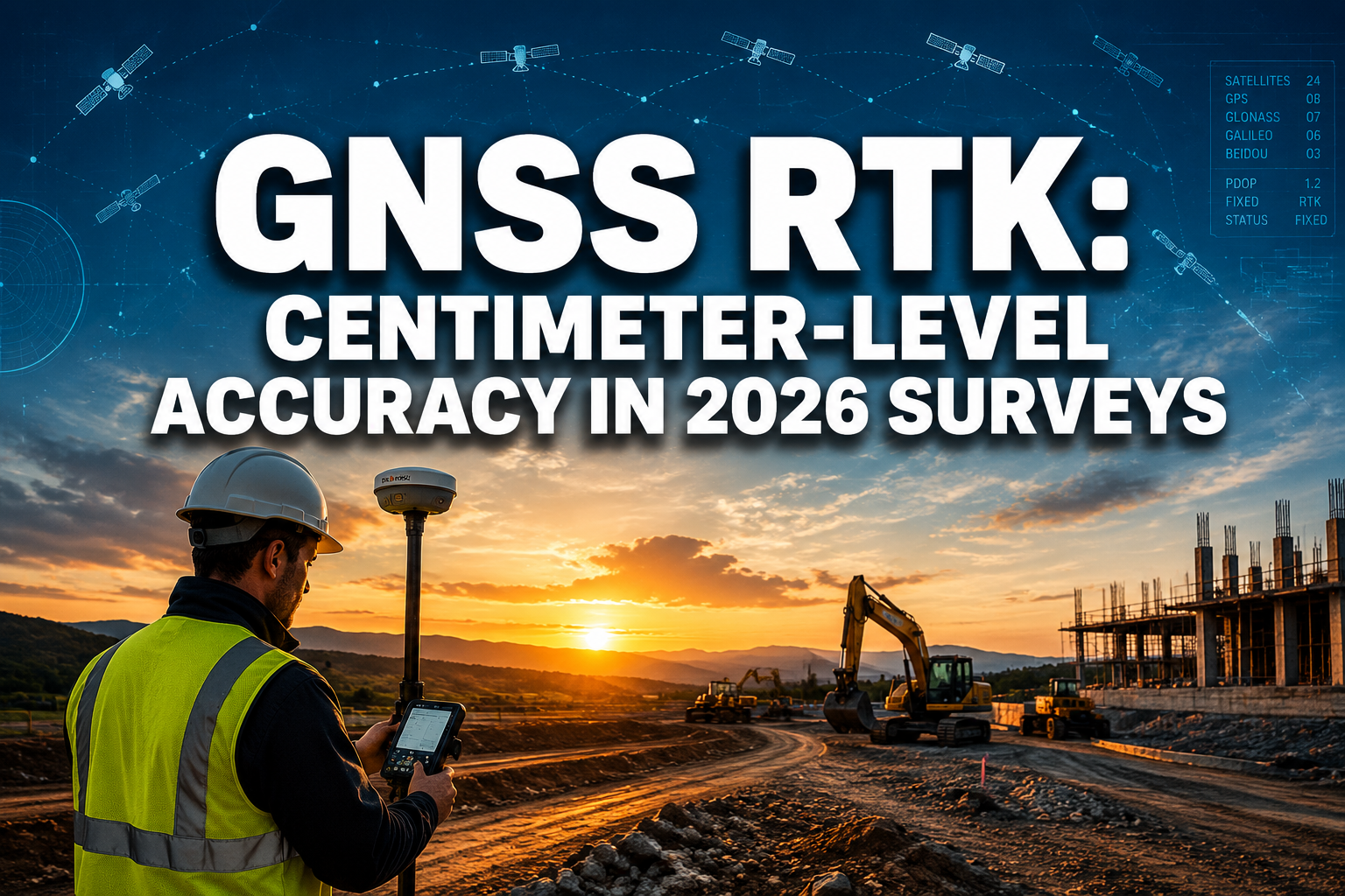
A standard smartphone GPS is accurate to roughly three to five meters on a good day. For navigating to a coffee shop, that margin is acceptable. For staking a property boundary, designing a road alignment, or monitoring structural movement, it is completely useless. That gap between consumer-grade positioning and professional survey-grade precision is exactly where GNSS RTK and GPS Enhancements: Achieving Centimeter-Level Accuracy in 2026 Surveys sits — and the technology closing that gap has never been more capable or accessible.
Real-Time Kinematic (RTK) positioning now routinely delivers horizontal accuracies of one to two centimeters and vertical accuracies of two to three centimeters in the field [1]. Combined with new multi-constellation receivers, modernized correction services, and the emerging PPP-RTK hybrid approach, 2026 is a landmark year for survey-grade GNSS.
Key Takeaways
- RTK GNSS achieves centimeter-level accuracy by resolving carrier-phase ambiguities using real-time corrections from a base station or network.
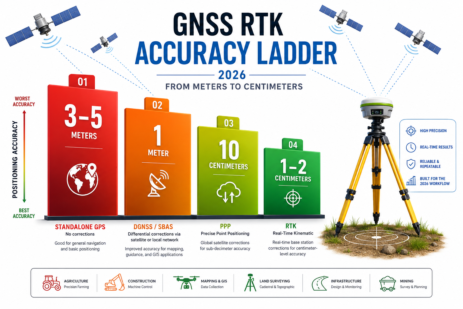
- The accuracy ladder runs from standalone GPS (3-5 m) through DGNSS/SBAS (sub-meter) and PPP (decimeter) to RTK (1-2 cm).
- Network RTK and Continuously Operating Reference Station (CORS) services eliminate the need for a dedicated base station in most urban and suburban surveys.
- PPP-RTK fusion is shortening convergence times from minutes to seconds, making high-precision positioning viable for autonomous vehicles and remote fieldwork.
- Proper field setup, multipath mitigation, and PDOP monitoring remain the most critical error-reduction steps regardless of which RTK system is used.
Understanding the Accuracy Ladder: From GPS to RTK
Before examining the latest enhancements, it helps to understand why different GNSS modes produce such different results.
Standalone GNSS
A basic single-frequency GPS receiver calculates position by measuring the travel time of pseudorandom code signals from at least four satellites. Atmospheric delays, satellite clock drift, and multipath reflections introduce errors that typically sum to three to five meters horizontally [3]. This is sufficient for general navigation but falls far short of survey requirements.
DGNSS and SBAS
Differential GNSS (DGNSS) and Satellite-Based Augmentation Systems (SBAS) such as EGNOS in Europe or WAAS in North America broadcast code-level corrections that reduce errors to roughly one meter. These systems are free to use and require no additional hardware beyond a compatible receiver, making them popular for GIS data collection where sub-meter accuracy is acceptable [9].
Precise Point Positioning (PPP)
PPP uses precise satellite orbit and clock products — broadcast by services such as the IGS or commercial providers — to achieve decimeter-level accuracy without a local base station. The drawback is convergence time: a PPP solution can take 20 to 40 minutes to stabilize, which limits its usefulness in fast-paced fieldwork [4].
RTK: The Centimeter Standard
RTK resolves the carrier-phase ambiguity of the GNSS signal — essentially counting the number of complete wavelengths between satellite and receiver — to achieve one to two centimeter horizontal accuracy and two to three centimeter vertical accuracy [1]. The key is a real-time correction stream from a base station or reference network delivered to the rover via radio, cellular data, or internet. Once the receiver achieves a "fixed" solution (ambiguity resolution confirmed), the position is survey-grade.
| Mode | Typical Horizontal Accuracy | Correction Source | Convergence Time |
|---|---|---|---|
| Standalone GPS | 3-5 m | None | Instant |
| DGNSS / SBAS | 0.5-1 m | Satellite broadcast | Instant |
| PPP | 5-20 cm | Precise orbit/clock data | 20-40 min |
| RTK | 1-2 cm | Local base or CORS network | 5-60 sec |
| PPP-RTK | 1-5 cm | Hybrid network corrections | 5-30 sec |
How RTK Systems Work in the Field
The Base-Rover Architecture
A classic RTK setup uses two GNSS receivers: a base station placed over a known control point and a rover carried by the surveyor. The base continuously measures its own position, computes the difference between measured and known coordinates, and transmits those corrections to the rover. The rover applies the corrections and resolves carrier-phase ambiguities to produce a centimeter-accurate position [6].
The correction link has traditionally been a UHF radio (typically 450-470 MHz), which works reliably over open terrain up to 10-15 km. Modern systems increasingly use cellular data modems (4G/5G) or dual radio-plus-cellular configurations for redundancy.
Network RTK and CORS Services
Setting up and maintaining a dedicated base station adds cost, time, and logistical complexity. Network RTK solves this by connecting the rover directly to a network of Continuously Operating Reference Stations (CORS) via the internet [5]. The network software interpolates corrections from multiple reference stations and delivers a virtual reference station (VRS) correction stream tailored to the rover's approximate location.
In the United Kingdom, Ordnance Survey's OS Net provides a dense CORS infrastructure that underpins most professional survey work. Similar national networks operate across Europe, North America, and Asia-Pacific. For boundary surveys and other legally sensitive work, connecting to a national CORS network provides a traceable, independently verified correction source that strengthens the defensibility of results.
"Network RTK has fundamentally changed how surveyors operate — a single rover connected to a CORS network can now achieve the same centimeter-level accuracy that once required two receivers and a dedicated base station."
Initialization and Fixed Solutions
After the rover receives corrections, it enters an initialization phase during which the receiver tests integer ambiguity hypotheses. Most modern multi-constellation receivers achieve a fixed solution in 5 to 30 seconds under open-sky conditions [1]. A "float" solution — where ambiguities are estimated but not confirmed as integers — is less accurate (typically 20-50 cm) and should not be used for precision surveys. Always confirm a fixed solution before recording observations.

GNSS RTK and GPS Enhancements: Achieving Centimeter-Level Accuracy in 2026 Surveys — The Latest Advances
The technology behind GNSS RTK and GPS Enhancements: Achieving Centimeter-Level Accuracy in 2026 Surveys has accelerated significantly over the past two years. Three developments stand out in 2026.
Multi-Constellation and Multi-Frequency Receivers
Early RTK systems relied almost entirely on GPS L1/L2 signals. Modern receivers track signals from GPS, GLONASS, Galileo, BeiDou, and QZSS simultaneously, often on three or more frequency bands (L1, L2, L5, E5a, B2a). More satellites in view means a stronger geometry (lower PDOP), faster ambiguity resolution, and better performance in challenging environments such as urban canyons, forests, and construction sites [9].
The addition of the L5 / E5a band is particularly significant. These signals are broadcast at higher power, use a wider bandwidth, and are less susceptible to multipath and ionospheric delay than L1 — translating directly into faster, more reliable fixed solutions [4].
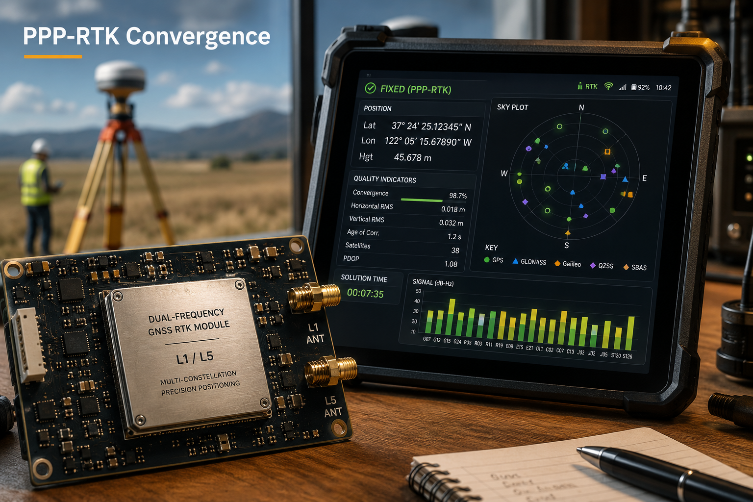
PPP-RTK: Convergence Without Compromise
PPP-RTK is the most consequential development in precision GNSS in recent years. It combines the global reach of PPP (no local base station required) with the rapid ambiguity resolution of RTK. State-space corrections — including precise satellite orbits, clocks, phase biases, and atmospheric models — are delivered to the receiver, enabling centimeter-level accuracy with convergence times of five to thirty seconds [10].
A 2025 peer-reviewed study published in Satellite Navigation demonstrated that PPP-RTK systems using Galileo E6-HAS corrections achieved horizontal accuracies below three centimeters with convergence times under one minute in open-sky conditions [10]. This is a transformative result for remote surveys where establishing a local base station is impractical.
High-Precision GNSS Modules for Autonomy and Compact Instruments
The autonomous vehicle and robotics markets are driving rapid miniaturization of RTK-grade GNSS hardware. In 2026, several manufacturers have launched compact dual-frequency RTK modules targeting survey drones, autonomous construction equipment, and precision agriculture platforms [7]. These modules integrate L1/L5 multi-constellation tracking, built-in IMU tilt compensation, and cellular correction connectivity into form factors small enough for handheld instruments.
For professional surveyors, tilt compensation is a practical game-changer. Traditional RTK rovers require the pole to be perfectly vertical for accurate measurements. IMU-assisted tilt compensation allows observations to be taken with the pole leaning up to 60 degrees, dramatically improving productivity in confined spaces — a real advantage when conducting monitoring surveys on complex structures or tight urban sites.
Field Setup Guide and Error-Reduction Best Practices
Even the most advanced RTK system will underperform if field procedures are poor. The following practices reflect current industry consensus for reliable centimeter-level results.
Pre-Survey Planning
- Check PDOP forecasts. Use satellite prediction software to schedule observations when PDOP is below 3.0. Values above 4.0 significantly degrade accuracy.
- Review the correction service. Confirm CORS network connectivity and subscription status before mobilizing. Download the network's coordinate reference frame documentation — mismatched datums are a common source of systematic error.
- Identify multipath risk zones. Buildings, vehicles, and water bodies reflect GNSS signals and corrupt measurements. Mark these on the site plan and plan observation positions accordingly.
Equipment Setup
- Mount the base station (if using a local base) over a stable, known control point using a precise centering tribrach. Even a 2 mm centering error propagates directly into all rover observations.
- Use a fixed-height pole or measure the antenna height carefully to the nearest millimeter. Antenna height errors are the single most common source of systematic vertical error in RTK surveys.
- Enable all available constellations and frequency bands in the receiver settings. There is rarely a reason to restrict tracking in 2026 hardware.
During Observation
- Wait for a confirmed fixed solution before recording any point. Most field controllers display solution status prominently — do not accept "float" readings.
- Observe each point for a minimum of three to five epochs (seconds) and average the readings. For control points, extend this to 60 seconds or more.
- Re-initialize and re-observe any point where the fixed solution was lost during measurement.
- Record redundant observations on at least 10% of points and check against independent control to detect systematic errors.
Common Error Sources and Mitigations
| Error Source | Typical Magnitude | Mitigation |
|---|---|---|
| Multipath reflections | 1-5 cm | Observe away from reflective surfaces; use choke-ring antennas |
| Antenna height blunder | Variable | Double-check and record height; use fixed-height poles |
| NTRIP connection dropout | Position reverts to float | Use dual radio/cellular; monitor solution status |
| Ionospheric scintillation | 1-10 cm | Avoid observations during geomagnetic storms; use L5 band |
| Datum/coordinate frame mismatch | Decimeters to meters | Verify CORS network datum; apply correct transformation |
| Poor satellite geometry (high PDOP) | Proportional to PDOP | Schedule observations; use multi-constellation to improve geometry |
Practical Applications: Where Centimeter Accuracy Changes Outcomes
The value of centimeter-level RTK positioning extends well beyond traditional land surveying. In 2026, professionals across multiple disciplines rely on it.
Land and boundary surveys demand the highest positional accuracy and legal defensibility. Chartered surveyors working on boundary surveys use RTK to establish and verify boundary markers with millimeter-level confidence, reducing the risk of costly disputes. For firms providing expert witness services in boundary or land disputes, RTK-derived evidence carries significant weight in legal proceedings.
Structural monitoring uses RTK and its close relative, static GNSS, to detect millimeter-scale movement in bridges, retaining walls, embankments, and buildings over time. This is directly relevant to surveys for subsidence where precise, repeatable positional data is needed to track settlement rates and trigger intervention thresholds.
Construction and infrastructure projects use RTK for machine control, volume calculations, and as-built verification. The ability to stake out design coordinates in real time — without setting out pegs manually — has transformed earthworks productivity.
Drone and UAV photogrammetry increasingly relies on RTK-enabled drones to achieve ground sample distances below one centimeter without the need for dense ground control point networks. This reduces fieldwork time and cost while maintaining accuracy standards.
For property professionals seeking local chartered surveyors who apply the latest GNSS technology, understanding these capabilities helps set appropriate expectations for deliverable accuracy and turnaround time.
Choosing the Right RTK System for Your Survey Needs
With the market now offering everything from sub-£500 compact modules to £30,000+ integrated total station / GNSS systems, selection requires careful thought.
Key selection criteria:
- Constellation and frequency support: Prioritize receivers that track at minimum GPS + Galileo + BeiDou on L1/L2/L5. This combination maximizes satellite availability globally.
- Correction connectivity: Cellular NTRIP is now standard for urban and suburban work. Radio link capability remains essential for remote sites without data coverage.
- IMU tilt compensation: Valuable for confined or vegetated sites. Verify the manufacturer's stated tilt accuracy (typically 2-3 cm at 30 degrees tilt).
- Integration with office software: Ensure the receiver outputs data in formats compatible with your CAD, GIS, or BIM workflow (LandXML, DXF, Shapefile, etc.).
- Support and calibration: RTK equipment requires periodic calibration and firmware updates. Choose a supplier with local technical support.
For professionals engaged in residential structural engineering or monitoring surveys, investing in a network RTK subscription alongside a quality multi-frequency rover typically delivers the best combination of accuracy, flexibility, and cost-efficiency.
Conclusion
GNSS RTK and GPS Enhancements: Achieving Centimeter-Level Accuracy in 2026 Surveys represents one of the most mature and rapidly advancing areas of geospatial technology. The convergence of multi-constellation receivers, L5-band signals, network CORS infrastructure, and PPP-RTK hybrid corrections has made centimeter-level positioning faster, more reliable, and more accessible than at any previous point.
Actionable next steps for survey professionals in 2026:
- Audit your current equipment. If your RTK receiver is more than four years old, evaluate whether it supports L5/E5a signals and current multi-constellation tracking. Upgrading to a dual-frequency multi-constellation receiver is the single highest-impact hardware investment available.
- Subscribe to a national CORS network. Eliminating the base station from routine workflows reduces setup time, removes a major source of systematic error, and provides a legally traceable correction source.
- Implement a field QA checklist. Standardize PDOP checks, fixed-solution confirmation, antenna height recording, and redundant observation protocols across your team.
- Monitor PPP-RTK developments. Services using Galileo E6-HAS and similar state-space correction streams are maturing rapidly. Piloting PPP-RTK for remote or international projects in 2026 is now a realistic option.
- Document your methodology. For boundary surveys and any work that may face legal scrutiny, maintain a complete record of equipment, correction source, solution type, PDOP values, and antenna heights for every session.
The centimeter-accurate future of surveying is not approaching — it has arrived. The professionals who master these systems and embed rigorous field procedures will consistently deliver results that stand up to the highest technical and legal standards.
References
[1] What Is Rtk Gps And How Does It Improve Positioning Accuracy – https://navigation.chcnav.com/about/news/2026/what-is-rtk-gps-and-how-does-it-improve-positioning-accuracy
[2] eurekalert – https://www.eurekalert.org/news-releases/1090255
[3] Introduction To Rtk Gps – https://blog.emlid.com/introduction-to-rtk-gps/
[4] Gnss Receivers – https://pointonenav.com/insights/gnss-receivers/
[5] Net Rtk – https://www.geodetic.gov.hk/en/satref/Net_RTK.htm
[6] What Is Rtk Real Time Kinematic – https://pointonenav.com/news/what-is-rtk-real-time-kinematic/
[7] Locosys Targets High Precision Positioning Market – https://www.locosystech.com/en/news/LOCOSYS-Targets-High-Precision%20Positioning-Market.html
[9] Tech Talk Understanding Gnss And Rtk Unlocking Centimeter Level Precision – https://www.allynav.com/blog/geospatial/tech-talk-understanding-gnss-and-rtk-unlocking-centimeter-level-precision/
[10] S43020 025 00169 6 – https://satellite-navigation.springeropen.com/articles/10.1186/s43020-025-00169-6