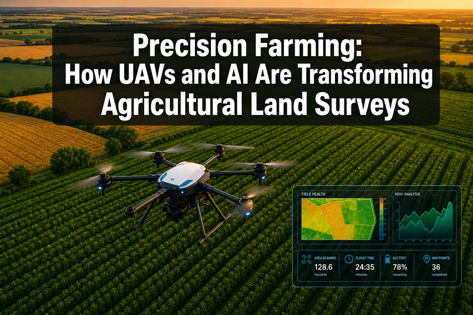
A single agricultural drone can survey 200 acres in under four hours — a task that would take a team of field technicians several days on foot. That gap in efficiency is not just a convenience; it is reshaping how farmers, agronomists, and land surveyors understand and manage the land beneath their feet. Across the globe in 2026, precision farming: how UAVs and AI are transforming agricultural land surveys has become one of the most consequential stories in modern land management.
This article examines the technology driving that transformation, the measurable returns it delivers, and the practical steps farmers and surveyors can take to adopt it.
Key Takeaways
- UAV-based remote sensing combined with AI analysis can increase crop yields by up to 8% while cutting input costs by 20% or more.
- AI algorithms process multispectral, thermal, and LiDAR drone data to produce crop health maps, soil moisture readings, and yield predictions in near real time.
- Integrated aerial and ground-robot systems create highly accurate 3D field maps that support targeted interventions rather than blanket treatments.
- The return on investment for UAV survey programs is measurable within a single growing season for most commercial operations.
- Professional land surveyors are incorporating drone data into boundary, monitoring, and structural assessments, expanding the value of traditional surveying services.
The Technology Stack Behind Modern Agricultural Surveys
Understanding precision farming: how UAVs and AI are transforming agricultural land surveys starts with the hardware and software working together. Modern agricultural UAVs are not simple camera platforms. They carry a suite of sensors that capture data invisible to the human eye.
Sensor Types and What They Detect
| Sensor Type | Primary Use | Data Output |
|---|---|---|
| RGB Camera | Canopy cover, crop stand counts | High-resolution ortho-mosaics |
| Multispectral | Chlorophyll and nitrogen levels | NDVI, NDRE vegetation indices |
| Thermal Infrared | Water stress, irrigation mapping | Temperature gradient maps |
| LiDAR | Terrain elevation, plant height | 3D point clouds |
| Millimeter-Wave Radar | Complex terrain perception | Elevation and obstacle data |
A May 2026 study introduced a rotating millimeter-wave radar system specifically designed for agricultural UAVs, improving terrain perception in uneven farmland environments and reducing collision risk during low-altitude survey passes [7]. This matters because accurate terrain-following directly improves the quality of every other sensor reading taken during the same flight.
How AI Turns Raw Data Into Actionable Intelligence
Raw sensor data is only useful once it has been processed. This is where artificial intelligence changes the equation. A survey published in Neurocomputing highlights how AI algorithms integrated with UAV sensing systems can analyze vast volumes of field data for crop monitoring, disease detection, and yield prediction at a speed and scale no human analyst could match [3].
The AI pipeline typically works in three stages:
- Data ingestion — drone imagery and sensor readings are uploaded to a cloud platform or processed on-board.
- Feature extraction — machine learning models identify patterns such as stressed crop zones, weed clusters, or soil moisture variation.
- Decision output — the system generates prescription maps that direct specific interventions: variable-rate fertilizer application, targeted irrigation, or selective spraying.
A 2022 deep learning study demonstrated a model capable of segmenting crops from weeds in both ground-level and UAV imagery within the same framework, enabling consistent weed management recommendations regardless of the data source [10].
"The shift from blanket field treatments to prescription-based interventions is the single biggest driver of cost reduction in modern arable farming."
Crop Monitoring, Soil Analysis, and Yield Prediction in Practice
The real-world applications of precision farming: how UAVs and AI are transforming agricultural land surveys span the entire growing cycle, from pre-season soil assessment through to harvest planning.
Pre-Season Soil and Terrain Mapping
Before a seed goes in the ground, UAVs equipped with multispectral and thermal sensors can map soil organic matter variation, drainage patterns, and compaction zones across an entire field. This data feeds into variable-rate seeding plans, ensuring higher seed density in productive zones and lower density in marginal areas.
The AgriColMap project demonstrated a method for combining UAV aerial data with ground vehicle sensor readings to create accurate 3D field maps, providing a level of spatial detail that traditional soil sampling grids cannot match [9]. For large arable operations, this means fewer soil cores, lower lab costs, and better spatial resolution.
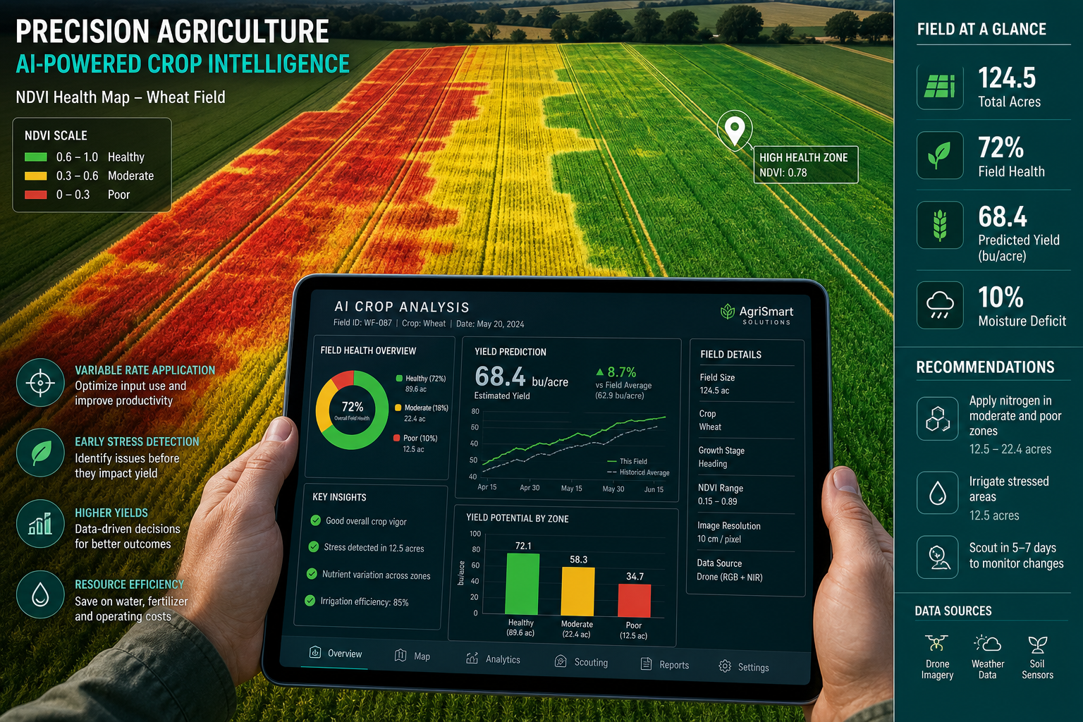
In-Season Crop Monitoring
During the growing season, repeat drone flights at two- to three-week intervals build a time-series record of crop development. AI models compare current NDVI readings against historical baselines and flag anomalies — early signs of fungal disease, nutrient deficiency, or pest pressure — before they become visible to the naked eye.
Skysense has deployed autonomous drone patrol systems that use AI to detect and deter bird damage in real time, while simultaneously providing accurate stand counts that inform replanting decisions [5]. This dual-use approach — protection and data collection in a single flight — illustrates how UAV programs generate compounding value.
A systematic literature review published in Ecological Informatics in December 2023 confirmed the rapid proliferation of UAV remote sensing in precision agriculture, noting its pivotal contribution to sustainable production systems [2]. The review found that crop monitoring and disease detection were the two most common applications, followed by yield estimation.
Yield Prediction and Harvest Planning
Late-season UAV surveys, combined with AI yield models trained on multi-year field data, can produce field-level yield estimates with accuracy rates that support pre-harvest logistics planning. Knowing which field sections will yield above or below average allows farm managers to allocate combine harvester time, grain storage, and haulage capacity more efficiently.
A March 2025 article in the European Journal of Agronomy highlighted how deep learning integration with UAV platforms is transforming yield prediction accuracy, moving the technology from experimental tool to operational standard in commercial farming [4].
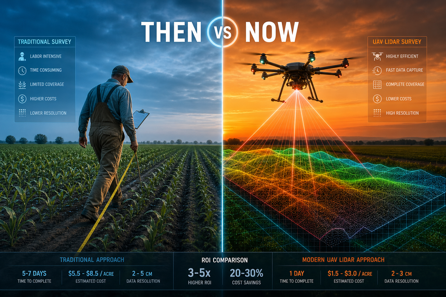
ROI Calculations: What Farmers and Surveyors Can Expect
The business case for UAV and AI adoption in agricultural land surveys is no longer theoretical. Verified field data now supports clear return-on-investment calculations.
Farmer ROI: A Worked Example
Consider a 500-acre arable operation growing winter wheat. The table below models typical costs and returns from a UAV precision agriculture program.
| Cost / Benefit Item | Annual Figure |
|---|---|
| UAV survey program (outsourced) | -£4,500 |
| AI analysis platform subscription | -£1,200 |
| Reduction in fertilizer use (20% saving) | +£6,800 |
| Reduction in pesticide use | +£3,200 |
| Yield improvement (8% on base revenue) | +£9,400 |
| Net annual benefit | +£13,700 |
Verde Drones reports that AI-driven precision agriculture services have delivered an 8% increase in yields and a 20% reduction in input usage, with spray costs cut by up to 70% on some operations [1]. At those figures, a 500-acre farm can expect to recover its program costs within the first season and generate substantial net savings in subsequent years.
Surveyor ROI: Expanding Service Value
For professional land surveyors, UAV integration opens new revenue streams and improves the quality of existing services. Boundary surveys benefit from drone-captured ortho-mosaics that provide millimetre-accurate feature mapping across large parcels. Monitoring surveys can track land movement, erosion, or drainage changes over time using repeat UAV flights.
Surveyors offering structural surveys on farm buildings can use thermal drone imagery to identify heat loss, moisture ingress, or roof defects without scaffolding. This reduces access costs and speeds up report turnaround. For clients interested in understanding the full scope of available survey services, a review of professional surveying options provides a useful starting point.
The integration of UAV data also strengthens the evidential basis for expert witness reports in agricultural land disputes, where precise boundary and drainage evidence can be decisive.
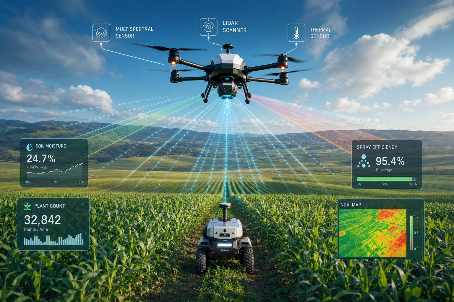
Integrated Systems: UAVs, Ground Robots, and Collaborative Mapping
The next stage of precision farming moves beyond standalone drone flights toward coordinated systems where aerial and ground-based robots work together.
The Flourish Model
The Flourish research project developed an integrated system combining UAVs and autonomous ground vehicles for crop monitoring and selective spraying [8]. The UAV provides a rapid high-level survey, identifying target zones. The ground vehicle then navigates to those zones for close-range intervention — applying herbicide to a specific weed patch, for example, rather than spraying an entire field.
This aerial-ground collaboration reduces chemical use further than either platform could achieve alone, and it produces a richer dataset by combining the wide-area perspective of the drone with the ground-level detail of the robot.
Precision Spraying and Input Reduction
A 2021 survey in Agronomy documented the increasing use of UAVs in agriculture, with particular emphasis on precision spraying as a high-value application [6]. Variable-rate spraying guided by AI prescription maps means that only the areas that need treatment receive it. The environmental and financial benefits are significant: less chemical runoff, lower input costs, and reduced regulatory risk.
For surveyors working on drainage surveys for agricultural properties, UAV-derived drainage mapping provides a level of spatial detail that transforms the quality of drainage assessments and recommendations.
Data Standards and Integration Challenges
Despite the clear benefits, adoption is not without friction. Key challenges include:
- Data format compatibility between UAV platforms, AI analysis tools, and farm management software.
- Regulatory compliance for commercial UAV operations, which varies by country and flight zone.
- Skill gaps among farm staff and surveyors in interpreting AI-generated prescription maps.
- Data ownership and privacy concerns when third-party platforms process sensitive field data.
Addressing these challenges typically requires a structured onboarding process, clear data-sharing agreements, and investment in staff training. Surveyors who position themselves as interpreters of UAV data — not just collectors of it — add significant value to their clients.
Practical Steps for Adoption in 2026
Whether the goal is to improve farm profitability or expand a surveying practice, the path to UAV and AI integration follows a logical sequence.
For farmers:
- Commission a baseline UAV survey to establish field-level variability maps before the next growing season.
- Pilot variable-rate fertilizer application on one field using an AI prescription map and compare yield outcomes against a control field.
- Evaluate outsourced drone service providers against in-house UAV purchase based on acreage and frequency of required surveys.
For land surveyors:
- Invest in UAV operator certification and integrate drone capture into boundary survey and monitoring survey workflows.
- Partner with AI analysis platform providers to offer crop health reporting as an add-on service for agricultural clients.
- Use thermal UAV imagery to enhance roof surveys and building condition assessments on farm properties.
- Explore how drone-derived 3D maps can support subsidence surveys on agricultural land where ground movement affects field drainage and crop performance.
Conclusion
Precision farming: how UAVs and AI are transforming agricultural land surveys is no longer a future-facing concept — it is an operational reality delivering measurable financial returns in 2026. The evidence is clear: farms using AI-guided drone programs are achieving yield improvements of around 8%, cutting input costs by 20% or more, and reducing spray costs by up to 70% [1]. Integrated aerial and ground-robot systems are pushing those figures further by enabling targeted, field-scale interventions that blanket treatments cannot match [8].
For land surveyors, the opportunity is equally significant. UAV data enhances the precision and evidential strength of boundary, monitoring, drainage, and structural assessments. Surveyors who build UAV and AI competency into their service offering are better positioned to serve agricultural clients and command higher fees for more comprehensive reports.
Actionable next steps:
- Commission or conduct a baseline UAV survey of key agricultural parcels before the next growing season.
- Select an AI analysis platform and run a single-season pilot comparing prescription-based inputs against standard practice.
- Review current surveying workflows and identify which service lines — boundary, monitoring, drainage, or structural — would benefit most from UAV data integration.
- Engage with local regulatory bodies to ensure UAV operations comply with current airspace and data protection requirements.
The technology is proven. The ROI is documented. The question in 2026 is not whether to adopt UAV and AI-powered agricultural land surveys — it is how quickly the transition can be made.
References
[1] Verde Drones – https://verdedrones.com/?utm_source=openai
[2] S1574954123003345 – https://www.sciencedirect.com/science/article/abs/pii/S1574954123003345?utm_source=openai
[3] S0925231222013996 – https://www.sciencedirect.com/science/article/pii/S0925231222013996?utm_source=openai
[4] S1161030124003988 – https://www.sciencedirect.com/science/article/pii/S1161030124003988?utm_source=openai
[5] Skysense – https://skysense.ag/?utm_source=openai
[6] MDPI Agronomy – https://www.mdpi.com/2073-4395/11/2/203/htm?utm_source=openai
[7] arXiv 2605.01340 – https://arxiv.org/abs/2605.01340?utm_source=openai
[8] arXiv 1911.03098 – https://arxiv.org/abs/1911.03098?utm_source=openai
[9] arXiv 1810.00457 – https://arxiv.org/abs/1810.00457?utm_source=openai
[10] arXiv 2210.11545 – https://arxiv.org/abs/2210.11545?utm_source=openai