By 2026, 73% of construction professionals incorporate Building Information Modelling into their daily workflows — up from just over 10% a decade ago [1]. Yet despite this surge, many land surveyors still hand off geospatial data as static files that sit disconnected from the live BIM environment. The result: clashes, rework, and costly delays that could be eliminated at source. This guide explains precisely how surveyors can embed their data directly into BIM models, cut conflicts, and drive measurable efficiency gains across the project lifecycle.

Key Takeaways
- BIM integration for land surveyors enables seamless geospatial data fusion, reducing design conflicts and site errors before construction begins.
- Combining survey data with GIS inside a BIM environment gives all stakeholders a single, authoritative spatial reference.
- LiDAR, drone photogrammetry, and total station data can all be converted into BIM-compatible formats using established workflows in 2026.
- Standardised data models and interoperability protocols (IFC, CityGML) are essential for reliable information exchange between surveying and BIM platforms.
- Firms that have adopted BIM-GIS fusion report faster decision-making, fewer regulatory compliance issues, and lower overall project costs.
Why Surveyors Are Now Central to the BIM Workflow
Historically, land surveyors delivered a finished drawing or point cloud and stepped back. The design team then reinterpreted that data inside their own modelling tools, introducing errors at every translation step. Modern BIM integration for land surveyors eliminates that gap by making geospatial data a live, referenced layer inside the model itself.
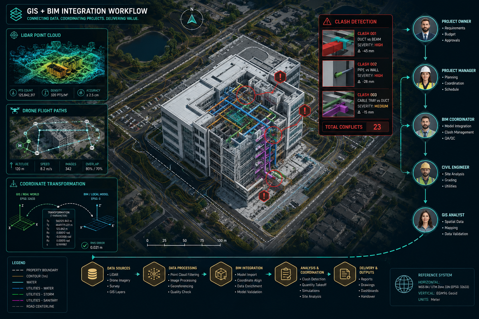
The shift matters because BIM is no longer just a design tool. It is the master information environment for planning, construction, and asset management. When survey data is embedded correctly, every discipline — structural engineers, MEP contractors, project managers — works from the same verified ground truth. Conflicts are detected in the model, not on site.
The core principle is straightforward: survey data must carry its coordinate reference system (CRS) metadata intact, be formatted to an open standard the BIM platform can consume, and be updated whenever conditions on site change.
For surveyors working across the South East of England, where dense urban environments create complex underground utilities and tight site boundaries, this precision is especially critical. Teams at chartered surveyors in London and chartered surveyors in North London regularly encounter projects where millimetre-accurate georeferencing separates a successful build from an expensive dispute.
Understanding the BIM-GIS Integration Framework
What BIM-GIS Fusion Actually Means
BIM models describe individual buildings and structures in fine detail. Geographic Information Systems (GIS) describe the world at a landscape scale — topography, utilities, land use, transport networks, environmental constraints. Fusing the two creates something more powerful than either alone: a spatially accurate, data-rich model of a building within its real-world context [2].
Tools like Esri's ArcGIS GeoBIM allow project teams to explore and collaborate on BIM models within a geospatial context, linking ArcGIS directly with Autodesk Construction Cloud and BIM 360 [3]. For land surveyors, this means their topographic surveys, boundary data, and utility records can be visualised alongside the architectural model in a shared environment accessible to every stakeholder.
The Data Formats That Make It Work
Interoperability depends on using the right formats. The table below summarises the key standards in use in 2026:
| Format | Primary Use | BIM/GIS Compatibility |
|---|---|---|
| IFC (Industry Foundation Classes) | BIM object exchange | BIM-native; GIS via conversion |
| CityGML | Urban-scale 3D models | GIS-native; BIM via conversion |
| LandXML | Survey and civil engineering data | Both, widely supported |
| LAS/LAZ | LiDAR point clouds | Both, with processing |
| GeoJSON / Shapefile | 2D/3D geospatial features | GIS-native; BIM via plugin |
Research consistently highlights the need for unified data models to facilitate seamless information flow between systems [5]. The IFC standard, maintained by buildingSMART, is the most widely adopted open format for BIM data exchange and should be the default output format for any survey data destined for a BIM environment.
Coordinate Reference Systems: The Foundation of Accurate Fusion
The single most common cause of misaligned BIM-GIS data is a mismatch in coordinate reference systems. A BIM model often uses a local project coordinate system, while GIS data uses a national or global CRS such as OSGB36 or WGS84.
Surveyors must:
- Define and document the project CRS at the outset
- Provide transformation parameters (shift vectors, rotation, scale) to the BIM manager
- Verify that all imported data layers share the same CRS before any design work begins
This is not a one-time task. Every new data delivery — updated topographic survey, as-built record, utility scan — must be checked for CRS consistency before it enters the model.
Embedding Survey Data into BIM Models: Step-by-Step Workflows
Step 1: Field Data Acquisition with BIM-Ready Outputs
The integration process begins in the field. Survey instruments and data collection methods must be configured to produce outputs that translate cleanly into BIM.
Total Station Surveys
Modern total stations can export point data directly in LandXML or CSV formats with full coordinate metadata. Surveyors should configure their data collectors to record feature codes that map to IFC object classifications, so that a kerb line, for example, is tagged as a civil infrastructure element rather than a generic polyline.
LiDAR Point Clouds
Terrestrial and airborne LiDAR produce dense point clouds in LAS or LAZ format. These can be imported into BIM platforms such as Autodesk Revit, Bentley ContextCapture, or Trimble Business Center. The key step is registration: aligning the point cloud to the project CRS using ground control points (GCPs) established by the surveyor.
Companies such as Delta Drone Solutions now offer survey-grade aerial mapping and LiDAR point clouds that produce BIM-compatible outputs directly, significantly reducing the post-processing burden on the survey team [4]. For complex sites, combining aerial LiDAR with ground-based scanning gives the most complete and accurate base model.
Drone Photogrammetry
UAV photogrammetry produces dense mesh models and orthomosaics. When GCPs are placed and measured to survey accuracy, the resulting models meet the tolerances required for BIM integration. Drone surveys are now a standard data collection method for large or difficult-to-access sites, delivering georeferenced outputs that slot directly into the BIM environment.
Step 2: Data Processing and Format Conversion
Raw field data rarely arrives in a BIM platform without processing. The workflow typically involves:
- Cleaning and filtering point cloud data to remove noise and vegetation
- Classifying points into ground, buildings, vegetation, and utilities
- Generating a triangulated irregular network (TIN) or mesh surface from ground points
- Exporting in the agreed project format (LandXML for civil surfaces, IFC for structural elements)
- Attaching metadata including CRS definition, accuracy statement, and survey date
Software commonly used in this stage in 2026 includes Autodesk Civil 3D, Trimble Business Center, Leica Cyclone, and FARO Scene. Each has direct export paths to the major BIM authoring platforms.
Step 3: Importing into the BIM Environment
With processed data in hand, the import into the BIM platform follows a defined protocol:
- Establish a shared coordinate origin agreed between the surveyor and BIM manager at project start
- Import the survey surface as a reference model, not a design element, so it cannot be accidentally edited
- Attach the point cloud as a linked file, allowing it to be updated when new survey data arrives
- Set visibility and clash detection rules so the survey model participates in all coordination checks
Autodesk Revit, the most widely used BIM authoring tool, supports direct import of LAS point clouds and LandXML surfaces. Bentley OpenRoads Designer and Trimble Quadri offer similar functionality with stronger civil engineering workflows.
Step 4: Ongoing Synchronisation and As-Built Recording
BIM integration is not a one-off event. As construction progresses, the surveyor's role is to keep the model updated with verified as-built positions. This involves:
- Regular site surveys at agreed construction milestones
- Uploading updated point clouds or survey models to the BIM Common Data Environment (CDE)
- Flagging deviations between design intent and as-built position for the project team to resolve
Monitoring surveys are particularly valuable here, providing continuous or periodic positional data that feeds directly into the BIM model and alerts the team to movement or settlement in real time.
Software Recommendations for BIM-GIS Integration in 2026
The market for BIM-GIS integration tools has matured considerably. The following platforms represent the leading options for land surveyors in 2026:
| Software | Strengths | Best For |
|---|---|---|
| Autodesk Civil 3D + Revit | Deep civil-BIM workflow, LandXML support | Mixed civil/building projects |
| Esri ArcGIS GeoBIM | Best-in-class GIS-BIM bridge, cloud collaboration | Infrastructure and urban projects |
| Bentley OpenRoads Designer | Powerful corridor and terrain modelling | Linear infrastructure |
| Trimble Business Center | Field-to-office survey workflow | Survey-led projects |
| Leica Cyclone REGISTER 360 | Point cloud registration and BIM export | Scan-heavy projects |
| FARO Scene + As-Built for Revit | Scan-to-BIM automation | Existing building capture |
The combination of ArcGIS GeoBIM with Autodesk Construction Cloud has become the dominant pairing for projects where geospatial context is as important as the building model itself [3]. For surveyors working on infrastructure delivery, Bentley's ecosystem offers the most integrated environment for combining survey, civil design, and BIM.
Real-World Case Studies: BIM-GIS Fusion in Practice
Infrastructure Delivery: HNTB
Engineering firm HNTB integrated BIM and GIS across major infrastructure projects, demonstrating that combining spatial analysis with detailed building models accelerates decision-making and reduces design conflicts [6]. Their approach involved establishing a shared geospatial reference framework at project inception, then feeding survey data into both the GIS environment and the BIM model simultaneously. The result was a single source of truth that eliminated the version-control problems that had previously caused delays.
Urban Development: Clash Detection at Scale
On a large mixed-use development in the South East, the project team used ArcGIS GeoBIM to overlay the proposed building model on existing utility records and topographic survey data. The spatial analysis identified 14 utility conflicts that would have required costly diversions if discovered during construction. Resolving them at design stage saved an estimated six weeks of programme time.
This kind of outcome is what drives adoption. When boundary surveys and topographic data are embedded in the BIM model from day one, the entire design team benefits from spatially accurate information rather than relying on assumptions.
Existing Building Capture: Scan-to-BIM
For refurbishment projects, scan-to-BIM workflows are now standard practice. A surveyor captures the existing structure with a terrestrial laser scanner, registers the point cloud to the project CRS, and delivers a Revit model that accurately represents existing conditions. Architects and engineers then design alterations directly on top of the verified survey model, eliminating the guesswork that previously led to site surprises.
Structural surveys and building surveys increasingly incorporate scan data as a matter of course, providing clients with a digital record of existing conditions that has value well beyond the immediate project.
Overcoming Common Integration Challenges

Challenge 1: Data Volume and Processing Time
LiDAR point clouds can run to hundreds of millions of points. Handling this volume requires dedicated processing hardware and efficient workflows. The practical solution is to deliver a processed, classified point cloud rather than raw data, and to use level-of-detail (LOD) management within the BIM platform so that only the relevant detail is loaded for each task.
Challenge 2: Maintaining Accuracy Through the Workflow
Every data conversion step carries a risk of introducing error. Surveyors should document the accuracy of their data at each stage and provide an accuracy statement with every delivery. The BIM manager should verify that imported data matches the stated accuracy by checking against independent control points.
Challenge 3: Regulatory Compliance
Automated compliance checking systems are being developed to ensure that BIM models adhere to regulatory standards, reducing errors and improving project outcomes [8]. For land surveyors, this means that the spatial data they provide must be structured to support automated rule checking — for example, confirming that a proposed structure sits within the legal boundary or meets setback requirements. Properly attributed IFC data makes this possible; a generic CAD file does not.
Challenge 4: Skills and Training
Research from academic institutions highlights growing demand for professionals who understand both geospatial science and BIM [7]. Surveyors who invest in BIM training — particularly in IFC data structures, CRS management, and BIM platform workflows — are significantly more valuable to project teams and command higher fees.
Understanding surveyor pricing in the context of BIM-capable services is important for clients too: the additional value delivered by a surveyor who can provide BIM-ready data justifies a premium over basic CAD deliverables.
The Future of Geospatial Data Fusion in Construction
The trajectory is clear. Research confirms that BIM-GIS integration will continue to advance, driven by improvements in sensor technology, cloud computing, and artificial intelligence [9]. Key developments to watch include:
- Digital twins: Real-time synchronisation between physical assets and their BIM-GIS models, fed by IoT sensors and continuous survey data
- AI-assisted clash detection: Machine learning models that predict conflicts before they appear in the model
- Automated as-built verification: Comparing construction progress against the design model using drone or robot-captured point clouds
- Standardised data exchanges: Continued development of IFC and CityGML to reduce conversion friction between BIM and GIS environments [5]
For surveyors, these developments represent an expanding role rather than a threat. The demand for accurate, well-structured geospatial data will only increase as construction projects become more data-intensive.
Conclusion
BIM integration for land surveyors is no longer an optional upgrade — it is the professional standard that clients, contractors, and regulators increasingly expect. The pathway is well-defined: acquire field data with BIM-ready outputs, process it to open standards, embed it in the BIM model with correct CRS metadata, and maintain it throughout the project lifecycle.
Actionable next steps for surveyors in 2026:
- Audit your current deliverable formats and identify which can be upgraded to LandXML or IFC without significant additional cost.
- Establish a standard project CRS protocol and share it with BIM managers at project kick-off.
- Invest in training on at least one major BIM platform — Autodesk Civil 3D, Revit, or Bentley OpenRoads — to understand how your data is consumed.
- Explore drone and LiDAR acquisition methods that produce BIM-compatible point clouds directly.
- Position BIM-ready data delivery as a distinct service offering, priced to reflect the additional value it provides to the project team.
Firms that make this transition will find themselves at the centre of the construction workflow rather than at its periphery. The geospatial expertise that land surveyors already possess is precisely what BIM needs to be spatially credible — the opportunity is to make that expertise visible inside the model where it can do the most good.
For specialist surveying services that understand the demands of modern construction projects, local chartered surveyors with BIM experience can provide the precise, well-structured data that today's projects require.
References
[1] Bim Integration For Land Surveyors Enhancing Construction Efficiency In 2026 – https://kingstonsurveyors.com/bim-integration-for-land-surveyors-enhancing-construction-efficiency-in-2026/?utm_source=openai
[2] Geobim – https://www.esri.com/about/newsroom/arcuser/geobim?utm_source=openai
[3] Overview – https://www.esri.com/en-us/arcgis/products/arcgis-geobim/overview?utm_source=openai
[4] deltadronesolutions – https://www.deltadronesolutions.com/?utm_source=openai
[5] S0926580522000395 – https://www.sciencedirect.com/science/article/pii/S0926580522000395?utm_source=openai
[6] Hntb Bim Gis Story – https://www.autodesk.com/customer-stories/hntb-bim-gis-story?utm_source=openai
[7] Trends And Opportunities Of Bim Gis Integration In The Architectu – https://researchportal.hkust.edu.hk/en/publications/trends-and-opportunities-of-bim-gis-integration-in-the-architectu/?utm_source=openai
[8] arxiv – https://arxiv.org/abs/2606.12065?utm_source=openai
[9] S0926580518309828 – https://www.sciencedirect.com/science/article/pii/S0926580518309828?utm_source=openai