Over 60% of party wall disputes in the UK stem from inadequate documentation of existing conditions before construction begins — a problem that Building Information Modelling is now directly solving. As excavation projects and boundary works accelerate across UK cities in 2026, the integration of BIM into party wall surveying has moved from a niche advantage to a professional necessity.
Building Information Modelling in Party Wall Surveys: Enhancing Accuracy for 2026 Boundary and Excavation Works sits at the intersection of legal obligation, technical precision, and digital innovation. This article explores how BIM adoption is reshaping the way surveyors serve party wall notices, compile schedules of condition, and navigate disputes — with measurable benefits for building owners and their neighbours alike.
Key Takeaways 📌
- BIM is a data-rich process, not just 3D software — it creates auditable, legally defensible records ideal for party wall matters.
- Precise 3D modelling reduces boundary disputes and excavation conflicts by establishing clear, shared digital baselines before work starts.
- RICS supports BIM integration in surveying practice, aligning with compliance requirements under the Party Wall etc. Act 1996.
- Schedules of condition produced with BIM point cloud data are significantly more accurate and defensible than traditional photo-based records.
- Early BIM adoption in 2026 gives chartered surveyors a competitive edge and reduces costly neighbour conflicts.

What Is BIM and Why Does It Matter for Party Wall Surveys?
The Royal Institution of Chartered Surveyors (RICS) defines Building Information Modelling as "the creation and maintenance of a database of information relating to a building," emphasising that BIM is fundamentally a process, not merely a collection of 3D drawings [3]. This distinction is critical for party wall surveyors: the value of BIM lies in its ability to generate structured, auditable, and shareable information — precisely what the Party Wall etc. Act 1996 demands.
BIM Levels Explained 🔢
BIM adoption is typically described using a level-based framework [1]:
| BIM Level | Description | Relevance to Party Wall Work |
|---|---|---|
| Level 0 | Unmanaged CAD or paper drawings | Minimal — no shared data |
| Level 1 | Managed CAD with some digital standards | Basic — limited collaboration |
| Level 2 | Federated 3D models shared between parties | ✅ High — supports notices and condition records |
| Level 3 | Fully integrated, cloud-based collaborative model | ✅✅ Maximum — real-time dispute resolution support |
For most party wall scenarios in 2026, Level 2 BIM represents the practical standard, enabling surveyors, engineers, and adjoining owners to work from the same verified digital model [1]. Level 3 is increasingly accessible for larger excavation and basement projects.
BIM as a Legal and Technical Tool
Under the Party Wall etc. Act 1996, building owners must serve formal notices before undertaking works that affect shared walls, boundaries, or foundations. The accuracy of those notices — and the condition records that accompany them — directly determines whether disputes arise. Traditional methods relying on photographs and hand-drawn sketches are subjective and often contested.
BIM changes this equation. A georeferenced 3D model captures measurable, timestamped spatial data that can be independently verified. When a neighbour later claims that a crack appeared because of excavation works, a BIM-generated schedule of condition from before the project started provides an objective, court-admissible baseline. For a detailed overview of how party wall agreements function, see this comprehensive guide to party wall surveys.
💬 "BIM is not just a design tool — it is an evidence tool. In party wall practice, evidence is everything."
How Building Information Modelling in Party Wall Surveys Enhances Accuracy for 2026 Boundary and Excavation Works
Precision in Boundary Identification
Boundary disputes are among the most contentious and costly issues in UK property law. The Party Wall etc. Act 1996 governs works on or near the boundary line, meaning that any inaccuracy in locating that line can invalidate a notice or trigger a formal dispute. Boundary surveys have traditionally relied on title deeds, OS maps, and physical inspection — all of which carry inherent tolerances.
BIM-integrated surveying now combines:
- 3D laser scanning (LiDAR) to capture millimetre-accurate point clouds of existing structures
- Drone photogrammetry for aerial boundary mapping
- GPS/GNSS positioning to tie all data to a national coordinate reference system
- IFC (Industry Foundation Classes) file formats to ensure interoperability between surveyor, architect, and structural engineer models [6]
The result is a boundary model that all parties can interrogate, reducing the "he said / she said" disputes that so often arise when neighbours disagree about where a wall actually sits. For projects involving party wall loft conversions or rear extensions, this precision is particularly valuable where roof lines and eaves encroach on neighbouring airspace.
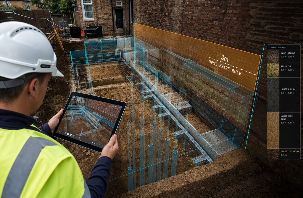
Excavation Works and the Three-Metre Rule 🏗️
One of the most technically demanding aspects of party wall practice involves excavation near neighbouring foundations. Under Section 6 of the Party Wall etc. Act 1996, a building owner must serve notice if they plan to excavate within 3 metres of a neighbouring structure where the excavation will go deeper than the neighbour's foundations, or within 6 metres where a 45-degree line from the base of the excavation would intersect the neighbour's foundations.
Understanding what the three-metre rule means in practice is essential — and BIM makes compliance demonstrably clearer. A georeferenced BIM model can:
- Visualise the exact depth and proximity of proposed excavations relative to neighbouring foundations
- Model soil behaviour using geotechnical data layers integrated into the BIM environment
- Simulate settlement risk through linked structural analysis software
- Flag notice obligations automatically when excavation parameters are entered
This is particularly relevant for basement conversions, underpinning projects, and new-build foundations in dense urban areas — all of which are surging in 2026's construction market [5]. For projects where subsidence risk is a concern, a subsidence survey can be integrated directly into the BIM workflow to provide additional geotechnical context.
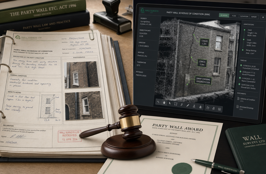
Schedules of Condition: From Photos to Point Clouds 📸➡️🔵
The schedule of condition is arguably the most important document a party wall surveyor produces. It records the pre-works state of the adjoining owner's property, forming the evidential baseline against which any damage claims are assessed.
Traditional schedules rely on:
- Digital photographs (which can be disputed for perspective and lighting)
- Written descriptions (subjective and incomplete)
- Occasional hand sketches (not to scale)
BIM-enhanced schedules of condition use 3D point cloud scanning to capture every surface, crack, and defect with spatial accuracy. Key advantages include:
- Measurable crack widths recorded to sub-millimetre precision
- 3D spatial context showing exactly where defects are located within the building fabric
- Timestamped data creating an unambiguous pre-works record
- Comparison capability — post-works scans can be overlaid on pre-works models to identify any changes objectively [2]
Research published in Energy and Buildings confirms that detailed digital building records significantly improve the accuracy of condition assessments and reduce post-project disputes [4]. For leasehold properties with schedules of condition, this level of precision is equally valuable in managing dilapidations claims.
RICS Compliance and BIM Integration in 2026 Practice
Aligning BIM with RICS Professional Standards
RICS has been clear that BIM represents a core competency for modern chartered surveyors [3]. In 2026, RICS-compliant BIM practice for party wall work involves:
- Maintaining a structured information model that documents proposed works, existing conditions, and agreed awards
- Using standardised data formats (IFC, COBie) to ensure information is accessible to all parties, including adjoining owners who may instruct their own surveyors
- Applying appropriate Levels of Detail (LOD) — typically LOD 300–400 for party wall and excavation work, ensuring geometric accuracy sufficient for legal purposes [7]
- Securing and archiving BIM data in line with GDPR and professional indemnity requirements
Surveyors who integrate BIM into their practice are not just improving technical output — they are demonstrating a professional standard that can be directly referenced in a party wall award, strengthening its legal standing.
Practical Challenges and How to Overcome Them ⚠️
BIM adoption is not without friction. Common barriers include:
| Challenge | Practical Solution |
|---|---|
| Cost of scanning equipment | Use specialist subcontractors for LiDAR surveys on a per-project basis |
| Software learning curve | RICS-accredited BIM training courses; free/low-cost tools like Autodesk BIM 360 |
| Adjoining owner reluctance | Explain BIM records protect their interests too — it documents pre-existing defects |
| Data management complexity | Adopt a simple CDE (Common Data Environment) even for small projects |
| Interoperability issues | Mandate IFC export from all consultants at project outset [8] |
The surveying profession is increasingly recognising that BIM literacy is not optional. As one industry analysis notes, surveyors who engage with BIM early are better positioned to manage complex projects, reduce errors, and deliver higher-quality professional services [2].
BIM in Dispute Resolution: Reducing Neighbour Conflicts
Why Disputes Arise — and How BIM Prevents Them
The majority of party wall disputes arise from one of three causes:
- Ambiguity about pre-existing conditions — neighbours disagree about whether damage was caused by works
- Inaccurate or incomplete party wall notices — notices that fail to describe works precisely enough
- Boundary uncertainty — disagreement about where the legal boundary sits
BIM addresses all three directly. When a party wall surveyor uses a BIM model to prepare the notice, the works are described with geometric precision — not vague language like "approximately 2 metres from the boundary." When the schedule of condition is a georeferenced point cloud, there is no room for subjective disagreement about pre-existing cracks.
The 2026 construction boom in UK housing markets has increased the frequency of party wall matters, with urban areas seeing particular pressure from basement extensions and side-return developments [5]. In this environment, the risk of disputes is higher than ever — making BIM's preventative value proportionally greater.
When Disputes Still Occur: BIM as Evidence
Even with best practice, disputes sometimes proceed to formal resolution. In these cases, BIM data becomes expert evidence. A surveyor who can present:
- A timestamped 3D point cloud of the adjoining property taken before works
- A post-works scan showing no measurable change in crack widths or structural geometry
- A BIM model confirming that excavation remained within the agreed parameters
…is in a fundamentally stronger position than one relying on a folder of photographs and handwritten notes. This is equally relevant for monitoring surveys during live construction, where real-time BIM data can confirm that agreed tolerances are being maintained throughout the works.
Implementing BIM in Your Party Wall Practice: Actionable Steps for 2026
For surveyors and building owners looking to adopt BIM-enhanced party wall practice, the following steps provide a clear pathway:
For Chartered Surveyors 🔧
- Invest in BIM Level 2 competency through RICS-accredited training before taking on complex excavation projects
- Partner with LiDAR scanning specialists to offer point-cloud schedules of condition as a standard service
- Develop a standard BIM template for party wall notices that links geometric data to legal descriptions
- Use a Common Data Environment (CDE) to share models securely with all parties, including the adjoining owner's surveyor
- Document BIM methodology in the party wall award to establish its evidential status
For Building Owners 🏠
- Request BIM-enhanced schedules of condition when appointing a party wall surveyor for excavation or boundary works
- Understand that BIM protects you too — it documents pre-existing defects in your neighbour's property, limiting spurious claims
- Ensure party wall notices are served correctly before any works begin; a failure to serve a party wall notice can expose you to significant legal and financial risk regardless of how good your BIM data is
Conclusion: The Future of Party Wall Surveying Is Digital
Building Information Modelling in Party Wall Surveys: Enhancing Accuracy for 2026 Boundary and Excavation Works is no longer a forward-looking concept — it is an active professional practice delivering measurable results. From millimetre-accurate boundary identification to point-cloud schedules of condition that withstand legal scrutiny, BIM is transforming the quality and defensibility of party wall work across the UK.
The benefits are clear: fewer disputes, stronger legal documentation, better protection for both building owners and adjoining owners, and a higher standard of RICS-compliant professional service. As the 2026 construction market continues to intensify pressure on party wall practitioners, those who embed BIM into their workflows will be better equipped to serve clients, resolve conflicts, and uphold the standards the Party Wall etc. Act 1996 demands.
✅ Actionable Next Steps
- Commission a BIM-enhanced schedule of condition before any excavation or boundary works begin
- Verify your surveyor's BIM competency — ask specifically about LiDAR scanning and point cloud capabilities
- Ensure all party wall notices precisely describe proposed works using BIM-derived geometric data
- Archive all BIM data securely for the duration of the limitation period following completion of works
- Consult a chartered surveyor experienced in both party wall law and digital surveying methods before proceeding with any notifiable works
References
[1] Bim Levels What Are They What Do They Mean – https://terrainsurveys.co.uk/news-and-media/bim-levels-what-are-they-what-do-they-mean
[2] Bim Integration For Property Surveyors Enhancing Construction Efficiency – https://manchestersurveyors.com/bim-integration-for-property-surveyors-enhancing-construction-efficiency/
[3] Building Information Modeling – https://www.ricsfirms.com/commercial/construction/building-information-modeling/
[4] S0378778826000137 – https://www.sciencedirect.com/science/article/pii/S0378778826000137
[5] Party Wall Surveys Amid 2026 Construction Boom Handling Disputes In High Demand Uk Housing Markets – https://nottinghillsurveyors.com/blog/party-wall-surveys-amid-2026-construction-boom-handling-disputes-in-high-demand-uk-housing-markets
[6] Building Information Modeling Bim And 3d Surveying Creating Precise Digital Models For Modern Construction – https://wimbledonsurveyors.com/building-information-modeling-bim-and-3d-surveying-creating-precise-digital-models-for-modern-construction/
[7] Building Information Modelling Bim In Building Surveys Competitive Advantage For Chartered Surveyors In 2026 – https://princesurveyors.co.uk/blog/building-information-modelling-bim-in-building-surveys-competitive-advantage-for-chartered-surveyors-in-2026/
[8] Chasing Bim How Surveyors Can Shape The Future – https://www.gim-international.com/content/article/chasing-bim-how-surveyors-can-shape-the-future