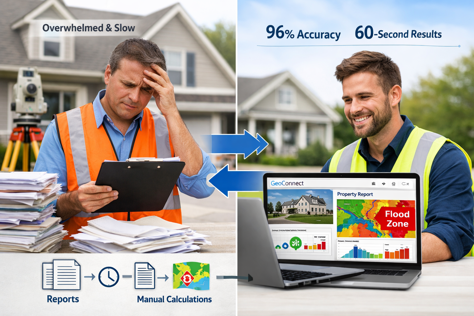
AI-powered valuation systems now achieve 96% accuracy rates, dramatically outperforming traditional manual methods that typically deliver 70-85% accuracy[4]. This isn't about replacing surveyors—it's about equipping them with integrated data platforms that transform pre-valuation assessment, reduce delays in complex cases, and support informed professional judgment. As median valuation error rates plummet to just 2.8% in 2026, down from 10-15% five years ago[5], the question is no longer whether to adopt technology-driven property insight, but how to leverage these tools effectively within professional practice.
The surveying profession stands at a critical juncture. Tools like GeoConnect and environmental data platforms enable practitioners to shift from reactive problem-solving to proactive, informed decision-making. This evolution fundamentally changes how property valuations are conducted, particularly in complex cases where traditional methods create bottlenecks and delays.
Key Takeaways
✅ AI-driven valuation tools deliver results in under 60 seconds compared to 3-5 days for traditional appraisals, enabling faster client service without compromising accuracy[1]
✅ Pricing error reduction of up to 15% is achievable through technology-augmented valuation methods compared to manual-only approaches[2]
✅ Hyper-local market forensics increase investment returns by 8-12% by tracking micro-signals like foot traffic, school ratings, and permit filings[2]
✅ Integrated data platforms support professional judgment rather than replacing it, combining algorithmic precision with surveyor expertise
✅ Environmental risk data reduces survey delays by identifying potential issues before site visits, streamlining the valuation process[6]
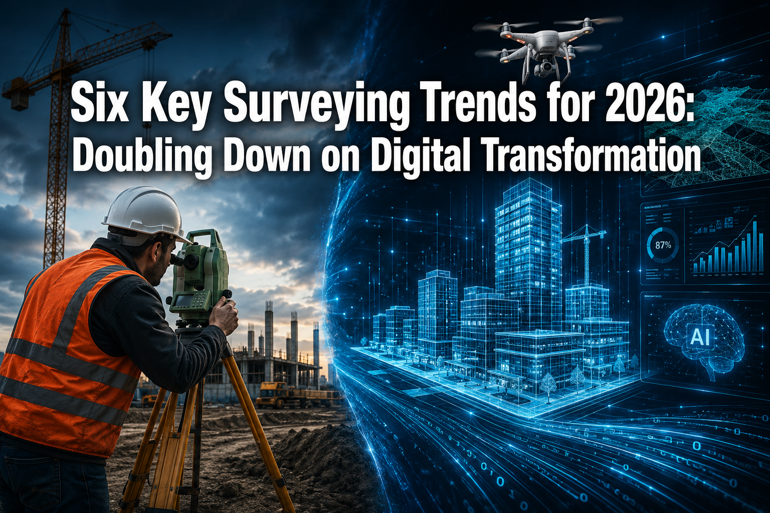
Understanding Technology-Driven Property Insight in Modern Surveying Practice
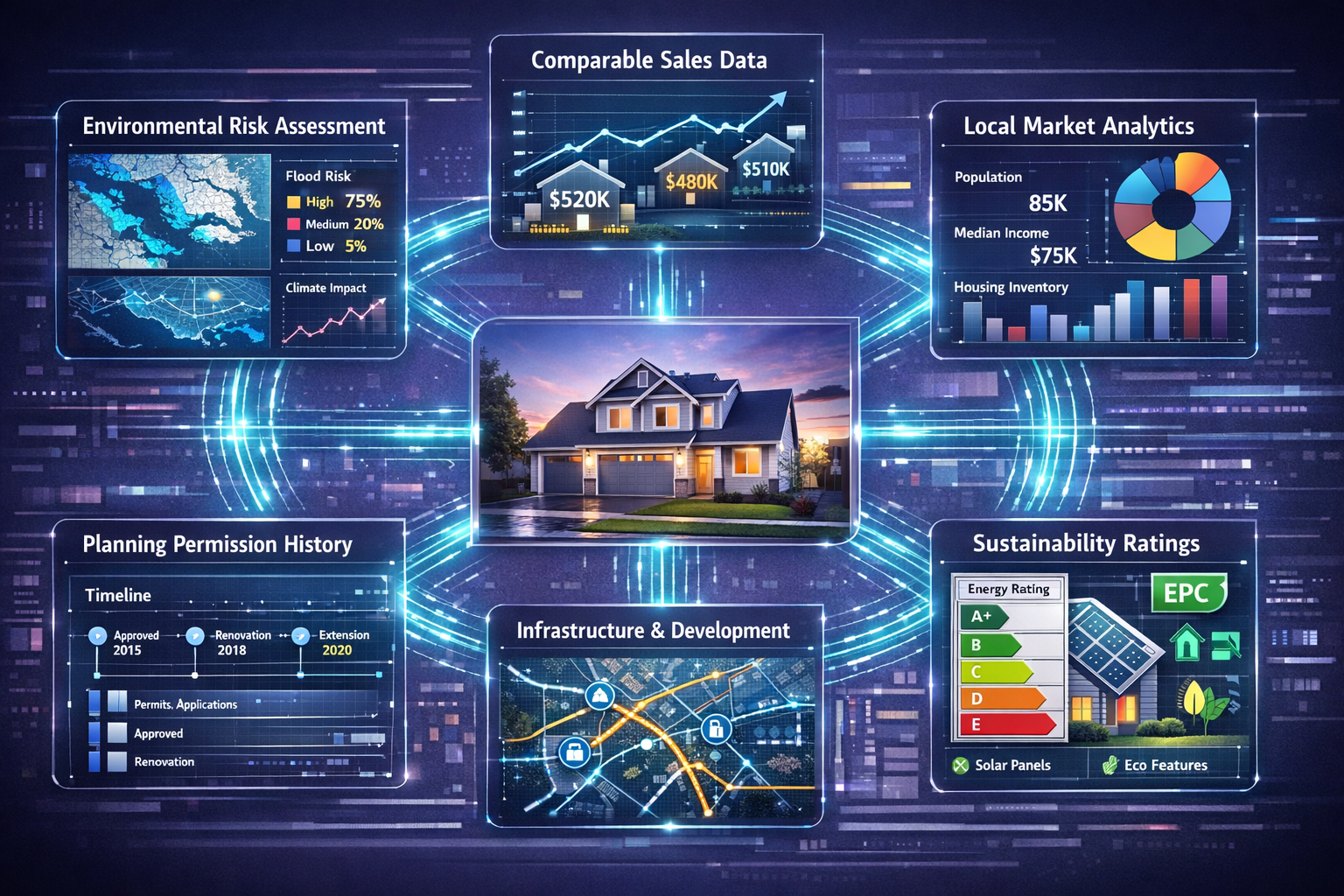
Technology-driven property insight represents a fundamental shift in how surveyors gather, analyze, and apply data throughout the valuation process. Rather than relying solely on comparable sales and physical inspections, modern practitioners integrate multiple data streams to build comprehensive property profiles before ever visiting a site.
The Data Integration Revolution
Traditional valuation methods depended heavily on manual research, local knowledge, and physical inspection. While these elements remain valuable, they're now enhanced by:
- Real-time market intelligence from automated comparable sales databases
- Environmental risk assessments including flood zones, contamination history, and climate projections
- Planning and development data showing approved applications and infrastructure projects
- Demographic and economic indicators revealing neighborhood trajectories
- Building performance metrics from energy certificates and maintenance records
This integration doesn't eliminate professional judgment—it amplifies it. Surveyors can now approach each property valuation armed with comprehensive background intelligence, focusing their expertise on interpretation rather than data collection.
Why Speed and Accuracy Matter in 2026
The property market moves faster than ever. Buyers expect rapid responses, lenders demand quick turnarounds, and investment decisions hinge on timely information. AI-driven valuation speed delivers results in under 60 seconds[1], but this isn't about replacing the surveyor's report—it's about accelerating the preliminary assessment phase.
Consider a typical commercial property valuation scenario:
| Traditional Approach | Technology-Enhanced Approach |
|---|---|
| 3-5 days for initial assessment | Under 60 seconds for preliminary data analysis |
| Manual comparable search (2-3 hours) | Automated comparable identification (instant) |
| Limited environmental data review | Comprehensive risk screening via GeoConnect |
| Sequential information gathering | Parallel data stream integration |
| Higher pricing error risk (10-15%) | Reduced error rates (2.8% median)[5] |
The technology doesn't replace the surveyor's site visit or professional analysis—it prepares them with better information, faster.
How Surveyors Should Leverage Data Tools Like GeoConnect in 2026 Valuations: Practical Implementation Strategies
GeoConnect and similar environmental data platforms represent a new category of professional tools specifically designed for surveying practice. These systems aggregate geographic, environmental, regulatory, and market data into accessible interfaces that support decision-making throughout the valuation process.
Pre-Valuation Assessment: Building the Foundation
The most significant efficiency gains come from technology-first property insight during the pre-valuation phase[6]. Before scheduling a site visit, surveyors can now:
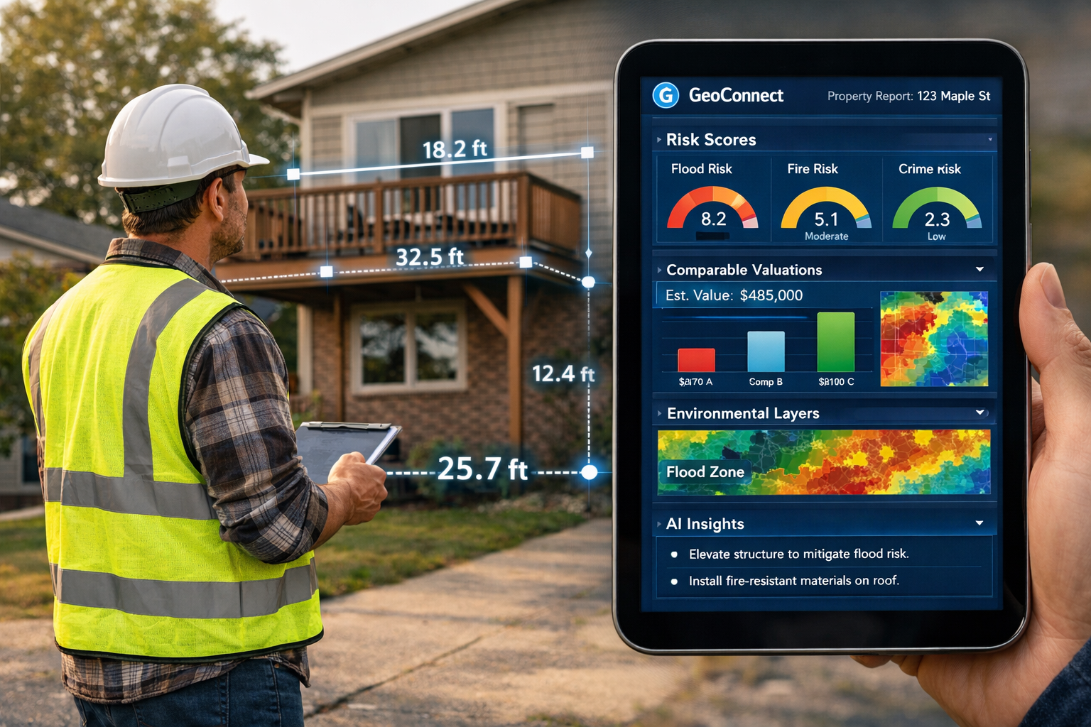
🔍 Conduct Environmental Risk Screening
GeoConnect enables instant identification of:
- Flood risk zones and historical flooding events
- Contaminated land registers and industrial site proximity
- Radon gas exposure levels
- Ground stability and subsidence risk areas
- Protected species habitats and conservation restrictions
This screening prevents surprises during physical inspections and allows surveyors to prepare appropriate investigation methods. For properties in flood-prone areas, for example, practitioners can arrange specialist assessments before completing the Red Book valuation, reducing delays and rework.
📊 Analyze Hyper-Local Market Dynamics
Beyond traditional comparable sales, modern data tools reveal micro-market signals that influence value:
- Foot traffic patterns indicating commercial viability
- School performance ratings affecting residential demand
- Crime statistics and neighborhood safety trends
- Planning application approvals showing development momentum
- Transport infrastructure investments enhancing connectivity
Research shows that hyper-local market forensics have increased investor returns by 8-12% in urban residential projects by tracking these micro-signals[2]. Surveyors who incorporate this intelligence provide clients with deeper insight beyond basic valuation figures.
🏗️ Review Planning and Development Context
Understanding a property's regulatory environment is crucial for accurate valuation. Data platforms now aggregate:
- Current and historical planning permissions
- Permitted development rights and restrictions
- Conservation area designations
- Building regulation compliance records
- Upcoming infrastructure projects affecting access or amenity
This context helps surveyors identify value-affecting factors that might not be immediately apparent during site visits, particularly important for specialist defect surveys where regulatory compliance issues can significantly impact value.
During Valuation: Augmented Professional Judgment
Technology-driven property insight doesn't replace the surveyor's site visit—it enhances what they observe and how they interpret findings. Modern practitioners use mobile-enabled data tools to:
Cross-Reference Physical Observations with Data Intelligence
When inspecting a property, surveyors can instantly verify:
- Whether visible dampness correlates with flood risk data
- If structural movement aligns with known subsidence zones
- Whether building modifications comply with planning records
- If energy efficiency claims match certificate databases
This real-time cross-referencing prevents errors and supports more confident valuations, particularly valuable during homebuyer surveys where clients rely on comprehensive risk assessment.
Apply AI-Assisted Comparable Analysis
While surveyors ultimately select and adjust comparables based on professional judgment, AI tools can:
- Identify relevant sales the surveyor might have missed
- Suggest adjustment factors based on feature differences
- Highlight market trends affecting comparable validity
- Flag outliers requiring additional scrutiny
The key is that pricing error reduction of up to 15% is achievable[2] when human expertise combines with algorithmic precision, not when either operates in isolation.
Post-Valuation: Continuous Intelligence and Monitoring
Technology-driven property insight extends beyond the initial valuation. Modern platforms enable:
📈 Ongoing Market Monitoring
For clients with property portfolios, data tools provide:
- Automated alerts when comparable sales occur
- Market trend reports showing value trajectory
- Risk factor updates (new flood maps, planning changes)
- Revaluation triggers based on market movement thresholds
This transforms the surveyor-client relationship from transactional to advisory, creating ongoing value through continuous intelligence.
🔄 Valuation Validation and Quality Assurance
Firms can use technology to:
- Benchmark individual valuations against algorithmic estimates
- Identify outliers requiring additional review
- Track accuracy over time against actual sales
- Demonstrate quality assurance to RICS standards
This doesn't mean deferring to algorithms—it means using them as a quality control layer that highlights valuations requiring additional scrutiny or documentation.
Overcoming Implementation Challenges: Technology-Driven Property Insight in Practice
Despite clear benefits, many surveying practices face obstacles when adopting technology-driven approaches. Understanding and addressing these challenges is essential for successful implementation.
Integration with Existing Workflows
The biggest implementation challenge isn't technical—it's cultural and procedural. Surveyors accustomed to traditional methods may resist changing established workflows. Successful firms address this by:
Starting with Augmentation, Not Replacement
Rather than abandoning proven methods, introduce data tools as supplements to existing practice:
- Use GeoConnect for environmental screening before site visits
- Run AI valuations as a second opinion alongside traditional analysis
- Incorporate automated comparable searches while retaining manual verification
- Apply data intelligence to inform rather than determine professional judgment
This gradual integration allows practitioners to build confidence in new tools while maintaining quality standards.
Providing Practical Training and Support
Technology adoption fails when practitioners don't understand how tools enhance their work. Effective training should:
- Demonstrate specific use cases relevant to daily practice
- Show how data tools solve actual problems surveyors face
- Provide hands-on practice with real property scenarios
- Offer ongoing support rather than one-time instruction
Firms that invest in comprehensive training see faster adoption and better outcomes.
Data Quality and Verification
Not all property data is equally reliable. Surveyors must develop skills in:
🔎 Assessing Data Source Credibility
Critical questions include:
- How frequently is the data updated?
- What is the original source (official registry vs. aggregated data)?
- How are errors corrected when identified?
- What verification processes does the platform employ?
Platforms like GeoConnect that integrate official sources (Land Registry, Environment Agency, local planning authorities) offer higher reliability than aggregated third-party databases.
⚠️ Recognizing Data Limitations
Technology-driven property insight has boundaries. Surveyors must understand:
- Algorithms can't assess property condition—physical inspection remains essential
- Historical data may not predict future trends—professional judgment interprets patterns
- Automated valuations struggle with unique properties—standard algorithms work best for typical housing stock
- Data gaps exist—rural areas and older properties may have limited digital records
The most effective practitioners combine data intelligence with traditional surveying skills, using each where it provides the most value.
Maintaining Professional Standards and Liability
Professional surveyors operate under strict regulatory frameworks, particularly RICS standards. Technology adoption must align with these requirements:
Documenting Technology Use in Valuations
When incorporating data tools into Red Book valuations, surveyors should:
- Clearly state which data sources informed the valuation
- Explain how technology-derived information was verified
- Distinguish between data-informed insights and professional judgments
- Maintain audit trails showing how conclusions were reached
This transparency protects both surveyor and client while demonstrating professional rigor.
Understanding Liability Implications
Key questions include:
- Does reliance on third-party data affect professional indemnity insurance?
- Who is liable if data platform information proves incorrect?
- How should disclaimers address technology use?
- What documentation standards apply to technology-assisted valuations?
Consulting with professional indemnity insurers and RICS guidance ensures technology adoption doesn't create unexpected liability exposure.
Cost-Benefit Analysis for Smaller Practices
Large firms can absorb technology investment costs more easily than sole practitioners or small partnerships. However, technology-driven property insight offers particular advantages for smaller practices:
💰 Competitive Differentiation
Smaller firms using advanced data tools can:
- Compete on turnaround time with larger competitors
- Offer more comprehensive risk analysis than traditional-only approaches
- Demonstrate technological sophistication to younger clients
- Provide ongoing market intelligence services beyond one-time valuations
⏱️ Efficiency Gains
Time saved through automated data gathering allows small practices to:
- Handle higher caseloads without additional staff
- Focus expertise on complex cases requiring professional judgment
- Reduce administrative overhead in research and documentation
- Improve work-life balance by eliminating tedious manual tasks
Many data platforms offer tiered pricing, making entry-level access affordable even for individual practitioners. The key is selecting tools that address specific practice needs rather than comprehensive (and expensive) enterprise solutions.
The Future of Technology-Driven Property Insight: What's Next for Surveyors
As we progress through 2026 and beyond, several trends will shape how technology-driven property insight evolves within surveying practice.
Digital Twins and Continuous Monitoring
Digital replicas of buildings enable continuous monitoring and instant valuation updates[7]. These virtual models integrate:
- Real-time sensor data from building management systems
- Maintenance records and repair history
- Energy consumption and efficiency metrics
- Occupancy patterns and space utilization
- Environmental conditions and structural performance
For commercial property surveyors, digital twins transform valuation from periodic snapshots to continuous assessment, enabling more accurate projections and risk management.
Predictive Analytics and Forward-Looking Valuations
Current technology primarily analyzes historical data. Emerging tools will increasingly:
- Project future value trajectories based on development pipelines
- Model climate change impacts on property risk profiles
- Predict maintenance requirements affecting long-term value
- Forecast neighborhood evolution based on demographic trends
This shift from retrospective to prospective analysis will require surveyors to develop new skills in interpreting predictive models while maintaining professional skepticism about algorithmic forecasts.
Integration with Broader Property Ecosystems
Technology-driven property insight will increasingly connect with:
- Conveyancing systems for seamless transaction processing
- Mortgage platforms for instant lending decisions
- Property management systems for portfolio oversight
- Planning authorities for real-time regulatory updates
Surveyors who position themselves as data-intelligent advisors within these ecosystems will find new service opportunities beyond traditional valuation work.
Sustainability and ESG Data Integration
Environmental, Social, and Governance (ESG) factors increasingly influence property values. Data tools will incorporate:
- Carbon footprint calculations and net-zero compliance
- Biodiversity impact assessments
- Social value metrics (community benefit, accessibility)
- Governance factors (ownership transparency, ethical investment)
Surveyors conducting methods of valuation analysis will need to quantify ESG impacts on value, requiring both data tools and specialized knowledge.
Conclusion: Embracing Technology-Driven Property Insight Without Losing Professional Identity
The transformation of surveying practice through technology-driven property insight represents evolution, not revolution. The core professional skills—judgment, experience, local knowledge, and ethical practice—remain as valuable as ever. What changes is how these skills are applied and enhanced through integrated data platforms like GeoConnect.
The most successful surveyors in 2026 and beyond will be those who:
✅ Embrace data tools as professional enhancers rather than viewing them as threats to traditional practice
✅ Maintain critical thinking about algorithmic outputs, understanding both their power and limitations
✅ Invest in continuous learning to stay current with evolving technology capabilities and best practices
✅ Focus expertise on interpretation and judgment while delegating data gathering to automated systems
✅ Communicate technology use transparently to clients, demonstrating how it enhances rather than replaces professional service
Actionable Next Steps for Surveyors
For Individual Practitioners:
- Audit your current workflow to identify time-consuming data gathering tasks suitable for automation
- Trial a data platform like GeoConnect with a free or entry-level subscription to assess practical value
- Attend technology-focused CPD courses to build confidence and competence with new tools
- Document technology use in your valuation reports to demonstrate enhanced methodology
For Surveying Practices:
- Conduct a technology assessment to identify gaps between current capabilities and client expectations
- Develop an integration roadmap that phases technology adoption alongside training and workflow redesign
- Establish data quality standards for evaluating and selecting technology platforms
- Create internal protocols for combining technology-derived intelligence with professional judgment
For Clients Commissioning Valuations:
- Ask surveyors about their technology use to understand how data tools enhance their service
- Request data-informed insights beyond basic valuation figures, such as risk analysis and market trends
- Value transparency in how technology and professional judgment combine in the valuation process
- Consider ongoing monitoring services that leverage continuous data intelligence
The future of surveying isn't about choosing between technology and tradition—it's about intelligently combining both to deliver superior client outcomes. Technology-driven property insight through tools like GeoConnect represents the foundation for this evolution, enabling surveyors to work smarter, faster, and more accurately while maintaining the professional standards and judgment that define the profession.
As median valuation errors continue to decline and client expectations for speed and comprehensiveness increase, the question isn't whether to adopt technology-driven approaches, but how quickly and effectively surveyors can integrate them into daily practice. Those who embrace this transformation while maintaining professional rigor will thrive in the evolving property services landscape.
References
[1] Ai Property Valuation – https://www.growthfactor.ai/resources/blog/ai-property-valuation
[2] Why 2026 Could Be The Year Ai Beats Traditional Real Estate Practices – https://www.aicerts.ai/blog/why-2026-could-be-the-year-ai-beats-traditional-real-estate-practices/
[3] Home Values 2026 Ai Green Features Redefine Worth – https://www.1percentlists.com/sell/home-values-2026-ai-green-features-redefine-worth/
[4] How Ai Is Transforming Property Valuations In 2026 – https://tkpg.co.uk/how-ai-is-transforming-property-valuations-in-2026/
[5] Ai Use Cases In Real Estate – https://www.blott.com/reports/ai-use-cases-in-real-estate
[6] Technology First Property Insight Using Geoconnect And Environmental Data To Reduce Building Survey Delays In 2026 – https://nottinghillsurveyors.com/blog/technology-first-property-insight-using-geoconnect-and-environmental-data-to-reduce-building-survey-delays-in-2026
[7] Technology For Early Property Insight In 2026 Building Surveys Reducing Delays In Complex Valuations – https://nottinghillsurveyors.com/blog/technology-for-early-property-insight-in-2026-building-surveys-reducing-delays-in-complex-valuations