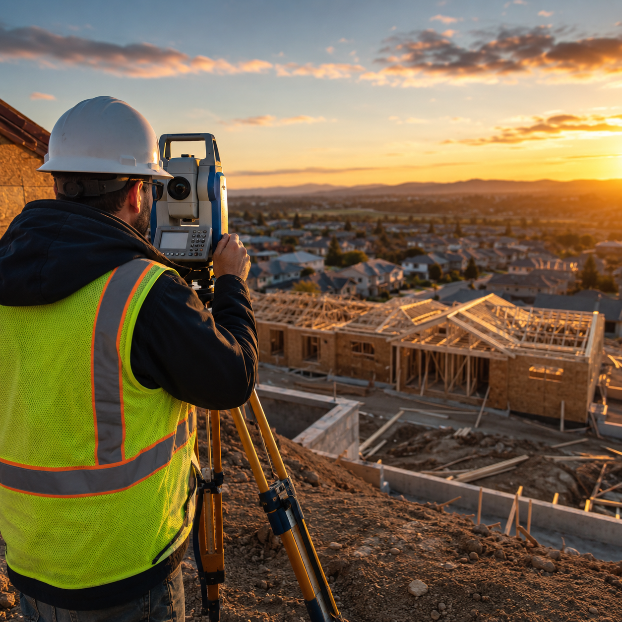
The property surveying landscape is experiencing a revolutionary transformation in 2026. Autonomous Drones and Multi-Sensor Tech: Transforming Property Surveys for Agriculture and Development in 2026 represents more than just technological advancement—it signals a fundamental shift in how professionals capture, analyze, and leverage spatial data. Where traditional surveying methods once required weeks of fieldwork, multiple site visits, and extensive manual measurements, today's autonomous drone systems complete comprehensive property assessments in single flights, delivering unprecedented accuracy at a fraction of the cost.
This transformation is particularly evident in agriculture and development sectors, where the demand for precise, timely data has never been higher. The integration of multispectral imaging, thermal sensors, and artificial intelligence-driven analytics enables surveyors to extract insights that were previously impossible or prohibitively expensive to obtain. For commercial clients, this means faster project timelines, reduced operational costs, and data-driven decision-making capabilities that provide competitive advantages in increasingly complex markets.
Key Takeaways
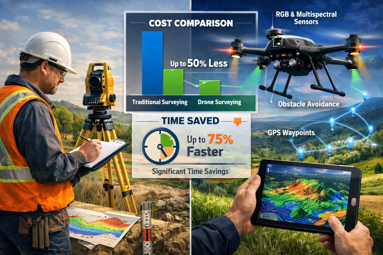
🚁 Single-Flight Efficiency: Modern autonomous drones equipped with multi-sensor arrays can capture comprehensive property data in one flight, reducing survey time by up to 75% compared to traditional ground-based methods.
💰 Significant Cost Savings: The Agriculture Drones Market, valued at USD 4.41 billion in 2026, demonstrates the economic viability of drone technology, with commercial clients reporting 40-60% cost reductions on large-scale property surveys[2].
📊 Enhanced Data Quality: Advanced sensors achieve 1.2 cm ground resolution at 60 meters altitude, providing detail levels that exceed traditional surveying capabilities while simultaneously capturing thermal, multispectral, and RGB data[1][3].
🤖 Predictive Analytics Integration: AI-driven analysis of drone-captured data enables predictive modeling for crop yields, irrigation optimization, and development site planning, transforming raw imagery into actionable intelligence.
🌍 Regulatory Support Expansion: Evolving regulations for beyond-visual-line-of-sight (BVLOS) operations are opening new possibilities for autonomous surveying across larger properties and remote locations[1].
Understanding the Shift: Traditional Surveying Methods vs. Autonomous Drone Technology
The surveying profession has relied on established methodologies for decades. Traditional approaches involve ground-based measurements using theodolites, total stations, and GPS equipment. Surveyors physically traverse properties, establishing control points, measuring distances, and manually documenting features. For agricultural properties, this process includes walking fields, taking soil samples at discrete locations, and conducting visual crop assessments. Development sites require similar intensive fieldwork, with surveyors establishing elevation benchmarks and boundary markers through time-consuming manual processes.
These conventional methods, while accurate, present significant limitations. Time requirements for large properties can extend to weeks or months. Labor costs accumulate rapidly, particularly for properties requiring multiple visits across growing seasons or construction phases. Data density remains limited to sampled points rather than comprehensive coverage, potentially missing critical variations between measurement locations. Weather dependencies and accessibility challenges further complicate traditional surveying timelines.
The Autonomous Drone Revolution
Autonomous Drones and Multi-Sensor Tech: Transforming Property Surveys for Agriculture and Development in 2026 addresses these limitations through integrated technological solutions. Modern drone surveys leverage several key capabilities:
Autonomous Flight Systems: RTK/GPS-enabled drones execute pre-planned flight paths with centimeter-level positioning accuracy. Operators program survey parameters—altitude, overlap percentages, sensor configurations—and the drone executes the mission independently. Obstacle avoidance systems using LiDAR and computer vision ensure safe operation even in complex environments with trees, structures, or terrain variations[4].
Multi-Sensor Integration: Single platforms simultaneously capture data from multiple sensors:
- RGB cameras provide high-resolution visual documentation
- Multispectral sensors measure plant health through NDVI and other vegetation indices
- Thermal imaging reveals temperature variations for irrigation assessment and livestock monitoring
- LiDAR systems generate precise elevation models even through vegetation canopy
Real-Time Processing: Advanced drones process sensor data during flight, enabling operators to verify coverage quality and identify areas requiring additional passes before leaving the site. This single-flight capture capability eliminates the need for return visits due to data gaps or quality issues.
Comparative Performance Metrics
The performance differences between traditional and autonomous drone surveying are substantial:
| Metric | Traditional Methods | Autonomous Drone Systems | Improvement |
|---|---|---|---|
| Survey Time (100 hectares) | 5-7 days | 4-6 hours | 75-85% reduction |
| Ground Resolution | 10-50 cm | 1.2 cm | 8-40x improvement[1][3] |
| Data Points Captured | 500-2,000 | 50,000-500,000+ | 100-250x increase |
| Cost per Hectare | £150-300 | £40-80 | 60-75% savings |
| Weather Dependency | High | Moderate | Greater flexibility |
| Repeat Visit Requirements | 3-5 per season | 1-2 per season | 50-60% reduction |
These improvements translate directly to commercial value. A development company planning a 200-hectare mixed-use project can complete initial site surveys in two days rather than three weeks, accelerating project timelines and reducing holding costs. Agricultural operations monitoring crop health across 500 hectares can conduct weekly assessments at costs previously associated with monthly evaluations, enabling proactive intervention before problems escalate.
Cost-Benefit Analysis for Commercial Clients
The economic case for autonomous drone surveying extends beyond direct cost comparisons. Total cost of ownership considerations include:
Initial Investment: Professional-grade autonomous drone systems with multi-sensor capabilities range from £25,000-£75,000 depending on specifications. For surveying firms conducting regular assessments, this investment typically achieves payback within 12-18 months through increased project capacity and reduced labor requirements.
Operational Efficiency: Autonomous systems reduce field crew requirements from 3-4 personnel to 1-2 operators. The time savings enable firms to complete more projects annually with existing staff, increasing revenue potential without proportional cost increases.
Data Value Enhancement: The comprehensive datasets generated by multi-sensor drones support additional service offerings. Agricultural clients receive not just boundary surveys but also crop health analysis, irrigation optimization recommendations, and yield predictions. Development clients obtain topographic models, volumetric calculations, and progress monitoring—all from the same data capture mission.
Risk Reduction: High-resolution documentation provides defensible records for commercial building surveys and insurance assessments. The ability to revisit historical drone imagery resolves disputes about pre-existing conditions or project progress without costly site revisits.
Advanced Multi-Sensor Technologies Driving Agricultural Transformation
The agricultural sector represents the largest application area for Autonomous Drones and Multi-Sensor Tech: Transforming Property Surveys for Agriculture and Development in 2026, with the market projected to reach USD 11.79 billion by 2030 at a 27.9% compound annual growth rate[2]. This explosive growth reflects the technology's ability to address critical agricultural challenges through precision data capture and analysis.
Multispectral and Hyperspectral Imaging Systems
Multispectral sensors capture light across multiple specific wavelength bands, revealing information invisible to human vision or standard RGB cameras. Agricultural drones typically deploy sensors measuring:
- Green band (530-570 nm): Indicates overall plant vigor
- Red band (640-680 nm): Sensitive to chlorophyll absorption
- Red-edge band (690-730 nm): Detects early stress before visible symptoms
- Near-infrared band (760-850 nm): Reflects strongly from healthy vegetation
The Parrot Bluegrass quadcopter exemplifies this technology, integrating a Sequoia multispectral sensor that covers approximately 30 hectares per battery flight at 70-meter altitude[4]. The system captures data across all four bands simultaneously, enabling real-time NDVI calculation during flight.
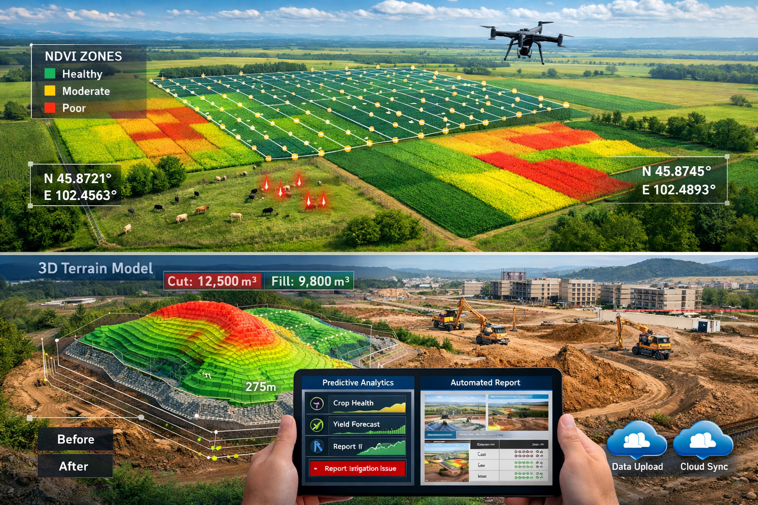
Normalized Difference Vegetation Index (NDVI) represents the most widely used vegetation health metric, calculated as:
NDVI = (NIR – Red) / (NIR + Red)
Healthy, actively growing vegetation shows high NDVI values (0.7-0.9) due to strong near-infrared reflection and red light absorption during photosynthesis. Stressed plants exhibit lower values (0.3-0.5) as chlorophyll production decreases and red absorption weakens. This quantitative assessment enables farmers to identify problem areas weeks before visual symptoms appear, allowing targeted interventions that prevent yield losses.
Hyperspectral systems extend this concept further, capturing data across hundreds of narrow spectral bands. While more expensive and data-intensive, hyperspectral sensors detect subtle variations indicating specific nutrient deficiencies, disease types, or pest damage. Research applications use hyperspectral data to develop predictive models for yield forecasting and quality assessment.
Thermal Imaging for Irrigation and Livestock Management
Thermal sensors measure infrared radiation emitted by objects, revealing temperature variations that indicate water stress, irrigation system failures, or livestock health issues. University of Arizona field tests demonstrate that canopy temperature mapping effectively distinguishes well-irrigated versus water-stressed crop areas, with stressed plants showing 3-7°C higher temperatures due to reduced evaporative cooling[4].
Practical applications include:
Irrigation System Verification: Thermal imagery reveals blocked sprinkler heads, broken irrigation lines, and uneven water distribution patterns. A single drone flight identifies problems across entire fields that would require days to detect through ground inspection.
Water Stress Mapping: By correlating thermal data with multispectral vegetation indices, agronomists create soil moisture stress zone maps that guide variable-rate irrigation programming. This precision approach reduces water consumption by 15-30% while maintaining or improving yields.
Livestock Monitoring: Ranchers deploy thermal-enabled drones like the Raptor and ANAFI models for livestock detection, missing animal recovery, and health assessment[4]. Thermal imaging detects heat stress patterns in cattle, enabling timely intervention during extreme weather. The technology also monitors grazing compliance in rotational grazing systems, verifying that animals have moved to designated pastures.
RGB and LiDAR Integration for Comprehensive Property Assessment
While specialized sensors capture specific data types, high-resolution RGB cameras remain essential for visual documentation and photogrammetric modeling. Modern agricultural drones achieve 1.2 cm full-color ground resolution at 60 meters altitude[1][3], providing detail sufficient for individual plant counting, weed identification, and infrastructure inspection.
LiDAR (Light Detection and Ranging) systems complement optical sensors by directly measuring distances using laser pulses. LiDAR penetrates vegetation canopy, enabling accurate ground elevation modeling even in dense crops or forested areas. This capability proves invaluable for:
- Drainage planning: Identifying subtle elevation variations that affect water flow
- Erosion assessment: Detecting soil loss patterns through repeat surveys
- Canopy height modeling: Calculating biomass and predicting yields
- Infrastructure planning: Generating precise terrain models for irrigation system design
The combination of RGB photogrammetry and LiDAR data produces comprehensive 3D models with both visual detail and geometric accuracy, supporting applications from drainage surveys to precision agriculture planning.
Predictive Modeling and AI-Driven Analytics
The true transformation in Autonomous Drones and Multi-Sensor Tech: Transforming Property Surveys for Agriculture and Development in 2026 extends beyond data capture to intelligent analysis. AI-driven analytics platforms process multi-sensor drone data to generate actionable insights:
Crop Health Prediction Models: Machine learning algorithms trained on historical drone imagery, weather data, and yield records predict crop performance weeks in advance. These models identify fields or zones requiring intervention, prioritizing management attention where it delivers maximum return.
Disease and Pest Detection: Computer vision systems analyze RGB and multispectral imagery to detect disease symptoms or pest damage patterns. Early detection enables targeted treatment of affected areas rather than blanket field applications, reducing chemical costs and environmental impact.
Yield Forecasting: Integration of multispectral vegetation indices, canopy height models from LiDAR, and historical performance data generates field-specific yield predictions. These forecasts support marketing decisions, harvest logistics planning, and crop insurance documentation.
Variable Rate Application Mapping: Analysis platforms convert drone-captured data into prescription maps for variable-rate equipment. Fertilizer, pesticide, and irrigation applications adjust automatically based on within-field variability, optimizing inputs and reducing waste.
Leading Agricultural Drone Platforms in 2026
Several platforms dominate the agricultural surveying market, each optimized for specific applications:
Fixed-Wing Mapping Drones excel at large-area coverage:
-
WingtraOne Gen II: VTOL design combines vertical takeoff convenience with 59-minute flight endurance. The 800g sensor payload accommodates professional multispectral and RGB cameras, making it ideal for surveys exceeding 100 hectares[4].
-
AgEagle eBee X: USA-manufactured platform emphasizes regulatory compliance and data security. Flight times approaching 90 minutes enable coverage of 200+ hectares per flight with appropriate sensors.
-
Trinity Pro: German-engineered system prioritizes precision, with RTK/PPK positioning delivering 2-3 cm absolute accuracy for applications requiring survey-grade results.
Multispectral Rotary Platforms provide flexibility for smaller properties and detailed assessments:
-
Parrot Bluegrass: Integrated Sequoia sensor and user-friendly operation make this platform accessible for farm-level deployment. The ~30 hectare per flight coverage suits most individual field assessments[4].
-
DJI Agras T40: While primarily designed for precision spraying, the platform's multispectral capabilities and obstacle avoidance systems enable dual-purpose deployment for both surveying and application.
The selection between platforms depends on property size, required data types, and operational constraints. Large-scale operations managing thousands of hectares favor fixed-wing efficiency, while diverse farms with multiple smaller fields benefit from rotary platform versatility.
Development and Construction Applications: Beyond Agriculture
While agricultural applications drive market growth, Autonomous Drones and Multi-Sensor Tech: Transforming Property Surveys for Agriculture and Development in 2026 delivers equally transformative benefits for development and construction sectors. The technology addresses critical challenges in site assessment, project monitoring, and compliance documentation.
Pre-Development Site Assessment and Planning
Development projects begin with comprehensive site understanding. Traditional surveying provides boundary definitions and topographic information, but multi-sensor drone surveys deliver enhanced intelligence:
Topographic Modeling: Photogrammetric processing of overlapping RGB images generates detailed Digital Elevation Models (DEMs) and Digital Surface Models (DSMs). These models reveal elevation variations, slope percentages, and drainage patterns essential for site planning. LiDAR integration improves accuracy in vegetated areas, ensuring reliable data for engineering calculations.
Vegetation and Environmental Assessment: Multispectral sensors identify vegetation types, health, and density across development sites. This information supports environmental impact assessments, tree preservation planning, and habitat mitigation strategies. Thermal imaging detects water features, wetlands, and drainage patterns that may not be visible in standard photography.
Infrastructure Proximity Analysis: High-resolution RGB imagery documents existing structures, utilities, and access routes surrounding development sites. The comprehensive visual record supports planning decisions and provides baseline documentation for schedule of condition reports on adjacent properties.
Volumetric Calculations: Drone-generated 3D models enable precise calculation of cut-and-fill volumes for site grading. Developers obtain accurate earthwork estimates before committing to projects, reducing budget uncertainties and supporting competitive bidding processes.
Construction Progress Monitoring and Documentation
Active construction sites present ideal applications for autonomous drone technology. Regular flights document progress, verify contractor performance, and provide stakeholders with current project status:
Automated Progress Tracking: Drones flying identical paths at regular intervals (weekly, monthly) capture consistent imagery for progress comparison. Software platforms automatically detect changes between flights, quantifying completed work and identifying schedule deviations.
Quality Assurance: High-resolution imagery reveals construction quality issues—improper grading, material placement errors, or workmanship defects—before they become costly problems. Early detection enables corrective action while contractors remain on-site and responsible parties are clearly identified.
Safety Compliance Monitoring: Aerial perspectives reveal safety hazards that ground-level inspections miss. Unsecured materials, improper scaffolding, or dangerous site conditions become evident in drone imagery, supporting proactive safety management.
Stakeholder Communication: Visual documentation from drone surveys provides compelling progress updates for investors, lenders, and regulatory authorities. The ability to demonstrate tangible progress supports draw requests and maintains stakeholder confidence.
As-Built Documentation: Final construction surveys capture completed projects for as-built records, facility management systems, and warranty documentation. The comprehensive visual and geometric data supports future maintenance planning and modification projects.
Regulatory Compliance and Beyond-Visual-Line-of-Sight Operations
The expansion of Autonomous Drones and Multi-Sensor Tech: Transforming Property Surveys for Agriculture and Development in 2026 depends significantly on regulatory evolution. Current regulations in most jurisdictions require drone operators to maintain visual line of sight (VLOS) with aircraft during flight. This limitation restricts operational range and necessitates multiple takeoff/landing locations for large properties.
Beyond-Visual-Line-of-Sight (BVLOS) operations represent the next frontier in autonomous surveying. Regulatory authorities are developing frameworks that permit BVLOS flights under specific conditions:
- Detect-and-avoid technology: Onboard sensors and AI systems detect and avoid other aircraft, obstacles, and hazards without pilot intervention
- Command and control links: Redundant communication systems ensure reliable aircraft control even at extended ranges
- Flight corridor restrictions: BVLOS operations may initially be limited to designated airspace or rural areas with minimal air traffic
- Operational approvals: Case-by-case authorization processes verify operator competence and system reliability
The regulatory support for expanded drone use, particularly for autonomous operations, is strengthening in 2026[1]. This evolution enables surveyors to assess properties exceeding 1,000 hectares from single launch points, dramatically improving efficiency and reducing operational costs.
Integration with Traditional Surveying Services
Autonomous drone technology complements rather than replaces traditional surveying expertise. Professional surveyors integrate drone-captured data with established methodologies to deliver comprehensive services:
Ground Control Point Establishment: Survey-grade accuracy requires establishing ground control points (GCPs) using traditional GPS equipment. These precisely measured reference locations enable photogrammetric processing to achieve absolute positional accuracy matching or exceeding traditional survey standards.
Boundary Verification: While drones excel at capturing physical features, legal boundary determination requires professional surveyor interpretation of title documents, historical records, and regulatory requirements. Local chartered surveyors combine drone-captured data with legal expertise to deliver defensible boundary surveys.
Specialized Assessments: Complex situations—subsidence surveys, structural defect investigations, or dilapidation surveys—benefit from drone data but require professional interpretation and supplementary ground-based investigation. The technology provides comprehensive documentation that enhances rather than replaces professional judgment.
Hybrid Service Delivery: Forward-thinking surveying firms offer integrated services combining autonomous drone data capture with traditional expertise. Clients receive comprehensive assessments faster and more cost-effectively than either approach could deliver independently.
Real-World Applications and Case Studies: Demonstrating Value Across Sectors
The practical benefits of Autonomous Drones and Multi-Sensor Tech: Transforming Property Surveys for Agriculture and Development in 2026 become clear through real-world applications across diverse sectors. These examples demonstrate how commercial clients achieve measurable returns on technology investment.
Large-Scale Agricultural Operations: Precision at Scale
A 2,500-hectare grain operation in East Anglia implemented autonomous drone surveying in 2025, deploying a WingtraOne Gen II with multispectral capabilities. The operation previously conducted manual crop scouting on a two-week rotation, requiring three full-time staff and providing limited coverage of the extensive property.
Implementation Approach: The farm established a weekly flight schedule covering the entire operation in four autonomous missions. Each flight captured RGB and multispectral data processed through cloud-based analytics platforms generating NDVI maps, crop health assessments, and variable-rate application prescriptions.
Measured Results:
- Labor reduction: Crop scouting staff reduced from three to one drone operator
- Problem detection: Disease outbreaks identified 12-14 days earlier than visual scouting
- Input optimization: Variable-rate nitrogen application reduced fertilizer costs by 18% while maintaining yields
- Yield improvement: Early problem detection and targeted intervention increased average yields by 7%
- ROI: Total system cost (£68,000) achieved payback in 14 months through combined labor savings and production improvements
The operation now uses historical drone data to develop field-specific management strategies, identifying consistently underperforming zones for detailed soil analysis and remediation.
Development Site Monitoring: Accelerating Project Timelines
A 45-hectare mixed-use development project in the Home Counties required monthly progress monitoring for lender compliance and contractor management. Traditional surveying approaches involved two-day site visits by three-person crews, generating reports 5-7 days after fieldwork completion.
Implementation Approach: The developer engaged a surveying firm offering drone survey services with autonomous capabilities. Monthly flights captured RGB imagery and LiDAR data, processed into 3D models showing construction progress, volumetric calculations, and deviation analysis against project plans.
Measured Results:
- Survey time: Reduced from two days to four hours including setup and flight operations
- Report delivery: Automated processing delivered preliminary reports within 24 hours of flight
- Cost savings: Monthly monitoring costs decreased by 62% compared to traditional approaches
- Issue detection: Grading errors identified and corrected before subsequent construction phases, avoiding £180,000 in potential rework costs
- Stakeholder confidence: Visual progress documentation supported draw requests and maintained investor engagement
The developer now requires drone-based progress monitoring as standard practice on all projects exceeding 10 hectares, recognizing the technology as essential risk management infrastructure.
Livestock Ranch Management: Thermal Technology in Practice
A 1,200-hectare cattle ranch in Scotland adopted thermal-equipped autonomous drones for livestock monitoring and pasture management. The operation previously relied on horseback and ATV patrols requiring 6-8 hours daily to verify animal locations, health status, and grazing compliance.
Implementation Approach: Daily autonomous flights using thermal imaging covered designated pasture areas, with AI-powered software automatically detecting and counting cattle. The system flagged animals separated from herds, identified heat stress patterns during warm periods, and verified rotational grazing compliance.
Measured Results:
- Labor efficiency: Daily monitoring time reduced from 6-8 hours to 45 minutes (flight + review)
- Animal recovery: Missing animals located 75% faster using thermal detection
- Health intervention: Heat stress detection enabled proactive cooling measures, reducing summer mortality by 40%
- Grazing optimization: Verified compliance with rotational grazing schedules improved pasture recovery and carrying capacity
- ROI: System cost (£32,000) offset by labor savings and reduced livestock losses within 11 months
The ranch expanded drone deployment to include multispectral pasture health monitoring, using vegetation indices to optimize grazing rotation timing and identify areas requiring reseeding or fertilization.
Insurance Assessment and Crop Damage Documentation
Drone technology increasingly supports crop damage insurance assessments, providing objective, high-resolution documentation for claim validation[2]. An agricultural insurance provider piloted autonomous drone assessment for hail damage claims across multiple farms.
Implementation Approach: Following hail events, the insurer deployed drone teams within 24-48 hours to capture comprehensive imagery of affected fields. Multispectral and RGB data documented damage extent, severity, and spatial distribution. AI analysis compared pre- and post-event imagery to quantify damage objectively.
Measured Results:
- Assessment speed: Claim documentation time reduced from 5-7 days to 1-2 days per claim
- Accuracy improvement: Objective quantification reduced disputes and enabled faster claim settlement
- Cost reduction: Assessment costs decreased by 55% compared to traditional manual field inspection
- Fraud detection: Comprehensive coverage revealed inconsistencies in some claims, reducing fraudulent payments
- Customer satisfaction: Faster processing and objective documentation improved policyholder experience
The insurer now offers premium discounts to farms agreeing to drone-based assessment protocols, recognizing the mutual benefits of faster, more accurate claim processing.
Selecting the Right Technology: Decision Framework for Commercial Clients
Organizations considering Autonomous Drones and Multi-Sensor Tech: Transforming Property Surveys for Agriculture and Development in 2026 face numerous technology options and implementation approaches. A structured decision framework ensures investments align with operational requirements and deliver expected returns.
Defining Survey Requirements and Objectives
Successful technology selection begins with clear requirement definition:
Property Characteristics:
- Size: Properties under 50 hectares suit rotary platforms; larger areas favor fixed-wing efficiency
- Terrain: Complex topography or obstacles may require advanced obstacle avoidance systems
- Vegetation: Dense canopy necessitates LiDAR for accurate ground elevation modeling
- Access: Remote locations benefit from extended flight endurance platforms
Data Requirements:
- Resolution needs: Determine minimum ground sample distance (GSD) for intended applications
- Sensor types: Identify essential sensors (RGB, multispectral, thermal, LiDAR) based on analysis objectives
- Update frequency: Regular monitoring requires efficient, repeatable autonomous flight capabilities
- Accuracy standards: Survey-grade applications demand RTK/PPK positioning and proper ground control
Operational Constraints:
- Regulatory environment: Verify operational approvals and restrictions in target locations
- Weather sensitivity: Consider climate patterns and acceptable operational weather limits
- Personnel expertise: Assess available operator skills and training requirements
- Budget parameters: Define total cost of ownership including hardware, software, training, and ongoing operations
Platform Selection: Fixed-Wing vs. Rotary Systems
The fundamental platform choice significantly impacts operational capabilities and costs:
Fixed-Wing Advantages:
- Extended flight endurance (45-90+ minutes) enables large-area coverage
- Higher cruise speeds reduce survey time for extensive properties
- Better wind tolerance maintains operations in challenging conditions
- Lower per-hectare operating costs for large-scale applications
Fixed-Wing Limitations:
- Requires launch and landing space (VTOL models mitigate this constraint)
- Less maneuverable for detailed inspection of specific features
- Higher initial investment costs (£25,000-£75,000+ for professional systems)
- Steeper learning curve for operation and maintenance
Rotary Platform Advantages:
- Vertical takeoff/landing operates from confined spaces
- Excellent maneuverability for detailed feature inspection
- Hovering capability enables precise positioning for specialized imaging
- Generally lower acquisition costs (£15,000-£45,000 for professional systems)
- Easier operation and faster pilot training
Rotary Platform Limitations:
- Shorter flight endurance (20-35 minutes typical) limits coverage area
- Higher per-hectare operating costs due to battery changes and reduced efficiency
- Greater weather sensitivity, particularly to wind
- Multiple flights required for large properties increase operational complexity
Hybrid VTOL Solutions increasingly dominate professional applications, combining vertical takeoff convenience with fixed-wing efficiency. The WingtraOne Gen II exemplifies this approach, offering 59-minute endurance with no launch/landing infrastructure requirements[4]. While commanding premium pricing, hybrid platforms deliver operational flexibility that justifies investment for diverse surveying applications.
Sensor Configuration and Integration
Multi-sensor capability defines modern surveying drones, but optimal configurations vary by application:
Agricultural Applications prioritize:
- Multispectral sensors (minimum 4-band: green, red, red-edge, NIR) for vegetation analysis
- Thermal imaging for irrigation assessment and livestock monitoring
- High-resolution RGB (minimum 20MP) for visual documentation and photogrammetry
- Optional LiDAR for canopy height modeling and precision terrain mapping
Development and Construction Applications emphasize:
- High-resolution RGB (minimum 42MP) for detailed visual documentation
- LiDAR for accurate terrain modeling and volumetric calculations
- Optional thermal for building envelope inspection and moisture detection
- Optional multispectral for vegetation assessment and environmental monitoring
Integrated Sensor Platforms simplify operations by mounting multiple sensors on single aircraft, enabling simultaneous data capture. The Parrot Bluegrass combines RGB video and Sequoia multispectral sensors in a unified package[4]. While convenient, integrated platforms offer less flexibility than modular systems allowing sensor swapping based on mission requirements.
Modular Sensor Approaches use interchangeable payloads on common airframes. Professional platforms like the WingtraOne Gen II accommodate various sensors within the 800g payload capacity, enabling organizations to expand capabilities over time without replacing entire systems[4].
Software and Analytics Platforms
Drone hardware captures data, but software platforms transform raw imagery into actionable intelligence. Evaluation criteria include:
Processing Capabilities:
- Photogrammetric processing: Generates orthomosaics, DEMs, DSMs, and 3D models from overlapping imagery
- Multispectral analysis: Calculates vegetation indices (NDVI, NDRE, GNDVI) and generates health maps
- Thermal processing: Converts thermal imagery into temperature maps and stress zone identification
- LiDAR processing: Generates point clouds, classified terrain models, and canopy height models
AI and Analytics Features:
- Automated feature detection: Identifies plants, structures, defects, or changes without manual interpretation
- Predictive modeling: Forecasts yields, identifies developing problems, or projects construction timelines
- Change detection: Automatically compares multi-temporal datasets to quantify changes
- Prescription generation: Creates variable-rate application maps for precision agriculture equipment
Workflow Integration:
- Cloud processing: Enables automated processing without local computing infrastructure investment
- Mobile access: Supports field review and decision-making through tablet/smartphone applications
- Data export: Provides outputs compatible with GIS, CAD, farm management, and construction software
- Reporting automation: Generates standardized reports reducing manual documentation time
Leading Platforms in 2026 include:
- Pix4D: Comprehensive photogrammetric processing with agricultural and construction-specific modules
- DroneDeploy: Cloud-based platform emphasizing ease of use and automated workflows
- Agisoft Metashape: Professional photogrammetry with extensive control over processing parameters
- Sentera: Agricultural focus with advanced vegetation analysis and prescription generation
- Propeller: Construction and earthwork specialization with volumetric analysis and progress tracking
Platform selection should align with primary applications, technical expertise, and budget considerations. Many organizations begin with user-friendly cloud platforms, transitioning to more sophisticated solutions as capabilities mature.
Build vs. Buy vs. Service Provider: Implementation Models
Organizations implement drone surveying through various models:
Internal Capability Development (Buy):
- Advantages: Complete control over scheduling, data ownership, and operational priorities; long-term cost efficiency for frequent surveys
- Disadvantages: Significant upfront investment (£40,000-£100,000+ for complete systems); ongoing training, maintenance, and regulatory compliance requirements
- Best for: Organizations conducting surveys monthly or more frequently across multiple properties
Service Provider Engagement (Outsource):
- Advantages: No capital investment; access to latest technology and expert operators; flexible capacity scaling
- Disadvantages: Higher per-survey costs; scheduling dependencies; potential data security concerns
- Best for: Organizations with occasional survey needs or exploring technology before committing to internal development
Hybrid Approaches:
- Equipment rental: Short-term access to specific platforms for project-based needs
- Operator training with equipment purchase: Combines hardware investment with expert training and initial operational support
- Partnership models: Shared ownership or cooperative arrangements among multiple organizations
The optimal approach depends on survey frequency, budget availability, and strategic importance of surveying capabilities. Many organizations begin with service providers, transition to equipment rental for specific projects, and ultimately develop internal capabilities as requirements and expertise grow.
For those seeking professional expertise, engaging local chartered surveyors with drone capabilities provides access to technology and interpretation expertise without capital investment.
Future Developments and Emerging Trends in Autonomous Survey Technology
Autonomous Drones and Multi-Sensor Tech: Transforming Property Surveys for Agriculture and Development in 2026 represents current state-of-the-art, but rapid technological advancement continues reshaping capabilities and applications. Understanding emerging trends enables organizations to make future-proof investment decisions.
Swarm Technology and Coordinated Multi-Drone Operations
Swarm technologies enable multiple drones to operate cooperatively under coordinated control. Rather than flying sequential missions, drone swarms survey large properties simultaneously, dramatically reducing total survey time. Advanced algorithms distribute survey areas among swarm members, optimize flight paths to minimize redundancy, and coordinate data capture to ensure comprehensive coverage[2].
Practical applications emerging in 2026 include:
- Rapid response assessment: Deploying 5-10 drones simultaneously to document storm damage, flooding, or other time-sensitive conditions across extensive areas
- Real-time monitoring: Continuous surveillance of active construction sites or critical agricultural periods using rotating drone coverage
- Multi-perspective capture: Simultaneous imaging from multiple angles improves 3D reconstruction quality and reduces processing time
Regulatory frameworks are evolving to accommodate swarm operations, with initial approvals focusing on rural areas and controlled airspace. As regulatory acceptance grows, swarm technology will become standard practice for large-scale surveying applications.
Enhanced AI Capabilities and Edge Processing
Current AI analytics primarily operate in cloud platforms, processing drone data after flights complete. Edge computing brings AI processing directly to drone platforms, enabling real-time analysis during flight. This advancement supports:
Adaptive Mission Planning: Drones analyze data during flight, identifying areas requiring additional detail or different sensor configurations. The system automatically adjusts flight parameters or triggers return flights with appropriate sensors, ensuring comprehensive data capture without manual intervention.
Intelligent Feature Tracking: AI systems detect and track specific features—individual plants, livestock, construction equipment, or infrastructure elements—across multiple flights. This temporal tracking reveals growth patterns, movement behaviors, or progress trends without manual data correlation.
Anomaly Detection and Alerting: Real-time analysis identifies unexpected conditions—crop disease outbreaks, construction defects, or safety hazards—triggering immediate alerts to operators. Early notification enables rapid response before problems escalate.
Bandwidth Optimization: Edge processing reduces data transmission requirements by analyzing imagery onboard and transmitting only relevant information or flagged anomalies rather than complete raw datasets. This optimization proves particularly valuable for remote locations with limited connectivity.
Miniaturization and Extended Endurance Systems
Technological advancement continues improving the fundamental performance parameters of drone platforms:
Battery Technology: Solid-state batteries and advanced lithium chemistries are extending flight endurance by 30-50% compared to current systems. Fixed-wing platforms approaching 2-hour endurance enable single-flight coverage of 500+ hectares with appropriate sensors.
Hydrogen Fuel Cells: Emerging hydrogen-powered drones achieve 3-4 hour endurance, revolutionizing large-area surveying capabilities. While currently expensive and requiring specialized infrastructure, hydrogen systems represent the future for ultra-long-endurance applications.
Solar-Augmented Systems: Integration of lightweight solar cells on fixed-wing platforms extends endurance during daylight operations. While not achieving true perpetual flight, solar augmentation increases coverage capacity by 20-40% in favorable conditions.
Miniaturized Sensors: Sensor technology continues shrinking while maintaining or improving performance. Multispectral sensors weighing under 200g now deliver capabilities previously requiring 800g+ payloads, enabling smaller, more efficient platforms to capture comprehensive data.
Integration with Satellite and Ground-Based Sensing Networks
The future of property surveying involves multi-scale sensing integration, combining satellite imagery, drone surveys, and ground-based sensors into unified monitoring systems:
Satellite Data for Broad Monitoring: Low-cost satellite imagery (Sentinel-2, Planet) provides frequent coverage of entire properties, identifying areas experiencing changes or requiring detailed assessment.
Drone Surveys for Detailed Investigation: Autonomous drones deploy to areas flagged by satellite analysis, capturing high-resolution data where needed rather than surveying entire properties uniformly.
Ground Sensors for Continuous Monitoring: IoT soil moisture sensors, weather stations, and structural monitoring systems provide continuous data streams complementing periodic aerial surveys.
Unified Analytics Platforms: Software systems integrate data from all sources, providing comprehensive property intelligence that no single sensing modality could deliver independently.
This multi-scale approach optimizes cost-effectiveness, deploying expensive high-resolution drone surveys only where satellite or ground sensor data indicates necessity. For agricultural applications, this integration enables precision management at field, zone, and individual plant scales. Development projects benefit from continuous monitoring with detailed documentation at critical milestones.
Regulatory Evolution and Autonomous Operations Expansion
The regulatory environment governing drone operations continues evolving to accommodate advancing technology. Key trends include:
Streamlined BVLOS Approvals: Regulatory authorities are developing standardized approval processes for beyond-visual-line-of-sight operations, reducing the case-by-case approval burden. Organizations meeting defined safety and capability standards will obtain blanket BVLOS authorizations for specific operational areas[1].
Urban Operations Expansion: Current restrictions limiting drone operations over populated areas are gradually relaxing as detect-and-avoid technology matures and operational safety records improve. This evolution will enable drone surveying of urban development projects and agricultural operations near populated areas.
Automated Air Traffic Management: Integration of drones into national airspace systems through automated traffic management platforms enables safe, efficient operations without manual coordination. These systems will support high-density drone operations in commercial corridors.
International Harmonization: Regulatory frameworks are converging internationally, enabling equipment certified in one jurisdiction to operate globally with minimal additional approval processes. This harmonization supports multinational organizations deploying consistent surveying capabilities across diverse locations.
Organizations investing in drone technology should prioritize systems with upgrade paths supporting emerging regulatory capabilities, ensuring current investments remain viable as operational permissions expand.
Conclusion: Embracing the Transformation in Property Surveying
Autonomous Drones and Multi-Sensor Tech: Transforming Property Surveys for Agriculture and Development in 2026 represents far more than incremental improvement over traditional methods—it constitutes a fundamental reimagining of how professionals capture, analyze, and leverage spatial data. The technology delivers measurable advantages across every dimension: speed, cost, accuracy, data density, and analytical capability. Organizations that embrace this transformation gain competitive advantages through faster decision-making, reduced operational costs, and insights previously unattainable at any price.
The evidence supporting adoption is compelling. Agricultural operations achieve 15-30% input cost reductions while improving yields through precision management enabled by multi-sensor drone data. Development projects reduce survey costs by 40-60% while accelerating timelines and improving quality assurance. Insurance providers process claims faster with greater accuracy, benefiting both organizations and policyholders. Across sectors, the return on investment typically materializes within 12-18 months, with ongoing benefits accumulating indefinitely.
Yet technology alone does not guarantee success. Effective implementation requires:
✅ Clear objective definition: Understanding specific problems to solve and benefits to achieve
✅ Appropriate technology selection: Matching platforms, sensors, and software to actual requirements rather than pursuing maximum capability
✅ Operator training and expertise development: Investing in personnel capable of extracting full value from technology
✅ Integration with existing workflows: Embedding drone-captured data into decision-making processes and operational systems
✅ Continuous improvement: Leveraging experience and emerging capabilities to expand applications and refine approaches
Actionable Next Steps for Organizations
Organizations at different stages of technology adoption should consider these specific actions:
For Organizations New to Drone Surveying:
-
Engage a service provider for initial projects to experience capabilities without capital commitment. Consider drone survey services from established professionals.
-
Define specific use cases where drone technology addresses current pain points or enables new capabilities. Focus on applications with clear ROI rather than general exploration.
-
Attend demonstrations of various platforms and software solutions to understand practical capabilities and limitations.
-
Develop internal expertise by assigning personnel to learn about drone technology, regulations, and applications relevant to organizational needs.
-
Pilot test with rental equipment or short-term service agreements before committing to major investments.
For Organizations with Limited Drone Experience:
-
Assess current capabilities honestly, identifying gaps in equipment, software, or expertise limiting effectiveness.
-
Expand sensor capabilities by adding multispectral, thermal, or LiDAR sensors to existing RGB platforms, unlocking new applications.
-
Upgrade software platforms to leverage AI-driven analytics and automated processing, reducing manual effort and improving insights.
-
Pursue regulatory approvals for expanded operations, particularly BVLOS authorizations enabling larger-area coverage.
-
Formalize workflows integrating drone data into standard operating procedures rather than treating it as supplementary information.
For Organizations with Established Drone Programs:
-
Explore emerging technologies including swarm operations, edge computing, and multi-scale sensing integration.
-
Develop predictive models using historical drone data to forecast outcomes and optimize decision-making.
-
Expand service offerings leveraging drone capabilities to provide additional value to clients or internal stakeholders.
-
Share expertise through training programs, ensuring organizational knowledge extends beyond individual operators.
-
Participate in industry development by engaging with regulatory authorities, technology providers, and professional organizations shaping the future of drone surveying.
The Competitive Imperative
The transformation driven by Autonomous Drones and Multi-Sensor Tech: Transforming Property Surveys for Agriculture and Development in 2026 is not optional for organizations seeking to remain competitive. As adoption accelerates and capabilities expand, the performance gap between technology users and traditional-only practitioners widens continuously. Agricultural operations leveraging precision drone data achieve better yields at lower costs than competitors relying on conventional management. Development companies using drone-based progress monitoring complete projects faster with fewer quality issues than those depending solely on traditional inspection methods.
The question is not whether to adopt autonomous drone technology, but how quickly and effectively to implement it. Organizations that act decisively, invest appropriately, and develop genuine expertise will lead their sectors. Those that delay or approach adoption tentatively risk competitive disadvantage that becomes increasingly difficult to overcome as technology and expertise gaps widen.
The future of property surveying is autonomous, multi-sensor, and data-driven. That future is not distant—it is 2026, and the transformation is well underway. The opportunity exists today for forward-thinking organizations to position themselves at the forefront of this revolution, capturing the substantial benefits that Autonomous Drones and Multi-Sensor Tech: Transforming Property Surveys for Agriculture and Development in 2026 delivers to those prepared to embrace it.
For professional guidance on integrating drone technology with traditional surveying expertise, consider consulting with chartered surveyors who combine cutting-edge capabilities with established professional standards. The combination of technological innovation and professional expertise delivers optimal outcomes for property surveying across all applications.
References
[1] Agriculture Drone – https://www.jouav.com/blog/agriculture-drone.html
[2] Agriculture Drones Market Report – https://www.researchandmarkets.com/reports/5785582/agriculture-drones-market-report
[3] Survey Grade Uav – https://www.unmannedsystemstechnology.com/expo/survey-grade-uav/
[4] Best Non Chinese Agricultural Drones For U S 2026 – https://abjacademy.global/drone-blog/best-non-chinese-agricultural-drones-for-u-s-2026/
[5] Revolutionizing Land Surveying The Rise Of Drone Technology And Uav Applications In 2026 – https://nottinghillsurveyors.com/blog/revolutionizing-land-surveying-the-rise-of-drone-technology-and-uav-applications-in-2026
[6] 548a2b0a37be5476bb7af057af6e4944 – http://oreateai.com/blog/revolutionizing-land-survey-mapping-the-role-of-uavs-in-agriculture/548a2b0a37be5476bb7af057af6e4944
[7] Drone Surveying And Mapping – https://www.exyn.com/drone-surveying-and-mapping