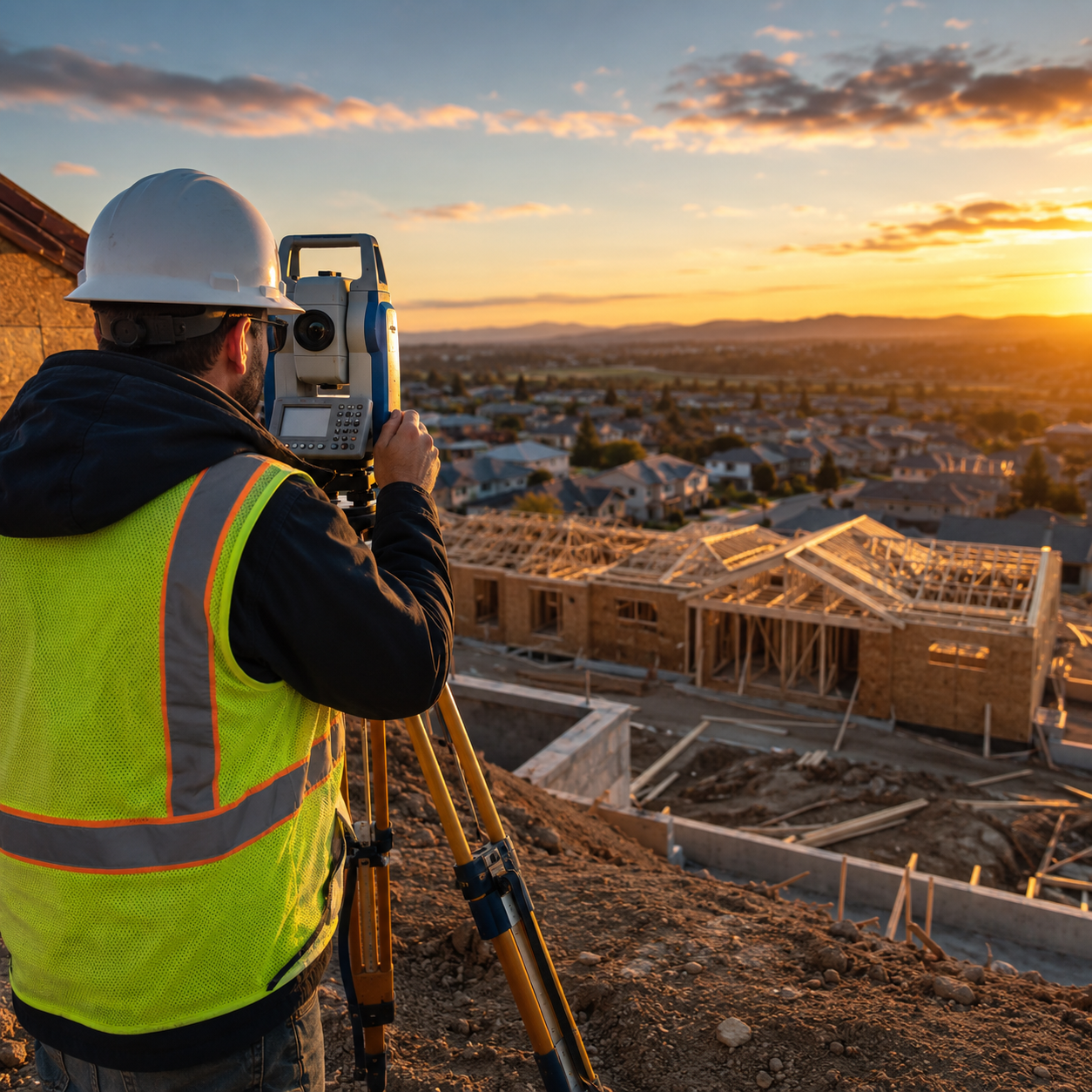
Property owners, developers, and homebuyers face a critical challenge in 2026: understanding the true cost of land surveys amid rising inflation, technological advances, and unprecedented construction demand. Whether planning a boundary dispute resolution, preparing for a new build, or securing a property purchase, knowing what to expect financially can mean the difference between a smooth transaction and costly surprises. This comprehensive guide explores Land Survey Costs in 2026: Complete Guide to Pricing Trends, Inflation Impacts, and Budgeting Strategies, providing actionable insights to help navigate today's surveying landscape with confidence.
Key Takeaways
✅ Basic land surveys in the US range from $300 to $1,200, with complex surveys exceeding $2,000, while UK residential surveys typically cost £300–£800[1][2]
✅ Regional pricing varies dramatically—urban areas like New York and San Francisco charge $1,500+ for basic surveys, while rural locations may charge $500 or less[1]
✅ Inflation and operational costs are driving modest price increases across all survey types, with technology investments and regulatory demands adding to expenses[1]
✅ Survey complexity, property size, terrain difficulty, and local market demand significantly impact final costs, making proper budgeting essential[1]
✅ Strategic planning—including obtaining multiple quotes, bundling services, and scheduling during off-peak seasons—can reduce survey expenses by 15-30%
Understanding Land Survey Costs in 2026: The Current Pricing Landscape
The land surveying industry in 2026 reflects a complex interplay of economic pressures, technological innovation, and market dynamics. Unlike previous years, property owners now face modest but consistent cost increases driven by inflation, rising operational expenses, and heightened demand from construction booms across major metropolitan areas[1].
What Influences Survey Pricing Today?
Several key factors determine how much property owners will pay for surveying services in 2026:
Economic Pressures 🌍
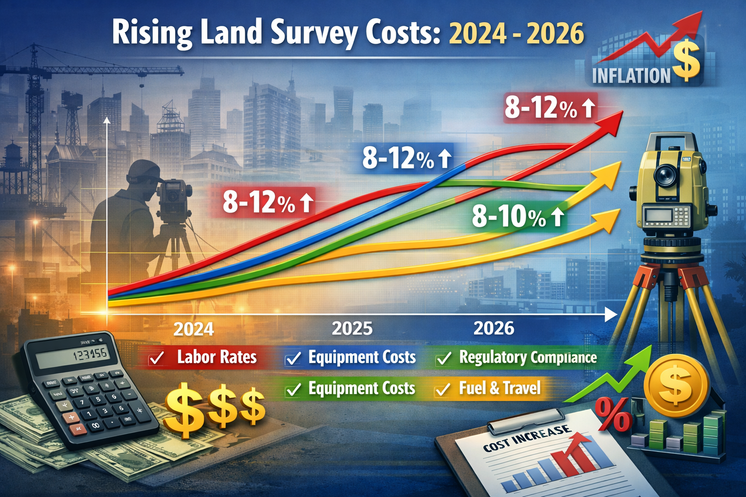
Inflation continues to impact surveyor operating costs, from fuel and equipment maintenance to insurance premiums and professional licensing fees. These increases translate directly to consumer pricing, with most firms implementing 8-12% cost adjustments compared to 2024 rates[1].
Technology Investments
Modern surveying relies heavily on advanced equipment including GPS systems, drone technology, 3D laser scanning, and sophisticated software platforms. While these tools improve accuracy and efficiency, they require substantial capital investment that surveyors must recoup through service fees[6].
Regulatory Compliance
Stricter environmental regulations, data protection requirements, and professional standards demand additional time and expertise from surveying firms. These compliance costs contribute to higher baseline pricing, particularly for commercial and development projects[1].
Market Demand
Construction booms in 2026 have created unprecedented demand for surveying services in certain regions. When demand exceeds supply, prices naturally increase—especially in urban centers experiencing rapid development[1][5].
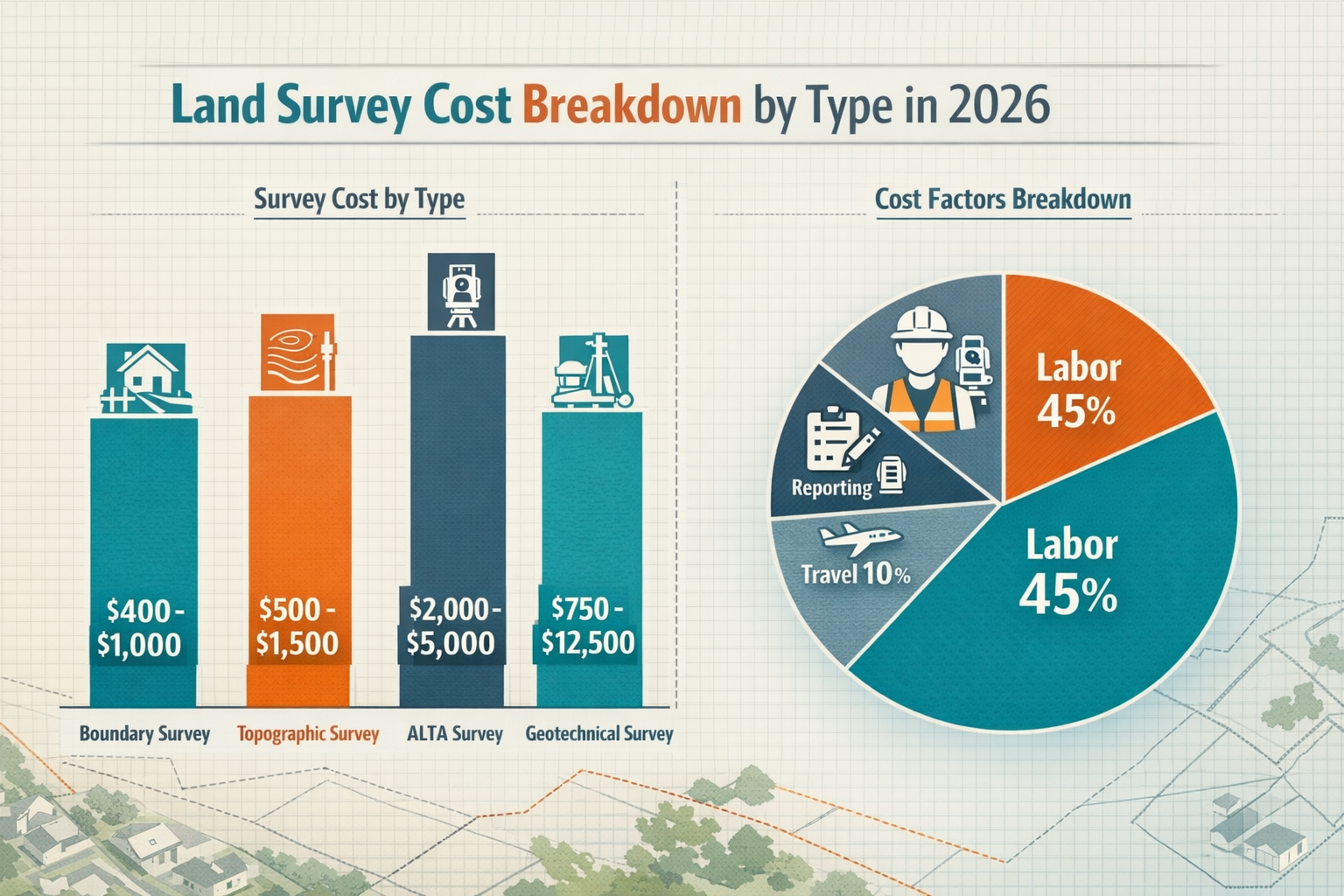
Breaking Down Survey Types and Associated Costs
Understanding the specific type of survey required is essential for accurate budgeting. Here's a comprehensive breakdown of common survey types and their 2026 pricing:
| Survey Type | US Price Range | UK Price Range | Typical Use Case |
|---|---|---|---|
| Boundary Survey | $400–$1,000 | £400–£1,000 | Property line disputes, fence installation |
| Topographic Survey | $500–$1,500 | £500–£1,200 | Construction planning, drainage design |
| ALTA/NSPS Survey | $2,000–$5,000 | £1,500–£4,000 | Commercial transactions, title insurance |
| Geotechnical/Soil Survey | $750–$12,500 | £750–£12,500 | Foundation design, environmental assessment |
| Contaminated Land Survey | $800–$2,500 | £445–£1,900 | Environmental due diligence |
| Subdivision Survey | $1,500–$8,000 | £1,200–£6,500 | Land development, parcel division |
The wide price ranges reflect variations in property size, complexity, accessibility, and regional market conditions[1][2].
For property owners considering comprehensive assessments, understanding surveyor pricing and rates helps contextualize these costs within broader property evaluation expenses.
Regional Variations in Land Survey Costs in 2026: Geographic Pricing Differences
One of the most significant factors affecting Land Survey Costs in 2026: Complete Guide to Pricing Trends, Inflation Impacts, and Budgeting Strategies is geographic location. Surveying fees vary dramatically between urban and rural areas, coastal and inland regions, and different countries entirely.
United States Regional Pricing Patterns
Urban Metropolitan Areas 🏙️
Major cities command premium pricing due to higher operational costs, increased demand, and complex property configurations. In 2026, urban centers demonstrate the following patterns:
- New York City Metro: $1,500–$3,500 for basic boundary surveys
- San Francisco Bay Area: $1,800–$4,000 for standard residential surveys
- Los Angeles: $1,200–$2,800 for typical lot surveys
- Chicago: $1,000–$2,500 for boundary determinations
These elevated costs reflect not only higher business expenses but also the complexity of surveying in densely developed areas with intricate property histories and challenging access conditions[1].
Rural and Suburban Areas
Outside major metropolitan centers, survey costs decrease substantially:
- Rural Midwest: $300–$800 for basic surveys
- Southern rural areas: $400–$900 for standard boundary work
- Mountain West: $500–$1,200 (terrain complexity adds costs)
- Small town suburbs: $450–$1,000 for residential surveys
The lower pricing in these areas reflects reduced overhead costs, less complex property configurations, and typically lower demand pressures[1].
United Kingdom Regional Considerations
UK surveying costs in 2026 show similar geographic variation, though the ranges are somewhat compressed compared to the US market:
London and Southeast England
The capital and surrounding areas command premium rates:
- Day rates for fieldwork: £600–£1,000
- Drawing and reporting: £400–£600 per day
- Standard residential survey: £600–£1,200 total project cost
Regional UK Markets
Outside London, costs moderate considerably:
- Midlands and North: £300–£700 for typical residential surveys
- Scotland and Wales: £350–£800 depending on accessibility
- Rural areas: £300–£600 for standard boundary work[2]
When comparing these costs to other property assessment services, it's helpful to review structural survey pricing to understand the broader context of property evaluation expenses.
International Comparison: Global Surveying Costs
Australia 🌏
Australian survey costs in 2026 range from AUD $800–$2,500 for residential boundary surveys, with urban areas like Sydney and Melbourne at the higher end.
Canada
Canadian pricing mirrors US patterns with CAD $600–$1,800 for standard surveys, though remote northern properties can cost significantly more due to travel requirements.
European Union
Continental European costs vary by country, with Germany, France, and Netherlands ranging €500–€1,500 for typical residential surveys, while Eastern European markets offer lower rates of €300–€800[4].
Inflation Impacts and Pricing Trends Affecting Land Survey Costs in 2026
Understanding how economic forces shape surveying costs helps property owners anticipate expenses and plan accordingly. The Land Survey Costs in 2026: Complete Guide to Pricing Trends, Inflation Impacts, and Budgeting Strategies must account for several inflationary pressures affecting the industry.
Primary Inflation Drivers in Surveying
Labor Cost Increases 💼
Professional surveyors require extensive training, licensing, and continuing education. In 2026, labor represents the single largest cost component:
- Experienced surveyors: $75–$150 per hour (US), £50–£100 per hour (UK)
- Survey technicians: $45–$85 per hour (US), £30–£60 per hour (UK)
- Support staff: $30–$50 per hour (US), £20–£40 per hour (UK)
Wage inflation of 5-8% annually since 2023 has pushed these rates upward, directly impacting survey pricing[1].
Equipment and Technology Costs
Modern surveying equipment requires substantial investment:
- Total station instruments: $15,000–$35,000
- GPS/GNSS systems: $20,000–$60,000
- Drone systems: $5,000–$25,000
- 3D laser scanners: $30,000–$150,000
- Software licenses: $3,000–$15,000 annually[6]
These capital costs, combined with maintenance, calibration, and replacement cycles, contribute 20-25% to overall survey pricing[7].
Fuel and Transportation
With surveyors traveling to job sites regularly, fuel costs significantly impact pricing. The 2026 fuel market, while more stable than previous years, still adds 8-12% to operational expenses compared to 2022 baseline costs[1].
Insurance and Liability
Professional liability insurance for surveyors has increased 15-20% since 2023, driven by higher claim values and increased litigation. This cost passes directly to consumers through higher service fees[1].
Technology's Dual Impact on Pricing
Interestingly, technology creates both upward and downward pressure on survey costs:
Cost Reduction Through Efficiency ⚡
- Drone surveys reduce fieldwork time by 40-60% for large properties
- GPS technology eliminates manual triangulation, cutting labor hours
- Digital workflows reduce drafting time from days to hours
- Cloud collaboration streamlines client communication and revisions[6]
Cost Increases from Specialization
- Advanced equipment requires specialized training and certification
- Software complexity demands ongoing education and technical support
- Data processing needs powerful computing infrastructure
- Regulatory compliance for drone operations adds licensing costs[6]
The net effect in 2026 is modest cost stability for standard surveys, with specialized services commanding premium pricing due to technology requirements[1].
For property owners dealing with specific structural concerns, understanding related costs like damp surveys helps contextualize the value of specialized surveying services.
Market Demand and Construction Boom Effects
The 2026 real estate and construction markets show robust activity in many regions, creating supply-demand imbalances that affect surveying costs:
High-Demand Indicators 📈
- Residential construction up 12% in major US markets
- Commercial development rebounding strongly post-pandemic
- Infrastructure projects funded by government initiatives
- Renewable energy developments requiring extensive surveying[5][8]
In markets experiencing construction booms, survey costs increase 15-25% above baseline rates due to:
- Extended lead times (4-8 weeks vs. 1-2 weeks in normal markets)
- Premium pricing when surveyors can be selective about projects
- Rush fees for expedited service (often 25-50% surcharges)
- Reduced negotiation flexibility when demand exceeds capacity[1]
Predicted Trends Through 2027
Industry analysts project the following cost trajectory for land surveys:
Short-term (2026-2027) 📊
- Gradual increases of 3-5% annually aligned with general inflation
- Technology adoption creating efficiency gains in standard surveys
- Specialized services commanding 10-15% premium pricing
- Regional variation increasing as development patterns diverge[1]
Medium-term (2027-2029)
- AI integration potentially reducing costs for routine surveys by 15-20%
- Regulatory changes possibly adding compliance costs
- Climate considerations increasing demand for environmental surveys
- Workforce shortages potentially driving labor costs higher[6]
Comprehensive Cost Breakdown: What You're Actually Paying For
To fully understand Land Survey Costs in 2026: Complete Guide to Pricing Trends, Inflation Impacts, and Budgeting Strategies, property owners should know exactly what components comprise their survey bill.
Standard Survey Cost Components
Research and Preparation (15-20% of total cost) 🔍
Before fieldwork begins, surveyors invest significant time in:
- Title research: Reviewing deeds, plats, and property records
- Historical document review: Examining previous surveys and easements
- Permit acquisition: Obtaining necessary access permissions
- Site assessment: Evaluating terrain, vegetation, and access challenges
For a $1,000 survey, this represents $150–$200 in preparatory work.
Fieldwork and Data Collection (40-50% of total cost)
The on-site measurement phase includes:
- Boundary location: Identifying and marking property corners
- Topographic mapping: Recording elevation changes and features
- Feature documentation: Noting structures, utilities, and improvements
- Monument setting: Installing permanent boundary markers when required
This labor-intensive phase typically accounts for $400–$500 of a $1,000 survey.
Data Processing and Analysis (15-20% of total cost)
Post-fieldwork activities involve:
- Calculation verification: Ensuring mathematical accuracy
- Boundary determination: Resolving conflicting evidence
- Quality control: Checking measurements against standards
- Digital modeling: Creating 3D representations when applicable
This technical work represents $150–$200 of the total cost.
Reporting and Documentation (15-25% of total cost) 📋
Final deliverables include:
- Survey plat preparation: Creating scaled drawings
- Legal descriptions: Writing precise boundary descriptions
- Certification: Professional seal and signature
- Client presentation: Explaining findings and answering questions
Report preparation accounts for $150–$250 of a typical $1,000 survey.
Additional Fees and Surcharges
Beyond base survey costs, property owners may encounter:
Terrain Difficulty Surcharges
- Steep slopes: +15-30%
- Dense vegetation: +10-25%
- Water features: +20-40%
- Rocky or unstable ground: +15-35%
Access Challenges
- Gated communities: +$50–$150 for coordination
- Remote locations: +$100–$500 for travel time
- Restricted areas: +$75–$200 for special permissions
Expedited Service
- Rush completion (under 1 week): +25-50%
- Same-week service: +50-100%
- Emergency surveys: +100-200%
Complexity Factors
- Irregular boundaries: +15-25%
- Multiple parcels: +$200–$500 per additional parcel
- Easement complications: +$150–$400
- Disputed boundaries: +$300–$1,000 for research and resolution[1][2]
Understanding these cost components helps when comparing quotes and evaluating whether pricing is reasonable for the scope of work required.
For property owners considering comprehensive property assessments, reviewing information about boundary surveys provides additional context for understanding specialized surveying services.
Strategic Budgeting: How to Minimize Land Survey Expenses in 2026
Smart property owners can significantly reduce surveying costs through strategic planning and informed decision-making. These practical strategies help optimize Land Survey Costs in 2026: Complete Guide to Pricing Trends, Inflation Impacts, and Budgeting Strategies without compromising quality or accuracy.
Pre-Survey Preparation Strategies
Gather Existing Documentation 📄
Before contacting surveyors, collect:
- Previous survey plats (even outdated ones provide valuable reference)
- Title documents showing legal descriptions
- Deed records with boundary information
- Property tax maps indicating approximate boundaries
- HOA or subdivision plats if applicable
Providing these documents to surveyors reduces research time by 2-4 hours, potentially saving $150–$400[1].
Clear Property Access
Simple preparation can reduce fieldwork time:
- Mark approximate boundary areas to guide surveyors
- Clear vegetation along suspected property lines (with permission)
- Identify and mark existing monuments if visible
- Arrange gate codes and access permissions in advance
- Secure pets to ensure surveyor safety and efficiency
These actions can reduce fieldwork by 1-2 hours, saving $75–$200.
Define Survey Scope Precisely
Avoid paying for unnecessary services:
- Boundary-only survey if topographic data isn't needed
- Corners-only staking if full boundary marking isn't required
- Digital delivery instead of multiple printed copies
- Standard turnaround rather than rush service
Precise scope definition prevents 15-25% cost overruns from scope creep[2].
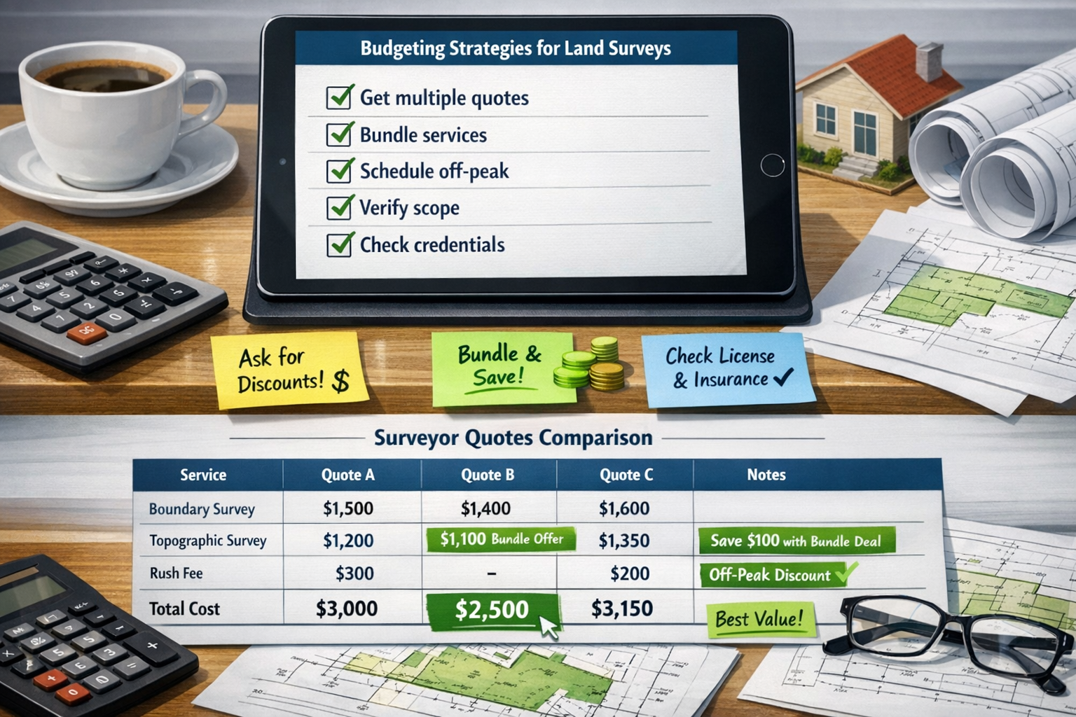
Obtaining and Comparing Multiple Quotes
Request Detailed Proposals 💰
When soliciting quotes, ask for:
- Itemized cost breakdowns showing each service component
- Specific deliverables included in the quoted price
- Timeline estimates for completion
- Additional fee schedules for potential extras
- Credential verification (license numbers, insurance coverage)
Comparing 3-5 detailed quotes typically reveals 20-35% pricing variation for identical services[1].
Evaluate Value, Not Just Price
The lowest quote isn't always the best value. Consider:
- Surveyor experience with similar properties
- Technology capabilities affecting accuracy and efficiency
- Professional reputation and client reviews
- Error and omission insurance protecting against mistakes
- Turnaround reliability meeting your timeline needs
A mid-range quote from an experienced firm often provides better long-term value than the cheapest option.
Negotiate Strategically
Many surveyors offer flexibility on:
- Multi-service bundling (survey + staking + monitoring)
- Off-peak scheduling (winter months, weekdays)
- Payment terms (deposit vs. full payment)
- Referral discounts for multiple properties or recommendations
- Professional courtesy for architects, builders, or real estate professionals
Respectful negotiation can reduce costs by 10-15% without compromising quality[2].
Timing Your Survey for Cost Savings
Seasonal Considerations 🌤️
Survey costs vary by season:
Peak Season (Spring/Summer)
- Highest demand and pricing
- Shortest lead times (surveyors busiest)
- Best weather conditions
- Premium rates (+15-25% above baseline)
Shoulder Season (Fall)
- Moderate demand and pricing
- Reasonable lead times
- Good weather conditions
- Standard rates
Off-Peak Season (Winter)
- Lowest demand and pricing
- Longer lead times (weather delays possible)
- Challenging conditions in northern climates
- Discount rates (-10-20% below peak)[1]
For non-urgent surveys, winter scheduling can save $150–$400 on a typical $1,000 survey.
Market Timing
Survey costs fluctuate with real estate activity:
- Market slowdowns: More competitive pricing, negotiation flexibility
- Market booms: Premium pricing, limited availability
- Economic uncertainty: Stable or slightly reduced pricing
- Construction cycles: Higher costs during building booms[5]
Bundling Services for Better Value
Combined Survey Services 📦
Ordering multiple services together often reduces total costs:
Boundary + Topographic Survey
- Separate pricing: $800 + $1,200 = $2,000
- Bundled pricing: $1,600–$1,800 (10-20% savings)
Survey + Staking + Monitoring
- Separate pricing: $1,000 + $600 + $800 = $2,400
- Bundled pricing: $2,000–$2,200 (8-17% savings)
Multi-Property Discounts
- Single property: $1,000
- Three adjacent properties: $2,400–$2,700 (20-25% savings per property)
Bundling eliminates duplicate research, travel, and mobilization costs[2].
For property owners requiring specialized assessments beyond standard surveys, exploring options like structural surveys can provide comprehensive property evaluation while potentially bundling services for cost efficiency.
DIY Preparation to Reduce Professional Time
Property Line Research 🔎
Before hiring a surveyor:
- Review county GIS maps (often free online)
- Locate property corners using metal detectors
- Photograph potential monuments for surveyor review
- Document encroachments or boundary concerns
- Measure approximate distances for preliminary understanding
This preparation helps surveyors work more efficiently, reducing billable hours by 1-3 hours ($75–$300 savings).
Vegetation Management
With property owner permission:
- Clear sight lines between potential corner locations
- Remove brush along suspected boundary paths
- Mark obstacles that might impede surveyor movement
- Create access paths through dense areas
Vegetation clearing can reduce fieldwork by 2-4 hours on heavily wooded properties, saving $150–$400[1].
Neighbor Coordination
Proactive communication prevents delays:
- Notify adjacent owners of upcoming survey work
- Arrange access across neighboring properties if needed
- Resolve access disputes before surveyor arrival
- Coordinate schedules if neighbors want joint boundary surveys
Preventing access delays saves both time and money.
Common Survey Types: Detailed Cost Analysis for 2026
Different survey types serve distinct purposes and carry varying price points. This section provides detailed cost analysis for the most common surveys property owners encounter in 2026.
Boundary Survey: Establishing Property Lines
Purpose and Applications 🏡
Boundary surveys definitively establish property line locations through:
- Legal research of deeds and records
- Field measurement and monument location
- Boundary determination and marking
- Plat preparation showing findings
Typical Cost Ranges
- US pricing: $400–$1,000 for standard residential lots
- UK pricing: £400–£1,000 for typical properties
- Urban premium: +25-50% in major cities
- Rural discount: -15-30% in less developed areas[1][2]
Cost Variables
- Lot size: Small urban lots cost less than multi-acre parcels
- Boundary complexity: Irregular shapes increase costs
- Monument condition: Missing corners require extensive research
- Vegetation density: Heavy growth adds fieldwork time
- Historical clarity: Well-documented properties cost less
When You Need It
- Installing fences or structures near property lines
- Resolving neighbor disputes about boundaries
- Subdividing property for development
- Satisfying title insurance requirements
- Planning additions or improvements
Topographic Survey: Mapping Terrain Features
Purpose and Applications 🗺️
Topographic surveys document:
- Elevation changes and contours
- Natural features (trees, water, rock formations)
- Existing structures and improvements
- Utilities and infrastructure
- Drainage patterns and flow
Typical Cost Ranges
- US pricing: $500–$1,500 for residential properties
- UK pricing: £500–£1,200 for standard lots
- Large properties: $2,000–$5,000+ for multi-acre sites
- Complex terrain: +30-60% for steep or irregular topography[1][2]
Cost Variables
- Property size: Larger areas require more data collection
- Terrain complexity: Steep slopes increase difficulty
- Detail level: Engineering-grade surveys cost more
- Deliverable format: 3D modeling adds processing costs
- Feature density: More structures mean more documentation
When You Need It
- Planning new construction or additions
- Designing drainage or grading systems
- Preparing site development plans
- Engineering foundation designs
- Environmental impact assessments
ALTA/NSPS Survey: Commercial Transaction Standard
Purpose and Applications 🏢
ALTA surveys provide comprehensive property information for:
- Commercial real estate transactions
- Title insurance underwriting
- Lender due diligence requirements
- Investment property acquisitions
- Complex boundary determinations
Typical Cost Ranges
- US pricing: $2,000–$5,000 for standard commercial properties
- Large sites: $5,000–$15,000+ for complex properties
- Urban locations: Premium pricing due to complexity
- Multi-parcel: +$1,500–$3,000 per additional parcel[1]
Cost Variables
- Property size and complexity
- Table A optional items requested
- Zoning research requirements
- Easement documentation complexity
- Underground utility location needs
When You Need It
- Commercial property purchases
- Refinancing commercial real estate
- Title insurance requirements
- Lender underwriting demands
- Investment due diligence
Understanding these specialized survey types helps when evaluating comprehensive property assessments. For residential buyers, comparing these costs with homebuyer survey options provides valuable context for budgeting property evaluation expenses.
Geotechnical and Soil Survey: Foundation and Environmental Analysis
Purpose and Applications 🌱
Geotechnical surveys investigate:
- Soil composition and bearing capacity
- Groundwater levels and drainage
- Contamination presence and extent
- Foundation suitability assessment
- Environmental hazard identification
Typical Cost Ranges
- Basic soil testing: $750–$2,500
- Comprehensive geotechnical: $2,500–$7,500
- Contaminated land survey: $445–$1,900 (UK), $800–$2,500 (US)
- Extensive environmental: $5,000–$12,500+[1][2]
Cost Variables
- Number of test borings required
- Depth of investigation needed
- Laboratory analysis complexity
- Environmental contamination concerns
- Report detail and engineering recommendations
When You Need It
- Planning major construction projects
- Investigating foundation problems
- Assessing environmental liabilities
- Developing previously industrial sites
- Engineering complex structures
Subdivision Survey: Dividing Property Parcels
Purpose and Applications 📐
Subdivision surveys create new legal parcels through:
- Boundary determination of parent parcel
- Division design meeting zoning requirements
- Monument setting for new boundaries
- Plat preparation for recording
- Legal description writing
Typical Cost Ranges
- Simple 2-lot division: $1,500–$3,500
- Multi-lot subdivision: $3,000–$8,000+
- Complex developments: $10,000–$50,000+
- Per-lot costs: Decrease with quantity[1][2]
Cost Variables
- Number of new parcels created
- Zoning compliance requirements
- Infrastructure planning needs
- Environmental considerations
- Municipal approval process complexity
When You Need It
- Dividing property for family members
- Developing land for sale or construction
- Creating separate parcels for financing
- Complying with inheritance divisions
- Maximizing property value through subdivision
Technology's Role in Modern Land Surveying Costs
The surveying profession has undergone dramatic technological transformation, directly impacting Land Survey Costs in 2026: Complete Guide to Pricing Trends, Inflation Impacts, and Budgeting Strategies. Understanding these technological influences helps property owners appreciate both the value and cost of modern surveying services.
Advanced Equipment and Techniques
GPS/GNSS Technology 🛰️
Global positioning systems revolutionized surveying:
Benefits:
- Sub-centimeter accuracy without line-of-sight requirements
- Rapid data collection reducing fieldwork time
- Consistent accuracy across large properties
- Integration with GIS and mapping systems
Cost Impact:
- Equipment investment: $20,000–$60,000 per system
- Subscription services: $2,000–$5,000 annually
- Training requirements: $3,000–$8,000 per surveyor
- Net effect: 20-30% reduction in fieldwork time, offsetting technology costs[6]
Drone and UAV Surveying
Unmanned aerial vehicles transform large-area surveying:
Benefits:
- 40-60% faster data collection for properties over 5 acres
- Access to difficult or dangerous terrain
- High-resolution aerial imagery
- 3D modeling capabilities
Cost Impact:
- Drone systems: $5,000–$25,000
- Pilot certification: $1,500–$3,000
- Insurance premiums: +15-20%
- Regulatory compliance: Ongoing costs
- Net effect: Significant savings on large properties, minimal impact on small lots[6][7]
3D Laser Scanning
Terrestrial laser scanning captures millions of data points:
Benefits:
- Comprehensive as-built documentation
- Detailed structural measurements
- Point cloud data for BIM integration
- Historical preservation accuracy
Cost Impact:
- Scanner investment: $30,000–$150,000
- Software licenses: $5,000–$15,000 annually
- Processing workstations: $3,000–$8,000
- Net effect: Premium pricing (+50-100%) for specialized applications[6]
Software and Data Processing
CAD and Design Software 💻
Modern surveying relies on sophisticated software:
- AutoCAD Civil 3D: Industry standard for survey drafting
- Trimble Business Center: Comprehensive data processing
- Carlson Survey: Specialized surveying calculations
- QGIS: Open-source mapping and analysis
Cost Impact:
- Software licenses: $3,000–$10,000 per seat annually
- Training and certification: $2,000–$5,000 per employee
- IT infrastructure: $5,000–$15,000 for servers and backup
- These costs add 8-12% to survey pricing but improve accuracy and deliverable quality[6]
Cloud Collaboration Platforms
Modern projects use cloud-based tools:
- Real-time data sharing with clients
- Multi-party collaboration on complex projects
- Version control and document management
- Mobile access for field crews
Cost Impact:
- Platform subscriptions: $100–$500 per user monthly
- Data storage: $500–$2,000 annually
- Security compliance: $1,000–$3,000 annually
- Net effect: Improved client service with minimal cost increase[6]
Artificial Intelligence and Automation
AI-Powered Analysis 🤖
Emerging AI applications in surveying include:
- Automated feature extraction from imagery
- Boundary determination assistance
- Anomaly detection in survey data
- Report generation and formatting
Cost Impact (Projected 2026-2028):
- Initial implementation: High capital investment
- Long-term efficiency: 15-20% reduction in processing time
- Accuracy improvement: Reduced error rates and liability
- Market effect: Potential 10-15% cost reduction for routine surveys by 2028[6]
Robotic Total Stations
Self-leveling, automated measurement systems:
- Single-operator efficiency (vs. traditional two-person crews)
- Automated tracking and measurement
- Integrated data recording
- Real-time quality control
Cost Impact:
- Equipment investment: $15,000–$35,000
- Reduced labor costs: One-person operation saves $200–$400 per day
- Increased accuracy: Fewer callbacks and corrections
- Net effect: 15-25% efficiency gain on large projects[7]
For property owners interested in specialized surveying applications, understanding monitoring surveys demonstrates how technology enables ongoing structural assessment and movement tracking.
Regulatory and Compliance Factors Affecting Survey Costs
Professional surveying operates within strict regulatory frameworks that significantly influence Land Survey Costs in 2026: Complete Guide to Pricing Trends, Inflation Impacts, and Budgeting Strategies.
Professional Licensing and Standards
Surveyor Licensing Requirements 📜
All US states and UK jurisdictions require:
- Educational credentials: Bachelor's degree in surveying or related field
- Experience requirements: 4+ years supervised practice
- Professional examinations: Fundamentals and Principles exams
- Continuing education: 15-30 hours annually
- License renewal: Every 1-2 years with fees
Cost Impact:
- Education investment: $80,000–$150,000
- Examination fees: $500–$1,000
- Annual renewal: $200–$500
- Continuing education: $1,000–$2,500 annually
- These professional requirements add 5-8% to survey costs but ensure quality and accountability[1]
Professional Standards Compliance
Surveyors must adhere to:
- ALTA/NSPS Standards: Commercial survey requirements
- State-specific standards: Minimum technical standards
- RICS guidelines: UK professional standards
- ISO certifications: International quality standards
Cost Impact:
- Standards compliance adds 10-15% to specialized surveys
- Quality assurance procedures increase processing time
- Documentation requirements expand deliverable scope
- Net effect: Higher costs but greater reliability and legal defensibility[3]
Insurance and Liability
Professional Liability Coverage 🛡️
Surveyors carry substantial insurance:
- Errors and omissions: $1-2 million coverage typical
- General liability: $1-2 million coverage
- Workers compensation: State-mandated coverage
- Auto insurance: Commercial vehicle coverage
Cost Impact:
- Annual premiums: $8,000–$25,000 for small firms
- Premium increases: 15-20% since 2023
- Claims history: Affects individual firm rates
- These insurance costs add 8-12% to survey pricing[1]
Legal and Regulatory Compliance
Modern surveying faces increasing regulation:
- Data protection: GDPR, privacy law compliance
- Environmental regulations: Protected species, wetlands
- Drone regulations: FAA Part 107 compliance
- Safety standards: OSHA workplace requirements
Cost Impact:
- Compliance systems: $5,000–$15,000 implementation
- Ongoing monitoring: $2,000–$5,000 annually
- Training programs: $1,500–$4,000 per employee
- Net effect: 5-8% increase in operational costs[1][6]
Future Outlook: Land Survey Cost Predictions for 2027 and Beyond
Understanding projected trends helps property owners plan for future surveying needs and budget accordingly within Land Survey Costs in 2026: Complete Guide to Pricing Trends, Inflation Impacts, and Budgeting Strategies.
Economic Forecasts and Inflation Projections
General Inflation Trends 📈
Economic analysts project:
- 2026-2027 inflation: 2.5-3.5% annually
- Construction sector inflation: 3-4% annually
- Professional services inflation: 3.5-4.5% annually
- Technology deflation: -2% to -5% for equipment costs[4][5]
Survey Cost Implications:
- Baseline survey costs: +3-5% annually through 2027
- Technology-enabled surveys: Stable or slight decreases
- Specialized surveys: +5-8% due to complexity and regulation
- Labor-intensive surveys: +6-10% due to wage pressures[1]
Technology Adoption Impact
Near-Term Technology Trends (2026-2028) 🚀
- AI integration: Reducing processing time by 15-20%
- Drone standardization: Becoming routine for properties over 2 acres
- Mobile LiDAR: Enabling rapid large-area surveys
- Real-time kinematic (RTK) GPS: Improving accuracy and efficiency
Cost Impact Predictions:
- Routine surveys: 5-10% cost reduction from efficiency gains
- Complex surveys: 10-15% cost increase from technology requirements
- Specialized surveys: Premium pricing for advanced capabilities
- Overall market: Modest stabilization with selective decreases[6][7]
Market Demand Projections
Construction and Development Outlook 🏗️
Industry forecasts for 2026-2028:
- Residential construction: Moderate growth (3-5% annually)
- Commercial development: Strong recovery (8-12% annually)
- Infrastructure projects: Government-funded expansion
- Renewable energy: Continued strong demand for site surveys[5][8]
Survey Demand Implications:
- High-growth markets: Continued premium pricing (+15-25%)
- Stable markets: Gradual inflation-aligned increases
- Declining markets: Competitive pricing and negotiation opportunities
- Specialized niches: Strong demand maintaining premium rates[1][5]
Workforce and Capacity Considerations
Surveyor Shortage Concerns 👥
The surveying profession faces:
- Aging workforce: 40% of surveyors approaching retirement
- Limited new entrants: Declining enrollment in surveying programs
- Competing industries: Technology sector attracting talent
- Geographic imbalances: Urban concentration of professionals
Cost Impact:
- Labor shortages: Potential 10-20% wage inflation by 2028
- Extended timelines: Reduced capacity increasing lead times
- Premium pricing: High-demand areas commanding surcharges
- Technology substitution: Automation offsetting workforce gaps[1][3]
For property owners planning comprehensive assessments, understanding the relationship between various survey types and complementary services like building surveys helps create integrated property evaluation strategies.
Frequently Asked Questions About Land Survey Costs in 2026
How much does a typical land survey cost in 2026?
In the United States, basic land surveys range from $300 to $1,200 for standard residential properties, with complex surveys exceeding $2,000. In the UK, typical residential surveys cost £300 to £800, with total project costs around £1,100 for standard properties. Urban areas command premium pricing, with major cities like New York and San Francisco charging $1,500+ for basic surveys, while rural areas may charge $500 or less[1][2].
What factors most significantly affect survey costs?
The primary cost drivers include:
- Property size and complexity (irregular boundaries, multiple parcels)
- Geographic location (urban vs. rural, regional market conditions)
- Survey type and scope (boundary vs. topographic vs. ALTA)
- Terrain difficulty (steep slopes, dense vegetation, water features)
- Market demand (construction booms increase costs 15-25%)
- Technology requirements (specialized equipment for complex surveys)[1][2]
Are land survey costs tax deductible?
Survey costs may be tax deductible depending on purpose:
- Investment property: Generally deductible as business expense
- Primary residence: Typically added to property basis, not immediately deductible
- Commercial property: Deductible as acquisition or improvement cost
- Development projects: Capitalized as project cost
Consult a tax professional for specific guidance based on individual circumstances.
How can I reduce land survey costs without compromising quality?
Effective cost-reduction strategies include:
- Obtain multiple detailed quotes (3-5 proposals)
- Schedule during off-peak seasons (winter months, 10-20% savings)
- Provide existing documentation (previous surveys, deeds, reducing research time)
- Clear property access (remove vegetation, arrange permissions)
- Bundle multiple services (survey + staking, 10-20% savings)
- Define precise scope (avoid unnecessary services)
- Negotiate payment terms (deposit vs. full payment)[1][2]
How long does a typical land survey take to complete?
Timeline varies by survey type and complexity:
- Simple boundary survey: 1-2 weeks from order to delivery
- Topographic survey: 2-3 weeks for standard residential
- ALTA/NSPS survey: 3-6 weeks due to research requirements
- Complex surveys: 4-8 weeks for large or complicated properties
- Rush service: Available with 25-50% premium pricing
High-demand markets may extend timelines by 2-4 weeks due to surveyor capacity constraints[1].
Do I need a survey if I already have an old one?
Previous surveys may be insufficient because:
- Property changes: New structures, fences, or improvements
- Boundary disputes: Neighbor encroachments since original survey
- Lender requirements: Many require surveys less than 5 years old
- Accuracy standards: Modern technology provides superior accuracy
- Legal changes: Updated zoning or easement modifications
An existing survey reduces new survey costs by providing reference information, but rarely eliminates the need for updated work[1].
What's the difference between a survey and an appraisal?
Land Survey:
- Determines precise property boundaries and features
- Performed by licensed surveyors
- Legal document establishing ownership limits
- Required for construction, disputes, transactions
- Costs $300-$5,000+ depending on type
Property Appraisal:
- Determines market value of property
- Performed by licensed appraisers
- Financial document for lending and taxation
- Required for mortgages, refinancing, sales
- Costs $300-$600 for residential properties
Both serve different purposes and are often required simultaneously for property transactions.
Conclusion: Making Informed Decisions About Land Survey Costs in 2026
Understanding Land Survey Costs in 2026: Complete Guide to Pricing Trends, Inflation Impacts, and Budgeting Strategies empowers property owners to make confident, informed decisions about this essential service. While costs have increased modestly due to inflation, operational expenses, and market demand, strategic planning and informed budgeting can significantly reduce expenses without compromising quality or accuracy.
Key Takeaways for Property Owners
Budget Realistically 💡
Expect to pay:
- $300-$1,200 for basic US residential surveys
- £300-£800 for standard UK residential surveys
- Premium pricing (+25-50%) in major urban areas
- Complexity surcharges for difficult terrain or irregular boundaries
- Seasonal variation (10-20% savings in off-peak periods)[1][2]
Prioritize Quality Over Price
The cheapest survey isn't always the best value:
- Verify surveyor credentials and licensing
- Review professional liability insurance coverage
- Check client references and project experience
- Evaluate technology capabilities and deliverable quality
- Consider long-term reliability over short-term savings
Plan Strategically
Maximize value through:
- Obtaining multiple detailed proposals
- Scheduling during off-peak seasons
- Bundling multiple services when possible
- Providing comprehensive documentation
- Preparing property access in advance
Understand Market Context
Survey costs reflect:
- Regional economic conditions and demand
- Construction market activity and development pressure
- Technology investments improving accuracy and efficiency
- Regulatory requirements ensuring professional standards
- Inflation and operational cost increases[1][3]
Actionable Next Steps
For Immediate Survey Needs: 📋
- Define precise survey requirements (boundary, topographic, ALTA)
- Gather existing documentation (deeds, previous surveys, tax maps)
- Request 3-5 detailed proposals from licensed surveyors
- Verify credentials and insurance for all candidates
- Compare value propositions, not just pricing
- Schedule during optimal timing balancing urgency and cost
- Prepare property access to minimize fieldwork time
For Future Planning:
- Budget 3-5% annual increases for surveys needed in 2027-2028
- Monitor local construction activity affecting surveyor availability
- Maintain survey documentation for future reference and cost reduction
- Establish surveyor relationships for ongoing property needs
- Stay informed about technology advances and regulatory changes
For Complex Projects:
- Consult multiple specialists for unusual requirements
- Consider phased approaches spreading costs over time
- Explore bundled services with related professionals
- Investigate technology options (drones, 3D scanning) for efficiency
- Engage early in project planning to optimize survey scope and timing
The Value Proposition
While survey costs represent a significant investment, the value provided far exceeds the expense:
Risk Mitigation 🛡️
- Prevents costly boundary disputes and litigation
- Identifies encroachments before they become problems
- Ensures compliance with zoning and setback requirements
- Protects property rights and ownership interests
Financial Protection
- Satisfies lender and title insurance requirements
- Prevents construction errors and costly corrections
- Enables accurate property valuation and taxation
- Supports informed real estate decisions
Legal Documentation
- Creates defensible legal records of property boundaries
- Establishes baseline for future reference and comparison
- Provides evidence for dispute resolution
- Ensures regulatory compliance and permitting
Looking Forward
The land surveying industry in 2026 reflects a profession in transition—balancing traditional expertise with technological innovation, managing inflationary pressures while improving efficiency, and serving increasing demand amid workforce constraints. Property owners who understand these dynamics and plan accordingly will secure high-quality surveying services at fair prices while avoiding costly mistakes and delays.
By applying the insights and strategies outlined in this Land Survey Costs in 2026: Complete Guide to Pricing Trends, Inflation Impacts, and Budgeting Strategies, property owners can navigate the surveying landscape with confidence, making informed decisions that protect their investments and support their property goals.
Whether planning a simple boundary determination, preparing for major construction, or resolving a property dispute, investing in professional surveying services provides essential protection, documentation, and peace of mind that far outweighs the cost.
For comprehensive property evaluation beyond land surveys, consider exploring additional services such as structural surveys and specialized assessments to ensure complete understanding of property conditions and value.
References
[1] Blog Land Survey Costs 2026 – https://www.thelandgeek.com/blog-land-survey-costs-2026/
[2] Land Survey Cost – https://www.checkatrade.com/blog/cost-guides/land-survey-cost/
[3] Surveying In 2026 Reform Recovery And Renewed Demand – https://www.lrg.co.uk/news-and-insights/surveying-in-2026-reform-recovery-and-renewed-demand/
[4] Europe – https://www.pwc.com/gx/en/industries/financial-services/real-estate/emerging-trends-real-estate/europe.html
[5] Emerging Trends In Real Estate United States And Canada 2026 – https://knowledge.uli.org/reports/emerging-trends/2026/emerging-trends-in-real-estate-united-states-and-canada-2026
[6] The Future Of Land Surveying Technology And Upcoming Trends In 2026 – https://metricop.com/blogs/land-surveying/the-future-of-land-surveying-technology-and-upcoming-trends-in-2026
[7] Land Survey Equipment Market – https://www.futuremarketinsights.com/reports/land-survey-equipment-market
[8] Commercial Real Estate Outlook – https://www.deloitte.com/us/en/insights/industry/financial-services/commercial-real-estate-outlook.html