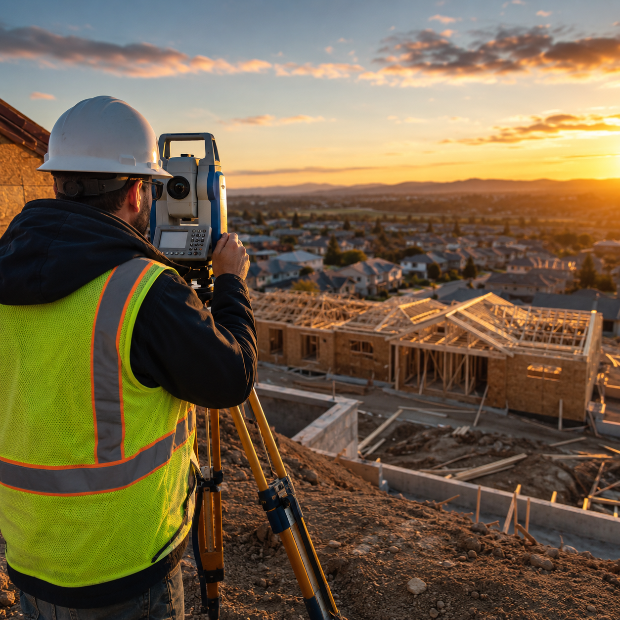
The surveying industry stands at a pivotal moment in 2026. What was once considered cutting-edge technology reserved for large-scale infrastructure projects and Fortune 500 companies has now become an accessible standard for everyday surveys. Reality capture goes mainstream: implementing 3D laser scanning and mobile mapping for everyday surveys represents more than just technological advancement—it signals a fundamental shift in how surveying professionals approach their work, from small residential inspections to complex commercial projects.
Gone are the days when 3D laser scanning required specialized operators, prohibitive budgets, and weeks of processing time. Today's reality capture tools are user-friendly, affordable, and deliver results in hours rather than weeks. Small surveying firms, independent contractors, and even property inspectors are now leveraging these technologies to accelerate project timelines, improve safety outcomes, and deliver unprecedented accuracy to their clients.
Key Takeaways
- 📊 Mobile laser scanning costs 50-70% less in field acquisition compared to traditional methods, making reality capture accessible to small firms and individual contractors in 2026
- ⚡ Hybrid workflows combining static and mobile scanning have become industry best practice, balancing survey-grade precision (1.9mm) with rapid data collection (10x faster)
- 🏗️ Construction dominates adoption, with mobile laser scanning now standard for 3D modeling, site surveying, and real-time progress monitoring across projects of all sizes
- 🎯 SLAM technology enables GPS-free mapping in underground tunnels, crowded urban centers, and disaster zones, expanding applications beyond traditional surveying environments
- 💼 Small firms can now compete with enterprise-level accuracy and efficiency, as democratized technology levels the playing field in the surveying industry
Understanding the Reality Capture Revolution
What Is Reality Capture?
Reality capture refers to the process of digitally documenting physical spaces, objects, or environments using advanced scanning technologies. Unlike traditional surveying methods that collect individual measurement points, reality capture technologies generate comprehensive 3D representations of entire spaces—complete with millions of precise data points that form detailed digital models.
The two primary technologies driving this revolution are:
- 3D Laser Scanning (Terrestrial Laser Scanning/TLS): Static, tripod-mounted devices that emit laser beams to measure distances with survey-grade precision
- Mobile Mapping (Mobile LiDAR with SLAM): Portable, handheld or vehicle-mounted systems that capture data while moving through spaces
Why 2026 Marks the Tipping Point
Several converging factors have accelerated reality capture adoption in 2026:
Technology Democratization 🚀
Devices that once cost £100,000+ are now available for under £20,000, with entry-level professional systems starting below £10,000. This price reduction has opened doors for small surveying firms that previously couldn't justify the capital investment.
User-Friendly Interfaces
Modern reality capture platforms feature intuitive touchscreen controls, automated workflows, and cloud-based processing that eliminate the need for specialized technical training. Surveyors can now achieve professional results after just days of familiarization rather than months of certification courses.
Integration with Existing Workflows
Today's reality capture tools seamlessly integrate with popular platforms like AutoCAD, Revit, and BIM software, allowing firms to incorporate 3D data into their existing project delivery methods without disrupting established processes. This compatibility has removed a major adoption barrier for traditional structural surveys and commercial building surveys.
Market Demand Acceleration
The global mobile laser scan systems market is projected to witness significant growth through 2034, driven by increasing demand across diverse sectors and the integration of mobile laser scanning with complementary technologies like drones and GPS.[5]
The Construction Industry Leading the Charge
The construction industry represents the largest application segment for mobile laser scanning systems, with the technology being used for precise 3D modeling, site surveying, and real-time progress monitoring.[5] This dominance reflects construction's unique needs:
| Traditional Challenge | Reality Capture Solution |
|---|---|
| Time-consuming manual measurements | Capture entire sites in hours |
| Human error in data collection | Millimeter-level accuracy |
| Safety risks from accessing dangerous areas | Remote scanning from safe positions |
| Difficulty tracking construction progress | Automated as-built documentation |
| Disputes over existing conditions | Indisputable 3D evidence |
Mining and agriculture follow as secondary growth sectors, with mining applications focused on underground mapping and safety documentation.[5]
Reality Capture Goes Mainstream: The Technology Behind the Transformation
Understanding the Precision-Speed Trade-Off
One of the most important considerations when reality capture goes mainstream: implementing 3D laser scanning and mobile mapping for everyday surveys involves understanding the fundamental trade-off between precision and speed.
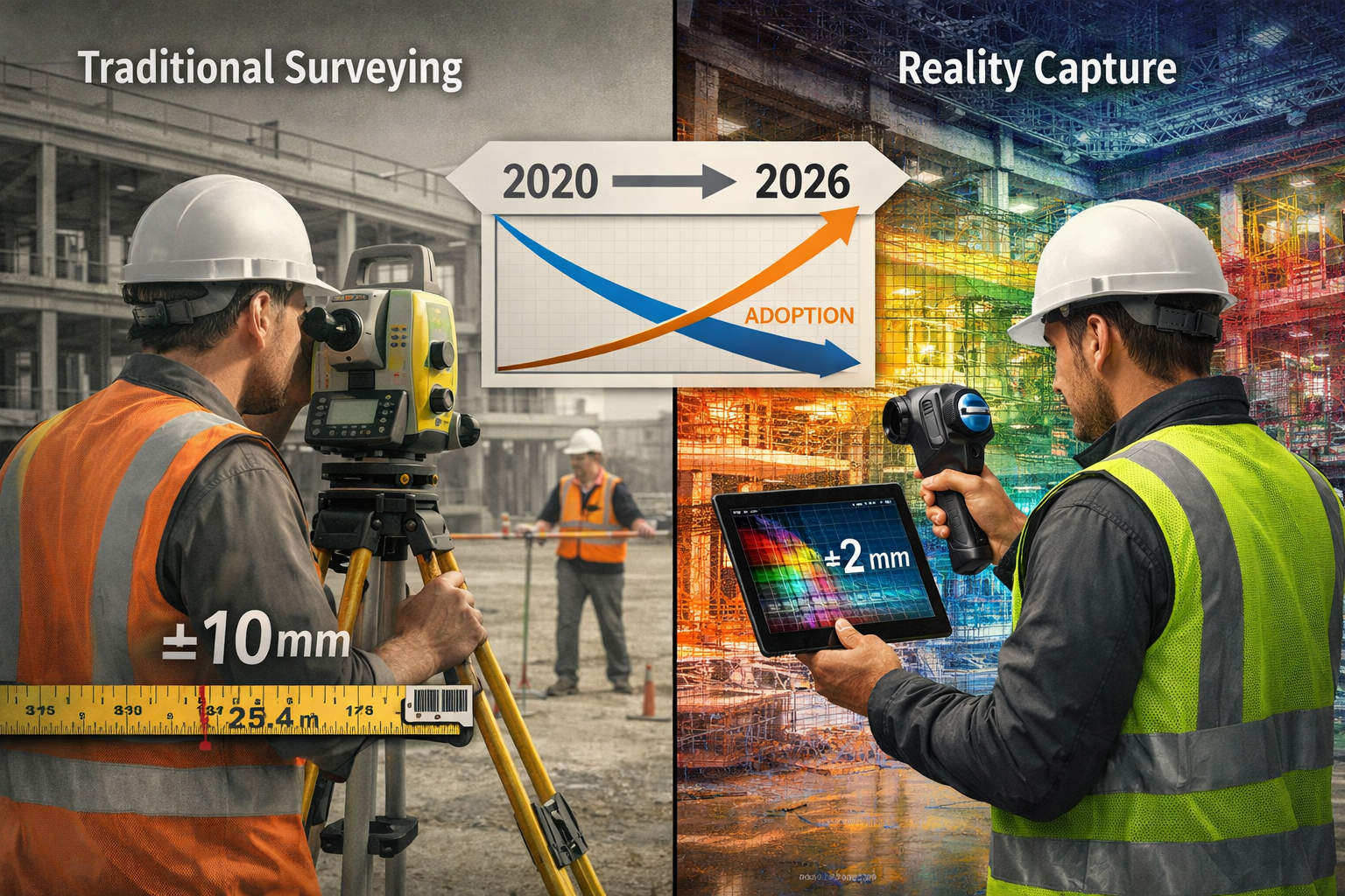
Static Terrestrial Laser Scanning (TLS) delivers survey-grade precision of 1.9mm but operates slowly, requiring setup time at each scanning position.[4] A typical commercial building might require 50-100 individual scan positions, with each position taking 5-15 minutes to complete.
Mobile LiDAR (SLAM-based) is approximately 10x faster but maintains real-world accuracy of 15-20mm due to drift accumulation over longer scanning sessions.[4] This trade-off has driven the adoption of hybrid workflows combining both technologies.[4]
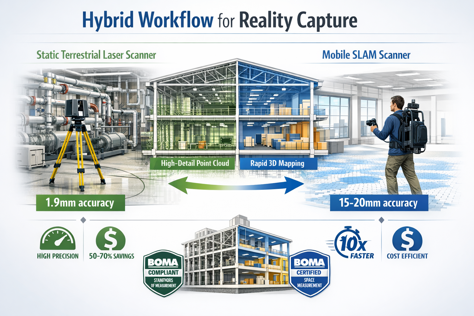
The Hybrid Capture Strategy
The industry best practice in 2026 combines:
✅ Static scanners for survey control ("skeleton")
Used for mechanical rooms, elevator shafts, stairwells, and areas requiring floor flatness verification (FF/FL standards). These high-precision scans serve as control points that anchor the entire dataset.
✅ Mobile scanners for rapid infill ("meat")
Used for open floor areas, corridors, and large spaces where speed matters more than millimeter-level precision. Mobile SLAM excels for BOMA rentable area calculations and as-built documentation.[4]
This strategic combination optimizes both precision where critical and speed where acceptable, delivering project efficiency without compromising accuracy requirements.[4]
SLAM Technology: The Game-Changer
Simultaneous Localization and Mapping (SLAM) technology has revolutionized reality capture by eliminating GPS dependency. SLAM enables mobile mapping in areas without GPS access—underground tunnels, crowded urban centers, and disaster zones—by simultaneously mapping areas while tracking device location in real-time.[1]
How SLAM Works:
- Sensors capture environment data (laser, camera, IMU)
- Algorithm identifies features in the surrounding space
- System tracks movement relative to identified features
- Continuous position updates refine the map in real-time
- Loop closure detection corrects drift when returning to known locations
SLAM-equipped robots now autonomously navigate underground mines and create high-resolution maps in GPS-denied environments.[1] This capability has expanded applications far beyond traditional surveying scenarios, making reality capture viable for damp surveys in basements, subsidence surveys in challenging terrain, and emergency response documentation.
Handheld Devices Transforming On-Site Workflows
Handheld SLAM devices represent perhaps the most transformative development for everyday surveys. These portable systems collect spatial data in hard-to-access construction areas without compromising data quality, allowing teams to capture real-time data during ongoing projects without halting operations.[2]
Advantages of Handheld Systems:
🎯 Accessibility: Navigate tight spaces, stairs, and cluttered environments
⚡ Speed: Walk through spaces at normal pace while capturing data
💰 Cost-Effective: Lower equipment costs and reduced field time
👥 Single-Operator: No need for multi-person survey crews
📱 Immediate Feedback: Real-time visualization on integrated displays
Modern mobile scanning can map entire airport terminals in hours, providing accurate data for renovations and expansions with minimal disruption to operations.[2] This speed has become critical for projects with tight timelines and operational constraints.
Reality Capture Goes Mainstream: Practical Implementation for Small Firms
Breaking Down the Cost Barrier
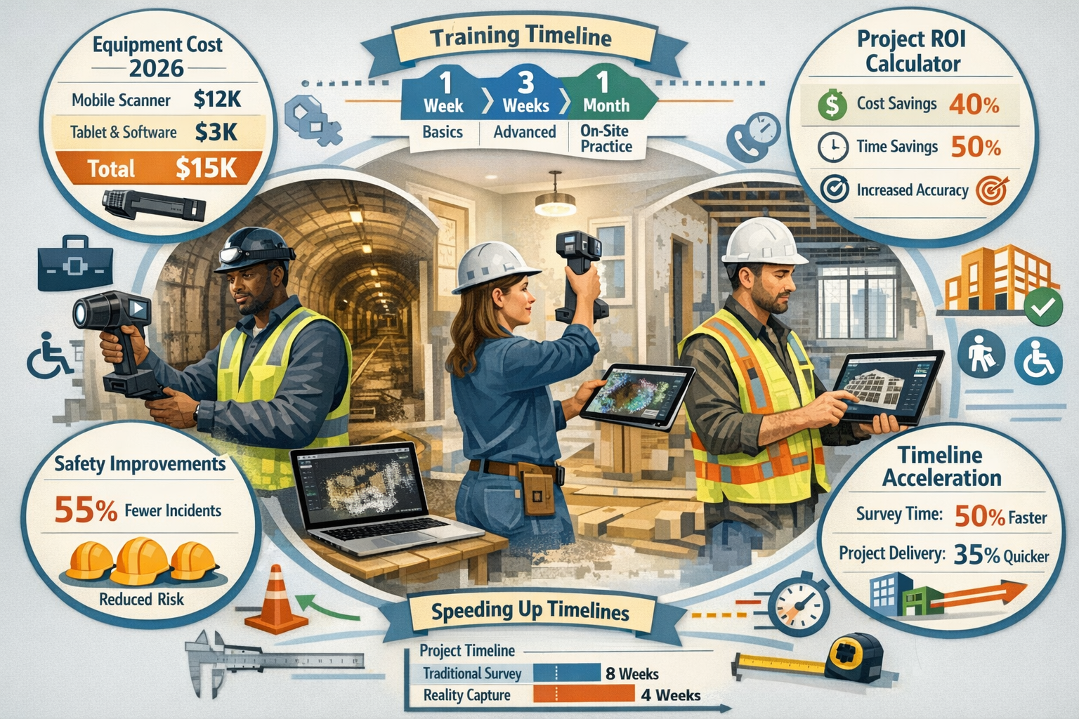
For small surveying firms considering reality capture adoption, understanding the true cost structure is essential. While equipment represents the most visible investment, the total cost of ownership includes several components:
Equipment Investment (2026 Pricing):
| System Type | Price Range | Best For |
|---|---|---|
| Entry-level handheld SLAM | £8,000 – £15,000 | Small residential surveys, inspections |
| Mid-range mobile mapping | £15,000 – £35,000 | Commercial surveys, construction documentation |
| Professional static TLS | £25,000 – £60,000 | High-precision control, mechanical systems |
| Hybrid system package | £40,000 – £80,000 | Full-service surveying firms |
Operational Costs:
- Software licenses: £1,200 – £5,000 annually for processing and modeling software
- Training: £2,000 – £5,000 for initial certification and ongoing education
- Data storage: £500 – £2,000 annually for cloud storage and backup systems
- Maintenance: 5-10% of equipment cost annually for calibration and repairs
The ROI Calculation:
Mobile capture costs 50-70% less in field acquisition time compared to traditional methods.[4] However, the "noisier" data can increase Scan-to-BIM modeling costs by approximately 20%, requiring strategic tool selection based on project requirements.[4]
For a small firm conducting 50 surveys annually:
- Traditional method: 2 days field time × £800/day = £80,000 annual field costs
- Mobile capture: 0.5 days field time × £800/day = £20,000 annual field costs
- Annual savings: £60,000 (before accounting for processing costs)
Even with increased processing time, most small firms achieve full ROI within 12-18 months of adoption.
Building Your Implementation Roadmap
Successfully implementing reality capture technology requires a structured approach. Here's a practical roadmap for small firms:
Phase 1: Assessment and Planning (Weeks 1-4)
📋 Evaluate current workflow
Document time spent on typical projects, identify bottlenecks, and calculate baseline costs for comparison.
🎯 Define use cases
Identify which survey types will benefit most from reality capture. Start with projects that have tight timelines or difficult access requirements.
💼 Budget allocation
Determine equipment budget, training investment, and software requirements. Consider leasing options for initial trials.
Phase 2: Equipment Selection and Acquisition (Weeks 5-8)
🔍 Research and demo
Request demonstrations from multiple vendors, test equipment on actual project sites, and compare workflows.
📊 Compare specifications
Match equipment capabilities to your identified use cases. Don't over-invest in precision you don't need.
✅ Purchase or lease
Make acquisition decision based on ROI projections and cash flow considerations.
Phase 3: Training and Skill Development (Weeks 9-12)
👨🏫 Formal training
Invest in manufacturer training programs and industry certifications. Many vendors offer free or discounted training with equipment purchase.
🏗️ Practice projects
Conduct trial scans on internal projects or friendly client sites before billing for reality capture services.
📚 Documentation
Create internal procedures, checklists, and quality control protocols specific to your firm's workflow.
Phase 4: Pilot Projects (Months 4-6)
🚀 Select appropriate projects
Choose projects with flexible timelines and clients open to new technology adoption.
⚖️ Hybrid approach
Use reality capture alongside traditional methods initially to verify accuracy and build confidence.
📈 Track metrics
Document time savings, accuracy improvements, and client satisfaction for ROI validation.
Phase 5: Full Integration (Months 7-12)
🔄 Workflow optimization
Refine processes based on pilot project learnings and eliminate redundant traditional methods.
💰 Pricing adjustment
Update service pricing to reflect new capabilities and efficiency gains while remaining competitive.
📣 Marketing and differentiation
Promote reality capture capabilities to attract clients seeking advanced documentation and faster turnaround.
Overcoming Common Implementation Challenges
Challenge 1: Staff Resistance to Change
Many experienced surveyors initially resist new technology, preferring familiar traditional methods. Address this by:
- Involving staff in equipment selection and testing
- Highlighting how technology reduces physical strain and safety risks
- Demonstrating career advancement opportunities with new skills
- Starting with enthusiastic early adopters as internal champions
Challenge 2: Data Management and Storage
Point cloud datasets can be massive (50-500GB per project). Solutions include:
- Cloud-based storage with automatic backup (£500-2,000 annually)
- Local NAS (Network Attached Storage) systems for cost-effective archiving
- Data retention policies that delete raw scans after final deliverables
- Progressive file formats that reduce storage requirements
Challenge 3: Client Education
Clients unfamiliar with reality capture may not understand its value. Effective strategies include:
- Visual demonstrations showing point cloud walkthroughs
- Case studies highlighting time and cost savings
- Offering reality capture as value-added service initially
- Providing multiple deliverable formats (traditional drawings plus 3D models)
Challenge 4: Quality Control and Accuracy Verification
Ensuring scan quality requires new QC procedures:
- Establish scan overlap protocols (minimum 30% between positions)
- Use survey control targets for verification
- Implement checklist systems for field data collection
- Conduct peer reviews of processed data before client delivery
Meeting Industry Standards with Mobile Technology
A critical consideration for professional surveyors is whether mobile SLAM technology meets industry accuracy standards. The answer in 2026 is increasingly "yes" for most applications.
Mobile SLAM meets BOMA 2026 standards: Mobile LiDAR, accurate to approximately 20mm (under 1 inch), satisfies BOMA (Building Owners and Managers Association) 2026 standards for rentable area calculations, enabling capture of 500,000+ sq. ft. buildings in days rather than weeks.[4]
For monitoring surveys and specific defect reports, the 15-20mm accuracy of mobile systems exceeds the requirements for documenting structural movement, crack propagation, and settlement patterns.
However, applications requiring survey-grade precision—such as solid floor slab surveys for flatness verification—still benefit from static TLS with its 1.9mm accuracy.[4]
Advanced Applications and Future Capabilities
Beyond Line of Sight: Context-Rich Models
The next frontier in reality capture extends beyond visible surfaces to capture subsurface and contextual information. Industry leaders are advocating for laser scanning to go "beyond line of sight" by adding attribute data layers such as rebar depth, concrete thickness, conduit placement under slabs, and wall thickness, creating context-rich models that show both visible and subsurface infrastructure.[1]
Emerging Integration Technologies:
🔍 Ground Penetrating Radar (GPR)
Combines with laser scanning to map utilities, rebar, and voids beneath surfaces during the same data collection session.
🌡️ Thermal Imaging
Overlays temperature data onto 3D models to identify insulation gaps, moisture intrusion, and HVAC inefficiencies.
📸 High-Resolution Photography
Creates photorealistic textures on 3D models for visual documentation and defect identification.
📡 IoT Sensor Integration
Embeds real-time monitoring data (vibration, temperature, humidity) into digital twin models for ongoing facility management.
These integrated approaches transform reality capture from simple geometric documentation into comprehensive facility intelligence systems.
BIM and Digital Twin Integration
The increasing adoption of BIM and digital twin technologies, which rely heavily on accurate 3D data from mobile laser scanning, is significantly boosting market demand, particularly in infrastructure management and asset monitoring for aging infrastructure.[5]
Reality Capture in the BIM Workflow:
- Existing Conditions Documentation: Scan existing buildings before renovation design
- Design Verification: Compare as-built conditions to design models
- Construction Progress Tracking: Regular scans document construction advancement
- Quality Control: Identify deviations from design specifications
- Facility Management: Create as-built models for ongoing maintenance and operations
For firms offering residential structural engineering services, reality capture enables precise documentation of existing conditions before structural modifications, reducing design errors and construction surprises.
Expanding into New Market Sectors
As devices become more affordable and easier to use, even small firms and individual contractors are expected to adopt the technology, expanding access beyond large enterprises.[2] This democratization is opening new market opportunities:
Insurance and Claims Documentation 📋
Rapid documentation of damage for insurance claims, providing indisputable evidence of pre-loss and post-loss conditions.
Real Estate and Property Marketing 🏘️
Virtual tours and accurate floor plans enhance property listings and reduce time-to-sale.
Heritage and Historical Preservation 🏛️
Detailed documentation of historical structures for preservation, restoration, and educational purposes.
Forensic Investigation 🔎
Crime scene and accident reconstruction with precise spatial relationships and measurements.
Facility Management 🏢
Ongoing documentation of building changes, equipment installations, and space utilization for large portfolios.
Disaster Response and Emergency Management 🚨
Rapid assessment of structural damage after earthquakes, floods, or fires to inform safety decisions.
Safety Improvements Through Remote Capture
One of the most compelling benefits of reality capture technology is the dramatic improvement in surveyor safety. Traditional surveying often requires access to dangerous locations—rooftops, confined spaces, unstable structures, and active construction zones.
Safety Benefits:
✅ Reduced height work: Scan from ground level instead of climbing
✅ Confined space avoidance: Capture data without entering hazardous areas
✅ Active zone documentation: Scan without entering operational areas
✅ Unstable structure assessment: Evaluate damage without physical access
✅ Reduced site visits: Comprehensive single-visit capture minimizes exposure
For roof surveys and schedule of dilapidations work, reality capture enables comprehensive documentation while keeping surveyors safely on the ground.
Real-World Success Stories
Small Firm Case Study: Regional Surveying Practice
A three-person surveying firm in Southeast England invested £18,000 in a mid-range handheld SLAM system in early 2025. Within 12 months:
- Field time reduced by 65% on commercial surveys
- Project capacity increased from 4 to 9 surveys monthly
- Revenue increased by 85% without additional staff
- Client satisfaction scores improved due to faster turnaround
- Won contracts previously going to larger competitors
Construction Documentation Case Study: Airport Terminal Renovation
A major airport required comprehensive as-built documentation of a 300,000 sq. ft. terminal while maintaining full operations. Using mobile SLAM technology:
- Captured entire terminal in 3 days (vs. 4-6 weeks traditional)
- Minimal disruption to passenger operations
- Delivered accurate BIM model for renovation design
- Identified 47 conflicts between design and existing conditions before construction
- Saved estimated £250,000 in construction change orders
Selecting the Right Technology for Your Needs
Decision Framework for Equipment Selection
Choosing appropriate reality capture technology requires matching capabilities to your specific survey requirements. Use this decision framework:
Question 1: What accuracy do you need?
- Survey-grade (<5mm): Static TLS required
- Construction documentation (10-20mm): Mobile SLAM sufficient
- Area calculations and general documentation (20-50mm): Entry-level mobile systems adequate
Question 2: What environments will you scan?
- Outdoor, GPS available: GPS-assisted mobile mapping
- Indoor, GPS-denied: SLAM-based systems essential
- Mixed environments: Hybrid system or SLAM with control targets
Question 3: What is your typical project size?
- Small residential (<3,000 sq. ft.): Handheld SLAM
- Medium commercial (3,000-50,000 sq. ft.): Professional mobile mapping
- Large facilities (>50,000 sq. ft.): Hybrid static + mobile approach
Question 4: What are your deliverable requirements?
- 2D floor plans only: Basic mobile scanning sufficient
- 3D BIM models: Professional-grade systems with modeling software
- Photorealistic visualization: Systems with integrated photography
- Ongoing monitoring: Systems with registration and comparison capabilities
Question 5: What is your budget?
- Under £15,000: Entry-level handheld systems
- £15,000-£40,000: Professional mobile mapping systems
- £40,000-£80,000: Hybrid static + mobile capabilities
- £80,000+: Enterprise-level multi-technology platforms
Software Ecosystem Considerations
Hardware is only half the equation. The software ecosystem determines how efficiently you can process data and deliver client-ready results.
Essential Software Categories:
1. Registration and Processing
Aligns multiple scans, removes noise, and creates unified point clouds. Most hardware manufacturers include basic software with equipment purchase.
2. Point Cloud Viewing and Markup
Enables measurement, annotation, and client sharing of scan data. Free viewers are available, while professional tools cost £500-2,000 annually.
3. Scan-to-BIM Modeling
Converts point clouds into intelligent 3D models. Costs range from £2,000-8,000 annually depending on features and automation level.
4. CAD Integration
Plugins that enable point cloud import into AutoCAD, Revit, and other design platforms. Usually £500-1,500 per license.
5. Cloud Collaboration
Web-based platforms for client access, project management, and team collaboration. Subscription costs typically £50-200 monthly.
Many firms initially underestimate software costs, which can equal or exceed hardware expenses over a 5-year period. Factor these ongoing costs into your ROI calculations.
Training and Certification Pathways
Professional competency in reality capture requires both technical skills and surveying knowledge. Several certification pathways exist in 2026:
Manufacturer Certifications
Equipment manufacturers offer training programs ranging from 2-day basic operation courses (£500-1,500) to advanced certification programs (£3,000-5,000). These provide equipment-specific expertise and often include ongoing support.
Industry Certifications
Professional organizations offer vendor-neutral certifications that demonstrate competency across platforms and applications. These carry more weight with clients and typically require 40-80 hours of training plus examination.
Academic Programs
Universities and technical colleges now offer diploma and degree programs incorporating reality capture technology. These provide comprehensive theoretical foundation alongside practical skills.
Online Learning
Numerous online platforms offer self-paced courses ranging from free introductory content to professional development programs costing £500-2,000.
Recommended Learning Path for Small Firms:
- Manufacturer basic training (2-3 days): Learn equipment operation and basic workflows
- Online supplementary courses (20-40 hours): Develop processing and modeling skills
- Mentorship or consulting (ongoing): Engage experienced practitioners for project-specific guidance
- Industry certification (6-12 months): Pursue formal certification after gaining practical experience
Regulatory Compliance and Professional Standards
Meeting Professional Surveying Standards
As reality capture becomes mainstream, professional surveying organizations have developed standards and guidelines for technology application. In the UK, the Royal Institution of Chartered Surveyors (RICS) has published guidance on laser scanning and reality capture for different types of surveys.
Key Standards Considerations:
📏 Accuracy Verification
Document equipment calibration, establish control networks, and verify scan accuracy against known measurements.
📋 Methodology Documentation
Record scanning parameters, equipment settings, and environmental conditions for each project.
🔒 Data Security and Privacy
Implement protocols for protecting client data, particularly when using cloud-based processing and storage.
⚖️ Professional Liability
Ensure professional indemnity insurance covers reality capture services and understand limitations of coverage.
📊 Quality Assurance
Establish internal QA procedures for scan completeness, accuracy verification, and deliverable review.
Data Privacy and GDPR Compliance
Reality capture technology raises unique data privacy considerations. Point clouds and 3D models may inadvertently capture personal information, vehicle registration plates, or sensitive security details.
GDPR Compliance Measures:
- Minimize unnecessary capture: Limit scanning to areas required for project scope
- Blur or redact sensitive information: Remove identifiable details from deliverables
- Secure data storage: Encrypt data in transit and at rest
- Limited retention: Delete raw scan data after project completion
- Client consent: Obtain explicit permission for scanning occupied spaces
For firms conducting surveys in residential settings or occupied commercial buildings, establishing clear data handling protocols protects both clients and the firm from privacy violations.
Insurance and Liability Considerations
Reality capture technology introduces new professional liability considerations that require insurance review:
Coverage Gaps to Address:
- Technology errors and omissions: Coverage for errors in scan data or processing
- Cyber liability: Protection for data breaches or cloud storage compromises
- Equipment damage: Coverage for expensive scanning equipment in field conditions
- Third-party claims: Protection if scan data is used by others and leads to losses
Consult with insurance providers specializing in surveying and engineering professions to ensure adequate coverage. Many insurers now offer specific reality capture endorsements to professional indemnity policies.
The Future of Reality Capture Technology
Emerging Technology Trends
The reality capture landscape continues to evolve rapidly. Several emerging trends will shape the next phase of mainstream adoption:
Artificial Intelligence and Automation 🤖
Machine learning algorithms are increasingly automating scan processing, feature extraction, and model generation. By 2027-2028, AI is expected to reduce post-processing time by 60-80%, further improving project economics.[2]
Smartphone Integration 📱
Consumer devices with LiDAR sensors (already present in high-end smartphones) are becoming capable of professional-quality scanning for smaller projects. This democratization will expand reality capture to property inspectors, estate agents, and homeowners.
Real-Time Processing ⚡
Cloud computing advances enable real-time point cloud processing during data capture, allowing immediate quality verification and eliminating the need for return visits due to data gaps.
Miniaturization 📦
Scanning devices continue to shrink while maintaining accuracy, with some systems now small enough to mount on drones or robotic platforms for fully autonomous capture.
Extended Reality Integration 🥽
Augmented and virtual reality headsets enable immersive visualization of scan data on-site, allowing design overlay and real-time comparison during construction.
Predictions for the Next Decade
Based on current trajectories, the next decade will see:
2026-2028: Consolidation Phase
- Entry-level systems drop below £5,000
- 50%+ of surveying firms adopt some form of reality capture
- Industry standards and best practices become formalized
- Insurance and regulatory frameworks fully accommodate technology
2029-2031: Integration Phase
- Reality capture becomes default methodology for most survey types
- Traditional measurement methods reserved for specialized applications only
- AI-driven automation handles 70%+ of processing workflows
- Smartphone-based capture acceptable for residential surveys
2032-2034: Transformation Phase
- Digital twins become standard for all commercial properties
- Continuous monitoring replaces periodic surveys for many applications
- Reality capture merges with IoT and building automation systems
- Profession evolves toward data analysis rather than data collection
Preparing Your Firm for the Future
To position your surveying practice for long-term success in this evolving landscape:
Invest in Continuous Learning 📚
Technology evolution requires ongoing education. Budget 5-10% of revenue for training and professional development.
Build Technology Partnerships 🤝
Develop relationships with equipment manufacturers, software developers, and technology consultants who can provide guidance as capabilities evolve.
Diversify Service Offerings 🎯
Expand beyond traditional surveying into facility management, construction monitoring, and digital twin development to capture emerging market opportunities.
Embrace Change Management 🔄
Create organizational culture that welcomes technological advancement rather than resisting it. Involve staff in technology decisions and celebrate innovation.
Focus on Value, Not Just Technology 💎
Remember that clients purchase outcomes, not technology. Position reality capture as a means to deliver better results faster, not as an end in itself.
Conclusion
The transformation of reality capture from specialized tool to accessible standard represents one of the most significant developments in surveying history. In 2026, reality capture goes mainstream: implementing 3D laser scanning and mobile mapping for everyday surveys is no longer a future vision—it's current reality for forward-thinking firms of all sizes.
The technology barriers that once limited adoption have largely disappeared. Equipment costs have dropped 70-80% from peak levels, user interfaces have become intuitive enough for rapid onboarding, and processing workflows have streamlined to deliver results in hours rather than weeks. Small surveying firms can now compete with enterprise-level accuracy and efficiency, leveling the competitive playing field.
The benefits extend beyond mere efficiency gains. Reality capture improves surveyor safety by enabling remote documentation of dangerous areas, enhances client satisfaction through faster turnaround and comprehensive deliverables, and opens new market opportunities in sectors previously underserved by traditional surveying methods.
For firms still relying exclusively on traditional methods, the window for competitive advantage through early adoption is closing. However, the window for successful implementation remains wide open. The hybrid workflow approach—combining static scanning for precision control with mobile mapping for rapid data collection—provides a practical entry point that balances investment with capability.
Actionable Next Steps
Ready to implement reality capture in your surveying practice? Follow these concrete steps:
Immediate Actions (This Week):
- ✅ Assess current workflow: Document time and costs for typical projects to establish baseline metrics
- ✅ Identify pilot projects: Select 2-3 upcoming projects suitable for reality capture trial
- ✅ Research equipment options: Request demonstrations from 3-4 vendors matching your budget and requirements
Short-Term Actions (This Month):
- ✅ Attend demonstrations: Test equipment on actual project sites to evaluate real-world performance
- ✅ Calculate ROI: Project costs, savings, and payback period based on your specific project mix
- ✅ Review insurance coverage: Consult with insurance provider about technology-specific coverage needs
Medium-Term Actions (Next Quarter):
- ✅ Make acquisition decision: Purchase or lease equipment based on ROI analysis and budget availability
- ✅ Complete training: Invest in manufacturer and industry training for key staff members
- ✅ Execute pilot projects: Implement reality capture on selected projects while documenting lessons learned
Long-Term Actions (Next Year):
- ✅ Refine workflows: Optimize processes based on pilot project experience and eliminate redundancies
- ✅ Update marketing: Promote new capabilities to existing and prospective clients
- ✅ Expand applications: Explore new market sectors and service offerings enabled by reality capture
The surveying profession stands at a pivotal moment. Those who embrace reality capture technology position themselves for growth, competitive advantage, and professional relevance in an increasingly digital built environment. Those who delay risk obsolescence as clients increasingly expect the speed, accuracy, and comprehensive documentation that only reality capture can deliver.
The question is no longer whether to adopt reality capture, but how quickly you can implement it effectively. The technology is ready. The market is demanding it. The only remaining variable is your decision to act.
For firms seeking guidance on implementing reality capture alongside traditional chartered surveying services, professional consultation can accelerate successful adoption while avoiding common pitfalls. The future of surveying is here—and it's more accessible than ever before.
References
[1] What Is The Future Of 3d Laser Scanning – https://www.gp-radar.com/article/what-is-the-future-of-3d-laser-scanning
[2] Future Trends In 3d Laser Scanning What To Expect In The Next Decade – https://mapp3dsolutions.com/future-trends-in-3d-laser-scanning-what-to-expect-in-the-next-decade/
[3] Benefits Of 3d Laser Scanning – https://eagle-eac.com/benefits-of-3d-laser-scanning/
[4] 3d Laser Scanning Vs Lidar Differences – https://iscano.com/laser-scanning-lidar-technology/3d-laser-scanning-vs-lidar-differences/
[5] Mobile Laser Scan Systems 46668 – https://www.datainsightsmarket.com/reports/mobile-laser-scan-systems-46668