The land surveying industry stands at a transformative crossroads in 2026. What once required weeks of manual measurements, multiple site visits, and painstaking data analysis now happens in real time through autonomous systems. Revolutionizing Land Surveying: How AI and Machine Learning Are Predicting Risks and Automating Workflows in 2026 represents more than technological advancement—it marks a fundamental shift in how professionals assess, analyze, and protect our built and natural environments. As infrastructure demands surge globally and climate-related risks intensify, AI-powered surveying tools have emerged from experimental labs into everyday practice, delivering unprecedented accuracy while dramatically reducing costs and timelines.
The transformation is profound. Surveyors who once spent days establishing control points and processing data now deploy autonomous drones that capture hundreds of acres in a single flight, with machine learning algorithms instantly classifying terrain features and flagging potential risks. This revolution touches every aspect of the profession, from boundary delineations to disaster prediction, making advanced surveying capabilities accessible to firms of all sizes.
Key Takeaways
📊 Real-time processing has replaced multi-day timelines, with AI-enhanced sensors capturing and analyzing survey data instantly during drone flights and mobile mapping operations.
🎯 Centimeter-level accuracy is now standard through AI-powered drones and self-calibrating instruments that automatically detect and correct data anomalies.
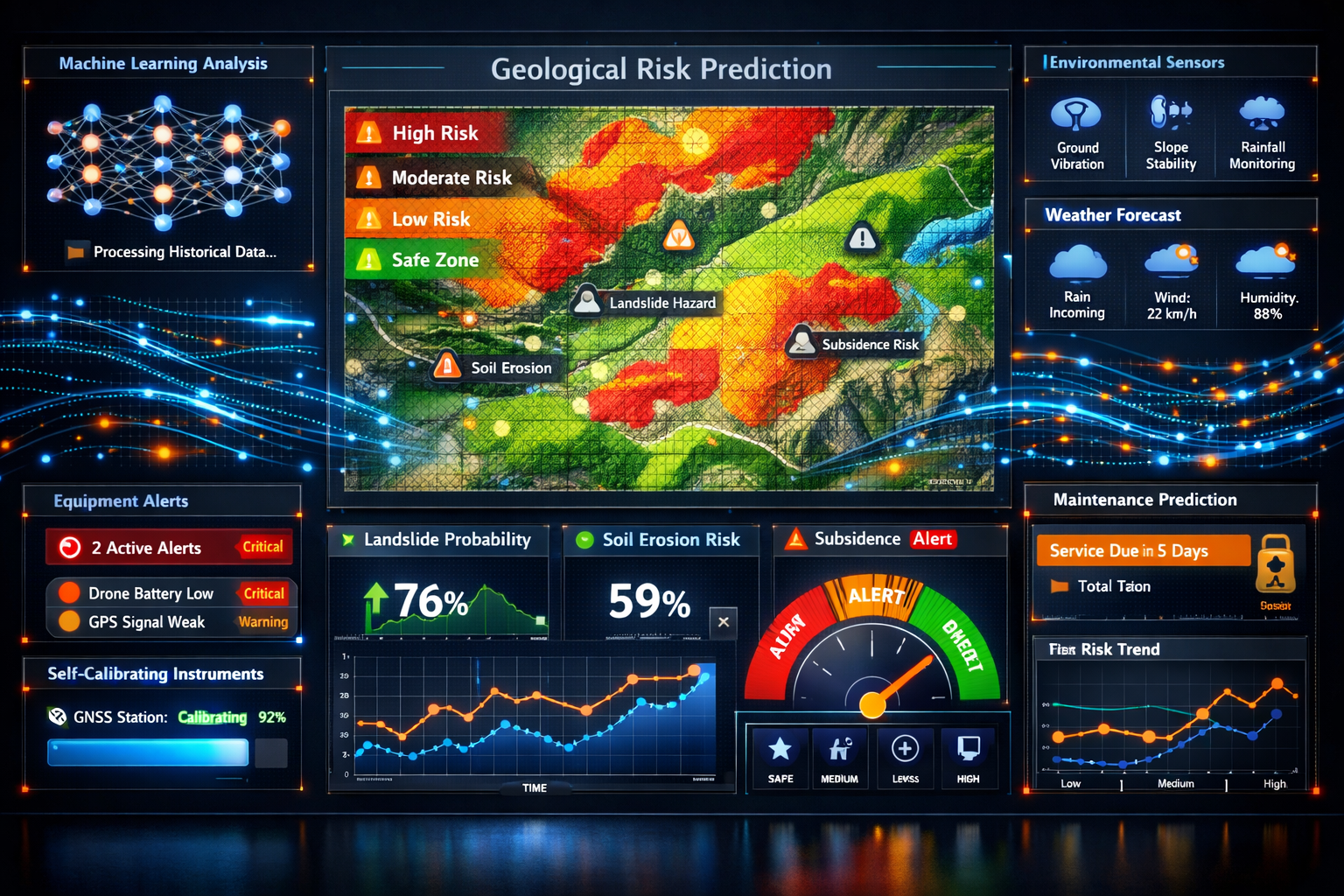
🔮 Predictive analytics anticipate geological risks including soil erosion, landslides, and ground subsidence by analyzing historical survey data combined with environmental factors.
💰 Cost and time reductions of up to 70% make advanced surveying technology accessible to smaller firms through automated workflows and reduced labor requirements.
🛡️ Preventive maintenance powered by AI sensors monitors equipment performance in real time, preventing costly failures and extending instrument lifespan.
The Evolution from Traditional to AI-Enhanced Surveying Workflows
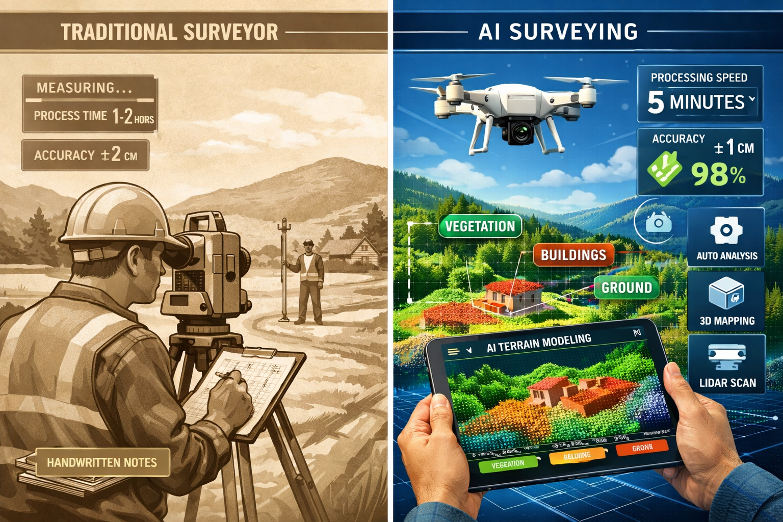
Traditional land surveying relied heavily on manual processes that demanded significant time, labor, and expertise. Surveyors would establish control points, take measurements with theodolites and total stations, record data by hand or in basic digital formats, then spend days processing information to create usable maps and reports. This methodology, while proven over centuries, created bottlenecks that limited project scope and increased vulnerability to human error.
The integration of AI and machine learning has fundamentally altered this workflow[1]. Modern surveying systems now embed artificial intelligence directly into core operations rather than treating it as an add-on feature. Instead of manual data sorting and classification, AI systems instantly identify terrain types, locate survey markers, detect anomalies, and generate preliminary surface models without human intervention[1].
How AI Transforms Daily Surveying Operations
The practical impact becomes clear when examining specific workflow improvements:
Automated Data Classification: Machine learning algorithms analyze LiDAR point clouds to distinguish between vegetation, buildings, power lines, water features, and bare earth terrain[3]. What previously required hours of manual point cloud editing now happens automatically during data capture, with AI achieving classification accuracy rates exceeding 95% in most conditions.
Intelligent Flight Planning: Autonomous drones utilize predictive modeling to plan optimal flight paths before takeoff[1]. The AI considers terrain complexity, required accuracy levels, weather conditions, and battery limitations to determine the most efficient survey pattern. During flight, the system automatically adjusts altitude, camera angles, and sensor selection to achieve optimal readings.
Self-Calibrating Instruments: Modern surveying equipment incorporates AI-enabled self-calibration capabilities[3]. Total stations, GNSS receivers, and laser scanners continuously monitor their own performance, detecting drift or errors and making automatic corrections. This reduces setup time and virtually eliminates calibration-related measurement errors that plagued traditional instruments.
For professionals conducting structural surveys, these automated workflows mean more comprehensive data collection with fewer site visits, translating directly into better risk assessment and client value.
Real-Time Processing Replaces Multi-Day Timelines
Perhaps the most dramatic change involves processing speed. Traditional surveying for projects like road construction or land development required days or weeks to gather sufficient data, followed by additional processing time before results became available[3]. This delay created project bottlenecks and prevented rapid decision-making.
AI-enhanced sensors and machine learning now enable real-time data processing[3]. As drones capture aerial imagery or mobile mapping vehicles scan roadways, onboard AI systems simultaneously process the information, generating preliminary maps and identifying issues while still in the field. Survey teams can verify coverage completeness, identify data gaps, and make immediate adjustments—all during the same site visit.
| Traditional Surveying Timeline | AI-Enhanced Surveying Timeline |
|---|---|
| Site reconnaissance: 1-2 days | Automated flight planning: 30 minutes |
| Data collection: 3-5 days | Single-flight data capture: 2-4 hours |
| Data processing: 5-7 days | Real-time processing during flight |
| Quality control: 2-3 days | Automated QC with instant flagging |
| Final deliverables: 2-3 days | Same-day preliminary deliverables |
| Total: 13-20 days | Total: 1-2 days |
This acceleration proves particularly valuable for time-sensitive projects and when conducting homebuyer surveys where quick turnaround directly impacts transaction timelines.
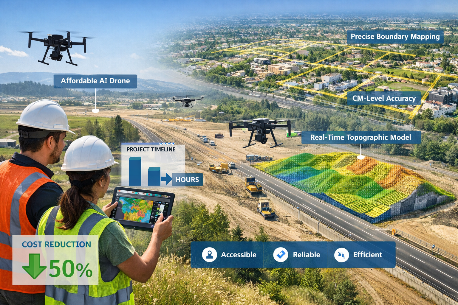
Single-Flight Comprehensive Surveys
The combination of AI planning and real-time processing enables single-flight surveys that capture what previously required multiple site visits[3]. AI-enhanced UAVs can survey hundreds of acres in one flight, generating detailed topographic data processed instantly. The system automatically identifies areas requiring additional coverage and adjusts the flight path accordingly—all without operator intervention.
This capability transforms large-area surveying economics. A project that once required a crew of three surveyors working for two weeks can now be completed by one operator in a single day, with comparable or superior accuracy. The cost savings extend beyond labor to include reduced equipment deployment, transportation, and accommodation expenses for multi-day field campaigns.
Revolutionizing Land Surveying: How AI and Machine Learning Are Predicting Risks and Automating Workflows in 2026 Through Advanced Pattern Recognition
Beyond workflow automation, AI brings unprecedented capabilities in pattern recognition and risk prediction—areas where human analysis faces inherent limitations when processing massive datasets. Machine learning algorithms excel at identifying subtle patterns across millions of data points, detecting relationships that would remain invisible to manual analysis.
Predictive Analytics for Geological Hazards
One of the most valuable applications involves predicting geological risks before they manifest as disasters[3]. AI models analyze historical survey data combined with environmental factors—rainfall patterns, soil composition, vegetation changes, and seismic activity—to forecast events such as:
-
Soil erosion: Machine learning identifies areas where topographic features, soil types, and water flow patterns create high erosion risk, allowing preventive measures before significant land loss occurs.
-
Landslide susceptibility: By analyzing slope angles, soil moisture, vegetation cover, and historical movement data, AI systems generate probability maps showing landslide-prone zones with remarkable accuracy.
-
Ground subsidence: Algorithms detect subtle elevation changes over time that indicate subsidence risk, particularly valuable in areas with underground mining, groundwater extraction, or compressible soils.
These predictive capabilities prove invaluable for infrastructure planning, property development, and disaster preparedness. When conducting drainage surveys, AI-enhanced analysis can predict future drainage issues based on terrain evolution patterns, enabling proactive design modifications.
"AI models analyze historical survey data combined with environmental factors to predict events such as soil erosion, landslides, or ground subsidence, transforming reactive surveying into proactive risk management."
Environmental Change Detection at Unprecedented Scales
Survey equipment integrated with AI can detect small-scale environmental changes that signal larger trends[3]. This capability supports crucial monitoring for:
-
Deforestation tracking: Automated comparison of multi-temporal survey data identifies vegetation loss down to individual tree level, providing early warning of illegal logging or habitat degradation.
-
Desertification monitoring: AI algorithms analyze vegetation density, soil moisture indicators, and terrain changes to quantify desertification progression and evaluate mitigation effectiveness.
-
Water resource depletion: Machine learning processes elevation data around water bodies, detecting shoreline recession and volume changes that indicate aquifer depletion or drought impact.
These applications extend surveying's role beyond traditional boundary and topographic work into environmental stewardship and climate change monitoring—areas of growing importance and commercial opportunity.
Pattern Recognition in Complex Terrain Features
AI excels at identifying and classifying complex terrain features within massive point cloud datasets[3]. LiDAR surveys generate millions of individual points, each representing a precise location in three-dimensional space. Manually classifying these points—separating ground from vegetation, identifying building footprints, or locating utility infrastructure—represents an enormous time investment.
Machine learning algorithms trained on labeled datasets can automatically classify point clouds with impressive accuracy:
-
Vegetation classification: AI distinguishes between different vegetation types (trees, shrubs, grass) and heights, valuable for forestry applications and environmental assessments.
-
Building extraction: Algorithms automatically identify building footprints and roof structures, generating 3D building models directly from point cloud data.
-
Infrastructure detection: AI locates power lines, poles, roads, and other infrastructure elements, creating comprehensive asset inventories from aerial surveys.
The accuracy and speed of these automated classifications dramatically reduce human error and processing time, allowing surveyors to focus on interpretation and decision-making rather than tedious data manipulation.
Implementing AI-Powered Surveying: Practical Considerations and Case Studies
Understanding the theoretical benefits of Revolutionizing Land Surveying: How AI and Machine Learning Are Predicting Risks and Automating Workflows in 2026 matters less than knowing how to implement these technologies effectively. Successful adoption requires addressing practical considerations around equipment selection, training, workflow integration, and quality control.
Equipment and Technology Stack Selection
The foundation of AI-enhanced surveying lies in selecting appropriate hardware and software combinations. In 2026, the market offers numerous options across price points, making the technology accessible to firms of varying sizes.
Drone Platforms: Modern survey drones range from entry-level systems under $5,000 to professional-grade platforms exceeding $50,000. Key AI-related features to evaluate include:
- Autonomous flight capabilities with obstacle avoidance
- Onboard processing power for real-time data analysis
- Sensor payload capacity (RGB cameras, multispectral, LiDAR)
- Battery life and coverage area per flight
- Integration with AI processing software
Ground-Based Systems: Total stations and laser scanners increasingly incorporate AI features:
- Self-leveling and self-calibration routines
- Automated target recognition and tracking
- Real-time data quality assessment
- Cloud connectivity for immediate data upload
Software Platforms: AI-powered processing software represents the intelligence layer that transforms raw data into actionable information. Leading platforms offer:
- Automated point cloud classification
- Machine learning-based feature extraction
- Predictive modeling for risk assessment
- Integration with CAD and GIS systems
- Cloud-based processing for handling massive datasets
For firms conducting RICS building surveys, integrating AI-powered drones with traditional inspection methods creates comprehensive assessment capabilities that exceed what either approach achieves independently.
Training and Skill Development
Implementing AI surveying technology requires developing new competencies within surveying teams. The skill set extends beyond traditional surveying knowledge to include:
Data Science Fundamentals: Understanding how machine learning algorithms work, their limitations, and appropriate applications helps surveyors make informed decisions about when to trust automated outputs versus applying human judgment.
Drone Operation: Obtaining necessary certifications and developing proficiency in autonomous flight systems, including emergency procedures and manual override capabilities.
Software Proficiency: Mastering AI-powered processing platforms, including parameter adjustment, quality control workflows, and output customization.
Interpretation Skills: Developing expertise in evaluating AI-generated results, identifying potential errors, and knowing when additional verification is necessary.
Many successful firms adopt a hybrid approach, pairing experienced surveyors with technology specialists who collaborate on projects. This combines deep domain knowledge with technical expertise, ensuring AI tools enhance rather than replace professional judgment.
Real-World Implementation: Case Studies
Case Study 1: Large-Scale Infrastructure Project
A highway expansion project covering 50 kilometers required comprehensive topographic surveying and environmental assessment. Traditional methods would have required:
- 6-person crew working 8 weeks for data collection
- Additional 4 weeks for processing and deliverables
- Estimated cost: $180,000
Using AI-enhanced surveying:
- 2-person crew completed data collection in 10 days using autonomous drones
- Real-time processing provided preliminary data during collection
- Final deliverables completed within 2 weeks of project start
- Actual cost: $65,000
- Savings: 64% cost reduction, 70% time reduction
Additionally, AI analysis identified three previously undetected landslide-risk zones, allowing design modifications that prevented potential future failures.
Case Study 2: Flood Risk Assessment
A municipal government needed flood risk mapping for 200 square kilometers to guide development planning. AI-powered surveying delivered:
- High-resolution elevation data captured in 15 flight days
- Machine learning analysis of historical flood data, current topography, and climate projections
- Predictive modeling showing flood probability zones under various scenarios
- Automated identification of critical infrastructure at risk
The AI system detected subtle elevation changes indicating previous flood extents that weren't documented in historical records, improving model accuracy. The predictive capabilities allowed planners to restrict development in high-risk zones and prioritize flood mitigation investments.
Case Study 3: Small Firm Adoption
A three-person surveying firm specializing in residential structural engineering invested in entry-level AI-enhanced drone technology:
- Initial investment: $8,500 (drone + software subscription)
- Training time: 40 hours over 2 months
- First-year project capacity increase: 40%
- Average project completion time reduction: 55%
- Client satisfaction improvement through faster turnaround and more comprehensive data
The technology particularly enhanced their solid floor slab survey capabilities, allowing non-invasive assessment of large areas that previously required extensive manual investigation.
Quality Control and Validation Protocols
While AI dramatically improves efficiency and capabilities, implementing robust quality control protocols remains essential. Best practices include:
Ground Truth Verification: Regularly comparing AI-generated measurements against traditional survey methods to validate accuracy and identify systematic errors.
Redundancy Checks: Collecting overlapping data from multiple sensors or flight paths, allowing cross-validation of results.
Human Review of Critical Decisions: Establishing clear protocols for which AI outputs require professional review before acceptance, particularly for boundary determinations and risk assessments with legal or safety implications.
Continuous Model Improvement: Using identified errors to retrain machine learning models, progressively improving accuracy over time.
Documentation Standards: Maintaining detailed records of AI processing parameters, software versions, and validation results to support professional liability requirements.
These protocols ensure AI enhances rather than compromises professional standards, a critical consideration when conducting work subject to regulatory oversight or potential legal scrutiny.
Cost-Benefit Analysis: Economic Impact of AI Surveying Technology
The financial implications of Revolutionizing Land Surveying: How AI and Machine Learning Are Predicting Risks and Automating Workflows in 2026 extend beyond simple cost reduction. Understanding the complete economic picture helps firms make informed investment decisions and position themselves competitively.
Direct Cost Reductions
Labor Efficiency: AI drones survey large areas in a fraction of the time required by ground crews, reducing manual labor needs[2]. Projects that once required three-person teams for weeks now need single operators for days, creating labor cost savings of 60-75% on data collection.
Equipment Utilization: Automated workflows allow existing equipment to handle higher project volumes. Self-calibrating instruments reduce setup time by 40-50%, enabling crews to complete more work per day with the same equipment investment.
Reduced Rework: Automated quality control and real-time data validation dramatically reduce costly rework from measurement errors or incomplete coverage. Firms report rework reduction of 70-80% after implementing AI-enhanced workflows.
Travel and Accommodation: Single-visit comprehensive surveys eliminate multi-day field campaigns requiring accommodation and per diem expenses, particularly significant for remote project locations.
Revenue Enhancement Opportunities
Expanded Service Offerings: AI capabilities enable firms to offer new services previously beyond their capacity:
- Environmental monitoring and change detection
- Predictive risk assessment and disaster planning
- Large-area surveys previously only accessible to major firms
- Rapid emergency response surveying
Faster Project Turnaround: Reduced completion times allow firms to handle higher project volumes with existing staff, directly increasing revenue capacity without proportional cost increases.
Competitive Differentiation: Offering AI-enhanced services with faster turnaround and more comprehensive deliverables creates competitive advantages that support premium pricing.
Market Expansion: Technology accessibility enables smaller firms to compete for projects previously dominated by larger competitors with extensive resources[3].
Return on Investment Timeline
For a typical small-to-medium surveying firm, AI technology investment shows favorable ROI:
| Investment Component | Cost | Timeframe |
|---|---|---|
| Professional-grade AI drone system | $25,000 | One-time |
| Processing software subscription | $3,600/year | Annual |
| Training and certification | $5,000 | One-time |
| Total First-Year Investment | $33,600 |
Projected Benefits (Year 1):
- Project capacity increase: 35%
- Labor cost reduction: $45,000
- New service revenue: $28,000
- Reduced rework costs: $8,000
- Total First-Year Benefit: $81,000
Net First-Year Gain: $47,400
ROI: 141%
Payback Period: 5 months
These figures align with industry reports showing most firms achieve full investment recovery within 6-12 months of AI technology adoption.
Long-Term Economic Considerations
Equipment Longevity: Predictive maintenance powered by AI sensors monitors survey equipment performance in real time, identifying potential failures before they occur[3]. This extends the lifespan of costly instruments like drones, GNSS systems, and LiDAR scanners by 30-40%, reducing long-term capital expenditure.
Competitive Positioning: As AI surveying becomes industry standard, firms without these capabilities face increasing competitive disadvantage. Early adoption creates market position advantages that compound over time.
Regulatory Compliance: Emerging regulations around infrastructure safety and environmental protection increasingly require the comprehensive data and predictive capabilities that AI surveying provides. Early implementation positions firms to meet future requirements without disruptive technology transitions.
Knowledge Asset Development: Machine learning models improve with use, creating proprietary knowledge assets that enhance firm value. Algorithms trained on firm-specific project data become increasingly accurate and valuable over time.
When evaluating surveyor pricing, clients increasingly recognize the value of AI-enhanced capabilities, making cost-benefit analysis favorable from both provider and client perspectives.
Addressing Challenges and Limitations in AI Surveying Implementation
Despite remarkable advantages, Revolutionizing Land Surveying: How AI and Machine Learning Are Predicting Risks and Automating Workflows in 2026 faces legitimate challenges that require thoughtful management. Understanding these limitations enables realistic expectations and appropriate risk mitigation.
Technical Limitations and Edge Cases
Dense Vegetation Challenges: While AI excels at classifying vegetation in point clouds, dense canopy coverage still limits ground surface detection. LiDAR penetration remains physics-constrained, and machine learning cannot extract information that sensors don't capture. Projects in heavily forested areas may still require traditional ground-based supplementation.
Weather Dependencies: Autonomous drone operations face weather limitations including wind speed, precipitation, and visibility constraints. AI cannot overcome these physical limitations, though predictive weather modeling helps optimize scheduling.
Complex Urban Environments: Dense urban areas with tall buildings create GPS signal interference and complex flight path requirements. While AI improves navigation, some environments still require manual piloting or alternative survey methods.
Unusual Terrain Features: Machine learning models trained on common terrain types may struggle with unusual geological features or artificial structures not represented in training data. Human review remains essential for identifying and correcting classification errors in atypical conditions.
Data Security and Privacy Concerns
AI surveying generates massive datasets containing potentially sensitive information about properties, infrastructure, and terrain. Addressing security and privacy requires:
Data Encryption: Implementing end-to-end encryption for data transmission and storage, particularly when using cloud-based processing platforms.
Access Controls: Establishing robust authentication and authorization protocols limiting data access to authorized personnel.
Privacy Compliance: Ensuring compliance with data protection regulations when surveys capture information about private properties or individuals.
Client Confidentiality: Maintaining confidentiality of client project data, particularly important when machine learning models train on multi-client datasets.
Cybersecurity Protocols: Protecting AI systems from potential hacking or data manipulation that could compromise survey accuracy or data integrity.
Professional Liability and Legal Considerations
The introduction of AI into professional surveying raises important liability questions:
Standard of Care: As AI surveying becomes widespread, professional standards evolve. Firms must understand how AI use affects their duty of care and potential liability exposure.
Error Attribution: When AI systems generate incorrect results, determining responsibility between surveyor, software provider, and equipment manufacturer can be complex. Clear contractual language and professional insurance coverage addressing AI use become essential.
Regulatory Compliance: Surveying regulations in many jurisdictions haven't fully adapted to AI technology. Firms must ensure AI-generated surveys meet existing legal requirements for professional certification and documentation.
Documentation Requirements: Maintaining comprehensive records of AI processing parameters, validation procedures, and human review becomes crucial for defending work quality if challenged.
When conducting work like choosing the right property survey, clear communication about AI use and its implications helps manage client expectations and liability exposure.
Skills Gap and Training Requirements
The surveying profession faces a skills gap as technology evolves faster than traditional education programs adapt:
Educational Lag: Many surveying programs still emphasize traditional methods with limited AI and data science content, creating a gap between graduate capabilities and industry needs.
Continuing Education Needs: Practicing surveyors require ongoing training to maintain competency with rapidly evolving AI technologies.
Generational Differences: Younger professionals often possess stronger technology skills but less surveying domain knowledge, while experienced surveyors have deep expertise but may struggle with new technologies.
Talent Competition: As AI skills become valuable across industries, surveying firms compete with higher-paying technology sectors for qualified personnel.
Addressing these challenges requires industry-wide commitment to education, mentorship programs pairing experienced surveyors with technology specialists, and investment in continuous professional development.
Ethical Considerations
AI implementation raises ethical questions requiring thoughtful consideration:
Job Displacement: Automation inevitably reduces demand for certain traditional surveying roles. The industry must address workforce transition through retraining and role evolution rather than simple displacement.
Algorithmic Bias: Machine learning models can perpetuate biases present in training data. Surveyors must understand these risks and implement validation protocols ensuring equitable treatment across different terrain types and geographic areas.
Over-Reliance on Technology: Maintaining professional judgment and critical thinking skills remains essential. The risk of uncritical acceptance of AI outputs requires cultural emphasis on validation and professional skepticism.
Environmental Impact: While AI surveying reduces field time and travel, it increases energy consumption for data processing and storage. Firms should consider sustainability implications in technology deployment decisions.
Future Trends: What's Next for AI in Land Surveying Beyond 2026
The current state of Revolutionizing Land Surveying: How AI and Machine Learning Are Predicting Risks and Automating Workflows in 2026 represents just the beginning of AI's transformation of the surveying profession. Emerging technologies and evolving applications point toward even more dramatic changes ahead.
Integration with Digital Twins and Smart Cities
Digital twin technology—creating virtual replicas of physical environments that update in real time—represents a natural evolution of AI surveying capabilities[5]. Future applications include:
- Continuous surveying through permanent sensor networks feeding AI systems
- Real-time infrastructure monitoring detecting changes immediately
- Predictive maintenance for entire cities based on comprehensive survey data
- Integration of survey data with IoT sensors, traffic patterns, and utility usage
This evolution transforms surveying from periodic snapshots to continuous monitoring, with AI systems detecting and flagging changes as they occur rather than during scheduled surveys.
Advanced Predictive Capabilities
Machine learning models will evolve beyond current risk prediction to enable:
Climate Change Adaptation: AI analysis of long-term survey data combined with climate models to predict infrastructure vulnerability decades in advance, guiding resilient design and strategic retreat from high-risk areas.
Subsurface Prediction: Machine learning algorithms analyzing surface features, geological data, and historical information to predict subsurface conditions without excavation, revolutionizing foundation design and utility planning.
Disaster Response Optimization: Real-time AI analysis during emergencies to guide response efforts, predict secondary hazards, and optimize resource allocation based on rapidly evolving conditions.
Autonomous Survey Networks
The future likely includes networks of autonomous survey systems operating with minimal human intervention[7]:
- Permanent drone stations conducting scheduled surveys automatically
- Self-deploying ground robots for detailed inspection of flagged areas
- Satellite-based AI analysis providing global coverage with local detail
- Coordinated multi-sensor systems optimizing data collection across platforms
These networks will generate continuous data streams far exceeding current survey frequency, enabling detection of subtle changes that current periodic surveys miss.
Quantum Computing Integration
As quantum computing matures, its integration with AI surveying will enable:
- Processing of exponentially larger datasets in real time
- Complex optimization problems solved instantly (optimal sensor placement, flight path planning)
- Advanced simulation capabilities for predictive modeling
- Enhanced machine learning with dramatically faster training cycles
While still emerging, quantum computing represents a potential paradigm shift in processing capabilities that will further accelerate AI surveying evolution.
Democratization and Accessibility
Technology trends point toward increasing accessibility of AI surveying capabilities[3]:
- Smartphone-based surveying apps with AI processing
- Cloud-based platforms eliminating need for expensive local processing hardware
- Open-source AI models reducing software costs
- Simplified interfaces making advanced capabilities accessible to non-specialists
This democratization will expand surveying's reach into applications currently underserved due to cost constraints, from small-scale development to community-led environmental monitoring.
Regulatory Evolution
As AI surveying matures, regulatory frameworks will evolve to address:
- Standards for AI-generated survey accuracy and validation
- Professional certification requirements for AI surveying competency
- Data privacy regulations specific to comprehensive survey datasets
- Liability frameworks clarifying responsibility for AI-assisted professional work
Proactive engagement with regulatory development helps ensure frameworks that protect public interest while enabling innovation.
Conclusion: Embracing the AI Revolution in Land Surveying
Revolutionizing Land Surveying: How AI and Machine Learning Are Predicting Risks and Automating Workflows in 2026 represents far more than incremental improvement—it marks a fundamental transformation in how the profession operates, what services it provides, and the value it delivers to clients and society. The shift from reactive measurement to proactive prediction, from manual processing to automated workflows, and from periodic snapshots to continuous monitoring creates unprecedented capabilities for understanding and managing our physical environment.
The evidence is compelling: AI-enhanced surveying delivers dramatic reductions in cost and time while simultaneously improving accuracy and expanding capabilities. Centimeter-level precision achieved in hours rather than weeks, predictive analytics anticipating geological hazards before they manifest, and comprehensive environmental monitoring at scales previously impossible—these aren't future possibilities but current realities implemented by forward-thinking firms today.
Yet technology alone doesn't guarantee success. Effective implementation requires thoughtful integration of AI capabilities with professional expertise, robust quality control protocols, ongoing training and skill development, and clear understanding of both capabilities and limitations. The most successful firms treat AI as a powerful tool enhancing professional judgment rather than replacing it, combining algorithmic efficiency with human insight to deliver superior outcomes.
Actionable Next Steps for Surveying Professionals
For firms ready to embrace AI-enhanced surveying, consider these concrete steps:
1. Assess Current Capabilities and Needs: Evaluate your current technology stack, typical project types, and competitive positioning to identify where AI implementation delivers maximum value.
2. Start Small and Scale: Begin with manageable pilot projects using entry-level AI technology before committing to comprehensive system overhauls. Learn from initial implementations to guide larger investments.
3. Invest in Training: Allocate resources for team education in AI fundamentals, drone operation, and advanced processing software. Consider partnering experienced surveyors with technology specialists.
4. Develop Quality Control Protocols: Establish clear procedures for validating AI outputs, documenting processing parameters, and determining when human review is required.
5. Engage with Peers and Industry Organizations: Participate in professional associations, conferences, and user groups to learn from others' experiences and stay current with rapidly evolving best practices.
6. Communicate Value to Clients: Educate clients about AI capabilities and benefits, positioning your firm as a technology leader delivering superior value through innovation.
7. Plan for Continuous Evolution: Recognize that AI surveying technology will continue evolving rapidly. Build organizational capacity for ongoing adaptation rather than treating implementation as a one-time project.
For property owners and developers seeking surveying services, understanding AI capabilities enables more informed decisions when choosing the right property survey for your needs. Look for firms demonstrating competency with modern AI-enhanced methods while maintaining rigorous professional standards.
The revolution in land surveying isn't coming—it's here. The question isn't whether AI will transform the profession but how quickly individual firms and professionals will adapt to harness its capabilities. Those who embrace this transformation position themselves to lead the industry's future, delivering unprecedented value while building sustainable competitive advantages. Those who resist risk obsolescence as clients increasingly expect the speed, accuracy, and predictive capabilities that only AI-enhanced surveying provides.
The future of land surveying combines the best of human expertise with the power of artificial intelligence, creating a profession more capable, efficient, and valuable than ever before. That future is now.
References
[1] Future Land Surveying 2026 – https://haller-blanchard.com/future-land-surveying-2026/
[2] Ai Drones For Surveying Enhancing Land Mapping Precision And Efficiency – https://www.arcsurveyors.com/ai-drones-for-surveying-enhancing-land-mapping-precision-and-efficiency/
[3] Ai Impact Analysis On Land Survey Equipment Industry – https://www.marketsandmarkets.com/ResearchInsight/ai-impact-analysis-on-land-survey-equipment-industry.asp
[4] How Technology Is Revolutionizing Land Surveys – https://www.firstchoicesurveying.com/blog/how-technology-is-revolutionizing-land-surveys
[5] How Ai Is Changing The Role Of The Surveyor In Aec – https://www.gim-international.com/content/article/how-ai-is-changing-the-role-of-the-surveyor-in-aec
[6] Watch – https://www.youtube.com/watch?v=mDFbLrhWNdI
[7] Future Of Surveying Technology Unveiled – https://mcclurevision.com/future-of-surveying-technology-unveiled/