The land surveying industry stands at a remarkable turning point. As 2026 unfolds, surveying professionals are witnessing a technological revolution that would have seemed like science fiction just a decade ago. The Future of Land Surveying Technology: Key Trends Shaping 2026 is defined by intelligent drones, artificial intelligence, and mobile mapping systems that deliver unprecedented accuracy while dramatically reducing project timelines and costs.
Traditional surveying methods—while still valuable—are rapidly giving way to advanced digital solutions that capture millions of data points in seconds, process information in real-time, and deliver actionable insights with point-precise accuracy. For property professionals, construction managers, and surveying firms, understanding these emerging technologies isn't just about staying competitive—it's about fundamentally transforming how projects are planned, executed, and delivered.
This comprehensive guide explores the cutting-edge innovations reshaping land surveying in 2026, from drone-based LiDAR systems to AI-powered data analysis, and reveals how these advancements are making professional surveying services more accessible, accurate, and cost-effective than ever before.
Key Takeaways
- Drone technology adoption is surging, with industry projections showing a 70% increase in usage, making aerial surveying more affordable and accessible for projects of all sizes
- AI and machine learning are revolutionizing data processing, enabling surveyors to analyze massive datasets, identify patterns, and predict potential issues before they become critical problems
- 3D laser scanning (LiDAR) captures millions of data points per second, creating highly detailed digital models that transform how professionals approach infrastructure monitoring and property assessment
- Mobile mapping systems are eliminating the need for bulky equipment, allowing surveyors to create detailed 3D models from both indoor and outdoor environments in remarkably short timeframes
- Integrated digital workflows combining cloud platforms, autonomous systems, and real-time modeling are reducing manual work while improving precision across all project types
Understanding the Current State of Land Surveying Technology
The surveying profession has evolved considerably from its origins of chains, compasses, and theodolites. Today's surveyors operate at the intersection of advanced engineering, geospatial science, and cutting-edge technology. The current landscape reflects a transition period where traditional methods coexist with revolutionary digital tools.
Traditional Methods Still in Use
Many surveying projects still rely on proven techniques including:
- Total stations for precise angle and distance measurements
- GPS/GNSS receivers for positioning and control points
- Levels and theodolites for elevation and angular measurements
- Measuring tapes and chains for boundary verification
These conventional approaches remain valuable, particularly for boundary surveys and legal property delineation where established methodologies provide recognized standards.
The Digital Transformation Underway
However, 2026 marks a decisive shift toward fully digital surveying workflows. Modern surveyors increasingly depend on:
- Robotic total stations with remote operation capabilities
- UAV (drone) platforms equipped with multiple sensor types
- Terrestrial and mobile laser scanners for rapid data capture
- Cloud-based processing platforms for collaborative workflows
- Advanced software suites integrating CAD, GIS, and BIM technologies
This transformation is driven by client demands for faster turnaround times, greater accuracy, and more comprehensive deliverables. Property professionals conducting homebuyer surveys or commercial building surveys increasingly expect detailed 3D visualizations and digital reports rather than traditional paper documentation.
Technology Accessibility Improvements
Perhaps most significantly, surveying technology is becoming more democratized and accessible. Handheld sensors are easier to use, reducing barriers to entry for professionals[6]. Equipment costs are declining while capabilities expand, allowing smaller firms to compete with larger organizations on technological sophistication.
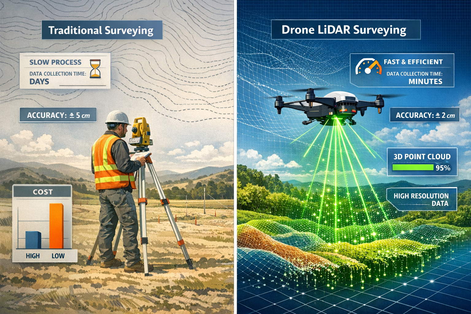
Drone Technology: The Aerial Revolution in Land Surveying
Unmanned Aerial Vehicles (UAVs) represent perhaps the most visible transformation in The Future of Land Surveying Technology: Key Trends Shaping 2026. These flying platforms have moved from experimental novelty to essential surveying tools in remarkably short time.
Explosive Growth in Drone Adoption
Industry projections indicate a 70% increase in drone usage in the surveying sector over the coming years[2]. This dramatic growth stems from several compelling advantages:
- Rapid data collection over large areas
- Access to difficult or dangerous terrain without risk to personnel
- Cost reduction compared to traditional ground-based methods
- High-resolution imagery and topographic data
- Flexibility to revisit sites quickly for monitoring projects
Drones have become significantly cheaper and more accessible[2], with professional-grade systems now available at price points that make economic sense for projects of all sizes. This affordability is democratizing aerial surveying capabilities that were once limited to specialized firms with helicopter or aircraft budgets.
Drone-Based LiDAR: A Game-Changing Innovation
One of the most significant advances is drone-based LiDAR technology, which combines high-resolution laser scanning with aerial imaging capabilities[1]. This integration produces accurate terrain models faster than traditional ground-based methods, with particular advantages in:
- Large-scale topographic surveys covering hundreds of acres
- Complex environments with dense vegetation or challenging access
- Infrastructure corridors such as highways, railways, and pipelines
- Volumetric calculations for mining, quarrying, and earthwork projects
- Forestry applications where ground penetration through canopy is essential
Drone-based LiDAR systems can capture millions of measurement points while simultaneously recording high-resolution imagery, creating comprehensive datasets that support multiple analysis types from a single flight mission.
AI Integration and Automated Analysis
Modern drone platforms increasingly integrate with artificial intelligence for automated data analysis[2]. These intelligent systems can:
- Automatically identify and classify features (buildings, vegetation, water bodies)
- Detect changes between survey periods
- Generate preliminary terrain models without manual intervention
- Flag potential issues or anomalies for human review
- Optimize flight paths for maximum efficiency and coverage
Real-Time Data Collection Capabilities
Advanced drone systems now offer real-time data collection with immediate feedback[2]. Surveyors can view preliminary results in the field, ensuring complete coverage and adequate data quality before leaving the site. This capability eliminates costly return visits and accelerates project timelines significantly.
For professionals conducting structural surveys or roof surveys, drones provide safe inspection of elevated or difficult-to-access areas without scaffolding or specialized access equipment.
Regulatory Considerations
As drone adoption accelerates, regulatory frameworks continue evolving. Surveyors must navigate:
- Aviation authority requirements for commercial drone operations
- Privacy regulations governing aerial photography
- Airspace restrictions near airports and sensitive areas
- Data security protocols for captured information
- Professional liability considerations for drone-derived deliverables
Understanding these regulatory landscapes is essential for firms incorporating UAV technology into their service offerings.
3D Laser Scanning and LiDAR: Precision Modeling at Scale
Three-dimensional laser scanning technology represents another cornerstone of The Future of Land Surveying Technology: Key Trends Shaping 2026. This powerful capability transforms how surveyors capture, process, and deliver spatial information.
How 3D Laser Scanning Works
Laser scanning systems emit rapid pulses of laser light—often millions of data points per second[3]—and measure the time for each pulse to return after reflecting off surfaces. This process creates dense "point clouds" representing the three-dimensional geometry of scanned environments with extraordinary detail.
Modern scanning systems include:
- Terrestrial laser scanners mounted on tripods for stationary scanning
- Mobile mapping systems mounted on vehicles or carried by surveyors
- Aerial LiDAR deployed from drones or aircraft
- Handheld scanners for smaller spaces and detailed work
Creating Highly Detailed Digital Models
The dense point clouds generated by laser scanning enable surveyors to create realistic digital models with point-precise accuracy[3]. These models support:
- As-built documentation of existing structures
- Clash detection in renovation projects
- Volume calculations for materials and earthwork
- Deformation monitoring to track structural movement
- Heritage preservation creating permanent digital records
For specialist defect surveys or damp surveys, laser scanning provides objective dimensional data that supports detailed analysis of structural issues.
Infrastructure Monitoring Applications
3D laser scanning proves particularly valuable for infrastructure monitoring, where it detects structural changes and deformations over time[5]. Regular scanning of bridges, tunnels, dams, and other critical infrastructure reveals:
- Settlement or subsidence patterns
- Structural deflection under load
- Crack propagation and deterioration
- Alignment deviations in transportation corridors
- Erosion or scour around foundations
This monitoring capability enables predictive maintenance strategies, addressing potential failures before they occur rather than reacting to catastrophic events.
Integration with Building Information Modeling
Laser scan data integrates seamlessly with Building Information Modeling (BIM) platforms[3], supporting the entire project lifecycle from initial survey through design, construction, and facility management. This integration enables:
- Scan-to-BIM workflows creating intelligent 3D models from point clouds
- Design verification ensuring as-built conditions match plans
- Coordination between architectural, structural, and MEP systems
- Facility management with accurate spatial data for operations and maintenance
Processing and Analysis Advancements
While laser scanning generates massive datasets, processing capabilities have advanced dramatically. Modern software can:
- Automatically register multiple scans into unified coordinate systems
- Extract features such as walls, floors, and structural elements
- Generate deliverables including plans, sections, and elevations
- Perform measurements directly within point cloud environments
- Create animations and virtual walkthroughs for stakeholder communication
These processing improvements mean that the bottleneck has shifted from data capture to data utilization—surveyors can collect information faster than ever, and increasingly sophisticated tools help extract actionable insights from these rich datasets.
Mobile 3D Mapping: Flexibility and Efficiency Combined
Mobile mapping systems represent a significant evolution in surveying methodology, offering unprecedented flexibility for data collection across diverse environments. This technology is central to understanding The Future of Land Surveying Technology: Key Trends Shaping 2026.
What Makes Mobile Mapping Different
Unlike stationary laser scanners that require setup at multiple positions, mobile mapping systems continuously collect data while in motion. These platforms integrate:
- LiDAR sensors for 3D geometry capture
- High-resolution cameras for imagery and texture
- GNSS receivers for positioning
- Inertial Measurement Units (IMUs) for orientation
- Odometry sensors for precise trajectory calculation
This sensor fusion creates georeferenced point clouds and imagery captured from vehicles, backpacks, or handheld devices.
Creating Detailed Models Without Bulky Equipment
Mobile mapping allows surveyors to create detailed 3D models from indoor and outdoor environments without traditional bulky equipment[1]. The advantages include:
- Rapid data collection covering large areas quickly
- Minimal disruption to ongoing operations
- Comprehensive coverage of complex environments
- Safe data capture from roadways and active sites
- Efficient workflows producing results in short timeframes[1]
For projects requiring stock condition surveys of multiple properties or comprehensive facility documentation, mobile mapping dramatically reduces field time while increasing data completeness.
Vehicle-Based Mobile Mapping
Vehicle-mounted systems excel at corridor mapping applications including:
- Highway and railway surveys
- Utility corridor documentation
- Urban street mapping
- Asset inventory and condition assessment
- Traffic engineering studies
These systems can capture complete roadway environments at normal driving speeds, collecting terabytes of data in single survey sessions that would require weeks using traditional methods.
Backpack and Handheld Systems
Wearable mobile mapping systems extend these capabilities to areas inaccessible to vehicles:
- Building interiors and complex facilities
- Pedestrian areas and parks
- Construction sites and industrial plants
- Underground utilities and tunnels
- Historic sites requiring non-invasive documentation
These portable systems weigh just a few kilograms and can be operated by a single surveyor, making them ideal for projects where traditional equipment setup would be impractical.
Increasing Flexibility and Efficiency
Mobile mapping systems are becoming more flexible and efficient for data collection[1], with recent improvements including:
- Extended battery life for longer survey sessions
- Improved SLAM algorithms (Simultaneous Localization and Mapping) for GPS-denied environments
- Real-time visualization allowing operators to verify coverage during collection
- Automated quality control flagging data gaps or issues immediately
- Streamlined processing workflows reducing time from capture to deliverable
Privacy-First Data Collection
As mobile mapping expands into public spaces, privacy concerns have driven innovation in real-time anonymization techniques. Advanced systems now include capabilities to blur faces and vehicle registration plates during data collection[6], protecting individual privacy while maintaining the integrity of spatial data.
This privacy-first approach addresses regulatory requirements and public concerns, enabling broader deployment of mobile mapping technology in urban environments.
Artificial Intelligence and Machine Learning: The Intelligence Layer

Artificial intelligence and machine learning represent the "intelligence layer" transforming how surveying data is processed, analyzed, and utilized. These technologies are fundamental to The Future of Land Surveying Technology: Key Trends Shaping 2026.
Processing Massive Datasets
Modern surveying generates enormous volumes of data—a single laser scanning project might produce billions of measurement points. Machine learning algorithms can process these massive datasets to identify patterns, detect changes, and predict future developments[1].
AI excels at tasks that would be impossibly time-consuming for human analysts:
- Feature extraction identifying buildings, vegetation, utilities, and other objects
- Change detection comparing surveys from different time periods
- Classification assigning semantic meaning to point cloud data
- Quality assessment identifying measurement errors or data gaps
- Predictive analytics forecasting trends based on historical patterns
Real-Time Issue Identification
AI-powered software can process vast amounts of survey data in real time, identifying potential issues such as soil instability before they become critical[3]. This predictive capability transforms surveying from purely descriptive documentation to proactive risk management.
For example, AI analysis of ground movement data might detect subtle settlement patterns indicating future foundation problems, allowing intervention before structural damage occurs. This capability is particularly valuable for monitoring surveys tracking structural performance over time.
Enhanced Point Cloud Processing
Deep learning is making point cloud classification faster and more accurate[6]. Advanced algorithms can:
- Automatically segment point clouds into meaningful objects
- Identify anomalies that deviate from expected patterns
- Spot errors in data collection or processing
- Enhance detail through super-resolution techniques
- Generate surfaces and models from raw point data
These capabilities dramatically reduce the manual effort required to transform raw survey data into usable deliverables.
Adaptive Mapping Solutions
AI is moving mobile mapping beyond traditional data collection toward adaptive mapping solutions[6]. Intelligent systems can:
- Optimize collection strategies based on project requirements
- Adjust sensor parameters dynamically for changing conditions
- Prioritize processing for areas of greatest interest
- Recommend additional data when initial collection proves insufficient
- Learn from previous projects to improve future performance
This adaptive approach makes surveying workflows more efficient and results more reliable.
Pattern Recognition and Predictive Capabilities
Machine learning excels at pattern recognition across temporal and spatial dimensions. Applications include:
- Deformation prediction for infrastructure monitoring
- Flood risk modeling based on terrain and hydrological data
- Urban growth forecasting supporting planning decisions
- Utility failure prediction from condition assessment data
- Construction progress tracking comparing planned versus actual development
These predictive capabilities add significant value beyond traditional surveying deliverables, supporting better decision-making throughout project lifecycles.
Challenges and Considerations
While AI offers tremendous potential, implementation challenges include:
- Training data requirements for machine learning models
- Computational resources for processing complex algorithms
- Validation and verification ensuring AI results are reliable
- Professional liability when automated systems make decisions
- Skill development training surveyors to work with AI tools
Successful integration requires balancing automation benefits with professional judgment and quality assurance protocols.
Advanced Positioning Systems: Precision and Accuracy
Positioning technology forms the foundation of all surveying work, and advances in this area significantly impact The Future of Land Surveying Technology: Key Trends Shaping 2026.
Real-Time Kinematics (RTK) and Post-Processing Kinematic (PPK)
Surveyors are increasingly utilizing Real-Time Kinematics (RTK) and Post-Processing Kinematic (PPK) positioning through satellite-based systems, which improve the precision of gathered data significantly[1].
RTK positioning provides centimeter-level accuracy in real-time by:
- Receiving corrections from a base station with known coordinates
- Resolving carrier-phase ambiguities for precise positioning
- Delivering immediate position solutions in the field
- Enabling efficient data collection without post-processing delays
PPK positioning offers similar accuracy through post-mission processing:
- Recording raw satellite observations during data collection
- Processing these observations with base station data after fieldwork
- Providing precise positions even when real-time communication is unavailable
- Supporting drone surveys where weight and power constraints limit RTK equipment
GNSS Technology Enhancements
Advancements in GNSS (Global Navigation Satellite System) technology continue to enhance positioning accuracy[2]. Modern receivers can track signals from multiple satellite constellations:
- GPS (United States)
- GLONASS (Russia)
- Galileo (European Union)
- BeiDou (China)
- Regional systems like QZSS (Japan) and NavIC (India)
Multi-constellation tracking provides:
- More visible satellites in challenging environments
- Improved geometry for better position solutions
- Redundancy when individual satellites are obstructed
- Faster initialization and more reliable positioning
Correction Services and Networks
Satellite-based augmentation systems and ground-based correction networks further enhance positioning accuracy:
- SBAS services like WAAS, EGNOS, and MSAS providing wide-area corrections
- RTK networks offering virtual reference stations across regions
- Precise Point Positioning (PPP) services delivering global corrections
- Atmospheric modeling improving accuracy in challenging conditions
These services make high-precision positioning accessible without establishing local base stations for every project.
Integration with Total Stations
Modern Total Stations feature greater connectivity with digital work environments[2], integrating positioning technology with angle and distance measurements. Enhanced capabilities include:
- Automatic target recognition for robotic operation
- Wireless communication with data collectors and tablets
- Cloud connectivity for real-time data upload
- BIM integration for design-versus-survey comparisons
- Imaging capabilities combining measurement with photography
This connectivity transforms total stations from isolated instruments into nodes in integrated surveying networks.
Positioning in GNSS-Denied Environments
While satellite positioning dominates outdoor surveying, many projects require accurate positioning where GNSS signals are unavailable:
- Building interiors and underground facilities
- Dense urban canyons with limited sky visibility
- Forested areas with canopy obstruction
- Indoor construction sites
Technologies addressing these challenges include:
- SLAM-based positioning using laser scanners or cameras
- Ultra-wideband (UWB) systems for indoor positioning
- Inertial navigation with high-grade IMUs
- Hybrid approaches combining multiple positioning methods
Integrated Digital Workflows: Connecting the Technology Ecosystem
The true power of modern surveying technology emerges when individual tools integrate into seamless digital workflows. This integration defines The Future of Land Surveying Technology: Key Trends Shaping 2026.
The Fully Integrated Vision
The future involves fully integrated digital workflows combining AI, cloud platforms, autonomous drones, and real-time 3D modeling to deliver instant, highly accurate survey data[1]. This vision encompasses:
- Automated data collection with minimal human intervention
- Cloud-based processing leveraging distributed computing resources
- Real-time collaboration among distributed project teams
- Intelligent analysis identifying issues and opportunities automatically
- Seamless deliverable generation in multiple formats for different stakeholders
This shift reduces manual work and improves precision across project types[1], fundamentally transforming surveying from a labor-intensive field activity to a technology-enabled service.
Cloud Platforms and Collaboration
Cloud-based platforms are revolutionizing how surveying data is stored, processed, and shared:
- Unlimited storage for massive point cloud and imagery datasets
- Powerful processing without investing in local computing infrastructure
- Version control tracking changes and maintaining data integrity
- Access control managing permissions for different project roles
- API integration connecting surveying tools with other project systems
These platforms enable real-time collaboration among surveyors, designers, contractors, and clients regardless of geographic location. Team members can view the same data simultaneously, add annotations, and make decisions without waiting for file transfers or report deliveries.
Building Information Modeling Integration
Building Information Modeling (BIM) represents a key integration point for surveying data[3]. Modern workflows support:
- Survey-to-BIM processes creating intelligent models from point clouds
- Design integration incorporating survey data into planning workflows
- Construction verification comparing as-built conditions to design intent
- Facility management maintaining accurate spatial records for operations
For professionals involved in RICS home surveys or commercial assessments, BIM integration provides comprehensive documentation supporting informed decision-making.
Automated Machine Control
Automated machine control systems represent the construction industry's response to digital surveying data[3]. These systems:
- Import digital terrain models directly from survey data
- Guide excavators, graders, and other equipment automatically
- Provide real-time feedback to operators on cut/fill requirements
- Track progress against design specifications
- Reduce staking requirements and improve construction accuracy
This technology closes the loop from surveying through design to construction, with survey data directly controlling physical earthmoving operations.
Software Ecosystem Improvements
3D modeling software is seeing improved collaboration features and usability enhancements[2], making advanced capabilities accessible to broader user bases:
- Intuitive interfaces reducing training requirements
- Automated workflows for common tasks
- Template systems standardizing deliverables
- Quality control tools ensuring data meets specifications
- Reporting engines generating customized outputs
These improvements democratize advanced surveying capabilities, allowing smaller firms to deliver sophisticated services previously requiring specialized expertise.
Data Standards and Interoperability
Successful integration depends on data standards enabling different systems to communicate:
- Open formats like LAS/LAZ for point clouds
- Industry Foundation Classes (IFC) for BIM data
- GeoJSON and KML for geospatial information
- Standard schemas for metadata and attribution
- API specifications for system-to-system communication
Adherence to these standards ensures that data captured with one vendor's equipment can be processed in another vendor's software and delivered in formats clients can utilize.
Emerging Technologies and Future Innovations
Beyond the established trends, several emerging technologies promise to further transform surveying in the years beyond 2026.
Quantum Sensors and Positioning
Quantum technology may revolutionize positioning and measurement:
- Quantum gravimeters detecting subsurface features through gravity variations
- Quantum accelerometers enabling ultra-precise inertial navigation
- Quantum clocks improving GNSS timing and positioning accuracy
- Quantum magnetometers mapping underground utilities and geological features
While still largely experimental, these technologies could provide capabilities impossible with conventional sensors.
Augmented Reality for Field Work
Augmented Reality (AR) is beginning to transform how surveyors interact with data in the field:
- Heads-up displays overlaying design information on physical environments
- Real-time visualization of underground utilities before excavation
- Guided measurement directing surveyors to required data collection points
- Instant verification comparing field conditions to design specifications
- Remote assistance allowing experts to guide field personnel
AR technology makes complex spatial data immediately comprehensible, supporting better field decisions.
Advanced Materials for Sensors
New materials are enabling smaller, lighter, and more capable sensors:
- MEMS technology miniaturizing inertial sensors
- Advanced optics improving scanner range and accuracy
- Solid-state LiDAR eliminating moving parts for reliability
- Multispectral sensors capturing information beyond visible light
- Thermal imaging integrated with spatial measurement
These material advances drive the trend toward handheld sensors becoming easier to use[6], expanding surveying capabilities.
Autonomous Survey Vehicles
Autonomous platforms are emerging for surveying applications:
- Self-driving survey vehicles for corridor mapping
- Autonomous boats for hydrographic surveys
- Robotic crawlers for tunnel and pipeline inspection
- Autonomous drones requiring minimal operator intervention
- Collaborative robot teams coordinating to survey large areas
These platforms could dramatically reduce the human effort required for routine surveying tasks.
Blockchain for Data Integrity
Blockchain technology may address data integrity and chain-of-custody concerns:
- Immutable records of survey data collection and processing
- Verification systems proving data hasn't been altered
- Smart contracts automating survey deliverable acceptance
- Distributed storage ensuring data preservation
- Audit trails documenting all data handling
For legally significant surveys like boundary surveys, blockchain could provide additional confidence in data integrity.
Practical Implications for Property Professionals

Understanding The Future of Land Surveying Technology: Key Trends Shaping 2026 has significant practical implications for property professionals, developers, and construction managers.
Cost Reduction Opportunities
Modern surveying technology offers substantial cost reduction opportunities:
- Faster data collection reducing field time and labor costs
- Reduced revisits through comprehensive single-session data capture
- Lower equipment costs as technology becomes more accessible
- Automated processing reducing office time requirements
- Early issue detection avoiding expensive corrections later
These savings can be particularly significant for large projects or those in challenging locations where traditional surveying would be time-consuming and expensive.
Improved Accuracy and Reliability
Technology advances deliver improved accuracy across surveying applications:
- Millimeter-level precision from laser scanning and RTK positioning
- Complete documentation with no missed features
- Objective measurement eliminating human reading errors
- Redundant data allowing verification and quality control
- Traceable processes documenting measurement methodology
This accuracy supports better decision-making and reduces risk throughout project lifecycles.
Enhanced Deliverables
Modern surveying provides richer deliverables beyond traditional plans:
- 3D visualizations making spatial relationships clear
- Interactive models allowing stakeholders to explore data
- Animations and fly-throughs for presentations
- Quantitative analysis of volumes, areas, and dimensions
- Integration-ready data for BIM and design software
These enhanced deliverables improve communication among project stakeholders and support more informed decisions.
Faster Project Timelines
Technology integration accelerates project schedules:
- Rapid data collection completing surveys in hours rather than days
- Immediate processing with cloud-based workflows
- Real-time collaboration eliminating communication delays
- Automated deliverable generation reducing office time
- Parallel workflows with multiple team members working simultaneously
For time-sensitive projects, these timeline improvements can be as valuable as cost savings.
Selecting the Right Technology
Property professionals should consider several factors when selecting surveying technology or service providers:
- Project requirements determining necessary accuracy and detail
- Site conditions influencing equipment selection
- Budget constraints balancing cost against capabilities
- Timeline expectations matching technology to schedule needs
- Deliverable formats ensuring compatibility with project systems
Working with experienced surveyors who understand both traditional methods and modern technology ensures appropriate solutions for specific project needs. Those choosing the right property survey should discuss technology options with their surveyor to understand how modern tools can enhance results.
Challenges and Considerations
While The Future of Land Surveying Technology: Key Trends Shaping 2026 offers tremendous opportunities, several challenges merit consideration.
Skills Gap and Training Requirements
The rapid pace of technological change creates a skills gap in the surveying profession:
- Traditional surveyors may lack training in modern technologies
- New graduates need exposure to both conventional and advanced methods
- Continuing education requirements to maintain competency
- Specialized expertise needed for complex systems
- Cross-disciplinary knowledge spanning surveying, IT, and data science
Addressing this gap requires investment in training and professional development.
Data Management Challenges
Modern surveying generates enormous data volumes requiring robust management:
- Storage requirements for terabytes of point cloud and imagery data
- Backup and archiving ensuring long-term data preservation
- Metadata standards documenting data collection parameters
- Version control tracking data processing and analysis
- Access management controlling who can view or modify data
Effective data management systems are essential for realizing technology benefits.
Cybersecurity Concerns
As surveying becomes increasingly digital and connected, cybersecurity becomes critical:
- Data protection preventing unauthorized access
- Secure transmission for cloud-based workflows
- Backup security ensuring recovery from attacks
- Client confidentiality protecting sensitive project information
- Regulatory compliance meeting data protection requirements
Surveying firms must implement appropriate cybersecurity measures to protect client data and maintain professional standards.
Technology Investment Decisions
Capital investment in surveying technology requires careful consideration:
- Equipment costs ranging from thousands to hundreds of thousands
- Software licensing with ongoing subscription fees
- Training expenses for staff development
- Maintenance and support costs
- Obsolescence risk as technology continues advancing
Firms must balance investment in new technology against maintaining proven capabilities and ensuring positive return on investment.
Professional Standards and Liability
Technology adoption raises professional standards questions:
- Competency requirements for using advanced equipment
- Quality assurance protocols for automated workflows
- Professional liability when technology produces errors
- Standard of care expectations as technology becomes mainstream
- Documentation requirements for technology-based surveys
Professional organizations and regulatory bodies continue developing guidance addressing these issues.
Environmental and Ethical Considerations
Emerging technologies raise environmental and ethical questions:
- Energy consumption of data processing and storage
- Electronic waste from equipment obsolescence
- Privacy implications of detailed spatial data collection
- Surveillance concerns with persistent monitoring capabilities
- Equitable access ensuring technology benefits are broadly distributed
The surveying profession must address these broader implications as technology adoption accelerates.
Conclusion: Embracing the Future of Land Surveying
The Future of Land Surveying Technology: Key Trends Shaping 2026 represents a fundamental transformation in how spatial information is captured, processed, and utilized. The convergence of drone technology, 3D laser scanning, artificial intelligence, mobile mapping, and advanced positioning systems is creating unprecedented capabilities for surveying professionals.
These technological advances deliver tangible benefits:
✅ Dramatically reduced costs through faster data collection and automated processing
✅ Improved accuracy with millimeter-level precision across large areas
✅ Enhanced safety by minimizing exposure to hazardous environments
✅ Richer deliverables providing comprehensive 3D documentation
✅ Faster project timelines enabling accelerated decision-making
For property professionals, developers, and construction managers, understanding these trends is essential for making informed decisions about surveying services. Modern technology enables surveys that would have been impractical or impossibly expensive just a few years ago, opening new possibilities for project planning and execution.
Actionable Next Steps
To capitalize on these technological advances:
- Evaluate current surveying approaches and identify opportunities where modern technology could improve results or reduce costs
- Engage with technology-forward surveying firms that invest in advanced equipment and training
- Specify deliverable formats that leverage modern capabilities like 3D models and point clouds rather than limiting projects to traditional outputs
- Invest in complementary technologies like BIM platforms that can fully utilize advanced surveying data
- Stay informed about continuing technological developments and their implications for your projects
- Consider pilot projects testing new surveying approaches on smaller efforts before committing to large-scale implementation
- Develop internal expertise to effectively utilize advanced surveying deliverables in decision-making processes
The surveying profession stands at an exciting inflection point where technology is expanding capabilities while simultaneously making professional services more accessible and cost-effective. Property professionals who understand and embrace these trends will gain significant competitive advantages through better information, faster decisions, and reduced project risks.
Whether you're planning a comprehensive commercial building survey, conducting structural surveys for renovation projects, or simply need reliable spatial information for property decisions, the surveying technologies shaping 2026 offer unprecedented value.
The future of land surveying is here—and it's more capable, accessible, and powerful than ever before. 🚀
References
[1] The Future Of Land Surveying Technology And Upcoming Trends In 2026 – https://metricop.com/blogs/land-surveying/the-future-of-land-surveying-technology-and-upcoming-trends-in-2026
[2] Top Field Survey Equipment In 2026 – https://www.apeksgnss.com/blog/top-field-survey-equipment-in-2026/
[3] Innovations In Land Surveying And Site Engineering What To Expect – https://bettersworthandassociates.com/2024/10/innovations-in-land-surveying-and-site-engineering-what-to-expect/
[4] Land Surveying – https://www.getac.com/us/blog/land-surveying/
[5] The Future Of Engineering Surveying Technology Tools And Trend – https://2survey.com.au/the-future-of-engineering-surveying-technology-tools-and-trend/
[6] Surveying Geospatial Industry Trends 2025 Ai Mobile Mapping 3d – https://www.geoweeknews.com/blogs/surveying-geospatial-industry-trends-2025-ai-mobile-mapping-3d
[7] Future Of Surveying Technology Unveiled – https://mcclurevision.com/future-of-surveying-technology-unveiled/