The property surveying industry stands at a pivotal moment in 2026. What once required teams of surveyors spending weeks navigating challenging terrain with traditional equipment can now be accomplished in mere hours by a single operator and an unmanned aerial vehicle (UAV). Drone applications in property surveying: revolutionizing accuracy and efficiency have transformed how professionals approach land measurement, topographic mapping, and site analysis. With affordable UAVs equipped with high-resolution cameras and advanced LiDAR sensors, the barriers to rapid, precise surveying have crumbled, opening new possibilities for land development and property management.
The numbers tell a compelling story. The global drone mapping market is projected to exceed $6.5 billion by 2026, driven largely by construction and surveying applications[4]. Over 70% of U.S. construction projects now utilize drone surveys for mapping and monitoring[4], representing a seismic shift from manual methods to automated aerial data collection. This revolution isn't merely about adopting new technology—it's about fundamentally reimagining what's possible in property surveying.
Key Takeaways
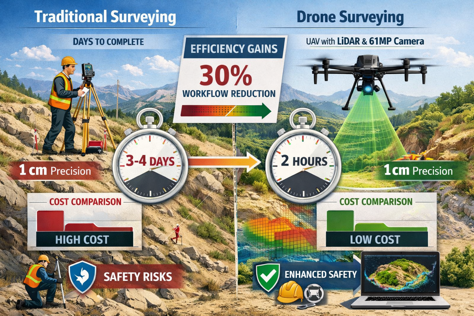
✅ Unprecedented Accuracy: Modern survey drones achieve absolute accuracy down to 1 centimeter, enabling high-precision cadastral mapping even in challenging environments[2]
✅ Dramatic Time Savings: Drones survey areas in hours that traditionally required days or weeks, with real-world projects reporting 30% reductions in pre-construction workflows[4]
✅ Cost-Effective Operations: Significantly lower operational costs through reduced personnel requirements and equipment needs while maintaining superior data quality[1]
✅ Enhanced Safety: Elimination of risks associated with surveyors navigating hazardous terrain, busy roads, and dangerous environments[1]
✅ Advanced Technology Integration: AI-driven analytics, LiDAR penetration through vegetation, and seamless integration with BIM and GIS platforms deliver comprehensive property intelligence[4]
Understanding the Technology Behind Drone Surveying
High-Resolution Camera Systems
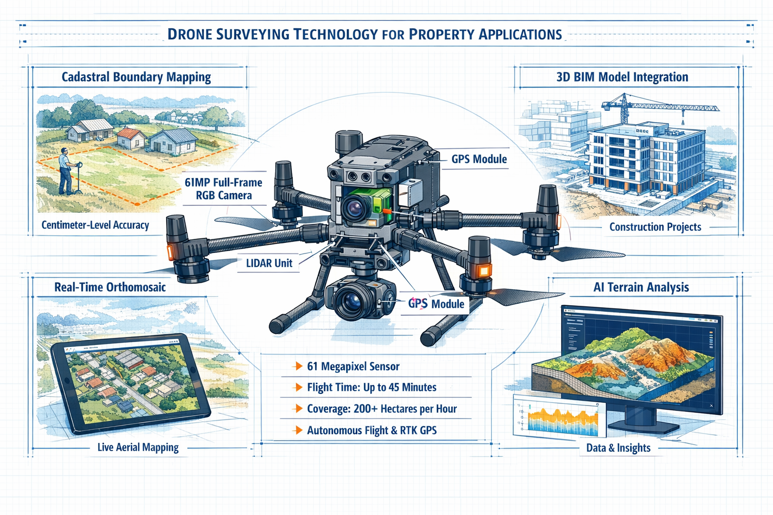
The foundation of effective drone surveying lies in cutting-edge imaging technology. Today's professional survey drones feature 61-megapixel full-frame RGB cameras capable of capturing extraordinarily detailed aerial imagery[2]. These cameras don't simply take photographs—they create the basis for precise photogrammetric analysis that generates accurate 3D models and measurements.
The resolution capabilities of modern drone cameras enable surveyors to identify features as small as individual property markers, fence posts, and utility access points from hundreds of feet in the air. This level of detail proves invaluable when conducting comprehensive property surveys that require documentation of existing conditions, boundaries, and infrastructure.
Key camera specifications that matter for property surveying:
- Sensor size: Full-frame sensors capture more light and detail
- Megapixel count: Higher resolution enables larger coverage areas while maintaining detail
- Lens quality: Professional-grade optics minimize distortion
- Shutter speed: Fast shutters prevent motion blur during flight
- Dynamic range: Captures detail in both shadows and highlights
LiDAR Technology: Seeing Through Vegetation
While high-resolution cameras excel at capturing surface details, LiDAR (Light Detection and Ranging) technology revolutionizes surveying by penetrating vegetation and revealing the true terrain beneath. LiDAR-equipped drones emit laser pulses that bounce off surfaces and return to the sensor, creating precise distance measurements[2].
This capability proves particularly valuable for:
🌳 Forested properties where ground features remain hidden under tree canopy
🏗️ Development sites requiring accurate bare-earth models
⛰️ Challenging terrain with dense vegetation or dust conditions
📊 Stockpile monitoring for mining and construction operations
LiDAR systems can penetrate vegetation and dust to reveal terrain beneath, making them indispensable for mining operations requiring real-time stockpile monitoring and accurate inventory management[2]. The technology generates point clouds containing millions of individual measurements, which software then processes into detailed topographic models.
Autonomous Flight and Real-Time Processing
Modern survey drones incorporate autonomous obstacle avoidance and autonomous return functions that enhance both safety and efficiency[2]. Operators can program flight paths that systematically cover large areas while the drone automatically adjusts altitude to maintain consistent ground sampling distance.
Perhaps most revolutionary is the capability for real-time data processing. Advanced drone solutions now generate 2D orthomosaics in real-time, allowing survey teams to immediately visualize land cover and identify changes without waiting for post-processing[3]. This immediate feedback enables:
- On-site decision making during active surveys
- Identification of data gaps requiring additional flight coverage
- Instant quality control verification
- Rapid preliminary reporting to stakeholders
The ability to operate multiple drones simultaneously using a single remote controller further accelerates coverage of extensive properties[2]. This multi-drone approach proves especially valuable for time-sensitive projects where rapid data collection determines project timelines.
Drone Applications in Property Surveying: Revolutionizing Accuracy and Efficiency in Practice
Topographic Mapping and Land Development
Topographic mapping represents one of the most common and valuable applications of drone surveying. Traditional ground-based topographic surveys require surveyors to physically walk the property, taking elevation measurements at intervals. This process becomes particularly challenging—and dangerous—on steep slopes, in dense vegetation, or across large areas.
Drones transform this process entirely. A single flight can capture thousands of elevation points per acre, creating detailed contour maps that reveal subtle terrain variations. The data accuracy rivals or exceeds traditional methods, with modern systems achieving 1-centimeter absolute accuracy[2].
Real-world impact: A highway expansion project in Phoenix demonstrated the practical benefits by reducing pre-construction workflows by 30% using drone mapping and 3D modeling[4]. The project team captured comprehensive topographic data across miles of corridor in a fraction of the time traditional methods would require, accelerating design work and reducing surveying costs.
For land development projects, drone-generated topographic data enables:
| Application | Benefit | Time Savings |
|---|---|---|
| Site grading plans | Accurate cut/fill calculations | 60-70% reduction |
| Drainage design | Precise watershed delineation | 50-60% reduction |
| Infrastructure planning | Optimal road and utility routing | 40-50% reduction |
| Environmental assessment | Comprehensive terrain analysis | 70-80% reduction |
When planning structural engineering work or development projects, accurate topographic data forms the foundation for all subsequent design decisions.
Cadastral and Boundary Surveying
Cadastral surveying—the precise measurement and documentation of property boundaries—demands exceptional accuracy. Property disputes, legal descriptions, and title transfers all depend on boundary surveys that meet rigorous standards.
Drones equipped with RTK (Real-Time Kinematic) GPS systems deliver the centimeter-level accuracy required for cadastral work[2]. By capturing high-resolution imagery that clearly shows existing boundary markers, fences, and monuments, drones create comprehensive visual records that supplement traditional ground measurements.
The workflow typically combines drone data with ground-based verification:
- Aerial survey captures comprehensive imagery and elevation data
- Ground control points provide precise reference coordinates
- Photogrammetric processing generates accurate orthomosaic maps
- Field verification confirms critical boundary markers
- Final documentation combines aerial and ground data
This hybrid approach delivers superior results compared to either method alone. The aerial perspective reveals boundary relationships and encroachments that ground surveyors might miss, while ground verification ensures legal defensibility.
Volumetric Analysis and Stockpile Measurement
Construction projects, mining operations, and land development all require accurate measurement of material volumes. Whether calculating earthwork quantities, monitoring stockpiles, or tracking excavation progress, volumetric analysis directly impacts project costs and scheduling.
Traditional volumetric surveying involves establishing grid points and manually measuring heights—a time-consuming process that provides only periodic snapshots. Drone surveying enables frequent, cost-effective volumetric measurements that support better inventory management and progress tracking[1].
The process works through these steps:
✈️ Drone captures detailed imagery of stockpiles or excavation areas
📐 Software generates 3D surface models from overlapping images
📊 Baseline surfaces establish reference elevations
🔢 Volume calculations compare current surface to baseline
📈 Reports track changes over time with high precision
Accuracy matters: Modern drone volumetric surveys achieve accuracy within 1-2% of actual volumes, meeting or exceeding industry standards for payment calculations and inventory management. This precision, combined with the speed of data collection, enables weekly or even daily volume tracking that was economically impractical with traditional methods.
Cost-Benefit Analysis: Why Drone Applications in Property Surveying Are Revolutionizing Efficiency
Direct Cost Reductions
The financial advantages of drone surveying become apparent when comparing operational costs. Traditional surveying requires:
- Multiple crew members (typically 2-3 people minimum)
- Extended field time (days or weeks for large sites)
- Equipment mobilization (vehicles, survey instruments, safety gear)
- Access arrangements (permissions, traffic control, safety measures)
Drone surveying dramatically reduces these requirements. The same work can be completed with fewer personnel and less equipment, directly reducing operational costs[1]. A single drone operator can often accomplish what previously required a full survey crew, and complete the work in a fraction of the time.
Cost comparison example (100-acre property survey):
| Method | Personnel | Time | Equipment Cost | Total Cost |
|---|---|---|---|---|
| Traditional | 3 surveyors | 5-7 days | $15,000 | $25,000-$30,000 |
| Drone-based | 1 operator + 1 assistant | 1-2 days | $8,000 | $10,000-$12,000 |
| Savings | 67% reduction | 80% reduction | 47% reduction | 60% reduction |
These savings multiply across multiple projects, making drone technology a sound investment for surveying firms. Many practices report that drone systems pay for themselves within the first year through increased efficiency and expanded service capabilities.
Understanding surveyor pricing structures helps property owners appreciate the value proposition that drone technology enables.
Time Efficiency and Project Acceleration
Beyond direct cost savings, time efficiency represents perhaps the most significant advantage of drone surveying. Projects that would require days or weeks using traditional ground-based methods can be surveyed in hours[1].
This acceleration delivers multiple benefits:
⏱️ Faster project initiation: Development projects begin sooner with rapid baseline surveys
📅 Compressed timelines: Design work starts immediately with complete site data
🔄 Frequent monitoring: Regular progress surveys track construction advancement
⚡ Quick decisions: Real-time data supports rapid response to site conditions
For time-sensitive projects, this speed advantage often outweighs even the direct cost savings. A development project delayed by weeks waiting for traditional survey data can incur costs far exceeding the survey itself through lost opportunity, extended financing costs, and delayed revenue generation.
The efficiency gains extend beyond initial surveys. When conducting specialist defect surveys or monitoring property conditions, drones enable frequent, cost-effective inspections that support proactive maintenance and issue identification.
Safety Improvements and Risk Reduction
The safety advantages of drone surveying cannot be overstated. Traditional surveying often requires personnel to work in challenging and potentially dangerous conditions:
⚠️ Steep slopes and unstable terrain
🚗 Active roadways and traffic zones
🏗️ Construction sites with heavy equipment
🌡️ Extreme weather conditions
🐍 Wildlife and environmental hazards
Drones eliminate risks associated with ground surveyors navigating challenging terrain, busy roads, and hazardous environments[1]. Operators maintain safe distances from hazards while capturing comprehensive data that would otherwise require physical presence in dangerous locations.
This risk reduction delivers tangible benefits:
- Reduced injury potential and associated workers' compensation costs
- Eliminated traffic control requirements for roadway surveys
- No confined space entry for certain inspection applications
- Minimized environmental disturbance in sensitive areas
Insurance companies increasingly recognize these safety benefits, with some offering premium reductions for surveying firms that implement comprehensive drone programs with proper safety protocols.
Advanced Applications and Emerging Technologies
Integration with BIM and GIS Platforms
The true power of drone surveying emerges when aerial data integrates seamlessly with Building Information Modeling (BIM) and Geographic Information Systems (GIS) platforms. Modern aerial survey companies harness AI-driven analytics, advanced LiDAR, and seamless integration with BIM and GIS platforms for enhanced data processing[4].
This integration enables:
🏗️ As-built documentation: Comparing actual construction to design models
📍 Asset management: Tracking infrastructure locations and conditions
🗺️ Master planning: Incorporating survey data into comprehensive development plans
🔍 Change detection: Identifying modifications over time through comparative analysis
When drone survey data flows directly into design software, engineers and architects work with current, accurate site conditions rather than outdated or incomplete information. This reduces design errors, minimizes change orders, and improves construction outcomes.
For commercial building surveys and large-scale development projects, BIM integration represents a fundamental shift in how survey data supports the entire project lifecycle.
AI-Driven Analytics and Automated Feature Extraction
Artificial intelligence is transforming how survey data gets processed and analyzed. Rather than manually identifying and measuring features in aerial imagery, AI-driven analytics automatically extract relevant information[4]:
- Automatic boundary detection from imagery patterns
- Vegetation classification distinguishing trees, grass, and bare earth
- Infrastructure identification locating utilities, roads, and structures
- Change detection highlighting modifications between survey dates
- Anomaly identification flagging unusual features requiring investigation
These AI capabilities dramatically reduce the time required to process survey data into actionable information. What once required hours of manual digitizing now happens automatically, with human oversight focused on verification and quality control rather than tedious data entry.
Machine learning algorithms continue improving as they process more data, meaning AI-assisted surveying becomes more accurate and capable over time. This technology democratizes advanced surveying capabilities, making sophisticated analysis accessible to smaller firms and individual practitioners.
Multi-Spectral and Thermal Imaging Applications
Beyond standard RGB cameras and LiDAR, specialized sensors expand drone surveying capabilities into new domains:
Multi-spectral imaging captures light across multiple wavelength bands, revealing information invisible to human eyes:
- Vegetation health analysis for agricultural and environmental assessment
- Moisture detection identifying drainage issues and water intrusion
- Material identification distinguishing surface types and conditions
Thermal imaging detects temperature variations that indicate:
- Heat loss from buildings and roofing systems
- Moisture problems showing as temperature anomalies
- Underground utilities revealed through thermal signatures
- Solar panel efficiency identifying underperforming arrays
These specialized applications extend drone surveying beyond traditional measurement into comprehensive property intelligence. When conducting building surveys, thermal data can identify issues that visual inspection alone would miss.
Best Practices for Implementing Drone Surveying
Equipment Selection and Investment
Choosing appropriate drone equipment requires balancing capabilities, costs, and intended applications. The market offers options ranging from consumer-grade quadcopters to professional mapping platforms costing tens of thousands of dollars.
Key considerations for equipment selection:
| Factor | Consumer Grade | Professional Grade | Survey-Specific |
|---|---|---|---|
| Camera resolution | 12-20MP | 20-48MP | 61MP+ |
| GPS accuracy | 5-10m | 1-5m | 1cm RTK |
| Flight time | 20-30 min | 30-45 min | 45-55 min |
| Obstacle avoidance | Basic | Advanced | Omnidirectional |
| Weather resistance | Limited | Moderate | High |
| Price range | $1,000-$3,000 | $5,000-$15,000 | $20,000-$50,000+ |
For professional surveying applications, investing in survey-specific platforms with RTK GPS and high-resolution cameras delivers the accuracy and reliability clients expect. While the initial investment appears substantial, the efficiency gains and expanded capabilities typically justify the cost.
Many surveying firms start with mid-range professional equipment and upgrade as their drone practice grows. This approach minimizes initial investment while building operational experience and client demand.
Regulatory Compliance and Certification
Operating drones for commercial surveying requires compliance with aviation regulations. In most jurisdictions, commercial drone operations require:
✅ Pilot certification (Remote Pilot Certificate or equivalent)
✅ Aircraft registration with aviation authorities
✅ Operating permissions for specific airspace and locations
✅ Insurance coverage for liability and equipment
✅ Privacy compliance respecting property rights and data protection
Regulations continue evolving as drone technology advances and adoption increases. Staying current with regulatory requirements protects both operators and clients from legal complications.
Professional organizations and industry associations provide valuable resources for understanding and maintaining compliance. Many offer training programs, certification courses, and ongoing education that support safe, legal drone operations.
Data Processing and Quality Control
Capturing aerial imagery represents only the first step in drone surveying. Data processing transforms raw images into usable survey products:
- Image upload and organization: Transferring and cataloging flight data
- Quality assessment: Reviewing coverage, overlap, and image quality
- Ground control integration: Incorporating reference coordinates
- Photogrammetric processing: Generating point clouds and 3D models
- Orthomosaic creation: Producing geometrically corrected imagery
- Feature extraction: Identifying and measuring relevant elements
- Quality control: Verifying accuracy against standards
- Deliverable preparation: Creating final maps, models, and reports
Robust quality control procedures ensure survey data meets accuracy requirements and professional standards. This includes:
- Check point verification comparing survey results to known coordinates
- Internal consistency checks ensuring measurements align throughout the dataset
- Peer review having experienced surveyors validate results
- Documentation maintaining records of methods, equipment, and conditions
Quality control becomes especially critical for surveys supporting property certification or legal purposes where accuracy and defensibility matter most.
Case Studies: Real-World Success Stories
Case Study 1: Residential Development Site Analysis
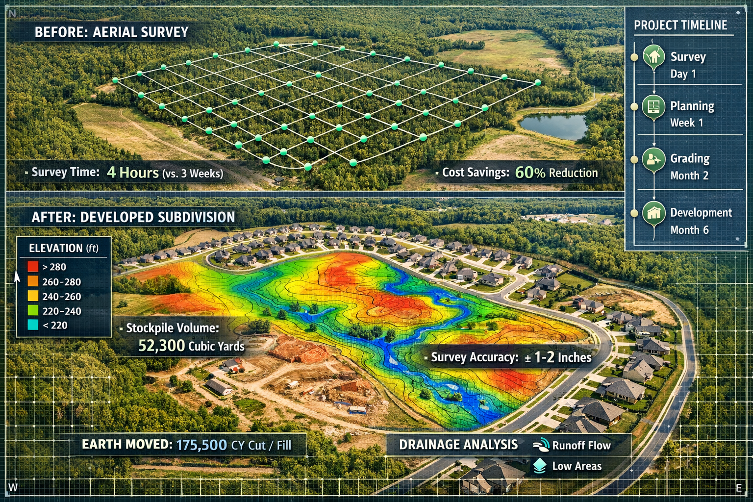
Project: 250-acre residential development in suburban area
Challenge: Steep terrain with dense vegetation, multiple drainage corridors, environmentally sensitive areas
Traditional approach: 3-4 weeks of ground surveying with 4-person crew
Drone solution implemented:
- Two days of aerial data collection using LiDAR-equipped drone
- High-resolution RGB imagery at 1cm ground sampling distance
- Multi-spectral imaging for vegetation analysis
- Real-time orthomosaic generation for immediate review
Results achieved:
- 85% time reduction (4 weeks reduced to 3 days total)
- 67% cost savings compared to traditional methods
- Superior data quality with complete terrain coverage under vegetation
- Enhanced safety eliminating need for surveyors on steep slopes
- Comprehensive deliverables including 3D models, contour maps, and vegetation analysis
The development team used the detailed topographic data to optimize road layouts, minimize grading costs, and identify optimal building sites. The drainage analysis informed stormwater management design, while vegetation mapping supported environmental permitting.
Case Study 2: Commercial Property Boundary Dispute Resolution
Project: Boundary dispute between two commercial properties
Challenge: Conflicting historical surveys, unclear boundary markers, disputed easement area
Traditional approach: Extensive research, ground surveying, potential litigation
Drone solution implemented:
- Comprehensive aerial survey with RTK GPS positioning
- High-resolution imagery documenting existing conditions
- Ground control survey tying to established monuments
- Photogrammetric processing generating accurate orthomosaic
- Integration with historical survey data and GIS records
Results achieved:
- Clear visual documentation showing relationship between properties
- Accurate measurements resolving discrepancies in historical surveys
- Neutral evidence supporting mediation and settlement
- Cost-effective resolution avoiding expensive litigation
- Comprehensive record for future reference
The detailed aerial imagery revealed encroachments and easement boundaries that ground surveys had difficulty documenting. The visual evidence, combined with accurate measurements, facilitated settlement negotiations and avoided costly legal proceedings.
Case Study 3: Mining Operation Stockpile Management
Project: Aggregate mining operation with multiple stockpiles
Challenge: Monthly inventory reporting, volume calculations for billing, operational planning
Traditional approach: Ground-based volume surveys requiring site shutdown and safety protocols
Drone solution implemented:
- Weekly drone surveys of all stockpile areas
- Automated flight planning for consistent data collection
- Cloud-based processing generating volume reports
- AI-assisted change detection identifying stockpile modifications
- Integration with inventory management systems
Results achieved:
- Weekly inventory updates replacing monthly surveys
- No operational disruption with surveys conducted during normal operations
- Improved accuracy (±1.5% volume measurement)
- Better planning with real-time inventory visibility
- Enhanced billing with accurate volume documentation
The mining operation gained unprecedented visibility into inventory levels, enabling better production planning and customer service. The frequent surveys revealed operational patterns and inefficiencies that monthly surveys had missed, supporting process improvements.
Future Trends in Drone Surveying Technology
Autonomous Survey Operations
The trajectory of drone technology points toward increasingly autonomous operations that require minimal human intervention. Future systems will:
🤖 Automatically plan optimal flight paths based on project requirements
🔄 Self-deploy from charging stations for scheduled surveys
📡 Communicate with air traffic systems for automated airspace coordination
🧠 Adapt to conditions adjusting parameters based on weather and lighting
📊 Process data onboard delivering results immediately upon landing
These autonomous capabilities will further reduce costs and increase accessibility, making professional-grade surveying available for routine monitoring and management applications.
Enhanced Sensor Integration
Next-generation survey drones will integrate multiple sensor types in single platforms:
- RGB + LiDAR + thermal + multi-spectral in unified systems
- Real-time sensor fusion combining data streams during flight
- Adaptive sensing automatically selecting optimal sensors for conditions
- Higher resolution with 100+ megapixel cameras becoming standard
This sensor integration will deliver comprehensive property intelligence from single flights, eliminating the need for multiple survey missions with different equipment.
Improved AI and Machine Learning
Artificial intelligence will continue transforming how survey data gets processed and utilized:
- Instant feature recognition identifying property elements automatically
- Predictive analytics forecasting maintenance needs and condition changes
- Automated reporting generating complete survey deliverables without manual intervention
- Quality assurance AI systems verifying data accuracy and completeness
These AI capabilities will dramatically reduce the time from data collection to actionable information, supporting faster decision-making and more responsive property management.
When considering how long surveys take, these technological advances promise continued reductions in turnaround times.
Regulatory Evolution
Aviation authorities worldwide are developing frameworks to safely accommodate expanded drone operations:
- Beyond visual line of sight (BVLOS) operations for large-area surveys
- Urban operations enabling surveys in populated areas
- Automated traffic management coordinating multiple drone operations
- Standardized certifications for survey-specific drone operations
These regulatory developments will unlock new applications and operational efficiencies, further accelerating adoption across the surveying industry.
Selecting Drone Surveying Services
Questions to Ask Providers
When engaging drone surveying services for property projects, consider these essential questions:
Technical capabilities:
- What equipment and sensors do you use?
- What accuracy can you achieve for my specific application?
- How do you ensure data quality and accuracy?
- What deliverables do you provide?
Experience and qualifications:
- What relevant projects have you completed?
- Are your pilots certified and insured?
- Do you have experience with my property type?
- Can you provide client references?
Process and timeline:
- How long will the survey take?
- What site access do you require?
- How quickly will I receive results?
- What happens if weather delays the survey?
Regulatory compliance:
- Do you have necessary operating permissions?
- How do you handle privacy and data protection?
- Are you insured for commercial operations?
- Do you comply with local aviation regulations?
Understanding what different survey types cost helps set appropriate budget expectations for drone surveying services.
Integration with Traditional Surveying
Drone surveying doesn't replace traditional surveying—it complements it. The most effective approach often combines aerial data collection with strategic ground-based verification:
Drones excel at:
- Large area coverage
- Topographic mapping
- Visual documentation
- Volumetric analysis
- Inaccessible area surveys
Traditional methods remain essential for:
- Legal boundary monuments
- Underground utilities
- Precise elevation benchmarks
- Property corners and markers
- Regulatory compliance requirements
Professional surveyors understand when each method provides optimal results and how to combine approaches for comprehensive property intelligence. This hybrid methodology delivers superior outcomes compared to either approach alone.
Overcoming Common Challenges
Weather and Environmental Limitations
While drone technology has advanced significantly, weather conditions still impact operations:
Wind: High winds affect stability and image quality
Rain: Moisture damages equipment and prevents safe flight
Fog: Reduces visibility and compromises imagery
Extreme temperatures: Affect battery performance and equipment operation
Professional drone surveyors monitor weather forecasts and plan operations during optimal conditions. For time-sensitive projects, having backup dates ensures survey completion despite weather challenges.
Data Management and Storage
High-resolution aerial surveys generate enormous data volumes. A single project might produce:
- Thousands of high-resolution images
- Point clouds with billions of measurements
- Multiple processed deliverables
- Historical data for comparison
Effective data management requires:
📁 Robust storage systems with adequate capacity and backup
🔐 Security measures protecting client confidential information
📋 Organization protocols enabling efficient data retrieval
⏰ Retention policies balancing storage costs with archival needs
Cloud-based solutions increasingly provide scalable, secure data management that grows with practice needs.
Client Education and Expectations
Many property owners and developers remain unfamiliar with drone surveying capabilities and limitations. Clear communication about what drone surveys can and cannot provide prevents misunderstandings:
✅ What clients should expect:
- Comprehensive aerial documentation
- Accurate measurements and models
- Faster turnaround than traditional methods
- Cost-effective large-area coverage
❌ What drones cannot replace:
- Legal boundary monuments
- Underground utility location
- Detailed structural inspection (interior)
- Certain regulatory requirements
Educating clients about drone surveying capabilities builds realistic expectations and ensures satisfaction with results.
Conclusion: Embracing the Surveying Revolution
Drone applications in property surveying: revolutionizing accuracy and efficiency represent far more than a technological novelty—they constitute a fundamental transformation in how professionals approach land measurement, analysis, and documentation. The combination of affordable UAV platforms, high-resolution sensors, LiDAR technology, and AI-driven processing has democratized capabilities that were previously accessible only to large firms with substantial equipment investments.
The evidence is compelling: 70% of construction projects now utilize drone surveys[4], the global market exceeds $6.5 billion[4], and real-world projects demonstrate 30% workflow reductions[4] and dramatic cost savings. These aren't future projections—they're current realities transforming the surveying profession in 2026.
For property owners, developers, and land managers, drone surveying delivers tangible benefits:
💰 Lower costs through reduced personnel and time requirements
⏱️ Faster results enabling quicker project initiation and decision-making
📊 Better data with comprehensive coverage and exceptional accuracy
🛡️ Enhanced safety eliminating hazardous field conditions
🔄 Frequent monitoring making regular surveys economically practical
The technology continues advancing rapidly, with autonomous operations, enhanced sensors, and AI-driven analytics promising even greater capabilities in coming years. Regulatory frameworks are evolving to accommodate expanded operations, while professional standards ensure quality and reliability.
Actionable Next Steps
For property owners and developers:
- Explore drone surveying options for your next project by contacting qualified surveying professionals
- Request demonstrations to understand capabilities and deliverables
- Compare costs and timelines against traditional surveying approaches
- Consider ongoing monitoring for properties requiring regular assessment
- Ask about integration with your existing design and management systems
For surveying professionals:
- Evaluate equipment options matching your practice needs and budget
- Obtain necessary certifications and regulatory approvals
- Develop processing workflows ensuring quality and efficiency
- Build client awareness through education and demonstration projects
- Stay current with technological advances and industry best practices
For project managers and consultants:
- Specify drone surveying where appropriate in project scopes
- Understand capabilities to set realistic expectations
- Plan schedules accounting for weather dependencies
- Ensure data compatibility with project software and systems
- Verify qualifications of drone surveying providers
The revolution in property surveying isn't coming—it's here. Organizations and professionals who embrace drone technology gain competitive advantages through superior efficiency, reduced costs, and enhanced capabilities. Those who delay adoption risk falling behind as clients increasingly expect the speed, accuracy, and value that drone surveying delivers.
The question isn't whether to adopt drone surveying—it's how quickly to implement this transformative technology. With proven results, accessible equipment, and expanding applications, the case for drone applications in property surveying has never been stronger. The future of surveying is aerial, autonomous, and remarkably accurate—and that future is now.
References
[1] Drone Surveying – https://uavcoach.com/drone-surveying/
[2] Drone For Mapping – https://www.jouav.com/blog/drone-for-mapping.html
[3] Land Surveying – https://enterprise.dji.com/surveying/land-surveying
[4] Aerial Survey Companies – https://www.extremeaerialproductions.com/post/aerial-survey-companies
[5] Watch – https://www.youtube.com/watch?v=K4EVh9gH_qM
[6] Webinar The State Of Drone Surveying A Strategic Briefing For 2026 – https://www.aerotas.com/blog/webinar-the-state-of-drone-surveying-a-strategic-briefing-for-2026
[7] Foundations Of Drone Surveying – https://www.propelleraero.com/blog/foundations-of-drone-surveying/
[8] Watch – https://www.youtube.com/watch?v=CSTodaZb4Vc