The landscape of land title surveying is shifting beneath surveyors' feet. On February 23, 2026, new standards take effect that will fundamentally change how professionals approach boundary surveys, documentation requirements, and client communications. For surveyors who have relied on title insurers to provide adjoining property deeds, the game has changed—and understanding these updates isn't optional.
The 2026 ALTA/NSPS Land Title Survey Updates: What Surveyors Must Know represent more than routine revisions. These standards, adopted by the American Land Title Association (ALTA) and the National Society of Professional Surveyors (NSPS) in October 2025, eliminate long-standing requirements while clarifying others that have caused confusion for years[3]. After more than three years of collaborative development, these changes aim to reduce risk, improve precision, and align professional practices with real-world conditions[3].
Whether you're a seasoned surveyor or new to ALTA/NSPS work, these updates will affect every land title survey you certify from this point forward. The question isn't whether to adapt—it's how quickly you can implement these changes while maintaining the accuracy and thoroughness your clients expect.
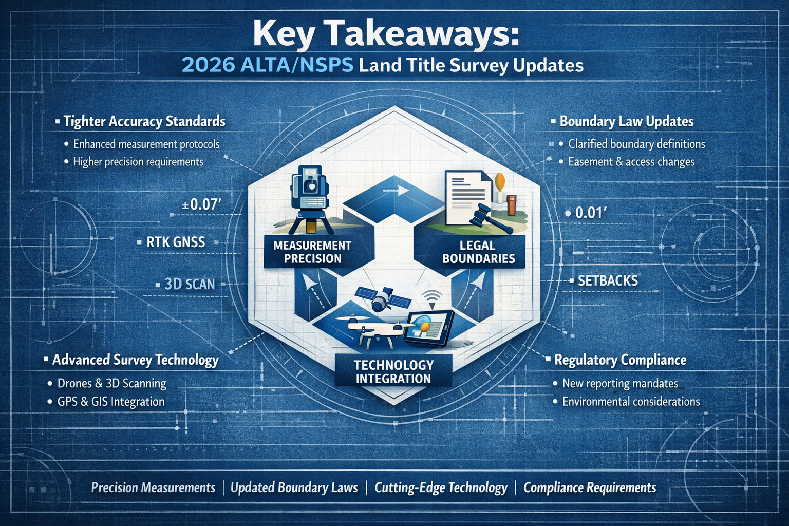
Key Takeaways
✅ Effective Date: The 2026 Minimum Standard Detail Requirements officially take effect on February 23, 2026, replacing the 2021 standards for all new survey contracts[1][3]
✅ Adjoining Deed Requirement Eliminated: Title insurers are no longer required to provide copies of adjoining property deeds, placing full research responsibility on surveyors[3]
✅ Clarified RPP Definition: Relative Positional Precision now has a clearer, more accessible definition while maintaining alignment with accepted measurement practices[2]
✅ Standardized Evidence Language: "Visible evidence" requirements have been replaced with uniform "evidence observed in the process of conducting fieldwork" language throughout[3]
✅ No True "Updates" Exist: Any surveyor certification of current conditions constitutes a new survey that must comply with current standards—there are no technical "updates"[3]
Understanding the 2026 ALTA/NSPS Land Title Survey Updates: What Surveyors Must Know
The Evolution of Professional Surveying Standards
Land title surveys serve as the foundation for real estate transactions worth billions of dollars annually. These specialized surveys provide lenders, buyers, title insurers, and investors with critical information about property boundaries, improvements, easements, and potential encroachments. The ALTA/NSPS standards have long represented the benchmark for these high-stakes surveys.
The 2026 ALTA/NSPS Land Title Survey Updates: What Surveyors Must Know emerged from extensive collaboration between surveying professionals, title insurance companies, and real estate stakeholders. Over three years of development went into refining these standards to address practical challenges surveyors face in the field[3].
Previous versions of the standards contained ambiguities that led to inconsistent interpretations. Some requirements didn't align with actual industry practices, creating unnecessary burdens. The 2026 updates tackle these issues head-on, streamlining processes while maintaining—and in some cases enhancing—the rigor that makes ALTA/NSPS surveys the gold standard.
Why These Updates Matter for Your Practice
Every surveyor conducting land title work must understand that these aren't minor technical adjustments. The changes affect:
- Research obligations and what materials you must independently obtain
- Documentation standards for evidence of occupation and possession
- Precision requirements and how you communicate measurement accuracy
- Client communications about what the survey includes and excludes
- Liability exposure based on new clarifications of professional responsibilities
Professional surveyors who work with local chartered surveyors understand that staying current with evolving standards protects both their practice and their clients. The 2026 updates are no exception.
Major Changes in the 2026 ALTA/NSPS Land Title Survey Updates: What Surveyors Must Know
1. Elimination of Title Insurer Deed Requirement 📋
Perhaps the most significant practical change involves adjoining property deeds. Under previous standards, title insurers were required to provide copies of deeds for properties adjoining the surveyed parcel. The 2026 standards eliminate this requirement entirely[3].
Why the change? The reality is that most title companies don't typically provide these deeds as a standard practice. More importantly, surveyors in virtually every state with survey standards are already obligated to obtain these documents independently as part of their professional due diligence[3].
What this means for surveyors:
- You must independently research and obtain adjoining property deeds without relying on title companies
- Your research process must be documented and thorough
- Budget additional time and resources for deed research in your project planning
- Establish reliable access to county records, online databases, and research tools
This change actually reduces risk for all parties by ensuring surveyors conduct complete, independent research rather than relying on potentially incomplete information from title insurers[7]. It places responsibility where it logically belongs—with the professional trained to interpret and apply boundary evidence.
2. Clarified Relative Positional Precision (RPP) Definition 🎯
Relative Positional Precision measures how accurately surveyors locate property boundaries and features relative to each other. The 2026 standards provide a revised and clearer definition of RPP that makes this statistical measurement more accessible to those unfamiliar with advanced surveying concepts[2].
The updated definition:
- Maintains alignment with accepted measurement practices
- Provides clearer explanation for clients, lenders, and title professionals
- Emphasizes transparency in communicating measurement uncertainty
- Helps non-surveyors understand the precision of boundary determinations
Why precision matters: In high-value commercial real estate transactions, even small measurement discrepancies can have significant financial implications. Clear RPP standards ensure all parties understand the confidence level associated with boundary locations.
For surveyors, this means:
- More straightforward communication with clients about measurement accuracy
- Reduced confusion when explaining technical precision concepts
- Better alignment between field practices and documentation requirements
- Enhanced professional credibility through transparent precision reporting
3. Standardized "Evidence Observed" Language 🔍
Section 5.B.iii of previous standards created confusion by requiring "visible evidence" while other sections used the phrase "evidence observed in the process of conducting fieldwork." This inconsistency led to questions about whether different standards applied to different survey elements[3].
The 2026 updates standardize this language throughout the document, applying the "evidence observed in the process of conducting fieldwork" burden uniformly across all sections[3].
Key clarification: The standards now explicitly specify that vehicular access must be included in this evidence[3].
This standardization:
- Eliminates ambiguity about observation requirements
- Creates consistent expectations across all survey elements
- Clarifies that surveyors must document what they observe during fieldwork
- Reduces potential disputes about whether evidence was "visible" versus "observed"
Similar to how building surveys require consistent documentation standards, land title surveys benefit from uniform language that leaves no room for interpretation.
4. Boundary Proximity Clarification 📏
A source of significant confusion in previous standards involved how far from the property boundary surveyors needed to document evidence of possession or occupation. Some interpreted the standards as limiting this requirement to features within 5 feet of the perimeter.
The 2026 standards add the phrase "regardless of proximity to perimeter boundary lines" to Section 5.C.i, making it crystal clear that evidence of possession or occupation must be shown no matter how far from the boundary it appears[3].
Practical implications:
- Document fences, structures, and occupation evidence throughout the property
- Don't limit observations to a 5-foot perimeter zone
- Include interior features that indicate possession or use patterns
- Photograph and note evidence even if it's well inside property boundaries
This clarification ensures comprehensive documentation that could prove critical in boundary disputes or title claims. Just as specific defect reports require thorough documentation of building issues, land title surveys must now clearly document all possession evidence.
5. Table A Item 15 Imagery Modification 📸
Table A of the ALTA/NSPS standards lists optional survey elements that clients may request. Item 15 relates to showing certain features through imagery rather than traditional ground surveying methods.
The 2026 standards revise Item 15 to revert to its original intent, allowing imagery (aerial photographs, satellite imagery, etc.) as the basis for showing certain features[3]. However, this comes with important limitations:
- Written agreements required between client, lender, and title insurer
- Clear documentation of what features are shown via imagery versus ground survey
- Specific limitations on what can be depicted through imagery alone
- Transparency about the precision and currency of imagery sources
This modification recognizes that modern technology provides valuable tools for certain survey elements while maintaining professional standards for critical boundary determinations. The key is proper disclosure and agreement among all parties.
6. Refined Definitions and Documentation Requirements 📝
Beyond specific technical changes, the 2026 standards emphasize:
- Clearer documentation of survey methods and sources
- Greater transparency in communicating limitations and assumptions
- Improved communication between surveyors and clients
- Enhanced precision requirements for boundary determinations[2]
These refinements reflect a broader trend toward professionalism and accountability in surveying practice. Clients increasingly expect detailed explanations of survey methodology, not just final plat drawings.
Much like RICS building surveys that provide comprehensive documentation of property conditions, modern land title surveys must offer complete transparency about research, fieldwork, and analytical processes.
7. Title Commitment Requirement Reinforced 📄
The 2026 standards reinforce that surveyors must be provided a copy of the most recent title commitment or other title evidence satisfactory to the insurer to complete their work properly[3].
This isn't new, but the emphasis reflects ongoing challenges where surveyors begin work without complete title information. The standards make clear that:
- Title commitments are essential source documents, not optional
- Surveyors cannot properly evaluate title exceptions without them
- Clients must provide this information at project inception
- Delays in obtaining title commitments delay survey completion
Best practice: Make title commitment receipt a contractual prerequisite before beginning fieldwork. This protects your timeline and ensures you have the information needed to deliver a compliant survey.
Implementation Timeline and Contract Considerations
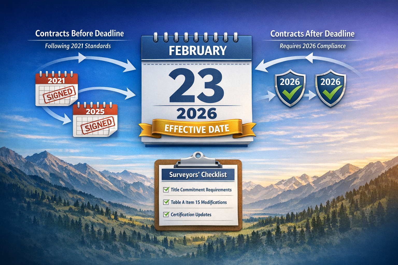
The February 23, 2026 Effective Date 📅
Understanding when the new standards apply is crucial for managing your survey pipeline. The rules are straightforward:
If a contract to perform an ALTA/NSPS Land Title Survey is executed on or after February 23, 2026, the survey must comply with the 2026 standards[3].
If a contract was executed before February 23, 2026 but the survey will be completed after that date, surveyors may conduct work under 2021 standards under limited circumstances[3]. However, this creates potential complications:
- Clients may expect 2026 compliance even if contracted under 2021 standards
- Lenders and title insurers may require 2026 standards regardless of contract date
- Mixing standards between contract and completion dates creates confusion
Recommendation: For any survey that will be certified after February 23, 2026, consider applying 2026 standards regardless of contract execution date. This eliminates ambiguity and ensures your work meets current professional expectations.
There Are No "Updates" Under the Standards ⚠️
A critical concept that many clients misunderstand: there is no such thing as a technical "update" under ALTA/NSPS standards[3].
Any surveyor certification of current conditions constitutes a new survey performed under current standards requirements. You cannot simply "update" a 2021 survey to 2026 standards—you must conduct a new survey that complies with all 2026 requirements.
This distinction matters for:
- Pricing and scope discussions with clients who request "updates"
- Liability considerations when certifying current conditions
- Professional standards compliance and potential disciplinary issues
- Client expectations about timeline and deliverables
When a client asks for an "updated" survey, explain that you'll be conducting a new survey under current standards. This sets proper expectations and ensures your work meets professional requirements.
Transitioning Your Practice to 2026 Standards
Action steps for surveyors:
- Review the complete 2026 standards document thoroughly—don't rely solely on summaries
- Update your standard contracts and engagement letters to reference 2026 standards
- Revise your fieldwork checklists to reflect new evidence documentation requirements
- Establish reliable deed research processes that don't depend on title company provision
- Train your field crews on standardized evidence observation and documentation
- Update client communication materials explaining the changes and their implications
- Review professional liability insurance to ensure coverage aligns with new standards
Similar to how professionals offering structural surveys must stay current with building codes and engineering standards, land surveyors must proactively adapt to evolving ALTA/NSPS requirements.
Implications for Surveyors, Lenders, and Title Professionals

Enhanced Surveyor Responsibilities 🎓
The 2026 updates place greater emphasis on independent professional judgment and thorough research. Surveyors can no longer rely on title companies to provide adjoining deeds or assume that "visible evidence" has a different standard than "evidence observed."
Professional development priorities:
- Strengthen deed research skills and access to records
- Enhance understanding of statistical precision concepts for client communication
- Develop systematic fieldwork documentation processes
- Improve written communication about survey limitations and assumptions
These enhanced responsibilities also create opportunities for differentiation. Surveyors who excel at thorough research, clear communication, and precise work will stand out in a competitive market.
Client Communication and Expectation Management 💬
The 2026 standards require proactive communication with clients about:
- Timeline implications of independent deed research requirements
- Cost factors associated with comprehensive evidence documentation
- Precision levels and what RPP means for boundary confidence
- Table A selections and which optional items add value for their specific transaction
Best practices for client discussions:
- Schedule a pre-survey conference to review requirements and expectations
- Provide written explanations of standard versus optional survey elements
- Clarify that "updates" are actually new surveys under current standards
- Establish clear deliverable timelines that account for research and fieldwork requirements
Just as choosing the right property survey requires understanding different survey types and their purposes, clients need education about what ALTA/NSPS surveys include and why certain requirements exist.
Lender and Title Company Considerations 🏦
Lenders and title insurance companies must also adapt to the 2026 standards:
- Review internal survey requirements to ensure alignment with 2026 standards[2]
- Communicate with surveyors early about required detail levels and Table A items[2]
- Provide title commitments promptly to avoid delaying survey work
- Understand that adjoining deed provision is no longer required from title companies[3]
Coordination is key: Early communication between lenders, title companies, and surveyors about project-specific requirements prevents delays and ensures everyone understands their responsibilities under the new standards.
Risk Reduction Through Enhanced Standards 🛡️
The ultimate goal of the 2026 updates is risk reduction for all parties involved in real estate transactions[7]. By ensuring surveyors conduct thorough, independent research and document evidence comprehensively, the standards protect:
- Buyers from unexpected boundary disputes or encroachments
- Sellers from title defects that could derail transactions
- Lenders from collateral issues that affect loan security
- Title insurers from claims based on survey deficiencies
- Surveyors from liability arising from incomplete or ambiguous work
Enhanced standards create short-term adaptation challenges but long-term benefits for professional practice and client service.
Practical Compliance Strategies for the 2026 ALTA/NSPS Land Title Survey Updates: What Surveyors Must Know
Developing Robust Research Protocols 📚
With title insurers no longer required to provide adjoining deeds, surveyors must establish systematic research protocols:
Essential research components:
- County recorder/registrar office access (online and in-person)
- Subscription to property records databases
- Relationships with title abstractors for complex research
- Organized filing systems for research documentation
- Quality control procedures to verify deed chain accuracy
Research workflow example:
- Obtain subject property deed and legal description
- Identify all adjoining properties from plat maps and field observation
- Research deeds for each adjoining property
- Document deed references, recording information, and legal descriptions
- Analyze boundary descriptions for conflicts or gaps
- Note any discrepancies for further investigation
- Maintain organized research file with all source documents
This systematic approach ensures nothing falls through the cracks and provides documentation of your thorough professional process.
Standardizing Field Documentation 📋
Uniform "evidence observed in the process of conducting fieldwork" language requires consistent field documentation practices:
Field documentation checklist:
✓ Photograph all boundary monuments and markers
✓ Document fences, walls, and other occupation evidence (regardless of proximity to boundaries)
✓ Note vehicular access points and conditions
✓ Record utility locations and visible infrastructure
✓ Photograph structures and improvements
✓ Document any evidence of encroachments or boundary disputes
✓ Note weather and site conditions affecting observations
✓ Record equipment used and measurement methods
Technology tools:
- Field data collection software with photo integration
- GPS-enabled cameras for geotagged images
- Cloud-based data storage for team access
- Standardized field note templates
- Mobile apps for sketch creation and annotation
Consistent field documentation not only ensures standards compliance but also provides valuable evidence if questions arise later about survey findings.
Communicating Precision and Limitations 📊
The clarified RPP definition requires improved communication about measurement precision:
Client communication strategies:
- Explain RPP in plain language: "This tells you how confident we are about boundary locations"
- Provide context: "Our measurements are accurate to within ±0.07 feet at the 95% confidence level"
- Relate precision to practical implications: "This level of precision is appropriate for commercial transactions"
- Document precision methodology in survey notes and certifications
- Be transparent about factors affecting precision (monument quality, vegetation, etc.)
Sample client explanation:
"Relative Positional Precision measures how accurately we've located property corners and boundaries relative to each other. Think of it as a confidence level for our measurements. For this survey, our RPP of 0.07 feet means we're 95% confident that features are located within 0.07 feet of their true positions relative to each other."
Clear precision communication builds client confidence and demonstrates professional expertise.
Managing Table A Selections 📝
With modifications to Table A Item 15 and other optional elements, surveyors should:
Proactively guide clients through Table A selections based on property type and transaction needs
Document agreements when imagery will be used instead of ground survey for specific features
Clarify cost implications of each optional item
Explain limitations of imagery-based depictions versus ground-surveyed features
Obtain written authorization from client, lender, and title insurer for Item 15 imagery use[3]
Table A decision framework:
| Item | Typical Use Case | Cost Impact | Client Benefit |
|---|---|---|---|
| Item 1 (Monuments) | All surveys | Moderate | Essential for boundary verification |
| Item 2 (Addresses) | Multi-parcel properties | Low | Clarifies property identification |
| Item 6 (Height/Floor Area) | Zoning compliance | Moderate | Verifies building code compliance |
| Item 15 (Imagery) | Large properties | Variable | Cost-effective feature depiction |
Thoughtful Table A guidance demonstrates value-added service and helps clients make informed decisions.
Common Questions About the 2026 ALTA/NSPS Land Title Survey Updates: What Surveyors Must Know
What happens to surveys in progress on February 23, 2026?
Surveys contracted before the effective date may be completed under 2021 standards in limited circumstances[3]. However, best practice suggests applying 2026 standards to any survey certified after the effective date to avoid confusion and ensure current compliance.
Do I need to obtain adjoining deeds even if the title company provides them?
Yes. Under 2026 standards, surveyors have independent professional responsibility to research and obtain adjoining property deeds[3]. You cannot rely solely on title company-provided documents—you must conduct your own thorough research.
How does the RPP clarification affect my fieldwork?
The RPP definition clarification primarily affects how you communicate precision to clients rather than changing fieldwork methodology. However, it emphasizes the importance of documenting your measurement processes and precision calculations clearly.
Can I still call it an "update" when a client requests a new survey?
No. The standards are clear that there is no such thing as an "update"[3]. Any certification of current conditions is a new survey that must comply with current standards. Educate clients about this distinction to set proper expectations.
What if my client doesn't want to pay for comprehensive evidence documentation?
The standards define minimum requirements that aren't negotiable. If a client wants an ALTA/NSPS Land Title Survey, it must comply with the standards. You can explain that comprehensive documentation protects their interests and reduces risk for all parties involved.
How do the 2026 standards affect my professional liability?
By clarifying requirements and eliminating ambiguities, the 2026 standards should ultimately reduce liability exposure for surveyors who comply fully. Clear standards make it easier to demonstrate that you met professional obligations. However, failure to comply with updated standards could increase liability.
Do these standards apply to surveys outside the United States?
ALTA/NSPS standards are U.S.-specific, though they're sometimes referenced internationally. Surveyors working outside the U.S. should consult local professional standards and requirements. For surveyors working across different regions, understanding local requirements is essential—similar to how chartered surveyors in London must comply with UK-specific regulations.
Professional Development and Continuing Education
Staying Current with Evolving Standards 📖
The 2026 updates won't be the last changes to ALTA/NSPS standards. Surveyors committed to professional excellence should:
Join professional organizations like NSPS and state surveying societies that provide standards updates
Attend continuing education programs focused on ALTA/NSPS survey requirements
Participate in webinars and workshops addressing the 2026 changes
Read professional publications that analyze standards implications
Network with peers to discuss implementation challenges and solutions
Review case studies of surveys conducted under new standards
Resources for Understanding the Updates
Official sources:
- ALTA website (www.alta.org) for complete standards documents[1]
- NSPS resources (nsps.us.com) for surveyor-specific guidance[5]
- State surveying board publications for jurisdiction-specific requirements
Professional development:
- ALTA/NSPS standards webinars and training sessions
- State surveying society conferences and workshops
- Online courses focused on land title survey requirements
- Peer review programs for quality assurance
Technical resources:
- Survey software vendor updates for 2026 standards compliance
- Template libraries for survey notes and certifications
- Precision calculation tools and RPP documentation aids
Continuous learning ensures your practice remains at the forefront of professional standards and client service.
The Broader Context: Why Standards Matter
Protecting Real Estate Transaction Integrity 🏢
Land title surveys serve as critical due diligence tools in real estate transactions. The 2026 ALTA/NSPS Land Title Survey Updates: What Surveyors Must Know reflect the surveying profession's commitment to protecting transaction integrity through:
Accurate boundary determination that prevents future disputes
Comprehensive documentation of property conditions and potential issues
Clear communication of findings to all transaction parties
Professional standards that ensure consistent, reliable survey work
When surveyors deliver high-quality ALTA/NSPS surveys, they protect buyers from purchasing properties with hidden boundary problems, protect lenders from making loans secured by defective collateral, and protect title insurers from claims arising from survey deficiencies.
The Evolution of Professional Surveying 📐
The 2026 standards represent the latest evolution in a long history of professional surveying standards development. Each update reflects:
- Lessons learned from previous standards implementation
- Technological advances in measurement and documentation
- Changing real estate market needs and expectations
- Collaboration between surveyors and industry stakeholders
Just as homebuyer surveys have evolved to provide more comprehensive property information, ALTA/NSPS standards continue advancing to meet modern real estate transaction needs.
Building Client Trust Through Professional Excellence 🤝
Ultimately, standards exist to ensure professional excellence that builds client trust. When clients know that ALTA/NSPS surveys follow rigorous, well-defined standards, they can rely on survey findings with confidence.
Surveyors who embrace the 2026 updates as opportunities to demonstrate professional competence—rather than viewing them as burdensome requirements—will strengthen client relationships and enhance their professional reputation.
Conclusion: Embracing the 2026 ALTA/NSPS Land Title Survey Updates
The 2026 ALTA/NSPS Land Title Survey Updates: What Surveyors Must Know represent significant changes that will affect every land title survey conducted from February 23, 2026 forward. From eliminating the title insurer deed requirement to clarifying evidence documentation standards, these updates streamline some processes while enhancing rigor in others.
The most critical changes include:
🔹 Independent deed research responsibility now rests entirely with surveyors
🔹 Standardized evidence language eliminates previous ambiguities
🔹 Clarified RPP definition improves precision communication
🔹 Boundary proximity clarification requires comprehensive documentation regardless of distance
🔹 No technical "updates" exist—all current certifications are new surveys under current standards
For surveyors, these changes demand proactive adaptation. Those who invest in robust research protocols, systematic field documentation, clear client communication, and ongoing professional development will thrive under the new standards.
Actionable Next Steps for Surveyors 🎯
Immediate actions (before February 23, 2026):
- ✅ Download and thoroughly review the complete 2026 ALTA/NSPS standards document
- ✅ Update all contract templates and engagement letters to reference 2026 standards
- ✅ Revise fieldwork checklists and documentation procedures
- ✅ Establish reliable deed research processes and database access
- ✅ Train field crews on new evidence documentation requirements
Short-term actions (first quarter 2026):
- ✅ Conduct internal quality review of first surveys under 2026 standards
- ✅ Gather client feedback on communication and documentation clarity
- ✅ Refine research and fieldwork processes based on initial implementation experience
- ✅ Attend professional development programs focused on 2026 standards
- ✅ Update marketing materials to highlight 2026 standards compliance
Ongoing actions:
- ✅ Monitor professional publications for implementation guidance and case studies
- ✅ Participate in peer discussions about standards interpretation
- ✅ Maintain current knowledge of any clarifications or amendments
- ✅ Continuously improve client communication about standards and requirements
- ✅ Document lessons learned to inform future standards development
The Path Forward
Change creates opportunity. Surveyors who view the 2026 standards as a chance to demonstrate professional excellence—rather than as an inconvenient burden—will strengthen their practices and enhance client service.
The elimination of the title insurer deed requirement, while requiring additional surveyor effort, ensures thorough independent research that reduces risk for all parties. The standardized evidence language removes ambiguity that previously led to inconsistent interpretations. The clarified RPP definition improves communication with non-surveyor stakeholders.
These are positive developments that advance the surveying profession and protect real estate transaction integrity.
Success under the 2026 standards requires:
- Commitment to thorough, independent professional research
- Systematic field documentation processes
- Clear, transparent client communication
- Ongoing professional development and standards knowledge
- Quality-focused practice management
The 2026 ALTA/NSPS Land Title Survey Updates: What Surveyors Must Know aren't just technical requirements—they're the foundation for professional excellence in land title surveying. Embrace them, implement them thoroughly, and use them as opportunities to demonstrate the value that professional surveyors bring to every real estate transaction.
The effective date is approaching. The time to prepare is now. Your clients, your profession, and your practice will benefit from your proactive adaptation to these important standards updates.
For surveyors seeking additional guidance on survey standards and best practices, professional resources like expert witness surveyors can provide valuable insights into documentation and professional standards compliance.
References
[1] 20260126 Alta Insights Understanding The 2026 Altansps Land Title Survey Standards – https://www.alta.org/news-and-publications/news/20260126-ALTA-Insights-Understanding-the-2026-ALTANSPS-Land-Title-Survey-Standards
[2] New 2026 Minimum Standard Detail 3684174 – https://www.jdsupra.com/legalnews/new-2026-minimum-standard-detail-3684174/
[3] The 2026 Minimum Standard Detail Requirements For Alta Nsps Land Title Surveys – https://amerisurv.com/2026/02/01/the-2026-minimum-standard-detail-requirements-for-alta-nsps-land-title-surveys/
[4] 2026 Alta Nsps Land Title Survey Standards – https://www.partneresi.com/resources/references/standards-regulations/2026-alta-nsps-land-title-survey-standards/
[5] 2021alta – https://nsps.us.com/page/2021ALTA
[6] New 2026 Altansps Minimum Standard Detail Requirements – https://www.osls.org/news/716390/NEW-2026-ALTANSPS-Minimum-Standard-Detail-Requirements.htm
[7] What The 2026 Altansps Updates Mean For Cre Professionals – https://www.globest.com/2025/12/22/what-the-2026-altansps-updates-mean-for-cre-professionals/