Urban landscapes are transforming rapidly, and nowhere is this more evident than in the rise of mixed-use developments that combine retail, residential, and commercial spaces within single projects. As cities densify and demand for walkable neighborhoods intensifies, surveyors face unprecedented challenges in navigating the complex intersection of zoning regulations, utility infrastructure, and market demands. Surveying Mixed-Use Developments: Integrating Retail-Residential Zoning Challenges in 2026 Urban Projects requires a sophisticated understanding of both technical surveying principles and evolving regulatory frameworks that govern these hybrid spaces.
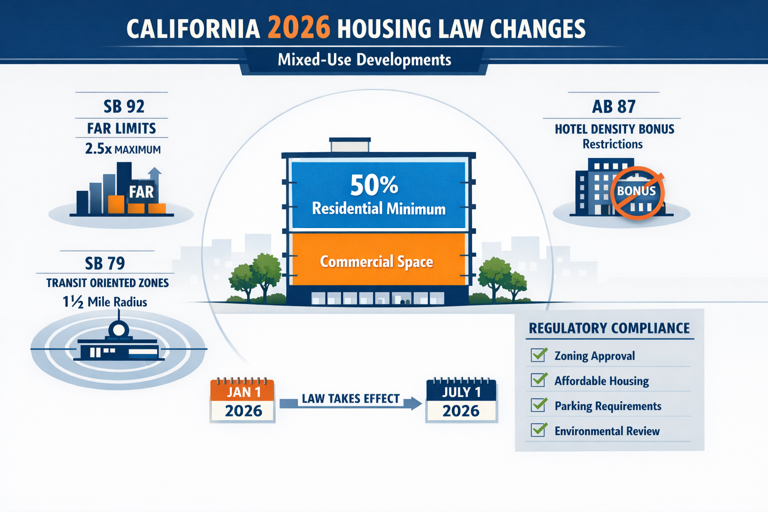
The year 2026 brings significant legislative changes that fundamentally reshape how mixed-use projects are planned, surveyed, and executed. New California housing laws impose stricter commercial floor area limits, redefine residential dedication requirements, and introduce transit-oriented development (TOD) provisions that override local ordinances[1][3]. These regulatory shifts demand that surveyors adapt their methodologies to accommodate multiple zoning overlays, complex utility conflicts, and the precise boundary determinations that separate retail from residential uses within the same structure.
Professional surveying firms must now integrate comprehensive commercial property survey expertise with residential assessment capabilities to serve the mixed-use market effectively. This article explores the critical surveying techniques, regulatory considerations, and practical solutions that define successful mixed-use development projects in 2026's evolving urban environment.
Key Takeaways
✅ New 2026 regulations impose a 2.5x commercial floor area ratio limit and require 50% residential dedication for adaptive reuse projects, fundamentally changing surveying requirements for mixed-use developments[1][3]
✅ Transit-oriented development (TOD) provisions effective July 1, 2026, override local zoning ordinances near major transit stations, creating new surveying challenges for boundary determination and density calculations[4][5]
✅ Utility conflict resolution represents one of the most complex surveying challenges in mixed-use projects, requiring coordination between retail, residential, and commercial infrastructure systems
✅ Zoning overlay mapping demands precision surveying to delineate commercial versus residential boundaries within single structures, with legal implications for compliance and future development rights
✅ Market demand analysis from leading consulting firms indicates strong growth in hybrid spaces that combine living, working, and shopping functions, driving increased need for specialized surveying services
Understanding the Regulatory Landscape for Surveying Mixed-Use Developments in 2026
The regulatory environment governing mixed-use developments has undergone substantial transformation in 2026, creating new parameters that surveyors must navigate with precision. SB 92, effective January 1, 2026, imposes state density bonus law limits that prevent commercial floor area ratios from exceeding 2.5 times the base zoning ratio for commercial portions of mixed-use projects[1][3]. This legislation directly impacts how surveyors calculate buildable area and determine compliance with density requirements.
Commercial Floor Area Ratio Restrictions
The 2.5x commercial floor area ratio (FAR) limitation represents a significant constraint on mixed-use development design. Surveyors must accurately measure:
- Base zoning FAR for the underlying commercial district
- Proposed commercial square footage across all floors
- Total lot area to establish the maximum allowable commercial space
- Vertical separation between commercial and residential uses
For example, a mixed-use project on a 10,000 square foot lot in a C-2 commercial zone with a base FAR of 1.0 would be limited to 25,000 square feet of commercial space (10,000 × 1.0 × 2.5), even if density bonus provisions might otherwise allow greater commercial intensity[3].
Residential Dedication Requirements
The 50% residential dedication mandate for adaptive reuse projects, implemented July 1, 2026, requires that at least half of total square footage be designated for residential uses[1][3]. This creates specific surveying challenges:
📊 Square footage verification across multiple floors and building sections
📊 Common area allocation between residential and commercial uses
📊 Measurement standard consistency (gross versus net square footage)
📊 Conversion documentation for adaptive reuse projects changing from single-use to mixed-use
Professional surveyors conducting RICS commercial building surveys must now incorporate residential measurement standards within the same assessment, requiring dual expertise in both commercial and residential surveying protocols.
Hotel and Transient Lodging Restrictions
AB 87, also effective January 1, 2026, eliminates state density bonus law benefits for hotel portions of mixed-use projects[3]. This legislation closes a loophole where developers could gain incentives without expanding the residential housing stock. The Housing Accountability Act definition revision now requires at least two-thirds of new or converted square footage be designated for residential use, with prohibition on hotel or transient lodging uses except in specified circumstances[3].
Surveyors must clearly delineate:
- Permanent residential units versus transient accommodations
- Common facilities that serve both residential and hotel uses
- Separate entrances and circulation systems
- Utility metering boundaries between residential and commercial spaces
Transit-Oriented Development Surveying: New Challenges Under SB 79
SB 79, effective July 1, 2026, introduces transformative provisions for transit-oriented development that override local ordinances and deem TOD projects meeting certain criteria as allowable uses near major transit stations[4][5]. This legislation enables multifamily or mixed-use housing on parcels zoned for residential, mixed-use, commercial, or light industrial uses within defined TOD zones.
Defining TOD Zone Boundaries
Metropolitan planning organizations must map qualifying transit stops and TOD zones to identify eligible properties[5]. Surveyors play a critical role in:
🚇 Measuring precise distances from property boundaries to major transit stations
🚇 Verifying half-mile radius eligibility for TOD provisions
🚇 Documenting existing zoning classifications that qualify for TOD overrides
🚇 Establishing property line relationships to transit infrastructure
The half-mile radius measurement must account for actual walking distances along public rights-of-way, not simple radial measurements, creating complex surveying scenarios in irregular street grids.
Transit Agency Zoning Authority
A particularly significant provision allows transit agencies to develop zoning standards for agency-owned property within TOD zones, governing height, density, floor area ratio, and approved retail and commercial uses[4]. Transit agency requirements take precedence over inconsistent local objective development criteria, creating a dual regulatory framework.
Surveyors must coordinate with:
- Local planning departments for base zoning requirements
- Transit agencies for overlay zoning standards
- State housing authorities for density bonus calculations
- Utility providers for infrastructure capacity assessments
This multi-jurisdictional coordination demands comprehensive documentation and clear communication of which regulatory framework governs specific aspects of the development.
Campus Development Zone Fast-Tracking
New provisions effective January 1, 2026 (repealing January 1, 2033) allow expedited review for mixed-income housing developments on commercially zoned properties within a half-mile radius of UC, CSU, and California Community College campuses[3]. These campus development zones create additional surveying considerations:
| Surveying Requirement | Campus Zone Specification | Standard TOD Specification |
|---|---|---|
| Distance measurement | Half-mile from campus boundary | Half-mile from transit station |
| Eligible base zoning | Commercial only | Residential, mixed-use, commercial, light industrial |
| Affordability verification | Cal Grant, Promise Grant, Pell Grant eligibility | Standard income limits |
| Review timeline | Expedited process | Standard ministerial review |
Professional surveyors must verify campus boundary measurements with precision, as eligibility for expedited review depends on accurate distance calculations.
Technical Surveying Methodologies for Surveying Mixed-Use Developments: Integrating Retail-Residential Zoning Challenges in 2026 Urban Projects
The physical complexity of mixed-use developments demands advanced surveying techniques that go beyond traditional single-use property assessments. Modern surveyors employ a combination of conventional and cutting-edge technologies to address the unique challenges these projects present.
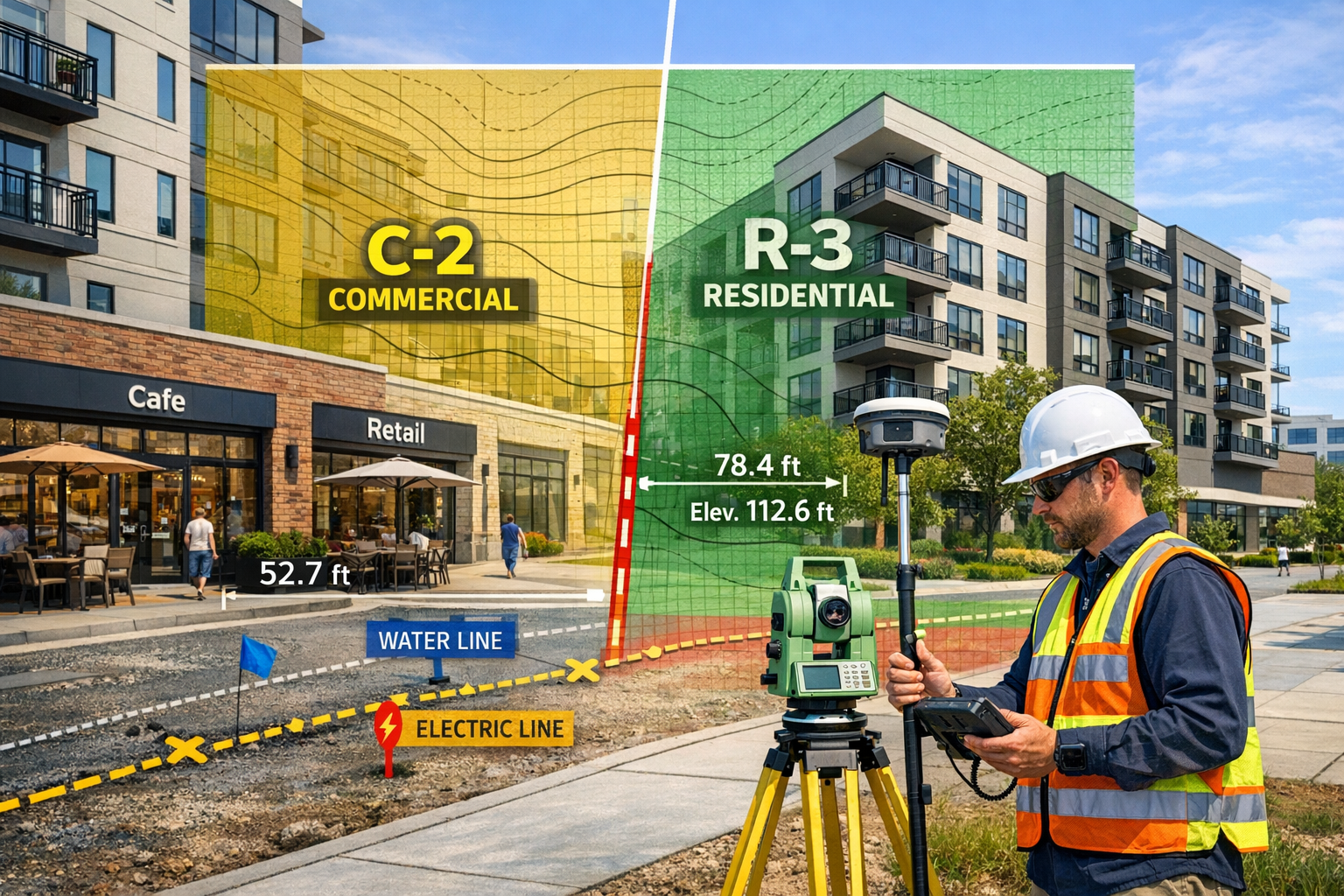
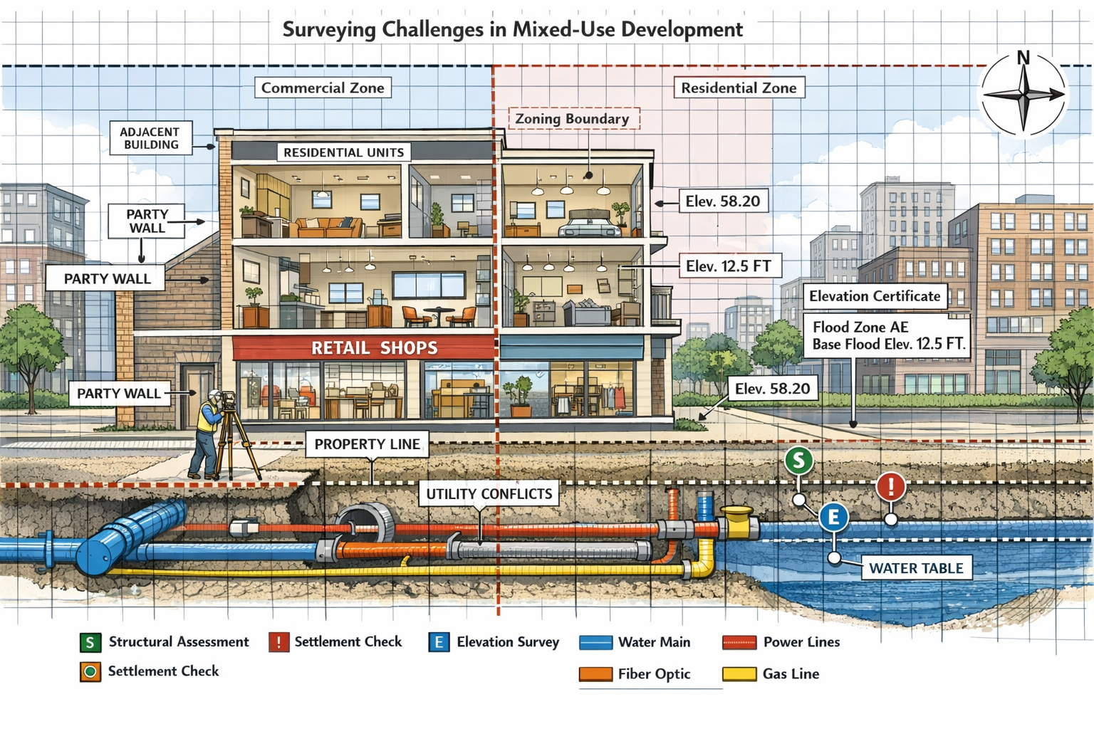
Boundary Survey Precision in Multi-Use Contexts
Boundary determination forms the foundation of all mixed-use development surveying. Unlike single-use properties, mixed-use projects often involve:
- Vertical property divisions between commercial and residential condominiums
- Airspace parcels that separate ground-floor retail from upper residential units
- Easements and access rights serving different use categories
- Party wall agreements between adjacent mixed-use properties
Professional structural surveys must document these complex ownership and use boundaries with legal precision. Modern surveying practice employs GPS technology with sub-centimeter accuracy, total station measurements for vertical control, and 3D laser scanning to capture the complete spatial relationships within mixed-use structures.
Zoning Overlay Mapping Techniques
Mixed-use developments frequently exist within multiple zoning overlays that impose different requirements on various portions of the property. Effective surveying must clearly delineate:
✏️ Base zoning district boundaries across the property
✏️ Overlay zone limits (historic districts, design review zones, TOD areas)
✏️ Special use districts that modify standard requirements
✏️ Transition zones where different regulations meet
Advanced Geographic Information System (GIS) integration allows surveyors to overlay multiple regulatory frameworks onto precise property boundaries, creating comprehensive zoning compliance maps that guide development design. These digital mapping products must be coordinated with commercial property valuation assessments to ensure regulatory compliance supports project feasibility.
Utility Conflict Identification and Resolution
Utility conflicts represent one of the most challenging aspects of surveying mixed-use developments. The combination of retail, residential, and potentially office uses creates complex infrastructure demands:
Water and Sewer Systems:
- Separate metering for commercial and residential uses
- Higher capacity requirements for retail food service
- Fire suppression systems serving multiple occupancy types
- Backflow prevention between commercial and residential systems
Electrical and Gas Infrastructure:
- Commercial-grade service for retail tenants
- Residential metering for individual units
- Emergency power systems serving common areas
- Renewable energy integration and net metering boundaries
Telecommunications and Data:
- Fiber optic backbone for commercial tenants
- Individual residential service connections
- Shared infrastructure in common areas
- Smart building systems serving multiple use types
Professional surveyors employ subsurface utility engineering (SUE) methodologies to identify existing utilities and plan new infrastructure routing. This process involves:
- Quality Level D (QL-D): Desktop review of existing utility records
- Quality Level C (QL-C): Surface geophysical methods to detect utilities
- Quality Level B (QL-B): Test holes to expose and verify utility locations
- Quality Level A (QL-A): Precise measurement and mapping of exposed utilities
The integration of specialist defect surveys helps identify potential conflicts early in the development process, reducing costly redesigns during construction.
Vertical Measurement and Floor Area Calculations
Accurate floor area calculations are critical for compliance with the new 2.5x commercial FAR limits and 50% residential dedication requirements[1][3]. Surveyors must employ consistent measurement standards:
- BOMA (Building Owners and Managers Association) standards for commercial space
- ANSI (American National Standards Institute) standards for residential units
- Common area allocation methodologies that fairly distribute shared spaces
- Vertical penetration deductions for stairs, elevators, and mechanical shafts
The challenge intensifies when commercial and residential uses occupy different portions of the same floor level, requiring precise horizontal and vertical boundary determination within the building envelope.
Building Envelope Protection and Adaptive Reuse Surveying
The 2026 regulatory framework introduces important provisions regarding building envelope protection for adaptive reuse projects. Local governments are prohibited from imposing development standards that require alteration of the existing building envelope, subject to limited exceptions[3].
Existing Condition Documentation
Surveyors conducting adaptive reuse assessments must thoroughly document:
🏗️ Existing building envelope dimensions (height, width, depth, setbacks)
🏗️ Structural capacity for proposed use changes
🏗️ Historical architectural features that may limit modifications
🏗️ Code compliance gaps between existing conditions and current requirements
This documentation protects developers from local requirements that would force envelope alterations, while establishing the baseline for permissible modifications. Professional Level 3 building surveys provide the comprehensive assessment needed for complex adaptive reuse projects.
Structural Assessment for Mixed-Use Conversion
Converting single-use commercial or industrial buildings to mixed-use requires careful structural evaluation:
- Floor load capacity for residential occupancy versus commercial/industrial
- Fire separation requirements between different use types
- Acoustic isolation between retail and residential spaces
- Egress and life safety systems serving multiple occupancies
Surveyors must coordinate with structural engineers to verify that existing buildings can accommodate the loading, separation, and safety requirements of mixed-use occupancy without major envelope alterations. Structural engineering services provide the technical analysis that complements surveying documentation.
Historic District Considerations
AB 1061, effective January 1, 2026, expands eligibility for certain housing projects within historic districts by deleting absolute exemptions, though parcels individually listed as historic resources or landmarks remain excluded[3]. This creates nuanced surveying requirements:
| Property Classification | Survey Requirements | Development Flexibility |
|---|---|---|
| Within historic district (not individually listed) | Standard boundary and condition survey | Expanded eligibility under AB 1061 |
| Individually listed historic resource | Comprehensive historic documentation | Remains excluded from streamlined provisions |
| Contributing structure in historic district | Detailed architectural feature documentation | Case-by-case review required |
| Non-contributing structure in historic district | Standard survey with district context | Generally eligible for streamlined review |
Surveyors must research property status thoroughly and document historic features that may influence development approvals, even when streamlined provisions apply.
Market Demand Analysis and Surveying Implications
Leading consulting firms, including PwC (PricewaterhouseCoopers), have identified strong market demand for hybrid spaces that combine living, working, and shopping functions within walkable urban environments. This market trend drives specific surveying requirements that support project feasibility and financing.
Highest and Best Use Analysis
Surveyors contribute to highest and best use determinations by providing accurate data on:
- Developable area under current zoning and overlay regulations
- Infrastructure capacity to support various use mixes
- Access and circulation patterns that enhance retail visibility and residential privacy
- Comparable development density and use ratios in the market area
This analysis informs developers about optimal retail-residential ratios that maximize project value while maintaining regulatory compliance. Professional property valuation services integrate surveying data with market analysis to support investment decisions.
Retail Visibility and Residential Privacy Balance
Successful mixed-use developments must balance retail visibility requirements with residential privacy needs. Surveying contributes to this balance by:
📍 Documenting sightlines from major streets to ground-floor retail
📍 Measuring setbacks that provide residential buffer zones
📍 Analyzing pedestrian circulation patterns that separate retail traffic from residential entries
📍 Evaluating parking access that serves both uses without conflicts
These spatial relationships significantly impact project marketability and must be carefully documented during the surveying phase.
Shared Amenity Space Allocation
Modern mixed-use developments often include shared amenity spaces such as:
- Rooftop gardens and terraces
- Fitness centers and community rooms
- Coworking spaces and business centers
- Parking structures serving multiple uses
Surveyors must accurately measure and allocate these spaces, determining:
- Total amenity square footage for regulatory compliance
- Pro rata allocation between residential and commercial uses
- Common area maintenance (CAM) boundaries and responsibilities
- Access easements ensuring all users can reach shared facilities
Clear surveying documentation prevents future disputes about amenity access and maintenance obligations.
Coastal Zone and Environmental Surveying Considerations
California's coastal zone presents additional surveying challenges for mixed-use developments. New 2026 provisions require that Accessory Dwelling Unit (ADU) Coastal Development Permits (CDPs) be approved or denied within 60 days, running concurrently with ministerial land use review[1].
Coastal Boundary Determination
Mixed-use projects in coastal zones require precise determination of:
🌊 Mean high tide line establishing coastal zone boundaries
🌊 Setback measurements from coastal resources
🌊 Public access easements through or adjacent to the property
🌊 Wetland and habitat boundaries that limit development areas
These measurements must meet California Coastal Commission standards and integrate with local zoning requirements, creating a complex regulatory overlay that demands specialized surveying expertise.
Environmental Constraint Mapping
Beyond coastal considerations, mixed-use developments may face various environmental constraints:
- Flood zone designations requiring elevation certificates
- Seismic hazard zones demanding geotechnical investigation
- Contaminated sites needing environmental remediation
- Wetland and riparian buffers limiting buildable area
Professional surveyors coordinate with environmental consultants to map these constraints accurately, ensuring development plans comply with all applicable regulations. Soil and water contamination assessments may be necessary for adaptive reuse projects converting industrial sites to mixed-use.
Coordination with Multiple Stakeholders in Mixed-Use Projects
Surveying Mixed-Use Developments: Integrating Retail-Residential Zoning Challenges in 2026 Urban Projects requires extensive coordination among diverse stakeholders, each with specific information needs and regulatory responsibilities.
Municipal Planning and Building Departments
Local planning departments require surveying documentation that demonstrates:
- Compliance with base zoning requirements (setbacks, height, coverage)
- Conformance with overlay district standards
- Satisfaction of parking and loading requirements
- Adherence to design review guidelines
Building departments need detailed surveys showing:
- Property boundaries for permit application
- Existing conditions for renovation projects
- Utility connection points and capacities
- Fire department access and emergency vehicle circulation
Surveyors must format deliverables to meet specific municipal requirements, which vary significantly across jurisdictions.
Transit Agencies and Transportation Planners
Under the new TOD provisions, transit agencies have expanded authority over development standards[4]. Surveyors must coordinate with:
- Transit agency planning staff to verify TOD zone eligibility
- Transportation planners regarding pedestrian access to transit stations
- Traffic engineers analyzing circulation impacts
- Parking management authorities for shared parking arrangements
This coordination ensures that surveying documentation supports both regulatory compliance and functional integration with transit infrastructure.
Utility Providers and Infrastructure Agencies
Utility coordination represents a critical surveying function, requiring engagement with:
- Water and sewer districts for capacity verification
- Electric and gas utilities for service planning
- Telecommunications providers for fiber and wireless infrastructure
- Stormwater management agencies for drainage design
Surveyors facilitate this coordination by providing accurate base mapping that utility engineers use for infrastructure design.
Financial Institutions and Investors
Lenders and investors rely on surveying documentation to assess project risks and value. Key deliverables include:
💰 ALTA/NSPS Land Title Surveys meeting lender requirements
💰 Boundary and topographic surveys supporting construction cost estimates
💰 As-built surveys documenting completed improvements for permanent financing
💰 Easement and encumbrance documentation affecting property rights and marketability
Professional surveyors understand that their work directly impacts project financing and must meet the rigorous standards financial institutions require.
Technology Integration in Modern Mixed-Use Development Surveying
The complexity of Surveying Mixed-Use Developments: Integrating Retail-Residential Zoning Challenges in 2026 Urban Projects drives adoption of advanced technologies that improve accuracy, efficiency, and documentation quality.
3D Laser Scanning and Building Information Modeling
3D laser scanning technology captures millions of data points to create precise digital representations of existing buildings and sites. For mixed-use developments, this technology offers:
- Complete spatial documentation of existing structures for adaptive reuse
- Accurate as-built conditions for renovation planning
- Clash detection identifying conflicts between proposed improvements and existing conditions
- Virtual site access allowing remote review by stakeholders
Integration with Building Information Modeling (BIM) creates intelligent 3D models that link spatial data with property information, regulatory requirements, and construction specifications. This integration supports coordination among architects, engineers, and contractors throughout the development process.
Drone Surveying for Site Analysis
Unmanned aerial vehicles (UAVs) or drones provide efficient site documentation for mixed-use projects, particularly on larger development parcels. Drone surveys offer:
✈️ Aerial photography documenting site context and surrounding development
✈️ Topographic mapping through photogrammetry processing
✈️ Progress monitoring during construction phases
✈️ Marketing imagery supporting project promotion
Regulatory compliance requires proper FAA authorization and coordination with local airspace restrictions, particularly in urban environments.
GIS Integration for Regulatory Compliance
Geographic Information Systems (GIS) technology enables sophisticated analysis of zoning overlays, environmental constraints, and infrastructure capacity. Modern surveying practice integrates field measurements with GIS databases to:
- Overlay multiple zoning districts and regulatory frameworks
- Analyze spatial relationships to transit stations, schools, and amenities
- Model development scenarios under different regulatory provisions
- Generate compliance documentation for permit applications
This integration ensures that surveying deliverables directly support regulatory approval processes.
Mobile Data Collection and Cloud Collaboration
Mobile surveying applications allow field crews to collect data digitally, eliminating transcription errors and accelerating deliverable production. Cloud-based collaboration platforms enable:
- Real-time data sharing among project team members
- Version control for survey documents and drawings
- Secure access to sensitive property information
- Integration with project management systems
These technologies improve efficiency and reduce the timeline from field work to final deliverables.
Best Practices for Surveyors Working on Mixed-Use Developments
Professional surveyors can enhance their effectiveness on mixed-use projects by adopting proven best practices that address the unique challenges these developments present.
Early Engagement in the Development Process
Early surveyor involvement provides maximum value by:
🎯 Identifying regulatory constraints before design investment
🎯 Documenting existing conditions that influence development feasibility
🎯 Coordinating with utility providers during preliminary planning
🎯 Establishing accurate base mapping for architectural design
Developers who engage surveyors early avoid costly redesigns when regulatory or physical constraints emerge late in the process.
Comprehensive Regulatory Research
Effective surveying requires thorough understanding of:
- Base zoning regulations and overlay districts
- State housing law provisions affecting the project
- Local design guidelines and development standards
- Utility connection requirements and capacity limitations
Surveyors should maintain current knowledge of regulatory changes, including the significant 2026 housing law updates[1][3][4], and communicate implications to clients clearly.
Interdisciplinary Coordination
Mixed-use projects demand coordination with:
- Architects translating regulatory requirements into design solutions
- Civil engineers designing site improvements and utilities
- Structural engineers assessing building capacity for use changes
- Environmental consultants addressing contamination and habitat issues
- Traffic engineers analyzing circulation and parking impacts
Professional surveyors facilitate this coordination by providing accurate base information and participating in integrated project teams.
Quality Control and Documentation Standards
Rigorous quality control ensures surveying deliverables meet professional standards:
| Quality Control Element | Implementation Method | Verification Process |
|---|---|---|
| Measurement accuracy | Redundant observations, equipment calibration | Independent check measurements |
| Boundary determination | Research of title documents, monument recovery | Legal description reconciliation |
| Regulatory compliance | Zoning code review, permit requirement checklist | Municipal plan check coordination |
| Deliverable formatting | CAD standards, title block requirements | Internal review before submittal |
Professional liability insurance and errors and omissions coverage protect both surveyors and clients from unintended errors.
Client Communication and Education
Clear communication helps clients understand:
- Regulatory constraints affecting development potential
- Surveying limitations and assumptions
- Timeline requirements for various deliverables
- Cost implications of scope changes
Surveyors who educate clients about the surveying process build trust and prevent misunderstandings about deliverable content and limitations.
Future Trends in Mixed-Use Development Surveying
The evolution of urban development and regulatory frameworks suggests several trends that will shape surveying practice beyond 2026.
Increased Density and Vertical Mixed-Use
Market demand for urban housing and commercial space will drive higher-density mixed-use projects with more complex vertical integration of uses. Surveyors will need:
- Enhanced vertical measurement capabilities
- Sophisticated 3D modeling skills
- Understanding of complex condominium and airspace parcel creation
- Coordination with structural engineers on high-rise projects
Climate Resilience and Sustainability Requirements
Growing emphasis on climate adaptation will add new surveying requirements:
🌱 Sea level rise and flood resilience mapping
🌱 Green infrastructure and stormwater management documentation
🌱 Solar access analysis for renewable energy systems
🌱 Urban heat island mitigation through site design
Surveyors will increasingly integrate environmental performance metrics into standard deliverables.
Automated and AI-Enhanced Surveying
Artificial intelligence and machine learning will transform surveying practice through:
- Automated feature extraction from laser scan data
- AI-assisted zoning code interpretation
- Predictive modeling of regulatory approval likelihood
- Robotic total stations and autonomous surveying vehicles
These technologies will improve efficiency while requiring new skills in data science and software integration.
Expanded Transit-Oriented Development
As TOD provisions mature and transit infrastructure expands, more properties will fall within TOD zones[4][5]. Surveyors will develop specialized expertise in:
- Transit proximity verification and documentation
- Pedestrian access and walkability analysis
- Integration with transit agency zoning standards
- Mixed-use density optimization near transit stations
This specialization will become increasingly valuable as TOD becomes the dominant urban development paradigm.
Conclusion: Mastering the Complexity of Mixed-Use Development Surveying
Surveying Mixed-Use Developments: Integrating Retail-Residential Zoning Challenges in 2026 Urban Projects represents one of the most complex and rewarding specializations in modern surveying practice. The convergence of new regulatory frameworks, market demand for hybrid urban spaces, and technological capabilities creates both challenges and opportunities for professional surveyors.
The 2026 legislative changes—including commercial floor area ratio limits, residential dedication requirements, and transit-oriented development provisions—fundamentally reshape the regulatory landscape[1][3][4]. Surveyors who master these new requirements position themselves as essential partners in successful urban development projects.
Technical excellence in boundary determination, utility conflict resolution, and zoning overlay mapping provides the foundation for effective mixed-use surveying. Integration of advanced technologies including 3D laser scanning, drone surveying, and GIS analysis enhances both accuracy and efficiency. Coordination with multiple stakeholders—from municipal planners to transit agencies to financial institutions—ensures that surveying deliverables meet diverse information needs.
Actionable Next Steps for Surveying Professionals
✔️ Update technical knowledge regarding 2026 California housing law changes and their implications for mixed-use projects
✔️ Invest in technology including 3D scanning, drone capabilities, and GIS integration to enhance service offerings
✔️ Develop relationships with transit agencies, utility providers, and municipal planners who influence mixed-use development approvals
✔️ Pursue continuing education in areas such as TOD zoning, adaptive reuse requirements, and environmental constraint mapping
✔️ Create standardized workflows for common mixed-use surveying deliverables to improve efficiency and consistency
✔️ Build interdisciplinary teams with structural engineers, environmental consultants, and planning specialists to provide comprehensive services
For property developers and owners considering mixed-use projects, engaging qualified surveyors early in the development process provides critical benefits. Professional structural surveys and commercial building assessments establish the foundation for successful project planning and regulatory approval.
The future of urban development lies in walkable, transit-oriented, mixed-use neighborhoods that integrate living, working, and shopping within cohesive communities. Professional surveyors who master the technical, regulatory, and coordination challenges of these complex projects will find growing demand for their expertise throughout 2026 and beyond. By combining traditional surveying precision with modern technology and comprehensive regulatory knowledge, surveying professionals can deliver the accurate, timely documentation that transforms mixed-use development visions into built reality.
References
[1] Californias 2026 Housing Laws What You Need To Know – https://www.hklaw.com/en/insights/publications/2025/12/californias-2026-housing-laws-what-you-need-to-know
[2] 2025 26 Legislative Session Key Developments In Housing Land Use And Transportation Policy Area – https://www.counties.org/news-and-media-article/2025-26-legislative-session-key-developments-in-housing-land-use-and-transportation-policy-area/
[3] B Legguide – https://landuse.saccounty.gov/szc/b_legguide/
[4] 2026 California Housing Law Updates Key Changes And Impacts – https://www.publicceo.com/2026/02/2026-california-housing-law-updates-key-changes-and-impacts/
[5] New California Laws Expand Redevelopment Opportunities For Commercial Property Owners And Developers – https://harvestllp.com/articles/new-california-laws-expand-redevelopment-opportunities-for-commercial-property-owners-and-developers/