The property surveying profession stands at a transformative crossroads in 2026. What was once the exclusive domain of large engineering firms with six-figure equipment budgets has become accessible to small and medium-sized surveying practices. Reality capture goes mainstream: accessible tools for property surveyors in 2026 marks a fundamental shift in how professionals document, analyze, and report on building conditions. This democratization of technology is reshaping the competitive landscape and redefining client expectations across the industry.
For decades, property surveyors relied on measuring tapes, laser distance meters, and visual inspection to assess buildings. Today, affordable LiDAR scanners, consumer-grade drones, and AI-powered processing software enable even solo practitioners to deliver millimeter-accurate 3D models, comprehensive digital twins, and data-rich reports that were unimaginable just five years ago. This technological revolution arrives at a critical moment, as the industry faces persistent workforce shortages and increasing demands for faster, more detailed property assessments.
Key Takeaways
-
🚀 Reality capture technology has become financially accessible to small surveying firms, with entry-level systems starting under £5,000 and delivering professional-grade results that rival equipment costing ten times more just three years ago.
-
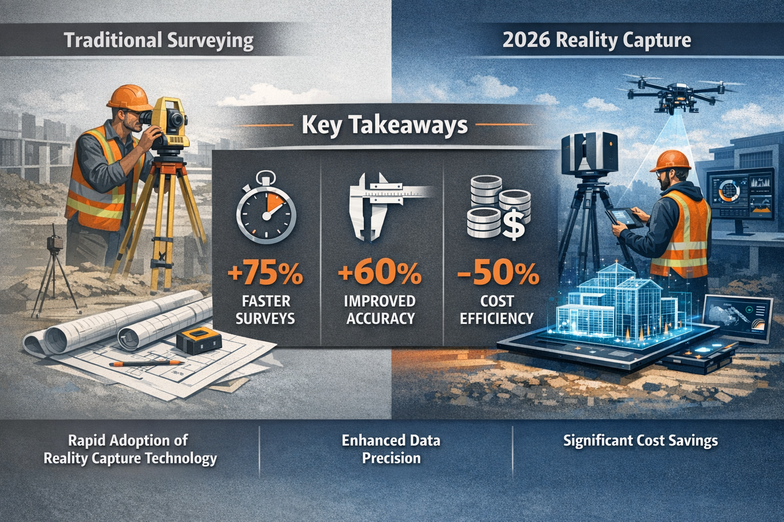
📊 Mobile mapping systems and handheld LiDAR scanners enable surveyors to complete comprehensive property documentation in hours rather than days, reducing project timelines by 60-70% while improving accuracy and safety.
-
🤖 AI-powered processing workflows automate time-consuming tasks like point cloud classification, defect detection, and measurement extraction, allowing surveyors to focus on analysis and client consultation rather than manual data processing.
-
👥 Workforce shortages are accelerating adoption as firms leverage reality capture technology to accomplish more with smaller teams, with a single surveyor equipped with modern tools matching the output of traditional three-person crews.
-
🔄 Integration across the property lifecycle means reality capture data now serves multiple stakeholders—from initial property surveys through construction monitoring to facility management—creating new revenue opportunities for forward-thinking surveying practices.
Understanding Reality Capture Technology for Property Surveyors
Reality capture refers to the process of digitally documenting physical spaces and objects using various technologies to create accurate 3D representations. For property surveyors, this means transforming buildings, land parcels, and infrastructure into detailed digital models that can be measured, analyzed, and shared with unprecedented precision.
What Makes Reality Capture Different from Traditional Surveying?
Traditional surveying methods require surveyors to manually measure and record specific points and features. A comprehensive structural survey might involve hundreds of individual measurements, photographs, and notes compiled over several site visits. Reality capture inverts this approach by collecting millions of data points automatically, creating a complete digital record that can be interrogated indefinitely.
The fundamental advantages include:
- Comprehensive documentation: Capture everything, not just predetermined measurement points
- Remote analysis capability: Review site conditions from the office without return visits
- Objective evidence: Digital records eliminate disputes about pre-existing conditions
- Client accessibility: Share interactive 3D models that clients can explore themselves
- Future-proof data: Digital twins remain valuable throughout a property's lifecycle
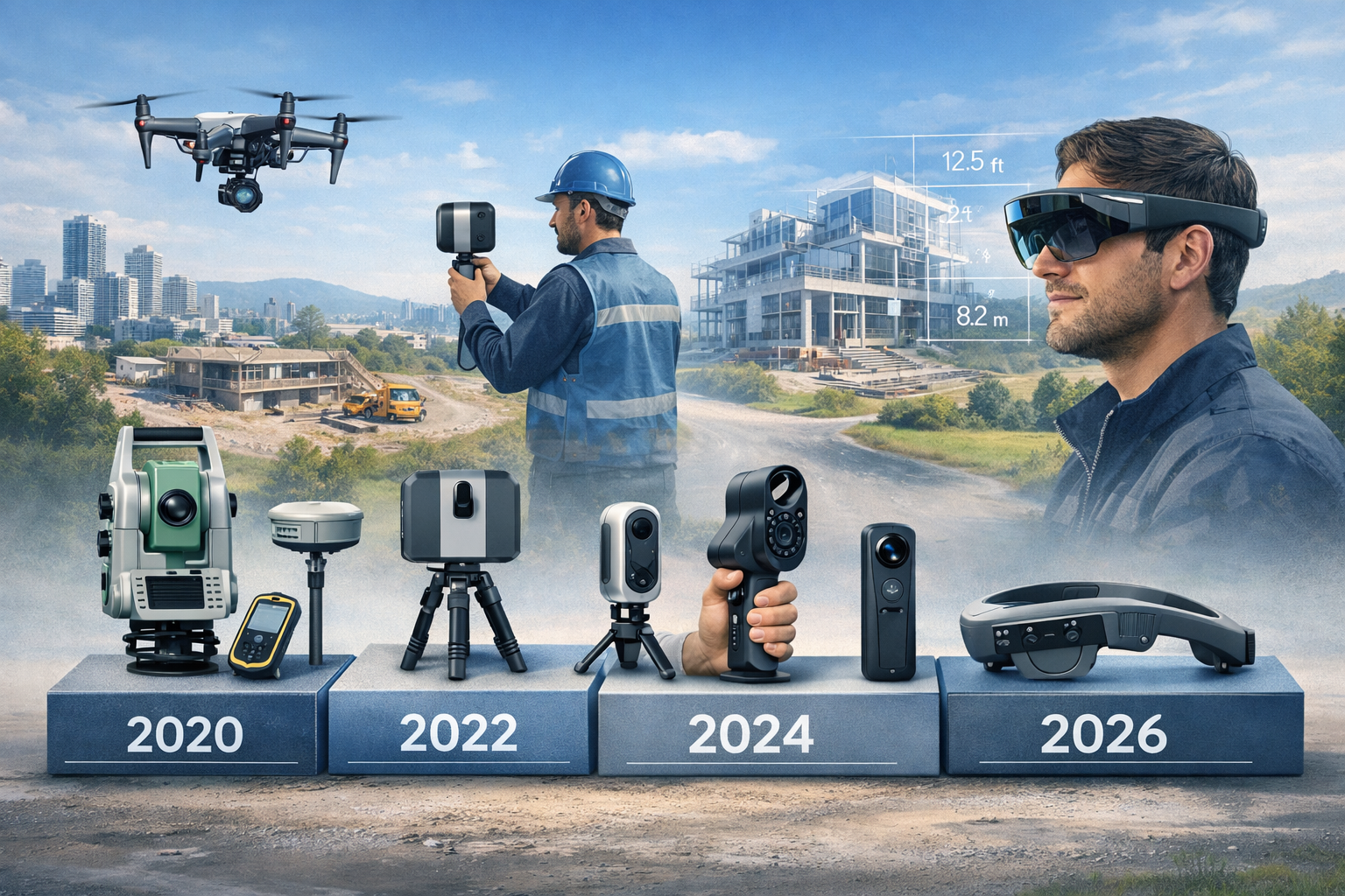
Primary Reality Capture Technologies Now Mainstream
Several distinct technologies have converged to make reality capture practical for everyday surveying work in 2026. Understanding the strengths and appropriate applications of each technology helps surveyors select the right tools for specific project requirements.
LiDAR (Light Detection and Ranging)
LiDAR systems measure distances by illuminating targets with laser light and analyzing the reflected signals. Modern LiDAR scanners for property surveying come in three primary formats:
Terrestrial Laser Scanners (TLS): Tripod-mounted units that capture highly detailed point clouds from stationary positions. These systems excel at documenting complex building interiors, structural engineering assessments, and situations requiring millimeter-level accuracy.
Mobile Mapping Systems: Handheld or backpack-mounted scanners that capture data while the operator walks through spaces. These systems dramatically reduce capture time—a typical residential property that might require 45 minutes with a tripod scanner can be documented in 10-15 minutes with mobile mapping[4].
Drone-Mounted LiDAR: Aerial systems that combine the coverage advantages of photogrammetry with the penetration capabilities of laser scanning, particularly valuable for vegetated sites and large commercial properties.
Photogrammetry and UAV Systems
Photogrammetry creates 3D models from overlapping photographs, with sophisticated software analyzing common features across images to calculate spatial relationships. When combined with drone platforms, photogrammetry offers exceptional cost-effectiveness for exterior documentation and site surveys.
Modern drone systems equipped with RTK (Real-Time Kinematic) and PPK (Post-Processing Kinematic) positioning achieve survey-grade accuracy without ground control points, reducing setup time and enabling rapid deployment[4]. For commercial property surveyors, drones provide safe access to roofs, facades, and other hazardous areas.
GNSS and Positioning Systems
Global Navigation Satellite Systems provide the georeferencing foundation that transforms isolated 3D models into precisely positioned spatial data. RTK-enabled equipment delivers centimeter-level positioning in real-time, essential for integrating reality capture data with existing property boundaries, utility maps, and planning documents.
The Paradigm Shift: From Tools to Lifecycle Value
The maturation of reality capture technology in 2026 represents more than incremental improvements in hardware specifications. Industry leaders now recognize that the fundamental question has shifted from "What can this tool capture?" to "How does this data serve us over time?"[1][2]
This strategic reframing emphasizes:
- Integration across project phases: Using the same digital twin for acquisition due diligence, renovation planning, construction monitoring, and facility management
- Multi-stakeholder accessibility: Enabling architects, contractors, building owners, and local chartered surveyors to work from a common, authoritative data source
- Operational frameworks: Establishing standardized workflows, quality control procedures, and data management protocols that ensure long-term value
- Validation and verification: Implementing systematic approaches to confirm accuracy and reliability of captured data
The Reality Capture Network's sessions at Geo Week 2026 highlighted this evolution, positioning reality capture as a mature, strategic discipline rather than an experimental technology[1][2]. For property surveyors, this means thinking beyond individual project deliverables to consider how reality capture data can support ongoing client relationships and create recurring value.
Accessible Tools Transforming Property Surveys in 2026
The democratization of reality capture technology represents one of the most significant developments in professional surveying. Equipment that cost £100,000+ just five years ago now has functional equivalents available for under £15,000, while entirely new categories of affordable tools have emerged to serve small practices and independent surveyors.
Entry-Level Reality Capture Solutions for Small Firms
Budget Tier (£2,000-£7,000)
For surveyors taking their first steps into reality capture, several compelling options deliver professional results without major capital investment:
-
Smartphone-based LiDAR: Devices like the latest iPhone Pro models include integrated LiDAR sensors capable of capturing room-scale environments with 1-2cm accuracy. While not suitable for all applications, these systems excel at preliminary assessments, client consultations, and supplementary documentation for homebuyer surveys.
-
Consumer drone platforms: Modern drones from DJI and similar manufacturers offer 4K cameras, automated flight planning, and photogrammetry processing for £1,500-£3,500. These systems provide excellent value for roof inspections, site surveys, and exterior documentation.
-
Tablet-based scanning apps: Software solutions that use device cameras and processing to create measured 3D models, suitable for space planning and preliminary assessments.
Mid-Range Tier (£7,000-£20,000)
This category represents the "sweet spot" for many small surveying practices, offering professional-grade performance with manageable investment:
-
Handheld mobile mappers: Devices like the GeoSLAM ZEB series or similar systems capture detailed interior and exterior point clouds while walking, delivering accuracy sufficient for most property surveying applications. These tools excel at stock condition surveys and building documentation.
-
Entry-level terrestrial scanners: Compact laser scanners that provide higher accuracy than mobile systems for situations requiring precise measurements, such as specific defect reports or structural monitoring.
-
RTK-enabled survey drones: Professional UAV platforms with integrated positioning systems that achieve survey-grade accuracy for site mapping and exterior documentation.
Professional-Grade Systems with Small-Firm Accessibility
Advanced Tier (£20,000-£50,000)
For established practices ready to make reality capture central to their service offering, professional systems deliver capabilities that directly compete with larger firms:
-
High-accuracy terrestrial scanners: Systems offering sub-millimeter precision for demanding applications like subsidence monitoring and structural deformation analysis.
-
Integrated mobile mapping platforms: Advanced systems combining LiDAR, photogrammetry, and GNSS positioning for comprehensive site documentation in single passes.
-
Specialized inspection equipment: Thermal imaging drones, ground-penetrating radar, and other technologies that extend reality capture into damp surveys and subsurface investigation.
Software and Processing Solutions
Hardware represents only half of the reality capture equation. Processing software transforms raw sensor data into actionable deliverables, and 2026 has seen remarkable advances in accessibility and automation.
Cloud-Based Processing Platforms
Modern cloud services eliminate the need for expensive workstations and specialized IT expertise. Surveyors upload raw data and receive processed point clouds, 3D models, and measurements without maintaining local processing infrastructure. Subscription models starting at £50-150 monthly make professional processing accessible to practices of all sizes.
AI-Powered Workflow Automation
Artificial intelligence has revolutionized reality capture post-processing, automating tasks that previously consumed hours of manual effort[2]:
- Automatic classification: AI algorithms identify and label building elements (walls, floors, ceilings, doors, windows) within point clouds
- Defect detection: Machine learning systems highlight potential structural issues, damp areas, and anomalies for surveyor review
- Measurement extraction: Automated tools generate floor plans, elevations, and dimension reports from 3D data
- Change detection: Systems compare sequential scans to identify modifications, settlement, or deterioration
These capabilities enable "survey information modeling"—queryable 3D datasets that respond to natural language questions rather than requiring manual navigation[2]. A surveyor might ask "Show me all windows on the north elevation" or "Measure the floor area of all rooms with ceiling heights below 2.1 meters" and receive instant, accurate responses.
Web-Based Digital Twins
Gaussian splats and georeferenced photogrammetry enable web-based digital twins accessible from any device without specialized software[2]. Surveyors can share interactive 3D models with clients, allowing them to virtually "walk through" properties, review specific features, and understand survey findings in intuitive visual context.
This accessibility transforms client communication. Rather than interpreting technical drawings and written reports, property buyers can explore digital replicas of buildings, seeing exactly what the surveyor documented. For commercial building surveys, this transparency builds confidence and reduces misunderstandings.
Integration Across the Property Lifecycle
Modern reality capture systems serve multiple stakeholders throughout a property's operational life, creating value far beyond initial documentation[2]:
Acquisition Phase: Prospective buyers use reality capture for comprehensive due diligence, documenting existing conditions and verifying seller representations. The objective digital record provides protection against disputes and supports informed decision-making[5].
Design and Planning: Architects and engineers work from accurate as-built models rather than outdated drawings or time-consuming manual surveys, reducing design errors and improving renovation feasibility.
Construction Monitoring: Sequential scans track progress, verify compliance with plans, and document conditions at key milestones. Monitoring surveys become routine rather than exceptional.
Facility Management: Building owners maintain digital twins that evolve with modifications, supporting maintenance planning, space management, and future renovation projects.
This lifecycle approach creates recurring engagement opportunities for surveyors who position themselves as long-term data stewards rather than one-time service providers.
Adoption Strategies for Surveying Practices Amid Workforce Challenges

The UK surveying industry faces significant workforce pressures in 2026, with experienced professionals retiring faster than new graduates enter the field. Reality capture technology offers a strategic response, enabling smaller teams to maintain or expand service capacity while delivering enhanced quality and speed.
Building Technological Fluency in Surveying Teams
Successful adoption requires more than equipment purchase—it demands cultural change and skills development. The new generation of surveyors must combine traditional knowledge with digital capabilities[4]:
Essential Competencies for 2026
- Data literacy: Understanding point cloud quality, resolution requirements, and accuracy specifications
- Technology selection: Matching capture methods to project requirements and budget constraints
- Quality assurance: Validating digital data through systematic checking and field verification
- Digital communication: Presenting 3D data and findings to clients unfamiliar with technical visualization
- Workflow integration: Incorporating reality capture into existing business processes efficiently
Practical Implementation Roadmap for Small Firms
Firms considering reality capture adoption benefit from phased approaches that minimize risk while building capabilities:
Phase 1: Pilot Projects and Skills Development (Months 1-3)
Objectives: Gain hands-on experience, identify workflow challenges, and demonstrate value to early-adopter clients.
Actions:
- Select entry-level equipment appropriate to primary service offerings
- Identify 3-5 pilot projects representing typical work (consider offering discounted rates in exchange for learning opportunities)
- Invest in formal training—manufacturer courses, professional development programs, or mentorship from experienced users
- Document time savings, accuracy improvements, and client feedback systematically
Success Metrics: Complete pilot projects successfully, achieve client satisfaction, and identify specific efficiency gains.
Phase 2: Process Standardization (Months 4-6)
Objectives: Develop repeatable workflows, quality standards, and pricing structures.
Actions:
- Create standard operating procedures for common project types
- Establish quality control checklists and validation protocols
- Develop template deliverables and presentation formats
- Calculate accurate cost-per-project including equipment depreciation, processing time, and field capture
- Update service descriptions and marketing materials to highlight reality capture capabilities
Success Metrics: Consistent project execution, predictable timelines, and profitable pricing.
Phase 3: Service Expansion and Differentiation (Months 7-12)
Objectives: Leverage reality capture as competitive differentiator and revenue growth driver.
Actions:
- Introduce premium service tiers incorporating advanced deliverables (digital twins, BIM models, monitoring programs)
- Target client segments that particularly value reality capture (property investors, commercial landlords, heritage buildings)
- Develop partnerships with architects, contractors, and facility managers who need regular access to accurate spatial data
- Consider specialized applications like dilapidations surveys or lease documentation
Success Metrics: Revenue growth from reality capture services, improved client retention, and enhanced market positioning.
Addressing Workforce Shortages Through Technology
Reality capture directly mitigates workforce constraints in several ways:
Productivity Multiplication: A single surveyor with mobile mapping equipment can document properties at rates previously requiring three-person teams using traditional methods. Projects that consumed full days now complete in hours, allowing practices to serve more clients without additional hiring[4].
Knowledge Retention: Digital records preserve site conditions comprehensively, reducing dependence on individual surveyors' memory and notes. Junior staff can review captured data with senior guidance, accelerating skill development.
Reduced Physical Demands: Mobile scanning and drone deployment require less climbing, crawling, and working in confined spaces than traditional inspection methods, making surveying more accessible to diverse practitioners and extending career longevity.
Remote Collaboration: Cloud-based data sharing enables distributed teams to collaborate effectively. A field surveyor captures data while office-based specialists handle processing and reporting, optimizing resource allocation.
Investment Justification and ROI Calculation
Convincing practice principals or partners to invest in reality capture requires clear financial justification. The business case typically rests on three pillars:
Time Savings: Mobile mapping systems reduce on-site time by 60-70% compared to traditional methods[4]. For a practice charging £800-1,200 per day for surveyor time, completing projects in 1.5 days instead of 4 days creates immediate margin improvement or capacity for additional projects.
Service Premium: Clients increasingly expect or demand 3D deliverables, particularly for commercial properties and investment acquisitions. Practices can command 15-30% premiums for reality capture-enhanced reports while delivering superior value.
Competitive Necessity: As reality capture becomes standard rather than exceptional, practices without these capabilities face competitive disadvantage. The question shifts from "Can we afford to invest?" to "Can we afford not to?"
Example ROI Scenario for £15,000 Mobile Mapping Investment:
| Factor | Traditional Method | Reality Capture | Improvement |
|---|---|---|---|
| Average project duration | 3.5 days | 1.2 days | 66% reduction |
| Projects per month | 6 | 14 | 133% increase |
| Average project fee | £1,200 | £1,400 | 17% premium |
| Monthly revenue | £7,200 | £19,600 | 172% increase |
| Equipment payback period | N/A | 2.1 months | Fast ROI |
Assumptions: Single surveyor practice, existing client base, conservative adoption rate
Training and Professional Development Resources
Multiple pathways support surveyors developing reality capture competencies:
- Manufacturer training programs: Equipment vendors offer comprehensive courses covering operation, processing, and best practices
- Professional associations: RICS and similar organizations provide CPD modules and certification programs
- Online learning platforms: Specialized courses in photogrammetry, point cloud processing, and digital surveying
- Peer learning networks: Industry forums, user groups, and conferences like Geo Week facilitate knowledge sharing
- Vendor partnerships: Many suppliers offer ongoing support, workflow consultation, and application expertise
The most successful adopters combine formal training with hands-on experimentation, allocating dedicated time for skills development rather than expecting proficiency to emerge organically.
Precision, Safety, and Speed: The Practical Benefits
Beyond competitive positioning and workflow efficiency, reality capture delivers tangible improvements in three critical areas that directly impact project outcomes and professional liability.
Precision and Accuracy Advantages
Modern reality capture systems achieve measurement accuracy that exceeds traditional methods while documenting far more comprehensive data:
Millimeter-Level Precision: Professional terrestrial scanners deliver point spacing of 1-3mm at typical room distances, capturing subtle surface variations, deformation, and defects invisible to manual measurement. This precision proves invaluable for structural engineering assessments and heritage building documentation.
Comprehensive Coverage: Traditional surveys measure specific points and dimensions identified during site visits. Reality capture documents everything within sensor range, preserving details that may prove significant during later analysis. Discovering an unmeasured feature no longer requires return visits—the data already exists in the point cloud.
Objective Documentation: Digital records eliminate subjective interpretation and measurement errors. When disputes arise about pre-existing conditions or damage attribution, georeferenced point clouds provide definitive evidence. This objectivity particularly benefits party wall surveys and condition documentation.
Repeatability and Monitoring: Sequential scans enable precise comparison over time, quantifying settlement, deformation, or deterioration with sub-millimeter sensitivity. Automated change detection highlights modifications without manual comparison, supporting monitoring surveys and structural observation.
Enhanced Safety for Surveyors and Site Personnel
Reality capture technologies reduce or eliminate many hazardous aspects of traditional surveying:
Aerial Inspection Without Access: Drones document roofs, chimneys, facades, and other elevated features without ladders, scaffolding, or harnesses. This capability proves particularly valuable for preliminary assessments, where the safety risk of physical access may outweigh the information value.
Standoff Measurement: LiDAR systems capture accurate data from safe distances, eliminating the need to approach unstable structures, contaminated areas, or active construction zones. Surveyors can document hazardous conditions while maintaining appropriate safety margins.
Reduced Time in Hazardous Environments: Mobile mapping's speed advantage means surveyors spend less time in confined spaces, areas with poor air quality, or locations with structural concerns. A basement damp survey that might require 45 minutes of traditional inspection can be captured in 10 minutes, reducing exposure to mold, asbestos dust, or structural hazards.
Traffic Management Benefits: For surveys involving roadways or active sites, rapid data capture minimizes the duration of traffic control, lane closures, or work interruptions, reducing accident risk and site disruption.
Accelerated Project Timelines
Speed advantages extend throughout the project lifecycle, from initial site visit to final deliverable:
Field Capture Efficiency: Mobile mapping systems document typical residential properties in 10-20 minutes, with commercial buildings requiring proportionally scaled time based on size and complexity[4]. This efficiency enables same-day multi-property surveys or rapid response to urgent client requests.
Reduced Site Visits: Comprehensive digital capture often eliminates the need for return visits to verify measurements or document additional features. Surveyors can "revisit" properties virtually, extracting measurements and observations from office-based point cloud review.
Parallel Processing: While surveyors capture new sites, cloud processing systems handle previous projects simultaneously. This parallelization accelerates overall throughput compared to sequential traditional workflows.
Faster Client Decision-Making: Interactive 3D models and visual documentation help clients understand findings quickly, reducing the explanation time and follow-up questions that often delay traditional report review. For time-sensitive transactions, this acceleration can prove decisive.
Streamlined Collaboration: When multiple professionals need site information—architects planning renovations, engineers assessing structures, contractors estimating work—a shared digital twin eliminates coordination delays and conflicting measurements. All stakeholders work from identical, authoritative data.
Real-World Application: Property Acquisition Due Diligence
The value proposition crystallizes in practical application. Consider a property investor evaluating a commercial building purchase:
Traditional Approach: Multiple site visits by different specialists (surveyor, structural engineer, M&E consultant), each conducting independent inspections and measurements. Timeline: 2-3 weeks from initial instruction to compiled reports. Cost: £8,000-12,000. Risk: Potential for missed defects or measurement discrepancies between consultants.
Reality Capture Approach: Single comprehensive scan capture (2-3 hours on-site), with digital twin shared among all consultants for remote analysis. Sequential thermal imaging and visual inspection drone flights document roof and facades. Timeline: 5-7 days from instruction to compiled reports. Cost: £6,000-9,000. Benefits: Complete digital record for future reference, precise measurements available indefinitely, reduced site disruption[5].
The objective digital record provides ongoing value beyond initial due diligence, supporting renovation planning, lease documentation, and future condition monitoring from the same dataset[5].
The Future Landscape: AI, Integration, and Evolving Surveyor Roles
Reality capture's mainstream adoption in 2026 represents a beginning rather than an endpoint. Emerging technologies and evolving client expectations continue reshaping the surveying profession's trajectory.
AI as Enhancement Rather Than Replacement
Artificial intelligence significantly enhances surveying capabilities while reinforcing rather than diminishing the need for professional judgment[4]:
Automated Data Processing: AI algorithms handle repetitive classification, measurement extraction, and quality checking tasks, freeing surveyors to focus on interpretation, analysis, and client consultation. What previously consumed hours of manual work now completes in minutes, but the surveyor's expertise remains essential for validating results and identifying anomalies.
Intelligent Defect Detection: Machine learning systems trained on thousands of building surveys can highlight potential issues—unusual thermal patterns, structural deformation, moisture intrusion—but surveyors must evaluate significance, determine causation, and recommend remediation. AI provides augmented perception, not autonomous diagnosis.
Predictive Analysis: Advanced systems analyze historical data to forecast maintenance needs, deterioration rates, and lifecycle costs. These capabilities create new advisory opportunities for surveyors who develop expertise in interpreting and communicating AI-generated insights.
Natural Language Interaction: Query-based interfaces allow surveyors and clients to ask questions of 3D datasets in plain language: "What's the floor-to-ceiling height in the northwest bedroom?" or "Show me all areas with potential damp issues." This accessibility democratizes data access while maintaining professional oversight[2].
The consensus among industry leaders is clear: AI will transform surveying workflows but not eliminate the need for skilled professionals. Decision-making, legal compliance, client relationship management, and complex field conditions require human expertise that technology augments rather than replaces[4].
Standardization and Operational Frameworks
As reality capture matures, success increasingly depends on operational excellence rather than technological novelty[1]:
Industry Standards Development: Professional bodies and industry consortia are establishing standards for data quality, deliverable formats, and validation procedures. Surveyors adopting these standards position themselves as reliable, professional practitioners rather than experimental technology enthusiasts.
Quality Assurance Protocols: Systematic approaches to verifying accuracy, completeness, and reliability of captured data build client confidence and reduce professional liability exposure. Leading practices implement multi-stage checking procedures and maintain documented validation records.
Data Management Systems: As firms accumulate libraries of digital twins and point clouds, organized storage, version control, and retrieval systems become essential. Cloud-based platforms with robust metadata and search capabilities ensure historical data remains accessible and valuable.
Interoperability Requirements: Clients and collaborators increasingly expect data in standardized formats compatible with BIM platforms, CAD systems, and facility management software. Surveyors must understand format requirements and conversion workflows to deliver maximum value.
Emerging Service Models and Revenue Opportunities
Reality capture enables surveying practices to expand beyond traditional transaction-based services:
Subscription Monitoring Programs: Offering ongoing condition monitoring for commercial portfolios, heritage buildings, or structures with known issues creates recurring revenue and deepens client relationships. Quarterly or annual scanning detects changes early, supporting proactive maintenance.
Digital Twin Management: Maintaining and updating building digital twins as modifications occur positions surveyors as long-term data stewards. Property owners gain authoritative as-built records while surveyors establish continuous engagement.
Specialized Applications: Niche opportunities emerge in areas like insurance claims documentation, lease dispute resolution, heritage conservation, and construction quality verification. Reality capture's objective evidence proves particularly valuable in contested situations.
Data Analytics Services: Analyzing captured data to identify patterns, optimize space utilization, or forecast maintenance needs adds advisory value beyond documentation. Surveyors with analytical skills can command premium fees for strategic insights.
Preparing for Continued Innovation
The pace of technological change shows no signs of slowing. Surveying practices that thrive will cultivate organizational cultures of continuous learning and adaptation:
Technology Monitoring: Allocating time to evaluate emerging tools, attend industry conferences, and engage with vendor roadmaps ensures practices don't fall behind as capabilities evolve.
Flexible Investment Strategies: Leasing equipment, using cloud-based services, and maintaining upgrade paths minimize the risk of technological obsolescence while enabling access to current capabilities.
Skills Development Programs: Systematic professional development ensures team members maintain relevant competencies as tools and methods evolve. The most successful practices view training as ongoing investment rather than one-time expense.
Client Education: Helping clients understand reality capture's value, interpret deliverables, and leverage digital data effectively differentiates practices and builds loyalty. Educated clients become advocates who drive referrals and repeat business.
Conclusion: Embracing the Reality Capture Revolution
Reality capture goes mainstream: accessible tools for property surveyors in 2026 represents far more than a technological trend—it marks a fundamental transformation in how surveying professionals document, analyze, and serve clients. The barriers that once confined these capabilities to large firms with specialized departments have dissolved, creating unprecedented opportunities for practices of all sizes.
The evidence is compelling: mobile mapping systems reduce field time by 60-70% while improving accuracy and safety[4]. AI-powered processing automates tedious tasks, allowing surveyors to focus on professional judgment and client service[2]. Cloud-based platforms eliminate infrastructure requirements, making professional-grade capabilities accessible through affordable subscriptions. Most significantly, reality capture addresses the industry's workforce challenges by enabling smaller teams to accomplish more while delivering enhanced quality.
Yet technology alone guarantees nothing. Success requires strategic implementation, skills development, and organizational commitment. The practices that will thrive in this evolving landscape are those that:
✅ Invest systematically in equipment, training, and process development rather than pursuing technology for its own sake
✅ Focus on client value by understanding how reality capture solves specific problems and communicates findings effectively
✅ Build operational excellence through standardized workflows, quality assurance protocols, and data management systems
✅ Cultivate continuous learning to keep pace with accelerating innovation and evolving client expectations
✅ Position strategically by identifying niches, service differentiators, and market segments where reality capture creates competitive advantage
Actionable Next Steps for Surveying Practices
For practices beginning their reality capture journey:
- Assess current capabilities and gaps: Identify which projects would benefit most from reality capture and what equipment/skills are needed
- Start with achievable pilots: Select entry-level equipment appropriate to your primary services and test on 3-5 projects
- Invest in training: Prioritize formal education over trial-and-error to accelerate competency development
- Document results systematically: Track time savings, accuracy improvements, and client feedback to build business case for expansion
For practices with initial reality capture experience:
- Standardize workflows: Develop repeatable processes, quality standards, and template deliverables
- Expand service offerings: Introduce premium tiers, specialized applications, or monitoring programs
- Strengthen partnerships: Collaborate with architects, engineers, and contractors who need regular access to spatial data
- Upgrade strategically: Evaluate whether advanced equipment or specialized software would unlock new opportunities
For practices seeking competitive differentiation:
- Develop specialized expertise: Focus on applications like heritage conservation, commercial portfolios, or construction monitoring
- Implement lifecycle service models: Position as long-term data stewards rather than transaction-based providers
- Leverage AI capabilities: Adopt advanced processing tools that deliver unique insights and efficiency
- Lead industry standards: Participate in professional development, contribute to best practices, and establish thought leadership
The surveying profession stands at a pivotal moment. Reality capture technology has matured to the point where adoption is no longer experimental—it's becoming essential for competitive survival. The practices that recognize this reality and act decisively will find themselves well-positioned to serve clients effectively, operate efficiently, and thrive amid ongoing industry transformation.
The tools are accessible. The benefits are proven. The time to act is now. Whether you're conducting homebuyer surveys, commercial building assessments, or specialized investigations, reality capture offers pathways to deliver superior service while building sustainable, future-ready surveying practices.
The mainstream adoption of reality capture in 2026 isn't just changing how surveyors work—it's redefining what's possible in property documentation, analysis, and client service. The question facing every surveying practice is simple: Will you lead this transformation or be left behind by it?
References
[1] Geo Week 2026 Highlights Reality Capture S Strategic Role – https://www.gim-international.com/content/news/geo-week-2026-highlights-reality-capture-s-strategic-role
[2] Reality Capture Network At Geo Week 2026 A Focus On Integration Precision And Enduring Data Value – https://www.geoweeknews.com/news/reality-capture-network-at-geo-week-2026-a-focus-on-integration-precision-and-enduring-data-value
[3] Reality Capture Goes Mainstream Accessible Tools Transforming Property Surveys In 2026 – https://nottinghillsurveyors.com/blog/reality-capture-goes-mainstream-accessible-tools-transforming-property-surveys-in-2026
[4] The Future Of Land Surveying Technology And Upcoming Trends In 2026 – https://metricop.com/blogs/land-surveying/the-future-of-land-surveying-technology-and-upcoming-trends-in-2026
[5] Reality Capture Due Diligence Property Acquisition – https://www.geo-scan.uk/insights/reality-capture-due-diligence-property-acquisition
[6] Powering The Future With Precision Verdantas Reality Capture Solutions For The – https://www.verdantas.com/news-insights/article/3533/powering-the-future-with-precision-verdantas-reality-capture-solutions-for-the
[7] 62515 Why Visual Intelligence Is The Next Big Shift In Construction Technology – https://www.enr.com/articles/62515-why-visual-intelligence-is-the-next-big-shift-in-construction-technology
[8] Reality Capture And Laser Scanning – https://www.henselphelps.com/reality-capture-and-laser-scanning/
[9] 3d Mapping And Visualization Tools Making Advanced Surveying Technology Accessible And Affordable – https://nottinghillsurveyors.com/blog/3d-mapping-and-visualization-tools-making-advanced-surveying-technology-accessible-and-affordable