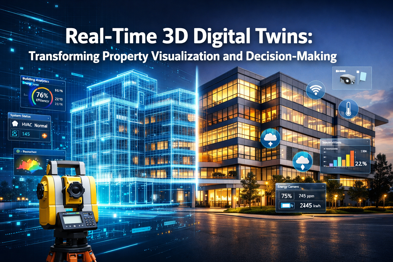
Imagine standing in an empty construction site while simultaneously exploring every room, testing different layouts, and monitoring energy consumption—all before a single brick is laid. This isn't science fiction; it's the reality that Real-Time 3D Digital Twins: Transforming Property Visualization and Decision-Making brings to the property sector in 2026. 🏗️
As the construction and real estate industries embrace digital transformation, 3D digital twins have emerged as revolutionary tools that create dynamic virtual representations of physical properties. Unlike static 3D models that capture a single moment in time, digital twins continuously update with real-time data from sensors and IoT devices, functioning as interactive mirrors that reflect the current state of their physical counterparts[1]. This technology is fundamentally changing how developers, engineers, surveyors, and property managers approach visualization, planning, and operational decision-making.
The year 2026 marks a pivotal transition point where digital twins move from experimental phases into mainstream building operations[7]. With companies achieving 10-20% reductions in operating costs through improved predictive maintenance and performance monitoring[4], the business case for adoption has never been stronger. For chartered surveyors and construction professionals, understanding how to implement and leverage these continuous-updating models has become essential to remaining competitive.
Key Takeaways
- Digital twins are dynamic virtual replicas that continuously update with real-time data from IoT sensors, distinguishing them from static 3D models through live operational intelligence and predictive analytics capabilities
- Cost reduction of 10-20% is achievable through digital twin implementation in construction and facility operations, primarily through enhanced predictive maintenance and performance optimization[4]
- Three core technical components power digital twins: sensors collecting live data, 3D visualization tools (CAD/BIM) creating interactive models, and machine learning analytics predicting outcomes and optimizing performance[1]
- Cloud-based platforms like Autodesk Construction Cloud, Matterport, and Cupix enable surveyors to create and manage digital twins through LiDAR scanning, photogrammetry, and IoT integration[3]
- 2026 represents mainstream adoption as digital twins transition from visualization tools to comprehensive smart building operations platforms integrating energy systems, security, and ESG reporting[7]
Understanding Real-Time 3D Digital Twins: Transforming Property Visualization and Decision-Making
What Makes a Digital Twin "Real-Time"?
A 3D digital twin is far more sophisticated than a traditional 3D model or architectural rendering. While conventional models provide static visual representations, digital twins create living, breathing virtual environments that mirror their physical counterparts in real time[1]. The "real-time" aspect refers to the continuous flow of data from physical sensors into the virtual model, enabling the digital representation to reflect current conditions, usage patterns, and operational status.
This continuous updating capability transforms digital twins into powerful decision-making tools rather than mere visualization aids. When temperature sensors detect anomalies, occupancy monitors track building usage, or energy meters record consumption spikes, these data points immediately update the virtual model. Property managers can inspect and navigate building areas without physical site presence, while engineers can identify potential issues before they escalate into costly problems[1].
The integration of photorealistic visualization with live operational data creates an unprecedented level of situational awareness. For structural surveys, this means surveyors can monitor building performance over time, validating assumptions and identifying structural changes that might indicate problems like subsidence or settlement.
The Three Essential Technical Components
Digital twins operate through three interconnected technical systems that work together to create comprehensive virtual representations[1]:
| Component | Function | Examples |
|---|---|---|
| Sensors & IoT Devices | Collect live data from physical environment | Temperature sensors, occupancy monitors, energy meters, humidity sensors, structural strain gauges |
| 3D Visualization Tools | Create interactive virtual models | CAD software, Building Information Modeling (BIM), photogrammetry, LiDAR scanning |
| Machine Learning Analytics | Predict outcomes and optimize performance | Predictive maintenance algorithms, energy optimization models, occupancy forecasting |
Sensors and IoT devices form the nervous system of digital twins, constantly gathering information about the physical property. These devices measure everything from temperature and humidity to structural stress and energy consumption. The data flows continuously into the digital model, ensuring the virtual representation stays synchronized with reality.
3D visualization tools create the visual framework that makes digital twins accessible and understandable. Technologies like Building Information Modeling (BIM) provide detailed architectural and engineering information, while LiDAR scanning and photogrammetry capture precise geometric data. When integrated with Canterbury property valuation processes, these visualization capabilities enable more accurate assessments based on comprehensive building data.
Machine learning analytics transform raw data into actionable insights. These systems identify patterns, predict future conditions, and recommend optimizations. For example, machine learning algorithms can analyze historical energy usage patterns to predict future consumption, identify inefficiencies, and suggest improvements that reduce operating costs.
How Digital Twins Differ from Traditional BIM Models
While Building Information Modeling (BIM) and digital twins share common foundations, they serve different purposes and operate at different levels of sophistication. BIM models are primarily design and construction tools that contain detailed information about building components, materials, and specifications. They excel at coordination during construction but typically remain static after project completion.
Digital twins, by contrast, extend beyond the construction phase into the entire building lifecycle. They incorporate BIM data as a foundation but add layers of real-time operational intelligence, sensor integration, and predictive analytics[1]. This makes digital twins particularly valuable for facility management, where understanding current building performance is as important as knowing original design specifications.
The distinction becomes clearer when considering practical applications. A BIM model helps engineers calculate beam calculations during design, but a digital twin monitors actual structural performance over years of operation, detecting deviations from expected behavior that might indicate problems.
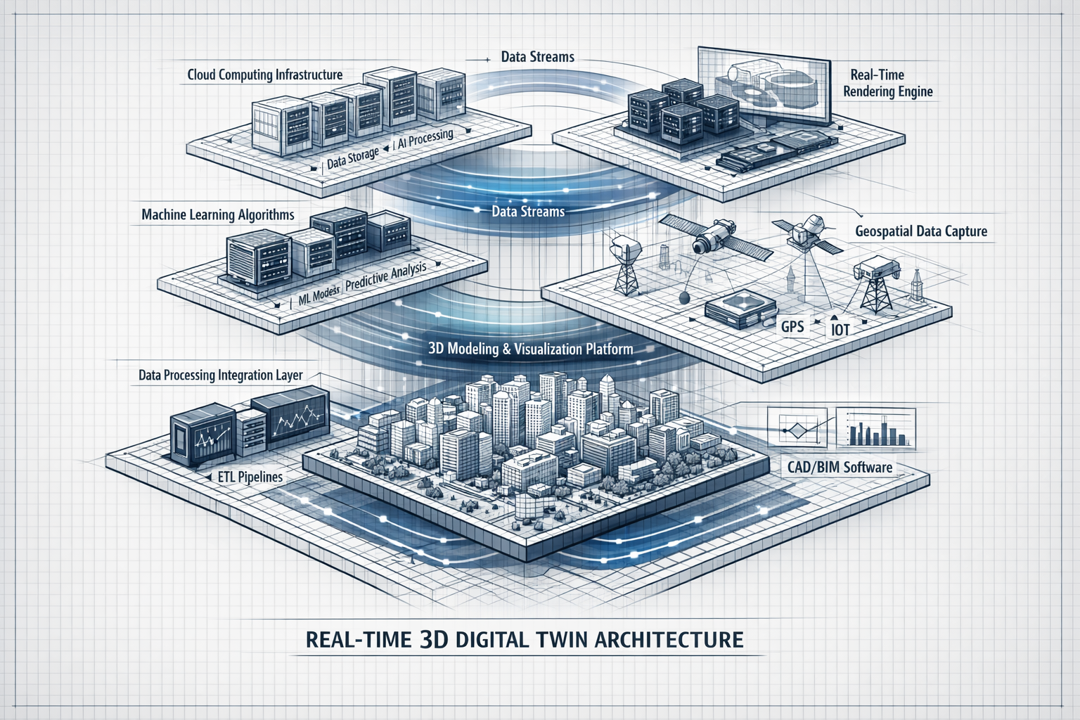
The Technical Architecture Behind Real-Time 3D Digital Twins
Data Capture: Scanning and Imaging Technologies
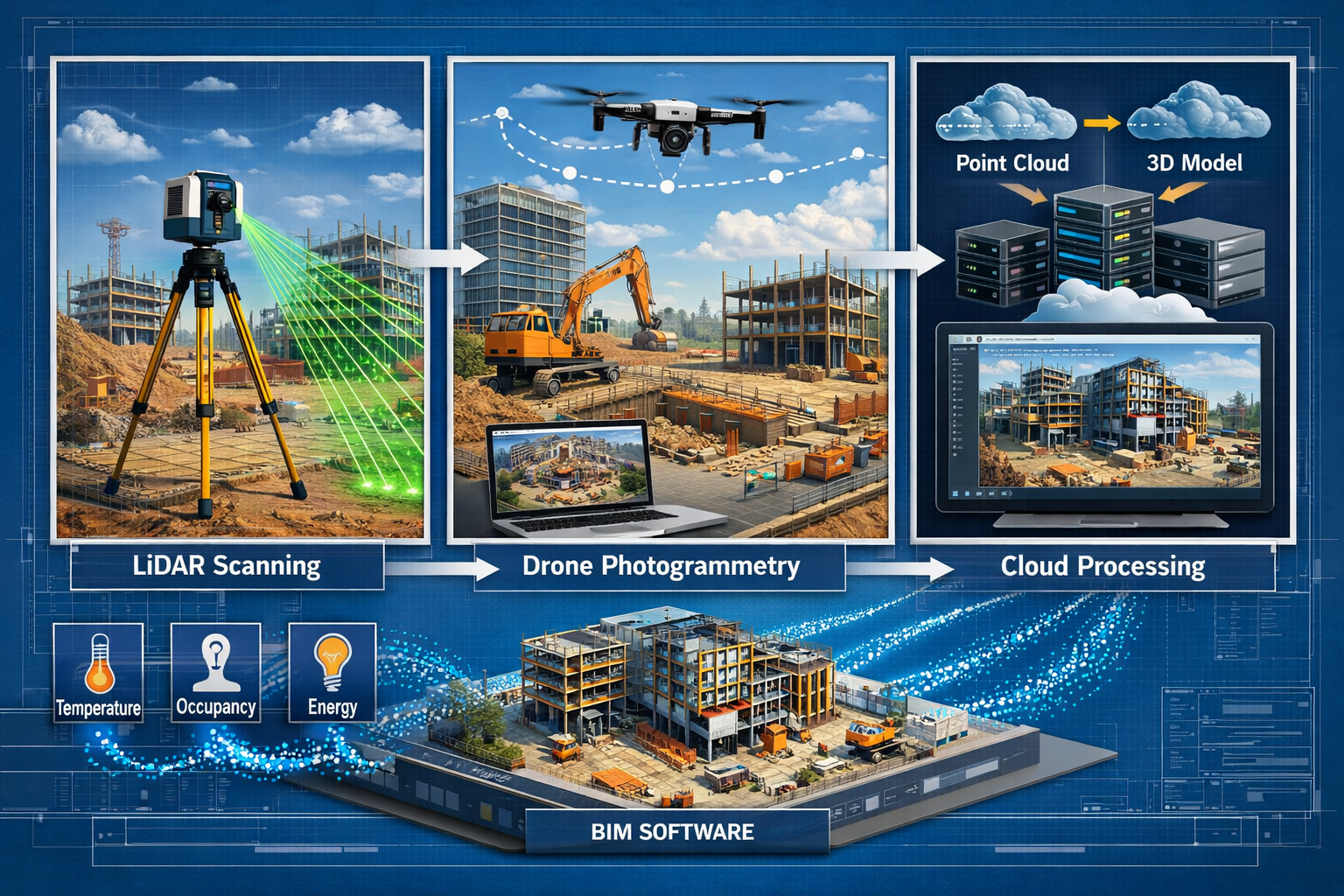
Creating accurate digital twins begins with comprehensive data capture of the physical environment. Modern surveying professionals employ multiple technologies to build detailed virtual representations[1]:
LiDAR (Light Detection and Ranging) uses laser pulses to measure distances with millimeter precision. LiDAR scanners create "point clouds"—collections of millions of individual measurements that collectively define the three-dimensional geometry of a space. For existing buildings, LiDAR provides accurate as-built documentation that often reveals discrepancies between original plans and current conditions.
Photogrammetry captures overlapping photographs from multiple angles and uses computer algorithms to extract three-dimensional information. Drones equipped with high-resolution cameras can quickly survey large properties, generating both geometric data and photorealistic textures. This technology proves particularly valuable for roof surveys and exterior condition assessments.
360-degree cameras capture immersive panoramic imagery that provides contextual understanding of spaces. When integrated with point cloud data, these images create navigable virtual environments where users can "walk through" properties remotely.
The combination of these technologies creates comprehensive digital representations. Regular scanning validates digital twin accuracy over time, creating a feedback loop that maintains alignment between virtual models and physical reality[4]. This ongoing validation process is essential for applications requiring high precision, such as monitoring structural movement or tracking construction progress.
Converting Raw Data into Interactive 3D Models
Raw scan data requires significant processing before becoming useful digital twins. The conversion process involves several technical steps[1]:
-
Point Cloud Processing: Raw LiDAR scans contain millions of individual points that must be cleaned, aligned, and registered. Software removes noise, eliminates redundant data, and combines multiple scans into unified models.
-
Mesh Generation: Point clouds are converted into continuous surfaces (meshes) that define object boundaries and shapes. This process creates the geometric foundation for the digital twin.
-
Texture Mapping: Photographic imagery is projected onto 3D geometry, creating photorealistic appearances. This step transforms abstract geometric models into recognizable virtual environments.
-
Object Recognition and Semantic Enrichment: Advanced algorithms identify building components (walls, doors, windows, mechanical equipment) and assign metadata. This semantic information enables intelligent queries and analysis.
-
BIM Integration: Processed 3D data is connected to BIM databases containing specifications, materials, and engineering information. This integration creates comprehensive information models that combine visual representation with technical documentation.
For surveyors conducting homebuyer surveys or specific defect reports, this processing workflow enables detailed documentation of property conditions with unprecedented accuracy and completeness.
IoT Integration: Streaming Real-Time Sensor Data
The transformation from static 3D model to living digital twin occurs through IoT integration. Sensors installed throughout properties continuously stream data into cloud platforms where it's processed and visualized[1]:
Environmental sensors monitor temperature, humidity, air quality, and lighting conditions. This data enables facility managers to optimize comfort while minimizing energy consumption.
Occupancy sensors track how spaces are used, identifying underutilized areas and informing space planning decisions. In commercial properties, this information supports flexible workspace strategies and helps maximize rental income.
Energy meters measure electricity, gas, and water consumption at granular levels, enabling detailed analysis of usage patterns and identification of waste.
Structural monitoring systems use strain gauges, tilt sensors, and vibration monitors to detect movement or stress that might indicate structural issues. This capability is particularly valuable for monitoring buildings adjacent to construction sites where party wall work or excavation might cause settlement.
Security and fire systems integrate with digital twins to enhance situational awareness, showing the precise location of alarms, access events, or emergency situations on virtual building models[5].
The streaming architecture typically employs edge computing for preliminary data processing at sensor locations, reducing bandwidth requirements and enabling faster response times. Processed data then flows to cloud platforms where it's stored, analyzed, and made available to the digital twin visualization system[1].
Cloud and Edge Computing Architecture
The computational demands of digital twins require sophisticated infrastructure that balances processing power, storage capacity, and network efficiency[1]:
Cloud platforms provide scalable storage for massive point cloud datasets, high-resolution imagery, and historical sensor data. They also host the machine learning models that analyze patterns and generate predictions. Major platforms supporting digital twin applications include Autodesk Construction Cloud, which converts construction sites into digital models, and specialized solutions like Cupix for drone and laser scanner-based site scanning[3].
Edge computing processes time-sensitive data locally, enabling rapid responses without cloud round-trips. For example, security alerts or equipment failures trigger immediate notifications rather than waiting for cloud processing.
Hybrid architectures combine cloud and edge computing to optimize performance and cost. Frequently accessed data and real-time visualizations run on edge servers for low latency, while comprehensive analytics and long-term storage utilize cloud resources.
This infrastructure enables collaborative workflows where multiple stakeholders—architects, engineers, contractors, facility managers—access and interact with digital twins simultaneously. Version control and permission management ensure data integrity while supporting distributed teams.
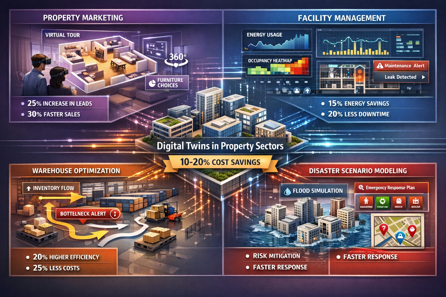
Practical Applications: Real-Time 3D Digital Twins Transforming Property Visualization and Decision-Making
Property Marketing and Pre-Construction Visualization
Digital twins revolutionize how properties are marketed before construction completion. Interactive virtual tours enable prospective tenants or investors to explore buildings remotely, experiencing spaces with photorealistic detail[1]. Unlike traditional renderings that show predetermined views, digital twin tours allow users to navigate freely, examining details from any angle.
Furniture arrangement testing helps potential occupants visualize how their belongings will fit in spaces. Users can place virtual furniture, experiment with layouts, and make informed decisions about space suitability before signing leases or purchase agreements.
Daylight simulation demonstrates how natural light varies throughout the day and across seasons. This capability addresses one of the most important factors in property appeal, allowing buyers to understand lighting conditions they would otherwise need to experience over multiple visits.
Layout customization enables buyers to evaluate different configuration options, comparing open-plan versus divided spaces, or testing various partition arrangements. This interactive exploration increases buyer confidence and reduces post-purchase modifications.
For property valuations, including desktop house valuations, digital twins provide comprehensive documentation that supports more accurate assessments. Valuers can virtually inspect properties, measure spaces precisely, and evaluate condition without physical visits, increasing efficiency while maintaining accuracy.
Facility Management and Building Operations
Property managers leverage digital twins to monitor occupancy, energy usage, and maintenance needs in real time[1]. Dashboard interfaces display building status at a glance, highlighting areas requiring attention and enabling proactive management.
Predictive maintenance uses sensor data and machine learning to forecast equipment failures before they occur. By analyzing patterns in vibration, temperature, or performance metrics, digital twins identify components approaching failure, allowing scheduled maintenance that prevents costly emergency repairs and operational disruptions.
Energy optimization represents one of the most significant cost-saving applications. Digital twins identify inefficiencies by comparing actual consumption against benchmarks and simulations. They can test optimization strategies virtually before implementation, ensuring changes deliver expected benefits. Modern platforms integrate energy systems for faster anomaly detection and carbon tracking to support ESG reporting requirements[5].
Space utilization analysis helps organizations maximize real estate value. By tracking how spaces are actually used versus how they're allocated, facility managers can reconfigure layouts, implement hot-desking strategies, or identify opportunities to reduce leased space.
Maintenance workflow optimization streamlines repair and service activities. When issues arise, maintenance staff can access the digital twin to understand equipment locations, review specifications, and plan work before arriving on site. This preparation reduces time spent troubleshooting and improves first-time fix rates.
For commercial properties requiring commercial valuations or dilapidations surveys, digital twins provide comprehensive documentation of building conditions and maintenance history, supporting more accurate assessments and dispute resolution.
Construction Progress Monitoring and Quality Control
Digital twins transform construction management by providing continuous visibility into project status. Regular scanning—weekly or even daily on large projects—captures as-built conditions that are compared against design models to identify discrepancies[4].
Progress tracking becomes objective and quantifiable. Rather than relying on subjective assessments or manual measurements, project managers compare current conditions against planned schedules, automatically calculating completion percentages and identifying delays.
Quality control improves through systematic comparison of as-built conditions against specifications. Deviations are flagged immediately, enabling corrections while work is still accessible rather than discovering problems after finishes are installed.
Clash detection identifies conflicts between different building systems before installation. When mechanical, electrical, and plumbing systems are modeled in their actual locations, coordination issues become apparent, preventing costly rework.
Safety monitoring uses digital twins to track site conditions, identify hazards, and plan safe work sequences. Excavation depths, temporary structures, and access routes can be monitored remotely, reducing the need for personnel to enter potentially dangerous areas.
This monitoring capability proves particularly valuable for complex projects involving structural engineering coordination or party wall loft conversions where precise execution is critical.
Warehouse and Logistics Optimization
Digital twins enable warehouse operators to visualize facility workflows, test inventory flow patterns, and identify bottlenecks before they become operational problems[3]. This application demonstrates how digital twins extend beyond traditional buildings into specialized facilities.
Layout optimization tests different storage configurations, picking routes, and equipment placements virtually. Operators can simulate various scenarios, comparing efficiency metrics to identify optimal arrangements before moving physical inventory or equipment.
Capacity planning models how changes in inventory levels or product mix affect space requirements and throughput. This forward-looking capability supports strategic decisions about facility expansion, automation investments, or operational changes.
Equipment utilization tracking monitors forklifts, conveyors, and automated systems in real time, identifying underutilized assets or bottlenecks that constrain throughput.
Safety analysis simulates pedestrian and vehicle movements, identifying potential collision points and evaluating traffic management strategies.
Emergency Planning and Disaster Scenario Modeling
Digital twins allow city planners, emergency managers, and property owners to model potential impacts of floods, hurricanes, and other natural disasters on buildings and infrastructure[3]. This capability transforms emergency preparedness from reactive to proactive.
Flood simulation models water levels, flow patterns, and structural impacts under various storm scenarios. Property owners can evaluate flood protection measures virtually, testing barriers, drainage improvements, or elevation strategies before investing in physical modifications.
Evacuation planning uses occupancy data and building geometry to simulate emergency egress, identifying potential bottlenecks and evaluating evacuation route capacity. This analysis ensures buildings can be safely evacuated within required timeframes.
First responder training provides realistic virtual environments where emergency personnel can familiarize themselves with building layouts, practice response procedures, and coordinate multi-agency operations without disrupting building operations.
Structural resilience assessment models building response to extreme events like earthquakes or high winds, identifying vulnerable components and informing retrofit priorities.
For properties in areas requiring specialized assessments like soil and water contamination studies or drainage surveys, digital twins integrate environmental data with building models, providing comprehensive risk assessments.
Implementation Guide for Surveyors: Creating Cloud-Based Digital Twins
Selecting the Right Platform and Tools
Choosing appropriate technology platforms is the foundation of successful digital twin implementation. Several established solutions serve different needs and budgets[3]:
Autodesk Construction Cloud integrates seamlessly with existing BIM workflows, making it ideal for firms already using Autodesk products. It converts construction sites into digital models and supports collaboration across project teams. The platform excels at construction progress monitoring and coordination.
Matterport specializes in creating lifelike 3D models across real estate and facility management applications[8]. Its user-friendly capture process requires minimal training, making it accessible for smaller firms. Matterport's strength lies in photorealistic visualization and ease of sharing virtual tours with clients.
Cupix focuses on drone and laser scanner-based site scanning, offering powerful processing capabilities for large-scale projects. It excels at outdoor environments and construction sites where aerial perspectives provide valuable context.
3DVerse TwinVision represents newer platforms designed specifically for operational digital twins, integrating fire and security systems to enhance real-time situational awareness while connecting energy systems for carbon tracking and ESG reporting[5].
When evaluating platforms, surveyors should consider:
- Integration capabilities with existing software (CAD, BIM, project management)
- Scalability to handle projects ranging from single properties to large portfolios
- Data security and compliance with industry standards
- User interface accessibility for clients and team members
- Cost structure including capture equipment, processing fees, and storage
- Support and training resources available from vendors
Data Capture Best Practices
Successful digital twin creation depends on high-quality data capture. Surveyors should follow these best practices:
Planning scan locations strategically ensures complete coverage without excessive redundancy. Scans should overlap by approximately 30% to enable accurate registration. For interior spaces, position scanners to minimize occlusions from furniture or equipment.
Optimizing scan density balances detail against processing time and storage requirements. Higher density (more points per square meter) provides greater detail but increases file sizes and processing time. Match density to project requirements—marketing applications may need less detail than engineering analysis.
Documenting scan conditions records environmental factors that might affect data quality. Note lighting conditions, weather (for exterior scans), and any temporary conditions that don't represent normal building state.
Capturing control points establishes coordinate systems that enable integration with other datasets. Surveyed control points allow precise georeferencing and connection to civil engineering models or GIS systems.
Validating data quality in the field prevents discovering problems after leaving the site. Review point clouds on-site to verify coverage, check for registration errors, and ensure critical details are captured adequately.
For specialized applications like monitoring surveys that track changes over time, maintaining consistent scan locations and settings across multiple capture sessions ensures comparable data.
IoT Sensor Integration Strategies
Integrating sensors transforms static 3D models into dynamic digital twins. Effective integration requires careful planning:
Identifying monitoring requirements begins with understanding what data will inform decisions. Energy optimization needs different sensors than structural monitoring or occupancy management. Define specific use cases before specifying hardware.
Selecting appropriate sensors balances accuracy, reliability, and cost. Industrial-grade sensors offer superior performance but may be overkill for basic applications. Consider:
- Measurement range and accuracy requirements
- Communication protocols (WiFi, LoRaWAN, cellular)
- Power requirements (battery life, wiring needs)
- Environmental ratings (temperature range, moisture resistance)
- Calibration and maintenance requirements
Designing network architecture ensures reliable data transmission. Wireless sensors offer installation flexibility but require careful planning to ensure adequate coverage. Consider:
- Signal strength and interference in building environments
- Gateway placement for wireless networks
- Bandwidth requirements for data transmission
- Redundancy for critical monitoring points
Establishing data protocols standardizes how sensor data flows into digital twins. Define update frequencies (real-time, hourly, daily), data formats, and quality control procedures that flag anomalous readings.
Testing and commissioning verifies sensors operate correctly and data integrates properly with digital twin platforms. Compare sensor readings against known conditions, test alert mechanisms, and validate data visualization in the digital twin interface.
Data Validation and Quality Assurance
Maintaining digital twin accuracy requires ongoing validation. Regular laser scanning creates reference datasets that verify the virtual model matches physical reality[4]. This feedback loop catches discrepancies caused by renovations, equipment changes, or model errors.
Establishing validation schedules depends on building change rates. Active construction sites may require weekly scanning, while stable facilities might validate quarterly or annually. High-value applications like structural surveys warrant more frequent validation.
Comparing scan data against existing models identifies changes and measures accuracy. Automated comparison tools calculate deviations, generating reports that highlight areas requiring model updates.
Sensor calibration programs maintain data quality over time. Sensors drift from initial calibration, requiring periodic verification against reference standards. Document calibration dates and maintain calibration certificates for critical monitoring applications.
Version control practices track model changes, enabling rollback if errors are introduced and maintaining historical records of building evolution. This documentation proves valuable for lease extension valuations or property condition assessments.
Security and Data Management Considerations
Digital twins contain sensitive information about building layouts, security systems, and operational patterns. Robust security practices protect this valuable data:
Access control limits who can view, edit, or share digital twin data. Role-based permissions ensure contractors see only relevant information while protecting proprietary details. Multi-factor authentication adds security for remote access.
Data encryption protects information in transit and at rest. Ensure platforms encrypt data during transmission and storage, meeting industry standards for sensitive information.
Backup and disaster recovery procedures prevent data loss from hardware failures, cyber attacks, or accidental deletion. Regular automated backups to geographically distributed locations ensure business continuity.
Compliance documentation demonstrates adherence to data protection regulations. Maintain records of data handling practices, access logs, and security measures for regulatory audits.
Vendor security assessment evaluates cloud platform providers' security practices. Review certifications (ISO 27001, SOC 2), data center locations, and incident response procedures before committing sensitive data.
Overcoming Implementation Challenges
Addressing Initial Investment Costs
Digital twin implementation requires upfront investment in equipment, software, and training. Surveyors can manage these costs through:
Phased implementation spreads costs over time while delivering incremental value. Begin with visualization capabilities for marketing applications, then add sensor integration and analytics as benefits are realized.
Equipment rental or service providers avoid capital expenditures for occasional projects. Many scanning service providers offer data capture on a per-project basis, eliminating equipment ownership costs.
Focusing on high-value applications ensures initial projects deliver clear ROI. Target applications with quantifiable benefits—energy cost reduction, maintenance savings, or marketing advantages that justify investment.
Leveraging existing infrastructure maximizes value from current investments. Many buildings already have building automation systems that can feed data into digital twins without additional sensor installation.
Managing Data Processing and Storage Requirements
Digital twin datasets can be massive, creating processing and storage challenges:
Cloud storage provides scalable capacity without infrastructure investment. Pay-as-you-go pricing models align costs with usage, while eliminating concerns about capacity planning or hardware maintenance.
Data lifecycle management archives older datasets to lower-cost storage tiers while keeping current data readily accessible. Establish retention policies that balance historical record requirements against storage costs.
Processing optimization uses efficient algorithms and hardware acceleration to reduce processing time. Modern platforms leverage GPU computing and distributed processing to handle large datasets efficiently.
Selective detail levels adjust model complexity based on viewing requirements. Full-resolution models serve engineering analysis while simplified versions support web-based virtual tours, reducing bandwidth and processing demands.
Building Internal Expertise and Training Teams
Successful digital twin adoption requires developing new skills:
Vendor training programs provide foundational knowledge on platform operation, data capture techniques, and best practices. Most platform providers offer certification programs that validate competency.
Hands-on practice projects build confidence and reveal workflow challenges in low-stakes environments. Internal facilities or pro bono community projects provide learning opportunities.
Cross-functional collaboration leverages diverse expertise. Surveyors bring measurement and documentation skills, IT staff contribute network and security knowledge, and facility managers provide operational insights.
Continuous learning keeps pace with rapidly evolving technology. Industry conferences, webinars, and professional development courses ensure teams stay current with emerging capabilities and best practices.
Ensuring Client Buy-In and Demonstrating Value
Clients may be unfamiliar with digital twins or skeptical about benefits:
Demonstration projects showcase capabilities using client properties or similar examples. Interactive virtual tours and real-time data visualizations make abstract concepts tangible.
Quantifying benefits translates features into financial terms clients understand. Calculate ROI from energy savings, maintenance cost reduction, or marketing advantages rather than emphasizing technical specifications.
Starting small reduces client risk and builds confidence. Pilot projects on portions of properties or specific applications demonstrate value before committing to comprehensive implementations.
Case studies and references from similar projects provide social proof. Sharing success stories from comparable properties or industries helps clients envision benefits for their situations.
The Future of Real-Time 3D Digital Twins in Property
2026 and Beyond: From Visualization to Smart Operations
The year 2026 represents a transition point where digital twins move from experimentation into mainstream building operations[7]. Early adopters focused primarily on visualization benefits—virtual tours, construction documentation, and as-built records. Current implementations increasingly emphasize operational intelligence and automated decision-making.
Predictive analytics will evolve from identifying potential equipment failures to recommending optimal intervention timing and methods. Machine learning models will consider factors like weather forecasts, occupancy schedules, and utility rate structures to optimize maintenance scheduling and minimize disruption.
Autonomous building systems will use digital twins as decision-making frameworks, automatically adjusting HVAC, lighting, and other systems based on predicted conditions rather than reacting to current states. This shift from reactive to proactive management will significantly improve efficiency and comfort.
Integration with smart city initiatives will connect individual building digital twins into urban-scale models. This aggregation enables neighborhood-level energy management, traffic optimization, and emergency coordination that transcends individual property boundaries.
AI and Machine Learning Enhancements
Artificial intelligence will dramatically expand digital twin capabilities:
Computer vision will automate defect detection, identifying cracks, water damage, or equipment degradation from regular photographic surveys without human interpretation. This automation will enable more frequent condition assessments at lower cost.
Natural language interfaces will make digital twins accessible to non-technical users. Facility managers could ask "Which conference rooms are underutilized?" or "What's causing high energy consumption in the east wing?" and receive visual, data-driven answers.
Generative design will use digital twins to propose building modifications, testing thousands of renovation scenarios to identify options that best meet specified goals for cost, performance, or aesthetics.
Anomaly detection will identify unusual patterns that might indicate problems, security breaches, or inefficiencies that wouldn't be apparent through manual monitoring.
Sustainability and ESG Reporting Integration
Environmental, Social, and Governance (ESG) requirements are driving digital twin adoption:
Carbon tracking integrates energy consumption data with carbon intensity information to calculate real-time emissions. Digital twins will automatically generate reports demonstrating progress toward net-zero commitments[5].
Sustainability certification documentation becomes automated as digital twins continuously verify compliance with LEED, BREEAM, or other green building standards. Real-time monitoring replaces periodic manual audits.
Circular economy enablement uses digital twins to track materials and components throughout building lifecycles, facilitating reuse, recycling, and responsible disposal. Material passports embedded in digital twins will document specifications, locations, and conditions of building components.
Social impact measurement monitors how buildings support occupant wellbeing through indoor air quality, thermal comfort, and access to natural light, generating data for social responsibility reporting.
Expanding Accessibility for Smaller Firms
Digital twin technology is becoming more accessible to firms beyond large enterprises:
Simplified platforms with intuitive interfaces reduce training requirements and technical barriers. Consumer-grade capture devices like smartphone-based scanning apps lower equipment costs.
Subscription pricing models eliminate large upfront investments, enabling smaller firms to access enterprise-grade capabilities on pay-as-you-go terms.
Specialized applications target specific use cases rather than requiring comprehensive implementations. Firms can adopt digital twins for particular services—marketing, condition surveys, or energy audits—without committing to full facility management platforms.
Collaborative ecosystems will enable smaller firms to contribute specialized expertise to larger digital twin projects, participating in value chains without bearing entire implementation costs.
Conclusion
Real-Time 3D Digital Twins: Transforming Property Visualization and Decision-Making represents far more than technological innovation—it's a fundamental shift in how the property industry understands, manages, and optimizes buildings. By creating dynamic virtual representations that continuously update with real-time data, digital twins bridge the gap between physical assets and digital intelligence, enabling unprecedented levels of insight and control. 🚀
The compelling business case—with 10-20% operating cost reductions[4] and significant improvements in decision-making speed and accuracy—makes digital twin adoption increasingly inevitable rather than optional. For chartered surveyors and construction professionals, the question is no longer whether to implement this technology, but how to do so most effectively.
The technical architecture combining LiDAR scanning, IoT sensor integration, and cloud computing platforms has matured to the point where implementation is accessible to firms of all sizes. Platforms like Autodesk Construction Cloud, Matterport, and Cupix[3] provide proven solutions that deliver value across the property lifecycle—from pre-construction marketing through decades of facility operations.
As 2026 marks the transition from experimentation to mainstream adoption[7], early implementers gain competitive advantages through enhanced service offerings, operational efficiencies, and client satisfaction. The integration of AI, machine learning, and sustainability tracking will only accelerate this trend, making digital twins central to property industry operations.
Actionable Next Steps
For surveyors and property professionals ready to embrace Real-Time 3D Digital Twins: Transforming Property Visualization and Decision-Making:
- Assess current capabilities by inventorying existing equipment, software, and skills that could support digital twin implementation
- Identify high-value pilot projects where digital twins would deliver clear, measurable benefits—consider properties requiring property valuations or comprehensive condition documentation
- Research platform options by requesting demonstrations from vendors like Autodesk, Matterport, and Cupix to understand capabilities and costs
- Develop implementation roadmap outlining phased adoption that spreads investment while building expertise and demonstrating value
- Invest in training through vendor certification programs, industry conferences, and hands-on practice projects
- Engage clients early by sharing case studies and offering pilot implementations that showcase benefits without overwhelming commitments
- Establish data management protocols for security, quality assurance, and validation that maintain digital twin accuracy and protect sensitive information
The future of property visualization and decision-making is already taking shape through real-time 3D digital twins. Organizations that embrace this transformation position themselves at the forefront of industry evolution, delivering superior value to clients while building sustainable competitive advantages. The technology, platforms, and proven applications exist today—the only remaining question is when, not if, to begin the journey.
References
[1] What Is 3d Digital Twin Technology How It S Built And Why It S Changing Real Estate – https://home.realsee.ai/en/article/what-is-3d-digital-twin-technology-how-it-s-built-and-why-it-s-changing-real-estate
[2] Increasing Customer Engagement Via Real Time Visualization Through Digital Twin For A Real Estate Company – https://www.brillio.com/insights/case-study/increasing-customer-engagement-via-real-time-visualization-through-digital-twin-for-a-real-estate-company/
[3] Digital Twins Are Changing The Game In Real Estate – https://trerc.tamu.edu/blog/digital-twins-are-changing-the-game-in-real-estate/
[4] Virtual Design Construction Vdc Trends 2026 Ai Digital Twins Technology – https://www.clearedge3d.com/blogs/virtual-design-construction-vdc-trends-2026-ai-digital-twins-technology/
[5] Twinvision – https://3dverse.com/use-cases/twinvision/
[6] Real Time 3d Digital Twins For Property Development Interactive Models That Update Live – https://nottinghillsurveyors.com/blog/real-time-3d-digital-twins-for-property-development-interactive-models-that-update-live
[7] What Do Digital Twins Hold For 2026 From Visualisation To Smart Building Operations – https://www.twinview.com/insights/what-do-digital-twins-hold-for-2026-from-visualisation-to-smart-building-operations
[8] Digital Twin – https://matterport.com/learn/digital-twin
[9] 3d Digital Twins In Action How Factories Are Simulating Future Scenarios – https://pratititech.com/blog/3d-digital-twins-in-action-how-factories-are-simulating-future-scenarios/