'
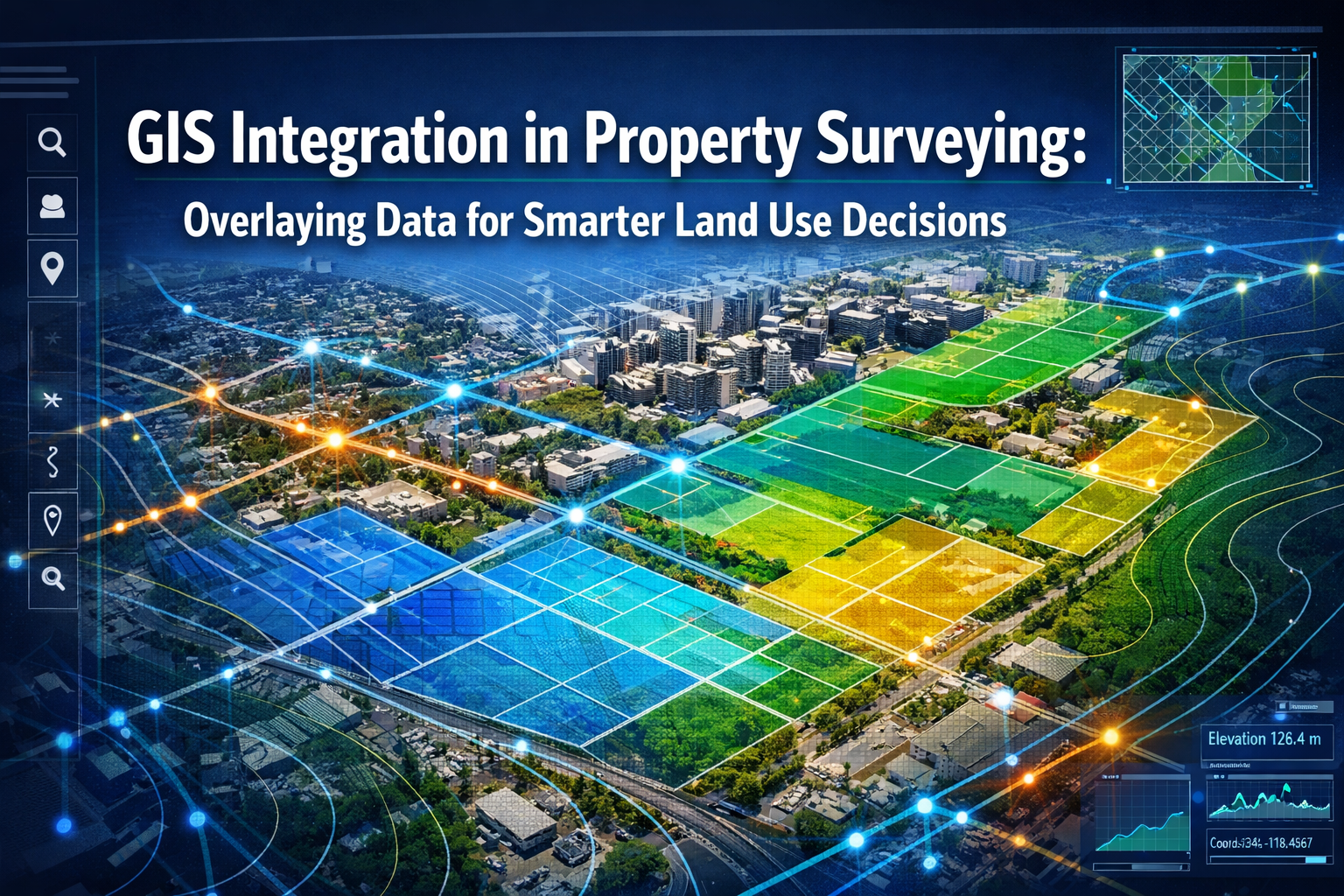
Modern property surveying has evolved far beyond measuring boundaries with chains and theodolites. Today's surveyors harness the power of Geographic Information Systems (GIS) to transform raw spatial data into actionable intelligence that shapes how communities grow, develop, and thrive. GIS integration in property surveying: overlaying data for smarter land use decisions represents a fundamental shift in how professionals analyze land, assess development potential, and support critical planning decisions that affect millions of people.
Imagine viewing a property not just as a flat boundary on paper, but as a rich, multi-dimensional landscape where zoning regulations, utility infrastructure, environmental constraints, topographic features, and demographic patterns all intersect in a visual tapestry of information. This is the promise that GIS integration delivers to property surveyors, planners, developers, and decision-makers in 2026.
Key Takeaways
- GIS integration enables multi-layer data visualization that combines property boundaries, zoning classifications, utility networks, environmental constraints, and topographic information into comprehensive analytical frameworks for informed land use planning
- Pattern recognition and spatial analysis through GIS overlays reveal development opportunities, infrastructure gaps, environmental risks, and regulatory conflicts that traditional surveying methods cannot easily identify
- Real-time collaborative platforms and digital twins are transforming surveying deliverables from static documents into interactive, continuously-updating decision-support tools for urban development and environmental assessments
- Technological advances including AI, autonomous drones, and cloud-based systems are accelerating GIS adoption across the surveying profession, with the global surveying market projected to reach $39.1 billion by 2026[2]
- Integration with Building Information Modeling (BIM) and enhanced GNSS precision standards are creating seamless workflows between surveying, design, and construction phases of development projects
Understanding GIS Integration in Modern Property Surveying
What Is GIS Integration in Property Surveying?
Geographic Information Systems represent sophisticated software platforms that capture, store, analyze, and visualize spatial data—information tied to specific geographic locations. When integrated into property surveying workflows, GIS transforms traditional survey measurements into dynamic, queryable databases that reveal relationships between different types of spatial information.
GIS integration in property surveying involves several core components:
- 📍 Georeferencing survey data to precise coordinate systems
- 🗺️ Creating digital layers for different data categories (boundaries, utilities, zoning, etc.)
- 🔄 Overlaying multiple datasets to identify patterns and relationships
- 📊 Performing spatial analysis to answer location-based questions
- 📱 Sharing interactive visualizations with stakeholders and decision-makers
The modernized National Spatial Reference System (NSRS), with core elements released for beta testing in June 2025, now provides more accurate and consistent geospatial data bases through geometric reference frames and gravimetric-derived geopotential datums[3][7]. This advancement enables greater interoperability across GIS workflows and surveying applications, ensuring that data from different sources aligns precisely.
The Evolution from Traditional to GIS-Enabled Surveying
Traditional property surveying focused primarily on establishing accurate measurements of property boundaries, elevations, and physical features. Surveyors would collect field data, process it manually or with basic software, and deliver static plans and reports to clients.
The integration of GIS has fundamentally expanded this scope:
| Traditional Surveying | GIS-Integrated Surveying |
|---|---|
| Single-purpose measurements | Multi-dimensional spatial analysis |
| Static paper deliverables | Interactive digital platforms |
| Isolated data sets | Integrated information layers |
| Limited pattern recognition | Advanced spatial analytics |
| Sequential workflows | Collaborative real-time access |
| Periodic updates | Continuous data refreshing |
Modern surveyors now serve as spatial data specialists who not only measure land but also contextualize those measurements within broader frameworks of zoning regulations, infrastructure networks, environmental conditions, and development patterns. This evolution positions surveyors as essential contributors to commercial property development and urban planning initiatives.
Key Technologies Driving GIS Integration
Several technological advances are accelerating GIS adoption across the surveying profession in 2026:
🛰️ Enhanced GNSS Precision: Global Navigation Satellite System advances now provide centimeter-level accuracy with real-time data availability, enabling surveyors to deliver more reliable results and supporting georeferencing applications[1][2]. This precision forms the foundation for accurate GIS data layers.
🚁 Multi-Sensor Autonomous Drones: Modern UAV systems carry synchronized sensor arrays combining LiDAR, photogrammetry cameras, multispectral sensors, and thermal imaging units. Data collection that previously required multiple site visits can now be completed in single flights with autonomous flight path planning and real-time sensor adjustment[1].
🤖 AI-Embedded Workflows: Artificial intelligence has moved beyond conceptual stages into core surveying operations. AI systems now automatically classify terrain, identify markers, flag anomalies, and generate preliminary surface models from raw field data—reducing manual processing time significantly[1].
☁️ Cloud-Based Platforms: Cloud infrastructure enables instant file sharing, browser-based 3D visualization, real-time revision syncing, and integrated communication between surveyors, engineers, and architects—replacing static document deliverables with interactive, collaborative workflows[1].
These technologies work synergistically with GIS platforms to create comprehensive spatial intelligence systems that support sophisticated land use analysis and decision-making.
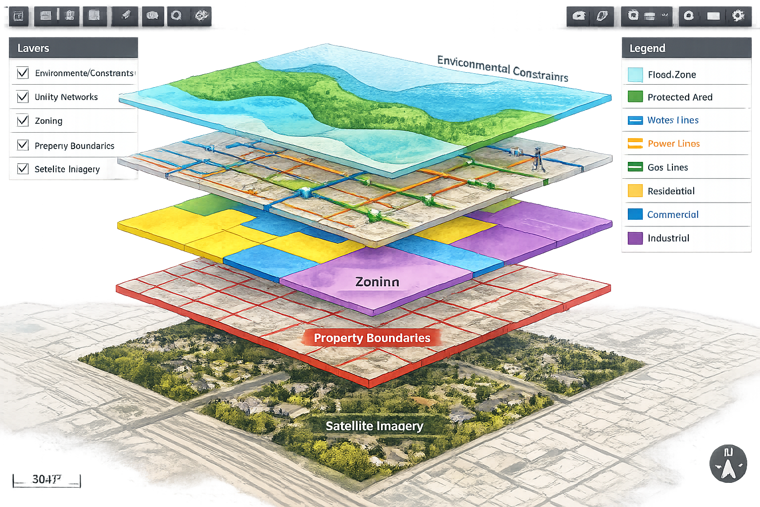
The Power of Data Overlay: Layering Information for Comprehensive Analysis
Understanding GIS Data Layers
The fundamental strength of GIS integration in property surveying lies in its ability to organize different types of spatial information into discrete data layers that can be viewed individually or in combination. Each layer represents a specific category of information, all georeferenced to the same coordinate system.
Common GIS layers used in property surveying include:
📐 Base Survey Layers:
- Property boundaries and cadastral parcels
- Topographic contours and elevation models
- Building footprints and structures
- Monuments and control points
- Easements and rights-of-way
🏛️ Regulatory and Planning Layers:
- Zoning classifications and districts
- Land use designations
- Setback requirements and building envelopes
- Historic preservation districts
- Overlay zones and special regulations
🔧 Infrastructure and Utility Layers:
- Water distribution networks
- Sanitary and storm sewer systems
- Electrical transmission lines
- Gas pipelines
- Telecommunications infrastructure
- Transportation networks
🌳 Environmental and Natural Resource Layers:
- Wetlands and water bodies
- Floodplains and flood zones
- Soil types and classifications
- Vegetation and tree canopy
- Protected habitats and conservation areas
- Slope analysis and erosion risk
📊 Demographic and Socioeconomic Layers:
- Population density patterns
- Income and property value distributions
- Land ownership information
- Development trends and growth patterns
When conducting boundary surveys or comprehensive structural surveys, surveyors can overlay these layers to provide clients with contextual understanding that extends far beyond simple property lines.
Pattern Recognition Through Multi-Layer Analysis
The true power of GIS integration emerges when multiple data layers are overlaid and analyzed together. This spatial analysis reveals patterns, relationships, and insights that remain invisible when examining individual datasets in isolation.
Identifying Development Opportunities:
By overlaying zoning classifications, existing infrastructure capacity, environmental constraints, and property ownership patterns, surveyors and planners can identify parcels that offer optimal development potential. For example, a GIS analysis might reveal:
- Commercially-zoned parcels with existing utility connections
- Underutilized properties in high-growth corridors
- Consolidation opportunities where adjacent parcels share ownership
- Areas where zoning changes could unlock development value
Detecting Infrastructure Gaps and Conflicts:
Overlaying utility network layers with proposed development sites reveals critical infrastructure considerations:
- ⚡ Electrical capacity limitations in specific areas
- 💧 Water pressure zones and service adequacy
- 🚰 Sewer capacity constraints
- 🛣️ Traffic impact and access challenges
This analysis supports more accurate project management and helps development teams anticipate infrastructure investment requirements before committing to projects.
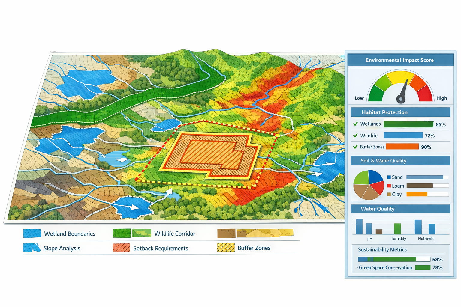
Assessing Environmental Compliance:
Environmental regulations increasingly shape land use decisions. GIS overlay analysis combining wetland boundaries, buffer zones, protected species habitats, and floodplain designations helps surveyors and developers:
- Identify buildable areas within constrained sites
- Calculate required setbacks and buffer distances
- Assess environmental impact mitigation requirements
- Support regulatory approval processes
Land surveyors are playing increasingly crucial roles in assessing and mitigating environmental impacts, with growing emphasis on sustainability and using surveying data to support responsible land development[1].
Creating Visual Decision-Support Tools
GIS integration transforms surveying deliverables from technical documents into visual decision-support tools that non-technical stakeholders can readily understand and use.
Interactive Maps and Dashboards:
Modern GIS platforms enable surveyors to create interactive web maps where users can:
- Toggle different data layers on and off
- Query specific features for detailed information
- Measure distances and calculate areas
- Compare scenarios and alternatives
- Export customized views and reports
3D Visualization and Digital Twins:
Real-time 3D digital twins now enable visualization of land behavior under various conditions, including slope erosion projections, water flow simulations, vegetation pattern changes, and infrastructure stress testing—deliverables increasingly provided by surveying firms for commercial development clients[1].
These visualizations help stakeholders understand complex spatial relationships and make more informed decisions about land use, design, and development strategies.
Applications in Urban Development and Environmental Assessments
GIS Integration for Urban Planning and Development
Urban development projects benefit immensely from GIS integration in property surveying, where multiple competing interests, regulatory requirements, and infrastructure considerations must be balanced.
Site Selection and Feasibility Analysis:
When developers seek optimal locations for new projects, GIS overlay analysis provides comprehensive feasibility assessment by combining:
- Zoning compatibility analysis showing permitted uses and density allowances
- Infrastructure accessibility mapping proximity to utilities, transportation, and services
- Market analysis incorporating demographic data and competitive property locations
- Regulatory constraints identifying historic districts, environmental limitations, and development restrictions
This integrated analysis significantly reduces project risk by identifying deal-breaking constraints early in the site selection process, before substantial investment occurs.
Master Planning and Community Development:
Municipal planners use GIS-integrated survey data to develop comprehensive plans that guide community growth:
🏘️ Residential Development Planning:
- Analyzing capacity for new housing units based on zoning and infrastructure
- Identifying areas suitable for different housing types and densities
- Planning school districts and community facilities based on population projections
- Assessing affordable housing distribution and equity considerations
🏢 Commercial and Mixed-Use Planning:
- Evaluating retail market gaps and opportunities
- Planning employment centers with adequate transportation access
- Designing mixed-use districts that integrate residential, commercial, and recreational uses
- Supporting commercial building surveys with comprehensive spatial context
Infrastructure Planning and Capital Improvement:
GIS overlay analysis supports strategic infrastructure investment by revealing:
- Areas experiencing growth that require utility capacity expansion
- Aging infrastructure requiring replacement or rehabilitation
- Optimal routing for new utility extensions
- Cost-effective phasing strategies for capital improvements
The global surveying and mapping services market's growth to $39.1 billion by 2026 reflects increasing recognition of these capabilities' value[2].
Environmental Assessment and Resource Management
Environmental considerations increasingly drive land use decisions, and GIS integration provides essential tools for comprehensive environmental assessment.
Wetland Delineation and Buffer Analysis:
Surveyors conducting wetland surveys can integrate their field observations with:
- Historical wetland inventory data
- Soil type classifications
- Hydrology and drainage patterns
- Regulatory buffer requirements
GIS overlay analysis precisely calculates buildable areas after applying required setbacks, helping developers understand site capacity while ensuring environmental compliance.
Floodplain Management and Stormwater Planning:
Overlaying topographic survey data with FEMA floodplain designations, watershed boundaries, and soil permeability classifications enables:
- Accurate flood risk assessment for specific parcels
- Stormwater management planning that accounts for drainage patterns
- Low-impact development design that preserves natural hydrology
- Climate change resilience planning incorporating sea-level rise projections
Habitat Conservation and Biodiversity Protection:
GIS integration supports environmental protection by:
- Mapping protected species habitats and migration corridors
- Identifying ecologically sensitive areas requiring preservation
- Designing development layouts that minimize habitat fragmentation
- Creating conservation easements and green infrastructure networks
Environmental and regulatory compliance focus continues to intensify, with land surveyors playing crucial roles in supporting responsible land development and resource management in response to stringent environmental regulations[1].
Sustainability and Green Infrastructure Planning:
Modern GIS analysis extends beyond regulatory compliance to support proactive sustainability initiatives:
- 🌳 Urban tree canopy analysis and expansion planning
- ☀️ Solar potential assessment based on building orientation and shading
- 🚶 Walkability and active transportation network planning
- 🌡️ Urban heat island identification and mitigation strategies
These applications demonstrate how GIS integration in property surveying supports not just development, but sustainable, resilient community building.
Case Study Applications: Real-World Impact
Urban Infill Development Project:
A developer seeking to build mixed-use development on an underutilized urban parcel engaged surveyors who used GIS integration to overlay:
- Current zoning (commercial) and proposed rezoning (mixed-use)
- Existing utility infrastructure and available capacity
- Historic building inventory (adjacent historic district)
- Transportation access and parking requirements
- Environmental constraints (none identified)
The analysis revealed that while the site had excellent infrastructure access and zoning compatibility, height restrictions related to the adjacent historic district would limit development density. This insight allowed the design team to optimize the project before investing in detailed architectural plans, saving significant time and resources.
Regional Environmental Corridor Planning:
A county planning department used GIS-integrated survey data to identify and protect environmental corridors connecting fragmented natural areas. The analysis overlaid:
- Existing protected lands and conservation easements
- Stream and wetland systems
- Wildlife habitat assessments
- Topographic features (ridgelines, steep slopes)
- Current land use and ownership patterns
The resulting corridor plan identified strategic parcels for conservation acquisition, guided local zoning decisions, and created a framework for regional habitat connectivity—demonstrating GIS integration's power for landscape-scale environmental planning.
Advanced GIS Techniques and Future Trends in Property Surveying

Spatial Analysis and Predictive Modeling
Beyond simple data overlay, advanced GIS techniques enable sophisticated spatial analysis and predictive modeling that forecast future conditions and support proactive planning.
Suitability Analysis:
GIS suitability modeling evaluates locations based on multiple weighted criteria to identify optimal sites for specific uses. For example, analyzing suitable locations for new schools might consider:
- Proximity to residential neighborhoods (high weight)
- Distance from existing schools (medium weight)
- Parcel size and availability (high weight)
- Transportation access (medium weight)
- Environmental constraints (high weight)
The GIS system combines these factors using weighted overlay techniques to generate suitability scores for every location in the study area, visually highlighting the most promising sites.
Network Analysis:
GIS network analysis tools evaluate connectivity and accessibility:
- Calculating optimal routes for utility infrastructure
- Analyzing service areas and coverage gaps
- Assessing emergency response times
- Evaluating transportation accessibility for development sites
Change Detection and Trend Analysis:
By comparing GIS layers from different time periods, surveyors can identify and quantify land use changes:
- Urban growth patterns and sprawl trends
- Vegetation loss or restoration
- Infrastructure expansion
- Property value appreciation patterns
This temporal analysis supports growth management planning and helps communities anticipate future infrastructure needs.
Integration with Building Information Modeling (BIM)
Land surveyors are increasingly collaborating with architects, engineers, and construction professionals to integrate geospatial data into Building Information Modeling (BIM) systems, enhancing project planning, reducing conflicts, and improving construction project efficiency[1].
Survey-to-BIM Workflows:
Modern workflows enable seamless transfer of survey data into BIM environments:
- Field data collection using total stations, GNSS receivers, and laser scanners
- Point cloud processing creating detailed 3D representations of existing conditions
- GIS integration adding contextual spatial data layers
- BIM model development incorporating survey data as the foundation
- Clash detection identifying conflicts between proposed design and existing conditions
This integration ensures that building designs account for actual site conditions, utility locations, and regulatory constraints from the earliest design stages.
Site Planning and Civil Design:
GIS-BIM integration particularly benefits civil engineering and site development:
- Accurate earthwork calculations based on existing topography
- Utility routing that avoids conflicts with existing infrastructure
- Grading plans that account for drainage patterns and environmental constraints
- Construction sequencing that reflects site access and staging requirements
For projects requiring structural engineering expertise, this integration ensures that foundation design accounts for precise soil conditions and subsurface features identified through GIS analysis.
Emerging Technologies Reshaping GIS Integration
Artificial Intelligence and Machine Learning:
AI systems are transforming GIS workflows in property surveying:
- Automated feature extraction identifying buildings, roads, vegetation, and other features from aerial imagery
- Predictive analytics forecasting development patterns, property values, and infrastructure needs
- Anomaly detection flagging data inconsistencies and potential errors
- Classification automation categorizing land use types and zoning compliance
These capabilities reduce manual processing time and enable surveyors to focus on analysis and interpretation rather than data preparation[1].
Real-Time Data Integration:
Cloud-based collaborative platforms now enable instant file sharing, browser-based 3D visualization, real-time revision syncing, and integrated communication between surveyors, engineers, and architects[1]. This real-time capability transforms project workflows:
- Field crews upload survey data directly to cloud platforms
- Office staff process and integrate data into GIS immediately
- Stakeholders access current information through web browsers
- Design teams incorporate updated survey data without delay
Mobile GIS and Field Data Collection:
Mobile GIS applications running on tablets and smartphones enable field surveyors to:
- View existing GIS data layers while conducting fieldwork
- Collect new data directly into GIS databases
- Verify information and resolve discrepancies on-site
- Share observations and photos with project teams instantly
This mobile capability bridges the traditional gap between field data collection and office-based analysis, creating more efficient and accurate workflows.
Digital Twin Technology:
Interactive, continuously-updating 3D digital models enable visualization of land behavior under various conditions, including slope erosion projections, water flow simulations, vegetation pattern changes, and infrastructure stress testing[1]. Digital twins represent the convergence of GIS, BIM, IoT sensors, and real-time data feeds to create living models of the built and natural environment.
For property surveying, digital twins offer:
- Continuous monitoring of site conditions and changes
- Scenario testing for proposed developments
- Infrastructure performance tracking
- Predictive maintenance planning
- Stakeholder engagement through immersive visualization
Market Growth and Industry Adoption
The global surveying and mapping services market demonstrates strong growth trajectory, projected to reach $39.1 billion by 2026, representing a 3.4% compound annual growth rate (CAGR), with the U.S. market estimated at $7.9 billion as of 2021[2].
Sector-Specific Growth Patterns:
Different surveying specializations show varying growth rates:
- Hydrographic surveying projected to reach $14.5 billion by 2026, growing at 3% CAGR[2]
- Cadastral surveying currently representing 29.6% of the global market with 3.3% revised CAGR[2]
- Aerial and drone surveying experiencing rapid adoption driven by UAV technology advances
- Geodetic surveying benefiting from enhanced GNSS precision standards
Technology Investment Trends:
Investments in drones, UAVs, 3D laser scanning, and cloud technologies are rising significantly as land surveying services adopt these tools to support growing demand for aerial surveying, cartographic surveying, and geodetic surveying services[2].
This investment reflects recognition that GIS integration and associated technologies represent not just operational improvements but fundamental competitive advantages in the modern surveying marketplace.
Implementing GIS Integration: Practical Considerations for Surveying Firms
Building GIS Capabilities
For surveying firms seeking to implement or enhance GIS integration, several practical considerations shape successful adoption.
Software Platform Selection:
Choosing appropriate GIS software depends on:
- Scale of operations (individual projects vs. enterprise-wide systems)
- Budget constraints (commercial platforms vs. open-source alternatives)
- Integration requirements (compatibility with existing CAD and surveying software)
- User expertise (learning curve and training requirements)
- Cloud vs. desktop deployment preferences
Popular GIS platforms for surveying applications include Esri ArcGIS, QGIS (open-source), Autodesk Civil 3D with GIS extensions, and specialized surveying software with integrated GIS capabilities[6].
Data Management and Quality Control:
Effective GIS integration requires robust data management practices:
- 📋 Standardized data schemas ensuring consistency across projects
- ✅ Quality control procedures verifying accuracy and completeness
- 🔄 Version control systems tracking data changes and updates
- 🔒 Data security protocols protecting sensitive client information
- 📚 Metadata documentation describing data sources, accuracy, and currency
Staff Training and Skill Development:
GIS integration requires surveyors to expand their skill sets beyond traditional surveying:
- Spatial analysis techniques and methodologies
- Database management and query languages
- Cartographic design and visualization principles
- Web mapping and application development
- Integration workflows between surveying and GIS software
Progressive firms invest in ongoing training to ensure staff can leverage GIS capabilities effectively.
Data Sources and Acquisition Strategies
Successful GIS integration depends on accessing relevant, accurate spatial data from various sources.
Public Data Sources:
Government agencies provide extensive spatial data that supports property surveying:
- Cadastral and parcel data from county assessors and recorders
- Zoning and land use information from planning departments
- Infrastructure data from utility departments and public works agencies
- Environmental data from EPA, USGS, NOAA, and state environmental agencies
- Demographic data from census bureaus and regional planning organizations
Many of these datasets are freely available through open data portals, though quality and currency vary significantly.
Commercial Data Providers:
Specialized data vendors offer value-added datasets:
- Enhanced parcel data with ownership and valuation information
- High-resolution aerial imagery and elevation models
- Utility infrastructure databases
- Market and demographic analytics
- Environmental risk assessments
Field Data Collection:
Surveyors generate primary spatial data through field work:
- Boundary surveys establishing precise property lines
- Topographic surveys capturing terrain features
- Utility locating identifying subsurface infrastructure
- Environmental assessments documenting site conditions
This field-collected data, when integrated into GIS platforms, becomes valuable baseline information for ongoing analysis and planning. Firms conducting homebuyer surveys can enhance their deliverables by incorporating relevant GIS layers that provide property context.
Delivering Value to Clients Through GIS Integration
The ultimate measure of successful GIS integration is enhanced value delivery to clients.
Enhanced Survey Deliverables:
Modern clients increasingly expect more than traditional survey plats:
- Interactive web maps allowing clients to explore survey results and contextual information
- 3D visualizations helping clients understand topographic conditions and spatial relationships
- Analytical reports quantifying development capacity, constraints, and opportunities
- Scenario comparisons illustrating alternatives and trade-offs
Expanded Service Offerings:
GIS capabilities enable surveyors to offer additional services:
- Site selection and feasibility studies
- Master planning and land use analysis
- Infrastructure capacity assessments
- Environmental compliance documentation
- Expert witness services with visual evidence presentation
These expanded offerings position surveyors as strategic advisors rather than mere data collectors, commanding higher fees and building stronger client relationships.
Faster Turnaround and Efficiency Gains:
GIS integration streamlines workflows and reduces project timelines:
- Automated data processing reducing manual drafting time
- Cloud collaboration enabling parallel work by distributed teams
- Reusable data layers eliminating redundant data collection
- Quality control tools catching errors before delivery
Remote surveying capabilities expansion continues enabling remote assessment and data collection, reducing on-site visit requirements, improving efficiency, and addressing safety concerns[1].
Challenges and Solutions in GIS Integration
Technical Challenges
Data Compatibility and Integration:
Integrating data from multiple sources with different formats, coordinate systems, and accuracy standards presents ongoing challenges. Solutions include:
- Establishing standardized data transformation workflows
- Implementing coordinate system conversion protocols
- Developing quality assessment procedures for external data
- Creating data validation routines before integration
System Performance and Scalability:
Large GIS datasets can strain system performance, particularly when working with high-resolution imagery, LiDAR point clouds, or complex 3D models. Addressing performance issues requires:
- Hardware upgrades (processing power, memory, storage)
- Database optimization and indexing
- Level-of-detail rendering for large datasets
- Cloud computing resources for intensive processing
Software Interoperability:
Surveying firms typically use multiple software platforms (CAD, surveying-specific software, GIS, BIM) that must exchange data seamlessly. Improving interoperability involves:
- Adopting industry-standard file formats
- Implementing middleware or integration tools
- Developing custom scripts and automation
- Selecting software with robust import/export capabilities
Organizational and Workflow Challenges
Cultural Resistance to Change:
Experienced surveyors may resist adopting GIS workflows that differ from established practices. Overcoming resistance requires:
- Demonstrating clear value and efficiency gains
- Providing comprehensive training and support
- Implementing gradual adoption rather than abrupt transitions
- Celebrating early successes and sharing best practices
Cost and Resource Constraints:
GIS implementation requires investment in software, hardware, training, and data acquisition. Managing costs involves:
- Phased implementation starting with core capabilities
- Leveraging open-source software where appropriate
- Utilizing free public data sources
- Calculating return on investment through efficiency gains and expanded services
Quality Control and Liability:
Integrating data from external sources raises questions about accuracy, currency, and professional liability. Managing these risks requires:
- Documenting data sources and known limitations
- Implementing verification procedures for critical data
- Maintaining professional liability insurance coverage
- Including appropriate disclaimers in deliverables
Data Privacy and Security Considerations
GIS integration often involves sensitive information about property ownership, infrastructure locations, and development plans. Protecting this information requires:
- 🔐 Access controls limiting data access to authorized personnel
- 🛡️ Encryption protecting data in transit and at storage
- 📝 Data use agreements defining permitted uses and sharing restrictions
- 🗑️ Data retention policies ensuring appropriate disposal of sensitive information
Firms conducting commercial valuations must be particularly attentive to data security given the sensitive financial information often involved.
Conclusion: Embracing the Future of Property Surveying
GIS integration in property surveying: overlaying data for smarter land use decisions represents far more than a technological upgrade—it embodies a fundamental transformation in how surveyors understand, analyze, and communicate spatial information. By layering zoning classifications, utility infrastructure, environmental constraints, topographic features, and demographic patterns into comprehensive analytical frameworks, modern surveyors provide decision-makers with unprecedented insight into land development opportunities and challenges.
The applications in urban development and environmental assessments demonstrate GIS integration's practical value. From identifying optimal development sites through multi-criteria suitability analysis to protecting sensitive environmental corridors through habitat connectivity planning, GIS-enabled surveying supports both economic development and environmental stewardship.
The technological trajectory is clear: artificial intelligence, autonomous drone systems, real-time digital twins, cloud collaboration platforms, and enhanced GNSS precision are accelerating GIS adoption across the surveying profession[1][2]. The global market growth to $39.1 billion by 2026 reflects increasing recognition that spatial intelligence drives better decisions[2].
Actionable Next Steps for Surveying Professionals
For Individual Surveyors:
✅ Develop GIS skills through online courses, professional certifications, or formal education programs focusing on spatial analysis and GIS software proficiency
✅ Experiment with open-source GIS platforms like QGIS to build familiarity without significant software investment
✅ Identify integration opportunities in current projects where GIS overlay analysis could provide additional client value
✅ Join professional networks and attend conferences focused on GIS in surveying to learn from peers and stay current with emerging practices
For Surveying Firms:
✅ Assess current capabilities and identify gaps between existing workflows and GIS-integrated best practices
✅ Develop implementation roadmap with phased adoption plan, budget allocation, and success metrics
✅ Invest in training to build organizational GIS expertise across technical staff
✅ Establish data partnerships with government agencies, utilities, and data providers to access relevant spatial information
✅ Market enhanced capabilities to existing and prospective clients, emphasizing value-added services enabled by GIS integration
For Clients and Decision-Makers:
✅ Request GIS-integrated deliverables when engaging surveying services, specifying desired data layers and analytical outputs
✅ Invest in spatial data infrastructure at organizational or municipal level to support ongoing planning and decision-making
✅ Engage surveyors early in development and planning processes to leverage their spatial analysis capabilities for site selection and feasibility assessment
✅ Explore collaborative platforms that enable real-time access to survey data and GIS analysis throughout project lifecycles
The future of property surveying lies not in simply measuring land, but in understanding land through the rich, multi-dimensional lens that GIS integration provides. As zoning regulations grow more complex, infrastructure systems age and require strategic investment, environmental constraints intensify, and communities seek sustainable development patterns, the ability to overlay diverse spatial data and extract actionable insights becomes increasingly valuable.
Surveyors who embrace GIS integration position themselves not as technical service providers, but as strategic spatial intelligence advisors—essential partners in shaping how communities grow, develop, and thrive. The tools, technologies, and techniques exist today to transform property surveying practice. The question is not whether to adopt GIS integration, but how quickly to implement it to remain competitive and relevant in an increasingly data-driven built environment.
Whether conducting RICS commercial building surveys or residential property assessments, the integration of GIS capabilities elevates the surveying profession from measurement to meaning—from data collection to decision support—from documenting what exists to envisioning what's possible.
References
[1] Future Land Surveying 2026 – https://haller-blanchard.com/future-land-surveying-2026/
[2] Global Surveying And Mapping Services Industry To 2026 Inclination Towards Gis Presents Opportunities For Gnss Researchandmarkets – https://www.businesswire.com/news/home/20220615005595/en/Global-Surveying-and-Mapping-Services-Industry-to-2026—Inclination-towards-GIS-Presents-Opportunities-for-GNSS—ResearchAndMarkets.com
[3] Watch – https://www.youtube.com/watch?v=PHn-r7QGMOI
[4] Property Data Pulse – https://giswebtech.com/property-data-pulse
[5] Mapping The Districts Future Cartography – https://www.swf.usace.army.mil/Media/News-Stories/Article/4405309/mapping-the-districts-future-cartography/
[6] Carlson Gis – https://carlsonps.com/products/carlson-gis
[7] A New Years Resolution For National Spatial Reference System Users – https://www.gpsworld.com/a-new-years-resolution-for-national-spatial-reference-system-users/
[8] Gis News – https://www.gissurveyors.com/category/gis-news/