Picture a surveyor standing at a property line, armed not just with traditional equipment but with a powerful digital platform that instantly reveals every critical detail about the land beneath their feet. Property boundaries, zoning restrictions, underground utilities, environmental constraints, and historical land use patterns—all visible on a single interactive map. This is the transformative power of GIS Integration in Property Surveying: Overlaying Boundaries, Zoning, and Utilities for Smarter Decisions in 2026.
Geographic Information Systems (GIS) have evolved from specialized mapping tools into central integration hubs that revolutionize how surveyors, planners, and developers make decisions. By combining multiple datasets into unified visual platforms, GIS technology enables professionals to identify patterns, assess compliance, and predict challenges before they become costly problems. The integration of boundaries, zoning regulations, and utility infrastructure creates a comprehensive spatial intelligence framework that drives smarter, faster, and more accurate decision-making across the property development lifecycle.
Key Takeaways
- GIS serves as a central integration hub that combines property boundaries, zoning information, and utility locations into single interactive maps, enabling surveyors to analyze multiple datasets simultaneously and identify critical spatial relationships[2]
- Location-based compliance frameworks link zoning regulations, land use restrictions, permits, inspections, and violations directly to geographic locations, helping jurisdictions prioritize inspections and support rezoning decisions with spatial evidence[5]
- AI-driven pattern recognition integrated with GIS workflows processes massive geospatial datasets rapidly, identifying trends in land use, detecting terrain changes over time, and enabling predictive analysis for strategic planning[2]
- Cloud-based collaborative platforms enable real-time file sharing, 3D visualization, and synchronized communication between surveyors, engineers, architects, and stakeholders, reducing project timelines and minimizing conflicts[1]
- BIM-GIS convergence creates digital twins that integrate geospatial data with building models, enabling visualization of land behavior under various conditions and infrastructure stress testing before construction begins[1]
Understanding GIS as the Central Integration Hub for Property Surveying

Geographic Information Systems have fundamentally transformed from simple mapping software into sophisticated data integration platforms that serve as the backbone of modern property surveying operations. In 2026, GIS technology functions as the central nervous system for spatial data management, enabling surveyors to overlay multiple critical datasets and extract actionable insights that were previously impossible to obtain.
The Foundation of Multi-Layer Data Integration
At its core, GIS integration in property surveying revolves around the ability to combine disparate datasets into cohesive spatial representations. Geographic Information Systems now serve as the primary platform for overlaying multiple datasets, enabling surveyors to combine zoning information, property boundaries, and utility locations in a single interactive map[2]. This integration creates a comprehensive view of property characteristics that extends far beyond traditional survey deliverables.
The power of this approach lies in its layered architecture. Each dataset—whether property boundaries, zoning classifications, utility networks, topographic features, or environmental constraints—exists as a separate layer that can be toggled on or off, analyzed independently, or combined with other layers to reveal spatial relationships. This flexibility allows surveyors to customize their analysis based on specific project requirements while maintaining access to the complete dataset.
Enhanced Data Management and Pattern Recognition
GIS provides better data organization and centralization of vast amounts of geospatial data, allowing surveyors to identify patterns and trends in land use to make more informed decisions[2]. This capability represents a quantum leap from traditional surveying methods that relied on isolated data points and manual analysis.
Pattern recognition capabilities enable surveyors to:
- 📊 Identify recurring land use trends across multiple properties
- 🔍 Detect anomalies in boundary configurations that may indicate disputes
- 📈 Analyze historical development patterns to predict future growth
- 🗺️ Recognize spatial correlations between zoning changes and property values
- ⚠️ Flag potential conflicts between proposed developments and existing infrastructure
When conducting boundary surveys, professionals can now overlay historical property records with current GPS measurements, utility easements, and zoning restrictions to create comprehensive boundary analysis reports that address multiple stakeholder concerns simultaneously.
Real-Time Data Accuracy and GNSS Integration
The implementation of Global Navigation Satellite System (GNSS) enhancements provides real-time data with centimeter-level accuracy, enabling surveyors to deliver more reliable results integrated into GIS frameworks[1]. This precision level, combined with GIS integration, creates a feedback loop where field measurements immediately populate central databases and become available for analysis and decision-making.
The National Spatial Reference System (NSRS) modernization initiative further enhances this capability. The National Geodetic Survey is modernizing the National Spatial Reference System with geometric reference frames and gravimetric-derived geopotential datums; core elements were released for beta testing in June 2025[3], providing a more accurate and consistent foundation for all geospatial data interoperability.
| Traditional Surveying | GIS-Integrated Surveying |
|---|---|
| Isolated data collection | Centralized data integration |
| Manual pattern analysis | Automated pattern recognition |
| Static paper deliverables | Dynamic interactive maps |
| Sequential data processing | Real-time data synchronization |
| Limited stakeholder access | Cloud-based collaborative access |
| Meter-level accuracy | Centimeter-level precision |
This technological evolution supports comprehensive property assessments, including structural surveys that benefit from integrated topographic and geotechnical data layers.
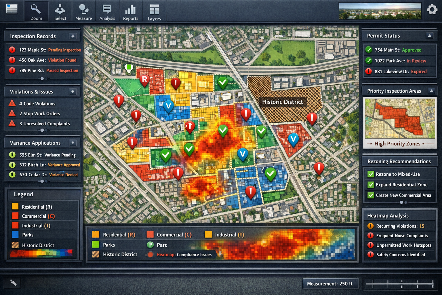
Location-Based Compliance Framework: Overlaying Boundaries, Zoning, and Utilities
The convergence of property boundaries, zoning regulations, and utility infrastructure within GIS platforms has created what industry professionals now call location-based compliance frameworks. These frameworks represent a paradigm shift in how regulatory compliance is assessed, monitored, and enforced across property development projects.
Creating Map-Centric Compliance Environments
ArcGIS implementations now create map-centric compliance environments that link zoning, land use, historic districts, permits, inspections, and violations directly to location[5]. This geographic approach to compliance management transforms abstract regulations into visually intuitive spatial constraints that all stakeholders can understand and navigate.
Key components of location-based compliance frameworks include:
- Zoning overlay layers that display permitted uses, density restrictions, setback requirements, and height limitations
- Property boundary datasets with ownership information, easements, and right-of-way designations
- Utility infrastructure networks showing water, sewer, gas, electric, and telecommunications lines
- Environmental constraint layers identifying wetlands, floodplains, protected habitats, and contaminated sites
- Historic district boundaries with associated preservation requirements and design guidelines
- Permit and inspection records linked to specific parcels and development phases
This comprehensive spatial framework enables surveyors conducting RICS commercial building surveys to immediately identify regulatory constraints that may impact property development potential or valuation.
Pattern Analysis for Strategic Planning and Enforcement
Pattern recognition for strategic planning helps jurisdictions identify where recurring issues occur, allowing staff to prioritize inspections and support boards with spatially framed evidence for rezonings and variances[5]. This analytical capability transforms reactive compliance enforcement into proactive strategic planning.
"GIS-powered pattern analysis enables municipalities to shift from responding to violations to preventing them through data-driven inspection prioritization and evidence-based policy development."
Surveyors can leverage these patterns to provide clients with predictive compliance assessments that identify potential regulatory challenges before they arise. For example, analyzing historical variance approval rates in specific zoning districts can inform development feasibility studies and risk assessments.
Utility Conflict Detection and Infrastructure Planning
One of the most critical applications of GIS integration involves utility overlay analysis. By combining property boundaries with comprehensive utility infrastructure datasets, surveyors can identify potential conflicts before excavation begins, dramatically reducing the risk of costly utility strikes and project delays.
Advanced GIS platforms now integrate:
- Subsurface utility engineering (SUE) data with precise horizontal and vertical positioning
- Utility ownership and maintenance responsibility information
- Capacity and condition assessments for existing infrastructure
- Planned infrastructure improvements and expansion projects
- Easement and right-of-way restrictions affecting property development
This integration proves invaluable for professionals conducting drainage surveys or assessing properties for development potential, as it reveals both existing infrastructure and available capacity for new connections.
Compliance Visualization for Stakeholder Communication
The visual nature of GIS-based compliance frameworks dramatically improves stakeholder communication and decision-making. Complex regulatory requirements that might require dozens of pages to explain in text can be communicated instantly through color-coded maps that show permissible uses, restricted areas, and development opportunities.
This visualization capability benefits:
- Property owners seeking to understand development potential
- Developers assessing feasibility and regulatory risk
- Municipal planners evaluating rezoning applications
- Legal professionals preparing variance requests or appeals
- Community members participating in public hearings
When combined with property certification processes, GIS-based compliance visualization creates transparent, defensible documentation of regulatory compliance throughout the development lifecycle.
AI-Driven Data Processing and Advanced Visualization for Smarter Decisions
The integration of artificial intelligence and advanced visualization technologies with GIS platforms represents the cutting edge of property surveying innovation in 2026. These technologies amplify the analytical power of GIS integration, enabling surveyors to process unprecedented volumes of data and communicate findings through immersive, interactive experiences.
Machine Learning Algorithms for Geospatial Analysis
Machine learning algorithms integrated with GIS workflows now process massive datasets rapidly, identifying patterns and detecting changes in terrain and structures over time[2]. This AI-driven approach automates tasks that previously required weeks of manual analysis, while simultaneously improving accuracy and consistency.
AI applications in GIS-integrated surveying include:
- Automated feature extraction from aerial imagery and LiDAR data
- Change detection algorithms that identify alterations in terrain, vegetation, or structures
- Predictive modeling for land use trends and development patterns
- Anomaly detection flagging potential boundary disputes or encroachments
- Classification algorithms categorizing land cover and land use from remote sensing data
- Natural language processing extracting relevant information from permit records and legal descriptions
These capabilities prove particularly valuable when conducting stock condition surveys across large property portfolios, where AI can identify maintenance patterns and predict future deterioration based on historical data.
Digital Twins and 3D Visualization Technologies
High-fidelity, interactive 3D models now integrate GIS data to enable visualization of land behavior under various conditions, including slope erosion projections, water flow simulations, and infrastructure stress testing[1]. These digital twin technologies create virtual replicas of physical environments that can be manipulated and analyzed without real-world consequences.
Digital twins built on GIS foundations enable surveyors to:
- Simulate development scenarios and visualize their impact on surrounding properties
- Model water drainage patterns under different rainfall scenarios
- Assess viewshed impacts of proposed structures
- Analyze shadow patterns throughout the year for solar access studies
- Test infrastructure capacity under various load scenarios
- Visualize underground utility networks in 3D space relative to proposed excavations
This technology bridges the gap between abstract data and tangible understanding, making it easier for non-technical stakeholders to grasp complex spatial relationships and make informed decisions.
BIM-GIS Convergence for Integrated Project Delivery
Land surveyors increasingly collaborate with architects, engineers, and construction professionals to integrate geospatial data and GIS information into Building Information Modeling (BIM) systems, enhancing project planning and reducing conflicts[1]. This BIM-GIS convergence creates seamless workflows where site conditions inform building design and building requirements influence site development.
The integration enables:
- Automated clash detection between proposed structures and existing site conditions
- Coordinated design development where changes to site grading automatically update building elevations
- Integrated quantity takeoffs combining earthwork volumes with material quantities
- Lifecycle asset management linking as-built building models with geospatial facility management systems
- Regulatory compliance verification ensuring designs meet setback, height, and coverage requirements
Professionals conducting Level 3 RICS building surveys can leverage BIM-GIS integration to provide clients with comprehensive assessments that combine building condition analysis with site constraint evaluation.
Cloud-Based Collaboration and Remote Assessment
Cloud-based collaborative workflows now utilize platforms that enable instant file sharing, 3D visualization in browsers, real-time revision syncing, and integrated communication between surveyors, engineers, and architects[1]. This infrastructure democratizes access to sophisticated GIS analysis tools and enables distributed teams to collaborate effectively regardless of geographic location.
Advanced GIS integration with drone and remote surveying technologies reduces the need for multiple site visits, with what previously required several visits now captured in single, highly detailed survey operations[1]. This efficiency gain translates directly to cost savings for clients while maintaining or improving data quality.
Cloud-based GIS platforms offer:
- 🌐 Browser-based access to GIS data and analysis tools
- 📱 Mobile field data collection with automatic synchronization
- 🔄 Version control and revision tracking for collaborative projects
- 💬 Integrated communication tools linking discussions to specific map locations
- 🔐 Role-based access control ensuring data security and privacy
- 📊 Automated reporting and dashboard generation
These capabilities support comprehensive property assessments, including schedule of condition reports that benefit from cloud-based photo documentation and collaborative annotation.
Environmental Impact Assessment and Sustainability Planning
GIS integration plays an increasingly crucial role in assessing and mitigating environmental impacts, with surveying data supporting responsible land development and resource management[1]. The ability to overlay environmental constraint layers with development proposals enables early identification of potential impacts and informed mitigation planning.
Environmental applications include:
- Wetland delineation and buffer zone analysis
- Floodplain mapping and flood risk assessment
- Habitat connectivity analysis for wildlife corridors
- Stormwater management modeling and green infrastructure planning
- Solar potential analysis for renewable energy development
- Carbon sequestration estimation for vegetation management
This environmental focus aligns with growing regulatory requirements and stakeholder expectations for sustainable development practices.
Practical Tools and Workflows for Surveyors in Development Planning
Understanding the theoretical benefits of GIS integration is only the first step. Successful implementation requires mastery of specific tools, workflows, and best practices that translate technological capability into practical value for clients and stakeholders.
Essential GIS Software Platforms for Property Surveyors
Several GIS software platforms have emerged as industry standards for property surveying applications, each offering distinct advantages for different use cases and organizational requirements.
Leading GIS platforms include:
- Esri ArcGIS: The most comprehensive GIS platform, offering advanced spatial analysis, 3D visualization, and extensive customization options through Python scripting and ArcGIS Pro
- QGIS: Open-source alternative providing robust functionality without licensing costs, ideal for smaller firms or specific project applications
- Trimble Business Center: Specialized surveying software with integrated GIS capabilities, optimized for processing field survey data
- Carlson GIS: Purpose-built for surveyors, offering seamless integration between CAD drafting and GIS analysis workflows[7]
- Autodesk Civil 3D: Engineering design platform with GIS integration capabilities for infrastructure projects
When selecting platforms, surveyors should consider factors including data compatibility, analysis capabilities, visualization options, cloud integration, mobile field collection support, and total cost of ownership.
Step-by-Step Workflow for Boundary-Zoning-Utility Overlay Analysis
Implementing GIS Integration in Property Surveying: Overlaying Boundaries, Zoning, and Utilities for Smarter Decisions requires systematic workflows that ensure data quality, analytical rigor, and actionable deliverables.
Recommended workflow:
-
Data Acquisition and Preparation
- Obtain property boundary data from field surveys, deed research, and recorded plats
- Acquire current zoning data from municipal GIS portals or planning departments
- Collect utility infrastructure data from utility companies and subsurface utility engineering
- Gather topographic data from LiDAR, photogrammetry, or traditional surveying
- Verify data accuracy, coordinate systems, and currency
-
Spatial Data Integration
- Import all datasets into GIS platform using appropriate coordinate reference systems
- Perform coordinate transformations to ensure spatial alignment
- Create standardized layer structure with consistent naming conventions
- Establish topology rules to identify and resolve spatial conflicts
- Document data sources, acquisition dates, and accuracy specifications
-
Overlay Analysis and Conflict Detection
- Activate relevant layers for specific analysis objectives
- Apply spatial queries to identify overlapping features and potential conflicts
- Generate buffer zones around utilities to assess clearance requirements
- Calculate setback compliance for property boundaries and zoning regulations
- Identify easements and right-of-way restrictions affecting development areas
-
Pattern Recognition and Trend Analysis
- Apply statistical analysis to identify land use patterns
- Generate heat maps showing development density and growth trends
- Analyze historical zoning changes and variance approval patterns
- Assess correlation between infrastructure capacity and development potential
- Create predictive models for future development scenarios
-
Visualization and Deliverable Generation
- Design clear, intuitive map layouts with appropriate symbology
- Generate 3D visualizations for complex spatial relationships
- Create interactive web maps for stakeholder collaboration
- Produce compliance reports with supporting spatial evidence
- Export data in formats compatible with client systems and workflows
This systematic approach ensures comprehensive analysis while maintaining data integrity and analytical transparency.
Mobile GIS for Field Data Collection
Modern GIS integration extends beyond desktop analysis to include mobile field data collection that streamlines workflows and improves data quality through real-time validation and synchronization.
Mobile GIS applications enable surveyors to:
- Collect GPS positions with centimeter-level accuracy using GNSS receivers
- Photograph features with automatic geotagging and attribute attachment
- Annotate maps with field observations and condition assessments
- Validate existing data against observed conditions
- Update databases in real-time through cellular or satellite connectivity
- Access reference data including utility records and historical surveys
This field-to-office integration eliminates redundant data entry, reduces transcription errors, and accelerates project delivery timelines.
Integration with Traditional Surveying Equipment
Successful GIS implementation doesn't require abandoning traditional surveying equipment. Instead, modern workflows integrate total stations, GPS receivers, and laser scanners with GIS platforms to create comprehensive data collection and analysis ecosystems.
Integration approaches include:
- Direct data download from survey instruments to GIS databases
- Automated coordinate transformation and quality control checking
- Integration of terrestrial laser scanning point clouds with GIS terrain models
- Combination of conventional survey measurements with GPS positions for optimal accuracy
- Synchronization of field notes and sketches with geospatial feature databases
This hybrid approach leverages the precision of traditional surveying methods while gaining the analytical power and visualization capabilities of GIS platforms.
Training and Professional Development Resources
Maximizing the value of GIS Integration in Property Surveying: Overlaying Boundaries, Zoning, and Utilities for Smarter Decisions requires ongoing professional development and skills enhancement.
Recommended resources include:
- Esri Training: Comprehensive courses covering ArcGIS fundamentals through advanced spatial analysis
- NSPS Webinars: National Society of Professional Surveyors offers GIS-focused continuing education
- University Certificate Programs: Many institutions offer GIS certificate programs tailored for surveying professionals
- Online Learning Platforms: LinkedIn Learning, Coursera, and Udemy provide flexible GIS training options
- Professional Conferences: Annual conferences offer workshops, technical sessions, and networking opportunities
Investment in GIS training pays dividends through improved efficiency, expanded service offerings, and enhanced competitive positioning.
Case Studies: Real-World Applications of GIS Integration
Examining practical applications demonstrates how GIS Integration in Property Surveying: Overlaying Boundaries, Zoning, and Utilities for Smarter Decisions translates into tangible benefits for clients and communities.
Municipal Planning Department Transformation
A mid-sized municipality implemented a comprehensive GIS-based planning system that integrated property boundaries, zoning regulations, utility infrastructure, and permit records into a unified platform. The results included:
- 75% reduction in time required to process development applications
- Significant decrease in utility conflicts during construction projects
- Enhanced public engagement through interactive web mapping portals
- Data-driven rezoning decisions supported by spatial pattern analysis
- Improved interdepartmental coordination between planning, utilities, and public works
This transformation demonstrates how GIS integration creates value across entire organizations, not just individual projects.
Large-Scale Infrastructure Development
A major transportation infrastructure project utilized GIS integration to coordinate surveys across multiple jurisdictions, property owners, and utility providers. The integrated approach enabled:
- Identification of optimal alignment corridors minimizing property impacts
- Early detection of utility conflicts requiring relocation or protection
- Streamlined right-of-way acquisition through comprehensive property analysis
- Environmental impact assessment integrating multiple constraint layers
- Stakeholder communication through 3D visualizations and interactive maps
The project completed environmental review six months ahead of schedule, with cost savings exceeding $2 million through early conflict resolution.
Commercial Property Due Diligence
A commercial real estate developer utilized GIS-integrated surveying for due diligence on a mixed-use development site. The analysis revealed:
- Zoning overlay restricting building heights in portions of the property
- Utility easement limiting building placement options
- Wetland buffer zone reducing developable area by 15%
- Historic district boundary requiring design review approval
- Planned road widening affecting site access configuration
This comprehensive analysis enabled the developer to renegotiate the purchase price and redesign the project to maximize value within identified constraints. Understanding these factors early in the process, similar to insights gained from Level 2 and Level 3 surveys, prevented costly surprises during later development phases.
Future Trends and Emerging Technologies
The evolution of GIS Integration in Property Surveying: Overlaying Boundaries, Zoning, and Utilities for Smarter Decisions continues to accelerate, with several emerging technologies poised to further transform the industry.
Artificial Intelligence and Automated Analysis
AI capabilities will expand beyond pattern recognition to include autonomous decision-making for routine surveying tasks, predictive analytics for property development potential, and natural language interfaces enabling non-technical users to perform sophisticated spatial queries.
Augmented Reality Field Applications
Augmented reality (AR) headsets and mobile devices will overlay GIS data onto real-world views, enabling surveyors to visualize underground utilities, property boundaries, and zoning restrictions directly in the field without referencing separate maps or documents.
Internet of Things (IoT) Integration
Smart sensors embedded in infrastructure will continuously update GIS databases with real-time condition data, creating dynamic maps that reflect current rather than historical conditions and enabling predictive maintenance planning.
Blockchain for Property Records
Blockchain technology may revolutionize property record management by creating immutable, transparent ownership records that integrate seamlessly with GIS platforms, reducing title disputes and streamlining transactions.
Quantum Computing for Complex Analysis
As quantum computing becomes accessible, it will enable unprecedented computational power for complex spatial analysis, simulation modeling, and optimization problems that currently require days or weeks to process.
Overcoming Implementation Challenges

Despite clear benefits, organizations face several challenges when implementing comprehensive GIS integration for property surveying.
Data Quality and Standardization
Inconsistent data formats, varying accuracy levels, and incomplete datasets represent significant obstacles. Solutions include:
- Establishing data quality standards and validation procedures
- Investing in data cleanup and standardization projects
- Implementing ongoing data maintenance protocols
- Creating metadata documentation for all datasets
- Developing partnerships with data providers for regular updates
Technology Investment and ROI
The initial cost of GIS software, hardware, and training can be substantial. Organizations should:
- Conduct thorough cost-benefit analysis including efficiency gains and risk reduction
- Consider phased implementation starting with high-value applications
- Explore cloud-based solutions reducing upfront infrastructure costs
- Quantify value through metrics including time savings, error reduction, and expanded services
- Investigate grant funding for technology modernization initiatives
Organizational Change Management
Successful GIS integration requires cultural change and workflow adaptation. Effective strategies include:
- Securing executive sponsorship and resource commitment
- Engaging end users in system design and implementation
- Providing comprehensive training and ongoing support
- Celebrating early wins and communicating success stories
- Establishing clear roles and responsibilities for data management
Interoperability and System Integration
Connecting GIS platforms with existing surveying software, CAD systems, and enterprise databases presents technical challenges. Approaches include:
- Selecting platforms with robust API and data exchange capabilities
- Utilizing industry-standard data formats (GeoJSON, Shapefile, GML)
- Implementing middleware solutions for system integration
- Developing custom scripts and automation tools
- Partnering with vendors offering integration support
Regulatory Considerations and Professional Standards
GIS Integration in Property Surveying: Overlaying Boundaries, Zoning, and Utilities for Smarter Decisions must comply with professional standards and regulatory requirements governing surveying practice.
Professional Licensing and Liability
Licensed surveyors remain professionally responsible for work products incorporating GIS analysis. Key considerations include:
- Ensuring GIS analysis complies with surveying standards of practice
- Maintaining professional liability insurance covering technology-enabled services
- Clearly documenting data sources, methodologies, and limitations
- Distinguishing between surveying services and planning or engineering analysis
- Obtaining appropriate professional licenses for expanded service offerings
Data Privacy and Security
GIS databases containing property information must protect privacy and confidentiality. Best practices include:
- Implementing role-based access controls limiting data exposure
- Encrypting sensitive data in transit and at rest
- Complying with data protection regulations (GDPR, CCPA)
- Establishing data retention and disposal policies
- Conducting regular security audits and vulnerability assessments
Accuracy Standards and Quality Assurance
GIS-integrated deliverables must meet accuracy requirements appropriate for their intended use. Quality assurance measures include:
- Documenting accuracy specifications for all datasets
- Performing independent verification of critical measurements
- Implementing automated quality control checks
- Maintaining audit trails for data modifications
- Providing clear accuracy statements in deliverables
Conclusion
GIS Integration in Property Surveying: Overlaying Boundaries, Zoning, and Utilities for Smarter Decisions represents far more than a technological upgrade—it fundamentally transforms how surveyors analyze spatial relationships, assess compliance, and communicate findings to stakeholders. By centralizing geospatial data into unified platforms that enable pattern recognition, predictive analysis, and immersive visualization, GIS integration empowers surveyors to deliver unprecedented value to clients navigating increasingly complex property development challenges.
The convergence of property boundaries, zoning regulations, and utility infrastructure within intelligent GIS frameworks creates location-based compliance environments that make regulatory requirements transparent and actionable. Combined with AI-driven data processing, cloud-based collaboration, and BIM integration, these systems enable surveyors to identify conflicts before they occur, optimize development designs, and support decision-making with compelling spatial evidence.
Actionable Next Steps
For surveying professionals seeking to harness the power of GIS integration:
- Assess current capabilities by inventorying existing data, software, and skills to identify gaps and opportunities
- Define strategic objectives focusing on high-value applications that address client needs and competitive differentiation
- Invest in foundational training through professional development programs covering GIS fundamentals and advanced spatial analysis
- Start with pilot projects demonstrating value through focused applications before enterprise-wide implementation
- Build data partnerships with municipalities, utilities, and other data providers to access comprehensive spatial datasets
- Establish quality standards ensuring GIS-integrated deliverables meet professional and regulatory requirements
- Communicate value effectively by showcasing GIS capabilities through case studies, visualizations, and client education
The future of property surveying lies not in choosing between traditional methods and GIS technology, but in strategically integrating both to create comprehensive analytical frameworks that serve clients more effectively. Organizations that embrace GIS Integration in Property Surveying: Overlaying Boundaries, Zoning, and Utilities for Smarter Decisions position themselves as essential partners in the development process, providing the spatial intelligence that transforms uncertainty into actionable insight.
Whether conducting boundary surveys, supporting structural engineering assessments, or providing expert witness services, GIS integration enhances every aspect of professional surveying practice. The technology exists, the methodologies are proven, and the competitive advantages are clear. The question is no longer whether to integrate GIS into surveying workflows, but how quickly organizations can implement these capabilities to serve clients and communities more effectively in 2026 and beyond.
References
[1] Future Land Surveying 2026 – https://haller-blanchard.com/future-land-surveying-2026/
[2] The Future Of Land Surveying Technology And Upcoming Trends In 2026 – https://metricop.com/blogs/land-surveying/the-future-of-land-surveying-technology-and-upcoming-trends-in-2026
[3] Watch – https://www.youtube.com/watch?v=PHn-r7QGMOI
[4] Survey Gis – https://www.dibblecorp.com/services/survey-gis/
[5] 5 Planning Trends 2026 – https://www.esri.com/en-us/industries/blog/articles/5-planning-trends-2026
[6] Property Data Pulse – https://giswebtech.com/property-data-pulse
[7] Carlson Gis – https://carlsonps.com/products/carlson-gis
[8] Arizona Land Use And Zoning 6 Development Predictions For 2026 – https://azbigmedia.com/real-estate/arizona-land-use-and-zoning-6-development-predictions-for-2026/
[9] Press Releases – https://www.gissurveyors.com/about/press-releases/
[10] Gis Surveying Guide – https://www.fveng.com/gis-surveying-guide/