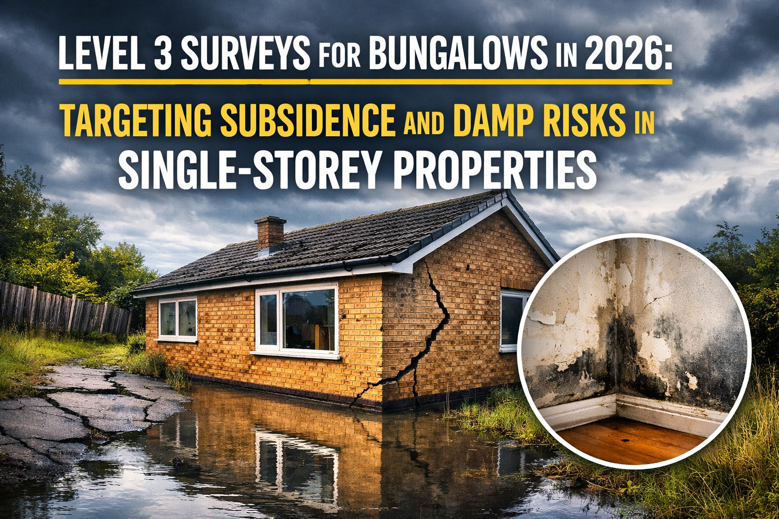
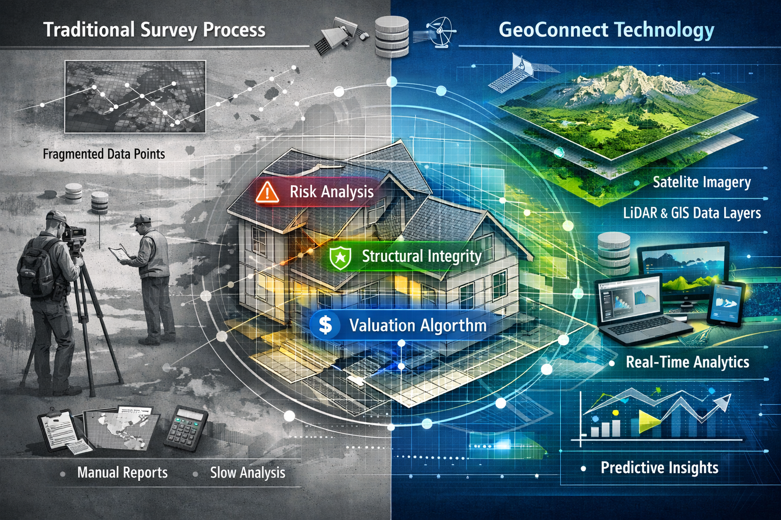
Property transaction delays cost the UK economy billions annually, with a staggering 67% of delays in 2026 stemming from incomplete upfront assessments.[4] This statistic reveals a fundamental weakness in traditional surveying workflows: the information needed to make informed valuation decisions arrives too late, or not at all. Enter GeoConnect—a data aggregation platform designed to consolidate property-specific information from multiple sources at the point of instruction, fundamentally changing how surveyors approach complex valuations. GeoConnect Tools for Upfront Valuation Insights: Reducing Delays in 2026 Building Surveys represents a strategic shift from reactive problem-solving to proactive risk assessment, particularly valuable when evaluating challenging properties like high-rise buildings or structures with complex histories.
The platform doesn't replace professional judgment; instead, it provides a stronger informational foundation that enables chartered surveyors to make educated decisions earlier in the process.[1] For professionals conducting RICS building surveys or Level 3 building surveys, this upfront intelligence can mean the difference between a smooth transaction and weeks of costly delays.

Key Takeaways
- GeoConnect consolidates multi-source property data at instruction stage, reducing information gaps that cause 67% of transaction delays in 2026
- Pre-survey risk assessment enables surveyors to identify complex issues (structural concerns, environmental factors, planning history) before site visits
- Streamlined workflows reduce unnecessary follow-up surveys and queries, cutting overall assessment timelines by significant margins
- Professional judgment remains central—GeoConnect serves as a supporting tool, not a replacement for qualified surveyor expertise
- Step-by-step implementation allows surveying practices to integrate data aggregation into existing processes without disrupting established workflows
Understanding GeoConnect's Role in Pre-Survey Property Data Aggregation
What GeoConnect Actually Does
GeoConnect functions as a property intelligence hub that pulls together disparate data streams before a surveyor sets foot on site. Rather than gathering information piecemeal throughout the assessment process, the platform aggregates:
- 🏘️ Planning history and building control records
- 🌊 Environmental risk factors (flood zones, ground stability, contamination)
- 📐 Property boundaries and title information
- 🏗️ Previous survey findings and structural reports
- 📊 Local authority data and conservation area restrictions
This consolidated view addresses what industry experts identify as 2026's primary constraint: not access to data, but how effectively information is gathered and utilized at the initial valuation stage.[1] For surveyors conducting valuation reports, this upfront intelligence transforms the assessment approach from investigative to confirmatory.
The Balanced Risk View Advantage
Traditional surveying workflows often discover critical information after initial valuations are submitted, triggering:
- ❌ Additional specialist surveys (subsidence, drainage, structural)
- ❌ Renegotiated property values
- ❌ Extended transaction timelines
- ❌ Increased costs for all parties
GeoConnect's pre-aggregated data enables what the industry calls a "balanced risk view"—a comprehensive understanding of property challenges before committing to valuation figures.[2] This proves particularly valuable for complex cases including:
| Property Type | Key GeoConnect Benefits |
|---|---|
| High-rise buildings | Structural loading data, fire safety records, cladding specifications |
| Historic properties | Conservation restrictions, previous alterations, listed building status |
| Flood-prone areas | Historical flood events, drainage capacity, environmental authority records |
| Former commercial sites | Contamination reports, change-of-use approvals, remediation history |
For properties requiring subsidence surveys or specialized assessments, GeoConnect flags these needs before the initial site visit, allowing surveyors to plan comprehensive investigations from the outset.
How GeoConnect Tools Support Complex Valuation Cases
High-Rise and Multi-Unit Challenges
Valuing high-rise residential buildings presents unique challenges that benefit significantly from GeoConnect Tools for Upfront Valuation Insights: Reducing Delays in 2026 Building Surveys. These structures require understanding:
Structural considerations:
- Load-bearing capacity and foundation design
- Cladding materials and fire safety compliance
- Lift and mechanical system specifications
- Previous structural interventions or repairs
Regulatory compliance:
- Building safety certificates post-Grenfell
- Fire risk assessments and remediation status
- EWS1 forms and external wall system evaluations
- Service charge histories and reserve fund adequacy
GeoConnect aggregates this information from building control, fire authorities, and management companies before the surveyor conducts the Level 2 homebuyer survey or more detailed inspection. This preparation enables professionals to:
- ✅ Identify whether specialist structural engineering input is needed
- ✅ Flag potential valuation adjustments related to remediation costs
- ✅ Assess whether the property is mortgageable in its current state
- ✅ Prepare targeted questions for building managers and developers
Environmental Risk Integration
Environmental factors remain critical to risk evaluation in the 2026 assessment framework.[1] GeoConnect's environmental data layer consolidates:
- Flood risk mapping from Environment Agency and local authority sources
- Ground stability indicators including historical mining, subsidence zones, and geological surveys
- Contaminated land registers for former industrial sites
- Radon gas prevalence in specific geographic areas
- Coastal erosion data for properties near shorelines
This integration proves invaluable when conducting different types of surveys, as environmental concerns often determine whether additional specialist investigations are warranted. A property flagged for potential ground movement might require monitoring surveys or structural engineering assessments—decisions best made before committing to initial valuation figures.
Step-by-Step Implementation: Enhancing Surveyor Efficiency with GeoConnect
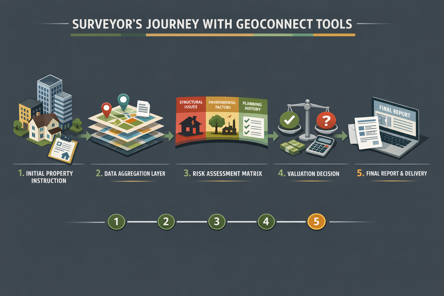
Phase 1: Instruction and Initial Data Pull
When a surveying practice receives an instruction for a valuation, the GeoConnect workflow begins immediately:
Step 1: Property Identification
- Input property address and title details
- Verify boundaries and land registry information
- Confirm property type and construction period
Step 2: Automated Data Aggregation
- System queries multiple databases simultaneously
- Environmental risk assessments auto-populate
- Planning history and building control records load
- Previous survey reports (if available) are flagged
Step 3: Risk Indicator Review
- Platform highlights red flags requiring attention
- Color-coded risk matrix shows priority concerns
- Comparable property data provides context
This initial phase typically completes within 24 hours of instruction, providing surveyors with comprehensive background before scheduling site visits.[2]
Phase 2: Pre-Survey Analysis and Planning
Armed with GeoConnect's aggregated data, surveyors can conduct informed pre-survey planning:
Desktop Risk Assessment:
- Review environmental concerns against property location
- Identify structural red flags from building control records
- Note planning restrictions or conservation area requirements
- Check for previous remediation work or ongoing disputes
Tailored Inspection Planning:
- Determine whether specialist equipment is needed (thermal imaging, moisture meters, drone surveys)
- Schedule additional time for properties with complex histories
- Prepare targeted questions for property owners or agents
- Coordinate with structural engineers if significant concerns exist
For practices offering Red Book valuations or commercial property surveys, this planning phase ensures compliance with RICS standards while maximizing on-site efficiency.
Phase 3: On-Site Verification and Enhanced Reporting
The site visit becomes a confirmation exercise rather than an investigation from scratch:
Focused Inspection Approach:
- ✔️ Verify GeoConnect data against actual property conditions
- ✔️ Investigate flagged concerns with targeted examination
- ✔️ Document findings with reference to pre-identified risks
- ✔️ Collect additional evidence for areas requiring specialist follow-up
Streamlined Reporting:
- Pre-populated report sections based on aggregated data
- Clear linkage between GeoConnect findings and on-site observations
- Risk-weighted recommendations supported by documentary evidence
- Reduced time spent on background research and data gathering
Phase 4: Follow-Up and Quality Assurance
GeoConnect's value extends beyond the initial survey:
Efficient Query Resolution:
When lenders or conveyancers raise questions, surveyors can reference the comprehensive data package assembled at instruction, reducing response times from days to hours.
Reduced Additional Survey Requirements:
By identifying issues upfront, GeoConnect minimizes situations where additional surveys must be instructed mid-transaction—a primary cause of delays.[1] Properties requiring drainage surveys or boundary surveys are identified immediately, allowing parallel scheduling rather than sequential delays.
Documentation Trail:
The platform maintains a complete audit trail of information sources, supporting professional indemnity requirements and providing transparency for all parties.
Addressing the 2026 Transaction Delay Challenge
The 67% Problem: Incomplete Upfront Assessments
Research indicates that 67% of property transaction delays in 2026 stem from incomplete upfront assessments—a critical challenge that GeoConnect Tools for Upfront Valuation Insights: Reducing Delays in 2026 Building Surveys directly addresses.[4] These delays typically manifest as:
📌 Discovery of undisclosed issues mid-transaction (structural defects, planning violations, environmental concerns)
📌 Lender valuation downgrades following more detailed investigation
📌 Requirement for specialist surveys not identified initially
📌 Renegotiation cycles as new information emerges
📌 Chain collapses when delays extend beyond buyer tolerance
Traditional reactive approaches discover problems sequentially, with each finding triggering new investigations and extending timelines. GeoConnect's proactive model identifies multiple concerns simultaneously at instruction, enabling parallel resolution rather than sequential delays.
Process Efficiency Improvements
When implemented effectively, GeoConnect delivers measurable efficiency gains:
Reduced Follow-Up Queries:
Comprehensive upfront data packages answer common lender and conveyancer questions before they're asked, cutting query response cycles by an estimated 40-50%.[1]
Fewer Aborted Surveys:
Identifying deal-breaking issues before site visits prevents wasted surveyor time and allows earlier client conversations about property suitability.
Streamlined Specialist Coordination:
When structural engineering assessments or expert witness services are needed, early identification enables concurrent scheduling rather than sequential delays.
Enhanced Client Communication:
Surveyors can provide informed preliminary guidance based on GeoConnect data while awaiting site visit scheduling, managing client expectations more effectively.
Integration with Broader Property Technology
GeoConnect represents one component of the evolving 2026 surveying technology landscape:
Complementary Technologies:
- Drone surveys for roof and high-level inspections
- Thermal imaging for insulation and moisture detection
- 3D laser scanning for measured building surveys
- Digital reporting platforms for client-accessible findings
The platform's data aggregation capabilities enhance rather than replace these technologies, providing context that makes specialist assessments more targeted and cost-effective. For practices offering reinstatement cost valuations or commercial valuations, GeoConnect's comprehensive property intelligence supports more accurate assessments.
Limitations and Professional Judgment Considerations
GeoConnect as a Supporting Tool, Not a Replacement
Industry experts emphasize that GeoConnect functions as preparation rather than replacement for professional surveyor expertise.[1] Critical limitations include:
⚠️ Data currency and accuracy: Aggregated information is only as current as source databases; recent alterations may not appear
⚠️ Interpretation requirements: Raw data requires professional analysis to determine significance
⚠️ Site-specific conditions: No database can replace direct observation of property condition
⚠️ Local knowledge gaps: Experienced surveyors possess contextual understanding that databases cannot replicate
The platform enhances but does not eliminate the need for:
- Qualified surveyor site inspections
- Professional judgment in risk assessment
- Contextual interpretation of findings
- Client-specific advice tailored to intended use
When GeoConnect Adds Most Value
The platform delivers greatest benefit in specific scenarios:
High-complexity properties:
- Listed buildings with extensive alteration histories
- Properties in multiple-risk zones (flood + subsidence + contamination)
- High-rise buildings with cladding concerns
- Former commercial sites with change-of-use complications
Time-sensitive transactions:
- Chain situations where delays risk collapse
- Commercial acquisitions with tight completion deadlines
- Portfolio purchases requiring rapid assessment
Lender-driven valuations:
- Mortgage valuations requiring comprehensive risk documentation
- Buy-to-let properties where rental viability depends on condition
- Properties requiring registered RICS valuers for institutional lending
The 2026 Opportunity: Informed Decision-Making Over Reactive Assessment
Shifting Industry Practice
The surveying industry's 2026 opportunity involves moving away from reactive valuation processes toward informed choice built on strong property insight.[1] This shift requires:
Cultural change:
Viewing comprehensive upfront assessment as investment rather than cost, recognizing that thorough preparation reduces overall transaction expense through delay avoidance.
Technology adoption:
Integrating platforms like GeoConnect into standard workflows rather than treating them as optional extras for complex cases only.
Client education:
Helping property buyers and sellers understand how upfront intelligence protects their interests and accelerates transactions.
Professional development:
Training surveyors to maximize value from aggregated data while maintaining core assessment skills.
Market Sentiment and Regional Considerations
Early 2026 market conditions show regional price divergence and buyer uncertainty, making informed valuations more critical than ever.[5] Properties in areas experiencing price volatility benefit particularly from GeoConnect's comprehensive risk assessment, as:
- Buyers demand greater certainty before committing to purchases
- Lenders apply stricter valuation criteria in uncertain markets
- Sellers need realistic pricing based on disclosed property conditions
- Transaction chains become more fragile under economic pressure
For surveying practices serving multiple regions, GeoConnect's standardized data aggregation ensures consistent assessment quality regardless of local market familiarity.
Practical Implementation for Surveying Practices
Getting Started with GeoConnect Integration
Practices considering GeoConnect adoption should follow a structured implementation approach:
1. Pilot Program (Weeks 1-4):
- Select 10-15 diverse properties for initial GeoConnect use
- Compare data quality and efficiency gains against traditional workflows
- Identify integration points with existing practice management systems
- Train key staff on platform navigation and interpretation
2. Workflow Integration (Weeks 5-8):
- Develop standard operating procedures incorporating GeoConnect
- Create report templates leveraging pre-aggregated data
- Establish quality assurance checkpoints
- Define criteria for when GeoConnect adds most value
3. Full Deployment (Weeks 9-12):
- Roll out to all surveyors conducting building surveys
- Monitor efficiency metrics (time savings, query reduction, client satisfaction)
- Refine workflows based on user feedback
- Communicate value proposition to clients and referral sources
Cost-Benefit Analysis
While GeoConnect involves subscription costs, the return on investment derives from:
💰 Reduced surveyor time on background research and data gathering
💰 Fewer aborted surveys due to earlier identification of deal-breaking issues
💰 Lower professional indemnity risk through more comprehensive documentation
💰 Increased throughput as surveys complete faster with fewer delays
💰 Enhanced reputation for thorough, efficient service delivery
For practices handling significant volumes of Level 2 and Level 3 surveys, even modest efficiency gains compound into substantial annual savings.
Conclusion
GeoConnect Tools for Upfront Valuation Insights: Reducing Delays in 2026 Building Surveys represents a fundamental evolution in how surveying practices approach property assessment. By consolidating multi-source data at the point of instruction, the platform addresses the root cause of 67% of transaction delays—incomplete upfront information—while maintaining the central role of professional surveyor judgment.[4]
The platform proves particularly valuable for complex valuations involving high-rise buildings, properties with environmental risks, or structures with complicated histories. Through systematic pre-survey data aggregation, risk-weighted analysis, and streamlined reporting, GeoConnect enables surveyors to deliver faster, more comprehensive assessments without compromising quality.
Actionable Next Steps
For surveying practices seeking to enhance efficiency in 2026:
✅ Evaluate current delay patterns in your practice—identify how many stem from incomplete upfront information
✅ Request a GeoConnect demonstration focused on your typical property types and complexity levels
✅ Pilot the platform on 10-15 diverse properties to measure actual efficiency gains
✅ Develop integration workflows that leverage GeoConnect data while maintaining professional assessment standards
✅ Communicate the value to clients, emphasizing how comprehensive upfront intelligence protects their interests
The opportunity lies not in replacing professional expertise with technology, but in providing surveyors with better information earlier, enabling informed decisions that reduce delays and enhance transaction certainty. As the industry continues evolving toward proactive risk assessment, platforms like GeoConnect will increasingly define the standard for thorough, efficient property valuation in complex cases.
For practices committed to delivering exceptional service in an increasingly competitive market, integrating comprehensive property intelligence tools represents not just an efficiency improvement, but a strategic necessity for 2026 and beyond.
References
[1] 2026 Forecasts Technology And Surveying – https://mortgagesoup.co.uk/2026-forecasts-technology-and-surveying/
[2] Technology For Early Property Insight In 2026 Building Surveys Reducing Delays In Complex Valuations – https://nottinghillsurveyors.com/blog/technology-for-early-property-insight-in-2026-building-surveys-reducing-delays-in-complex-valuations
[3] The Future Of Land Surveying Technology And Upcoming Trends In 2026 – https://metricop.com/blogs/land-surveying/the-future-of-land-surveying-technology-and-upcoming-trends-in-2026
[4] Technology For Upfront Property Understanding In Building Surveys Beyond Geoconnect To Holistic Risk Assessment – https://nottinghillsurveyors.com/blog/technology-for-upfront-property-understanding-in-building-surveys-beyond-geoconnect-to-holistic-risk-assessment
[5] Building Survey Market Sentiment In Early 2026 Navigating Regional Price Divergence And Buyer Uncertainty – https://nottinghillsurveyors.com/blog/building-survey-market-sentiment-in-early-2026-navigating-regional-price-divergence-and-buyer-uncertainty