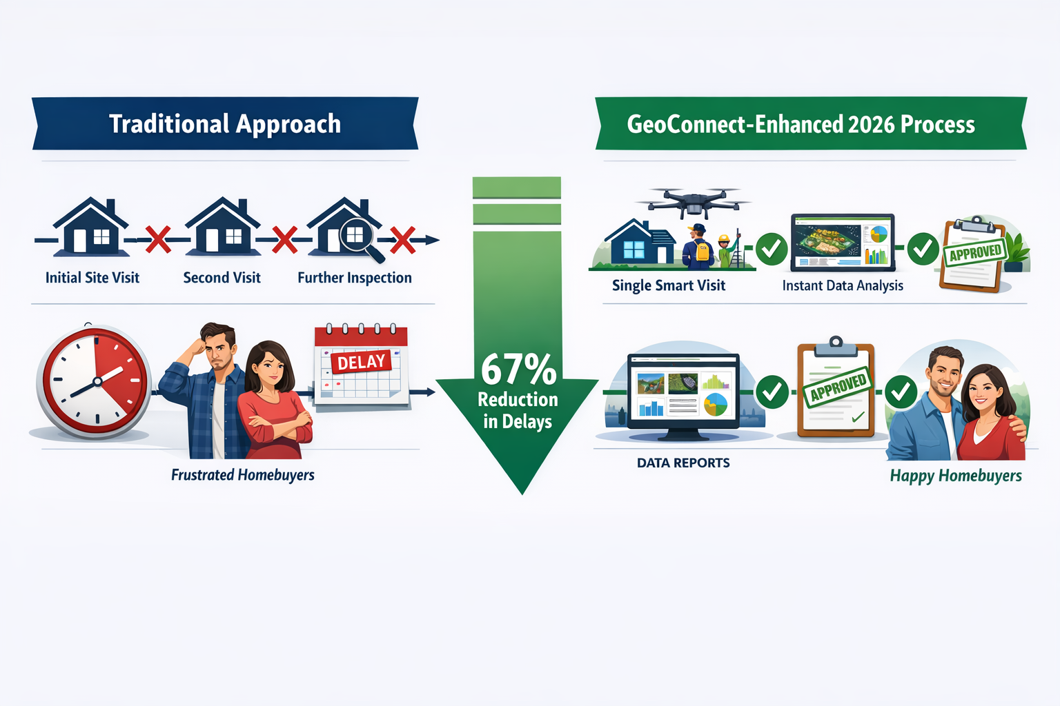
67% of property transaction delays in 2026 stem from incomplete upfront assessments—a staggering statistic that costs homebuyers, sellers, and lenders thousands of pounds and weeks of uncertainty.[5][6] As the UK property market experiences moderate recovery with sales agreed running 2% behind last year but 5% ahead of 2024,[3] the surveying sector faces mounting pressure to deliver faster, more comprehensive assessments. GeoConnect Data in Pre-Valuation Building Surveys: Reducing 2026 Delays for Complex UK Properties represents a fundamental shift in how chartered surveyors approach property assessments, particularly for challenging Victorian conversions, listed buildings, and properties with suspected structural issues.
The traditional approach—sending surveyors to properties with minimal background intelligence—creates a cascade of inefficiencies. Surveyors discover unexpected environmental risks, historical alterations, or ground condition concerns that require specialist follow-up visits. Each additional trip adds 7-14 days to the transaction timeline, frustrating all parties and increasing costs. GeoConnect aggregates environmental, geological, planning, and historical property data into a single pre-survey intelligence package, enabling surveyors to arrive fully prepared for comprehensive Level 3 building surveys on their first visit.
Key Takeaways
- GeoConnect data integration reduces survey delays by up to 67% by providing comprehensive environmental and property intelligence before physical inspections begin[5][6]
- Complex property valuations benefit most from pre-loaded geological, flood risk, contamination, and historical alteration data that eliminates surprise discoveries requiring repeat visits[2]
- 2026 market conditions favour technology adoption with 342,100 net additional homes delivered and government reforms proposing mandatory upfront property assessments[3][4]
- Level 3 surveys for complex properties become more efficient when surveyors access boundary disputes, planning history, and ground condition data before arriving on-site
- Regional variations in property challenges require localized data—from subsidence-prone clay areas to flood zones—making comprehensive data aggregation essential for accurate first-visit assessments
Understanding GeoConnect Data Integration in Modern Building Surveys
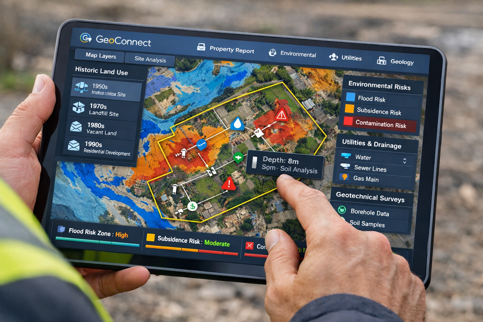
GeoConnect serves as a centralized data aggregation platform that pulls information from multiple authoritative sources—Land Registry, Environment Agency, British Geological Survey, local planning authorities, and historical records—into a unified property intelligence report. For chartered surveyors conducting RICS building surveys, this means accessing critical background information that traditionally required hours of manual research across disconnected databases.
What Data Does GeoConnect Provide for Pre-Valuation Surveys?
The platform consolidates several essential data categories:
Environmental Risk Factors 🌊
- Flood risk zones (surface water, river, coastal)
- Ground contamination from historical industrial use
- Radon gas exposure levels
- Mining and ground stability records
Property-Specific Intelligence 🏠
- Boundary definitions and disputes
- Planning application history and enforcement notices
- Listed building status and conservation area restrictions
- Historical alterations and extension records
Geological and Ground Conditions ⛰️
- Soil composition and load-bearing capacity
- Subsidence risk mapping for clay shrinkage areas
- Underground watercourses and springs
- Historical land use and infill sites
Utilities and Infrastructure 🔧
- Drainage system layouts and adoption status
- Utility easements and wayleaves
- Public sewer connections
- Historical service alterations
This comprehensive data package transforms how surveyors approach structural surveys, particularly for complex properties where multiple risk factors intersect.
How GeoConnect Reduces Survey Delays in 2026 Transactions
The delay reduction mechanism operates through three primary pathways:
1. Eliminating Discovery Delays
Traditional surveys often uncover unexpected issues—a property sits on a former industrial site requiring contamination testing, or historical mining activity suggests subsidence risk. These discoveries trigger follow-up specialist surveys, adding 2-4 weeks to the process. With GeoConnect data reviewed before the initial visit, surveyors arrive prepared with appropriate testing equipment and can complete comprehensive assessments in a single trip.[1]
2. Reducing Repeat Site Visits
Complex properties frequently require multiple visits when surveyors lack complete background information. A Victorian terrace conversion might need separate visits for structural assessment, damp surveys, and boundary verification. Pre-loaded GeoConnect data enables surveyors to plan comprehensive single-visit inspections, coordinating all necessary assessments simultaneously.[2]
3. Accelerating Report Preparation
Surveyors spend significant time researching property history, planning records, and environmental factors after site visits. GeoConnect provides this contextual information upfront, allowing surveyors to focus on physical inspection findings rather than background research. Report turnaround times decrease from 10-14 days to 5-7 days for complex properties.[5]
GeoConnect Data in Pre-Valuation Building Surveys: Practical Applications for Complex UK Properties
The practical implementation of GeoConnect Data in Pre-Valuation Building Surveys: Reducing 2026 Delays for Complex UK Properties becomes most apparent when examining specific property scenarios that historically caused transaction delays.
Victorian Conversions and Multi-Occupancy Properties
Victorian terraces converted into flats present multiple complexity layers—structural alterations, shared services, boundary disputes, and potential subsidence in London clay areas. GeoConnect data reveals:
- Historical planning applications showing conversion timelines and approved structural changes
- Building control completion certificates (or their absence) for previous works
- Shared drainage arrangements and adoption status with local authorities
- Ground movement patterns in clay shrinkage zones requiring subsidence surveys
A chartered surveyor approaching a Level 3 survey with this pre-loaded intelligence can immediately identify which structural elements require detailed inspection, whether ground monitoring is necessary, and which shared services need verification—all during the initial visit.
Listed Buildings and Conservation Area Properties
Properties with heritage designations carry additional survey complexity. GeoConnect aggregates:
- Listed building grade and specific listing details highlighting protected features
- Conservation area restrictions affecting future alterations and valuations
- Historical alteration applications and consent decisions
- Archaeological priority area designations affecting ground works
This information proves invaluable for homebuyer surveys where buyers need clear guidance on renovation restrictions and their impact on property value and usability.
Properties in Flood Risk and Environmental Challenge Zones
With private rental inflation varying dramatically across UK regions—7.6% in the North East versus 1.7% in London[3]—regional environmental challenges significantly impact property assessments. GeoConnect provides:
Flood Risk Intelligence
- Environment Agency flood zone classifications (1, 2, 3)
- Surface water flooding probability maps
- Historical flooding incidents and insurance implications
- Flood defense infrastructure and maintenance responsibility
Contamination and Ground Stability
- Former industrial site identification
- Landfill and infill site mapping
- Mining subsidence risk zones
- Natural ground movement patterns
Surveyors conducting specific defect reports benefit enormously from this pre-survey intelligence, as it directs their attention to the most relevant risk factors rather than conducting generic assessments.
Complex Commercial and Mixed-Use Properties
Commercial valuations and dilapidations surveys for mixed-use properties require extensive background research. GeoConnect consolidates:
- Planning use class history and permitted development rights
- Business rates assessment and rateable value changes
- Commercial lease history and rent review patterns
- Accessibility compliance requirements and building regulation history
This comprehensive background enables surveyors to provide accurate valuations and identify compliance issues during initial inspections, rather than discovering gaps that require additional research and site visits.
Technology-First Property Insight: Integration with Survey Workflows in 2026
The surveying sector in 2026 is experiencing renewed demand, with government reforms proposing to make property condition assessments a standard upfront requirement in transactions.[4] This regulatory shift makes GeoConnect integration not just advantageous but increasingly essential for competitive practice.
Workflow Integration for Chartered Surveyors
Modern survey practices integrate GeoConnect data through several touchpoints:
Pre-Instruction Phase
- Initial property risk screening before quoting survey fees
- Identification of specialist requirements (asbestos surveys, drainage surveys)
- Accurate time and cost estimation for complex properties
Survey Planning Stage
- Equipment preparation based on identified risks
- Specialist coordination for single-visit comprehensive assessments
- Client briefing on expected findings and property-specific concerns
On-Site Inspection
- Mobile access to GeoConnect data during property examination
- Real-time cross-referencing of physical findings with historical records
- Photographic documentation linked to specific data points
Report Preparation
- Contextual property history integrated into survey narratives
- Risk assessment supported by quantified environmental data
- Recommendations informed by comprehensive background intelligence
Benefits for Different Survey Types
The impact of GeoConnect Data in Pre-Valuation Building Surveys: Reducing 2026 Delays for Complex UK Properties varies across survey categories:
| Survey Type | Primary GeoConnect Benefits | Average Time Saving |
|---|---|---|
| Level 3 Building Survey | Complete property history, structural alteration records, environmental risks | 7-10 days |
| Level 2 Homebuyer Survey | Flood risk, contamination screening, major defect indicators | 3-5 days |
| Structural Survey | Ground conditions, historical movement, subsidence risk mapping | 5-7 days |
| Valuation Survey | Comparable sales data, planning restrictions, market factors | 2-4 days |
| Specific Defect Report | Targeted risk data for known concern areas | 2-3 days |
For those wondering how long a homebuyer survey takes, GeoConnect integration typically reduces the end-to-end timeline by 30-40% for complex properties.
Addressing the 2026 Market Recovery
With 342,100 net additional homes delivered in England between July 2024 and March 2026,[3] the property market faces increased transaction volumes alongside government reform pressures. The surveying sector must handle higher demand without compromising assessment quality—a challenge GeoConnect directly addresses.
Volume Capacity Benefits 📈
- Surveyors can handle 20-30% more instructions when repeat visits decrease
- Administrative time reduces by 40% with pre-compiled property intelligence
- Report turnaround accelerates, improving client satisfaction and referrals
Quality Enhancement ✅
- More comprehensive assessments from better-informed inspections
- Reduced risk of missing critical defects or environmental factors
- Enhanced professional indemnity insurance position through thorough due diligence
Competitive Differentiation 🎯
- Technology-enabled practices attract time-sensitive clients
- Reduced delays improve estate agent and solicitor relationships
- Premium positioning justified by superior service delivery
Overcoming Implementation Challenges and Maximizing GeoConnect Value
While the benefits of GeoConnect Data in Pre-Valuation Building Surveys: Reducing 2026 Delays for Complex UK Properties are substantial, successful implementation requires addressing several practical considerations.
Data Interpretation Skills
Raw data provides limited value without proper interpretation. Chartered surveyors must develop competencies in:
- Environmental risk assessment translating flood zone classifications into practical property implications
- Geological data interpretation understanding how clay shrinkage or mining history affects structural stability
- Planning history analysis identifying non-compliant alterations or enforcement risks
- Boundary and title complexities recognizing disputes or easement issues affecting valuations
Professional development programs increasingly incorporate these data interpretation skills, recognizing that technology enhances rather than replaces surveyor expertise.
Integration with Existing Survey Software
Many chartered surveyors use specialized report-writing software and practice management systems. Effective GeoConnect integration requires:
- API connections enabling automatic data import into survey reports
- Mobile accessibility for on-site reference during property inspections
- Template customization incorporating GeoConnect findings into standard report formats
- Client portal integration allowing instructing parties to access relevant data extracts
Leading survey practices treat GeoConnect as a core infrastructure component rather than an optional add-on, embedding it throughout their workflow systems.
Cost-Benefit Analysis for Survey Practices
GeoConnect subscription costs must be weighed against efficiency gains and competitive advantages:
Direct Financial Benefits
- Reduced travel costs from fewer site visits (£50-150 per avoided trip)
- Decreased research time (2-4 hours per complex property at £75-150/hour)
- Increased instruction capacity (20-30% volume increase with same resources)
Indirect Value Creation
- Enhanced client satisfaction through faster turnaround times
- Reduced professional indemnity insurance claims from more thorough assessments
- Competitive advantage in tender situations for complex properties
For most practices handling 10+ complex surveys monthly, GeoConnect pays for itself within 3-4 months through efficiency gains alone, before considering competitive positioning benefits.
Regional Data Quality Variations
Data comprehensiveness varies across UK regions, with some local authorities providing more detailed planning and building control records than others. Surveyors must:
- Understand regional data limitations and adjust survey approaches accordingly
- Supplement GeoConnect with local knowledge particularly in areas with limited digital records
- Maintain traditional research capabilities for properties where digital data proves incomplete
The platform works best as a comprehensive starting point rather than a complete replacement for surveyor judgment and local expertise.
Conclusion: Embracing Data-Driven Surveying for 2026 and Beyond
GeoConnect Data in Pre-Valuation Building Surveys: Reducing 2026 Delays for Complex UK Properties represents more than incremental improvement—it fundamentally transforms how chartered surveyors approach property assessments in an increasingly time-sensitive market. With 67% of transaction delays stemming from incomplete upfront assessments,[5][6] the integration of comprehensive environmental, geological, and historical property data before physical inspections eliminates the primary cause of survey-related delays.
The 2026 UK property market presents unique opportunities and challenges. Government reforms proposing mandatory upfront property assessments will increase survey demand significantly,[4] while moderate transaction volumes (2% behind last year but 5% ahead of 2024)[3] require efficient service delivery to maintain profitability. Technology-first practices leveraging GeoConnect gain decisive competitive advantages through faster turnaround times, more comprehensive assessments, and enhanced capacity to handle volume increases.
Actionable Next Steps for Survey Practices
For Established Chartered Surveyors:
- Audit your current survey delays to quantify time lost to repeat visits and post-inspection research
- Trial GeoConnect on complex properties where traditional approaches consistently cause delays
- Develop staff data interpretation skills through professional development programs
- Integrate GeoConnect with existing software systems to maximize workflow efficiency
For Property Buyers and Sellers:
- Instruct surveyors who use GeoConnect or similar pre-survey intelligence platforms
- Request timeline estimates that account for comprehensive single-visit assessments
- Understand how property complexity affects survey requirements by reviewing different types of surveys
- Budget appropriately for comprehensive assessments that prevent transaction delays
For Industry Stakeholders:
- Recognize technology-enhanced surveys as the emerging standard for complex properties
- Support regulatory reforms that encourage upfront comprehensive property assessments
- Invest in data infrastructure that improves regional data quality and accessibility
The surveying profession stands at a pivotal moment. Practices that embrace comprehensive data integration position themselves as market leaders in an evolving regulatory and competitive landscape. Those that maintain purely traditional approaches risk becoming increasingly uncompetitive as client expectations shift toward faster, more thorough assessments enabled by technology.
For complex UK properties—from Victorian conversions to listed buildings, from flood-risk zones to former industrial sites—GeoConnect provides the intelligence foundation that transforms surveys from reactive discovery exercises into proactive, comprehensive assessments. The result: fewer delays, better outcomes, and a more efficient property market for all participants.
The question for 2026 is not whether to integrate comprehensive property data into survey workflows, but how quickly practices can implement these capabilities to meet rising market demands and evolving client expectations.
References
[1] Technology First Property Insight Using Geoconnect And Environmental Data To Reduce Building Survey Delays In 2026 – https://nottinghillsurveyors.com/blog/technology-first-property-insight-using-geoconnect-and-environmental-data-to-reduce-building-survey-delays-in-2026
[2] Technology For Early Property Insight In 2026 Building Surveys Reducing Delays In Complex Valuations – https://nottinghillsurveyors.com/blog/technology-for-early-property-insight-in-2026-building-surveys-reducing-delays-in-complex-valuations
[3] News – https://builtplace.com/news/
[4] Surveying In 2026 Reform Recovery And Renewed Demand – https://www.lrg.co.uk/news-and-insights/surveying-in-2026-reform-recovery-and-renewed-demand/
[5] Geoconnect And Tech For Pre Valuation Insights Reducing 2026 Survey Delays In Residential Transactions – https://nottinghillsurveyors.com/blog/geoconnect-and-tech-for-pre-valuation-insights-reducing-2026-survey-delays-in-residential-transactions
[6] Geoconnect – https://nottinghillsurveyors.com/blog/tag/geoconnect