Boundary disagreements between neighbours have surged by over 30% since 2020, with home extensions and garden developments triggering the majority of legal disputes. When a fence line becomes a courtroom battleground, expert witness surveyors emerge as critical players who must navigate the complex intersection of professional standards, legal requirements, and physical evidence. Understanding how Expert Witness Surveyors in Neighbour Boundary Disputes: RICS Standards vs. Land Registry Evidence work together—and sometimes conflict—can mean the difference between winning and losing a costly legal battle.
The role of an expert witness surveyor extends far beyond simple measurement. These professionals must reconcile historical documents, interpret ambiguous Land Registry plans, conduct meticulous site surveys, and present findings that withstand cross-examination in court. This article explores the essential duties of expert witnesses in boundary disputes, the rigorous RICS standards they must follow, and how they integrate Land Registry evidence with on-site investigation to provide courts with reliable, impartial testimony.
Key Takeaways
- RICS Accreditation sets mandatory professional standards for expert witnesses, requiring specialized training and adherence to the Expert Witness Accreditation Scheme (EWAS-UK) updated in March 2026[4]
- Land Registry title plans show only "general boundaries" and explicitly do not determine exact legal boundary positions, creating significant evidential limitations[2]
- CPR Part 35 compliance requires expert witnesses to provide independent, impartial evidence to the court rather than acting as advocates for the party instructing them
- Extrinsic evidence including historical maps, aerial photographs, and site surveys becomes crucial when Land Registry documents prove insufficient[2]
- Specialized boundary expertise differs fundamentally from general surveying or party wall work, requiring specific qualifications and court experience
Understanding the Role of Expert Witness Surveyors in Neighbour Boundary Disputes
What Makes a Surveyor an "Expert Witness"?
Not every chartered surveyor qualifies as an expert witness in boundary disputes. The distinction carries significant legal and professional weight. An expert witness surveyor must possess demonstrated specialist knowledge, practical experience, and the ability to provide impartial, independent evidence that assists the court in reaching a decision[4].
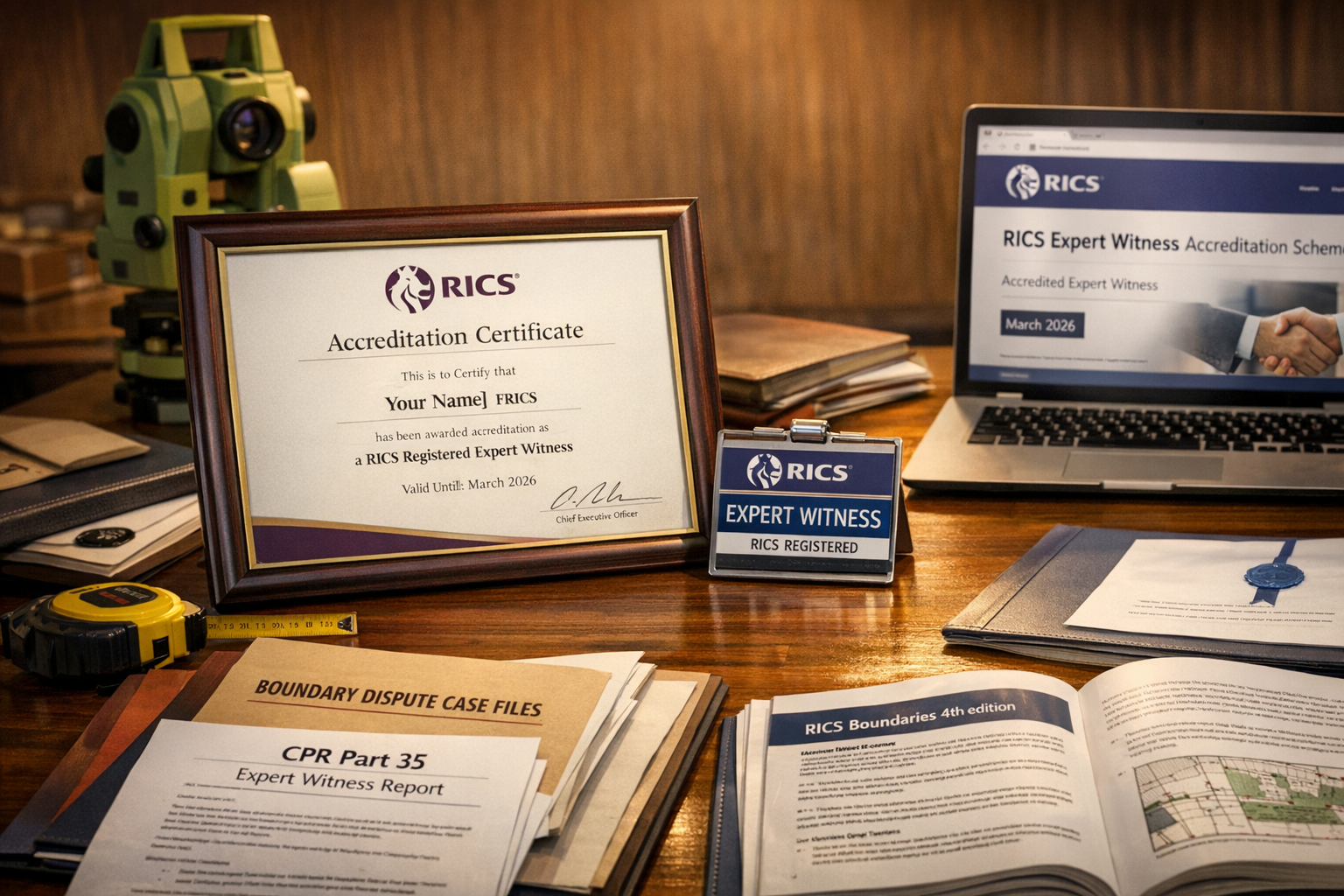
The RICS Expert Witness Accreditation Scheme (EWAS-UK) establishes voluntary but highly recommended standards for professionals acting in this capacity. As of March 2026, the RICS maintains a current register of accredited expert witnesses who have met rigorous criteria including:
- Specialized boundary work experience with proven track record in boundary identification and dispute resolution
- Mandatory expert witness training covering legal procedures, report writing, and courtroom testimony[5]
- Proficiency in interpreting historical documents, aerial photographs, and mapping evidence
- Familiarity with Civil Procedure Rules (CPR Part 35) governing expert evidence
- Demonstrated court experience providing testimony and withstanding cross-examination
The accreditation scheme aims to establish universal standards across the property and built environment sector, ensuring that expert witnesses maintain professional competence and ethical standards[4].
Expert Witness vs. Party Wall Surveyor: Critical Distinctions
Many property owners mistakenly believe that any surveyor handling neighbour disputes can serve as an expert witness in boundary cases. This confusion stems from the overlap between party wall matters and boundary issues, but the roles differ fundamentally.
Party wall surveyors work under the Party Wall etc. Act 1996, facilitating agreements between neighbours for building works affecting shared structures. Their role is quasi-judicial but primarily administrative, focused on preventing disputes rather than resolving them in court.
Expert witness surveyors in boundary disputes operate under entirely different legal frameworks:
| Aspect | Party Wall Surveyor | Expert Witness Surveyor |
|---|---|---|
| Legal Framework | Party Wall etc. Act 1996 | Civil Procedure Rules Part 35 |
| Primary Duty | To both property owners | To the court |
| Role | Facilitate agreement | Provide impartial evidence |
| Appointment | By property owners | By solicitors/court |
| Output | Party Wall Award | Expert Report for litigation |
| Advocacy | May advocate for fair resolution | Must remain entirely impartial |
This distinction matters enormously. An expert witness must never act as an advocate for the party instructing them, whereas party wall surveyors may appropriately represent their appointing owner's interests within statutory constraints.
The Overriding Duty to the Court
The cornerstone principle governing expert witness surveyors is their overriding duty to the court, which supersedes any obligation to the party paying their fees. CPR Part 35 explicitly states that expert evidence should be independent, unbiased, and provided to assist the court rather than to support a particular party's case.
This requirement creates unique professional challenges:
- 🔍 Impartiality under pressure: Instructing solicitors may push for favorable interpretations, but expert witnesses must resist advocacy
- 📊 Balanced reporting: Expert reports must acknowledge evidence that contradicts the instructing party's position
- ⚖️ Professional independence: Financial arrangements must not compromise objectivity
- 🎯 Scope limitation: Experts must only provide opinions within their genuine area of expertise
For those seeking expert witness services, understanding this fundamental duty helps set realistic expectations about what an ethical expert can and cannot provide.
RICS Standards for Expert Witness Surveyors in Neighbour Boundary Disputes
The RICS Boundaries Guidance (4th Edition)
Expert witnesses handling boundary disputes must follow the current RICS professional standard: Boundaries: procedures for boundary identification, demarcation and dispute resolution (4th edition)[3]. This comprehensive guidance establishes best practice for:
- Boundary identification methodology including documentary research and site investigation
- Survey techniques appropriate for boundary determination
- Evidence hierarchy when multiple sources conflict
- Reporting standards for boundary opinions
- Ethical considerations in contentious situations
The 4th edition reflects evolving case law and technological advances in surveying, including the use of GPS, aerial photography analysis, and digital mapping tools. Expert witnesses who fail to demonstrate familiarity with this guidance risk having their evidence challenged or dismissed.
Mandatory Training and Continuing Professional Development
RICS members must complete specific expert witness training before providing evidence in boundary disputes[5]. This requirement ensures professionals understand:
- Legal frameworks governing expert evidence
- Court procedures and expectations
- Report writing standards for CPR Part 35 compliance
- Cross-examination techniques and courtroom conduct
- Ethical obligations and conflict management
Beyond initial training, accredited expert witnesses must maintain continuing professional development (CPD) in both boundary surveying techniques and expert witness practice. The March 2026 RICS register reflects this commitment to ongoing competence[4].
Site Survey Protocols and Methodology
RICS standards establish rigorous protocols for conducting boundary surveys in dispute situations[5]. Expert witness surveyors must:
Document existing conditions thoroughly:
- Photograph all relevant boundary features from multiple angles
- Measure and record fence positions, walls, hedges, and other physical markers
- Note evidence of historical boundary positions (post holes, vegetation lines, wear patterns)
- Record neighbouring property features visible from the site
Conduct dimensional analysis:
- Measure property dimensions against title deed descriptions
- Compare site measurements with historical plans and maps
- Identify discrepancies between documentary evidence and physical features
- Calculate measurement tolerances and potential error margins
Integrate multiple evidence sources:
- Overlay historical Ordnance Survey maps with current site conditions
- Analyze aerial photograph sequences showing boundary evolution
- Compare Land Registry title plans with deed plans and conveyance documents
- Assess consistency across different evidence types
The surveyor's methodology must be transparent, repeatable, and defensible under cross-examination. Any deviation from standard protocols requires clear justification in the expert report.
Land Registry Evidence in Boundary Disputes: Capabilities and Limitations
The "General Boundaries Rule" and Its Implications
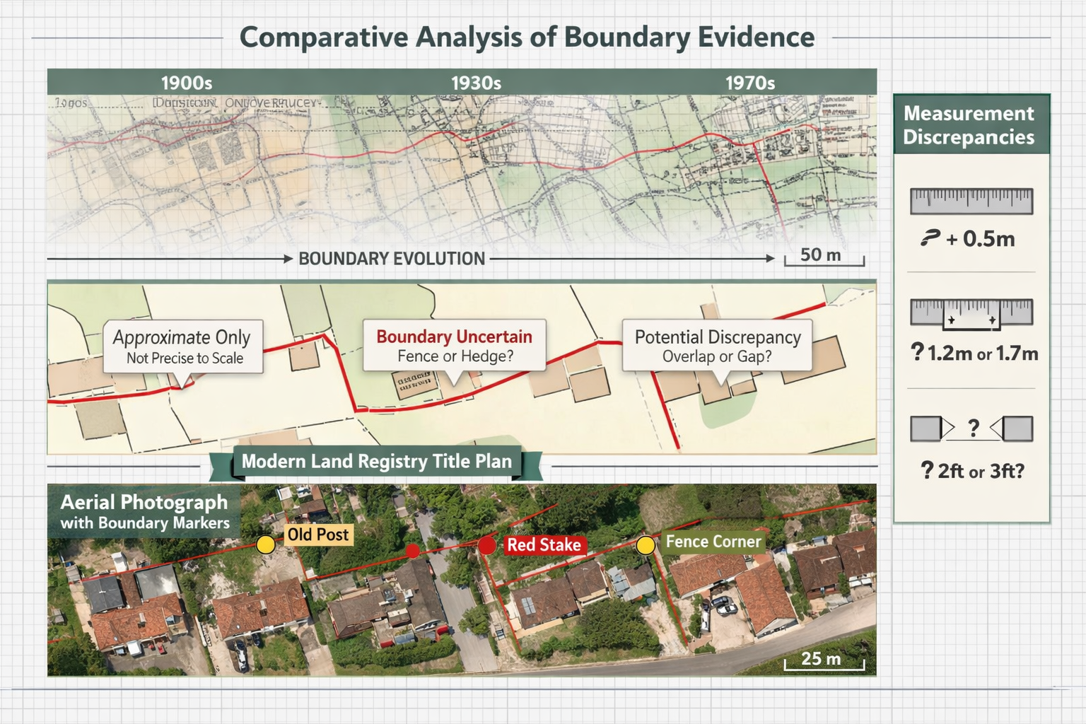
Perhaps the most misunderstood aspect of boundary disputes involves the limitations of Land Registry title plans. The Land Registry operates under the "general boundaries rule," which has profound implications for dispute resolution.
Under this rule, the red line on title plans shows only the general boundary and explicitly does not determine the exact legal boundary position[2]. This means:
- ❌ The plan does not show whether a boundary includes a hedge, wall, or ditch
- ❌ The plan does not indicate whether the boundary runs along the center, inner face, or outer face of a wall
- ❌ The plan does not provide measurements accurate enough to resolve disputes over inches or even feet
- ❌ The plan does not constitute definitive evidence of boundary position
Case law has established that there is no limit to the amount of land that can fall within the general boundaries rule[2]. Even substantial variations—potentially several feet or more—may be consistent with the general boundary shown on a title plan.
This limitation creates significant challenges for expert witnesses. While Land Registry plans provide useful context, they rarely resolve boundary disputes definitively.
Extrinsic Evidence: When Land Registry Documents Aren't Enough
When Land Registry plans prove insufficient, courts follow established procedures for examining additional evidence[2]:
Primary examination:
- Original conveyance documents and deed plans
- Property descriptions in title deeds
- Measurements and bearings specified in legal documents
Extrinsic evidence (if primary documents remain unclear):
- Historical Ordnance Survey maps showing boundary evolution
- Previous title plans from different registry periods
- Aerial photographs documenting changes over time
- Site features and physical evidence of long-established boundaries
- Expert surveyor interpretation of all available evidence
Expert witnesses specializing in boundary disputes play a crucial role in interpreting this extrinsic evidence[2]. Their expertise helps courts understand:
- How historical maps relate to current site conditions
- Whether physical features align with documentary descriptions
- The significance of measurement discrepancies
- Likely explanations for conflicting evidence
For property owners seeking guidance, the RICS Helpline Scheme provides access to impartial expert advice about boundary disputes, including free initial consultations[1].
Determined Boundaries: The Exception to the Rule
While most boundaries remain "general," property owners can apply to the Land Registry for a determined boundary—an exact line fixed by precise survey and legal process. This involves:
- Commissioning a detailed boundary survey by a qualified surveyor
- Submitting precise plans and supporting evidence
- Notifying adjoining owners who may object
- Potentially defending the application against challenges
Once registered, a determined boundary provides definitive evidence of the exact legal boundary position, largely eliminating future disputes. However, the process is expensive, time-consuming, and requires agreement or court determination if neighbours object.
Expert witnesses may be instructed to support or challenge determined boundary applications, requiring them to assess whether the proposed line accurately reflects legal title and historical evidence.
Preparing Expert Reports: CPR Part 35 Compliance
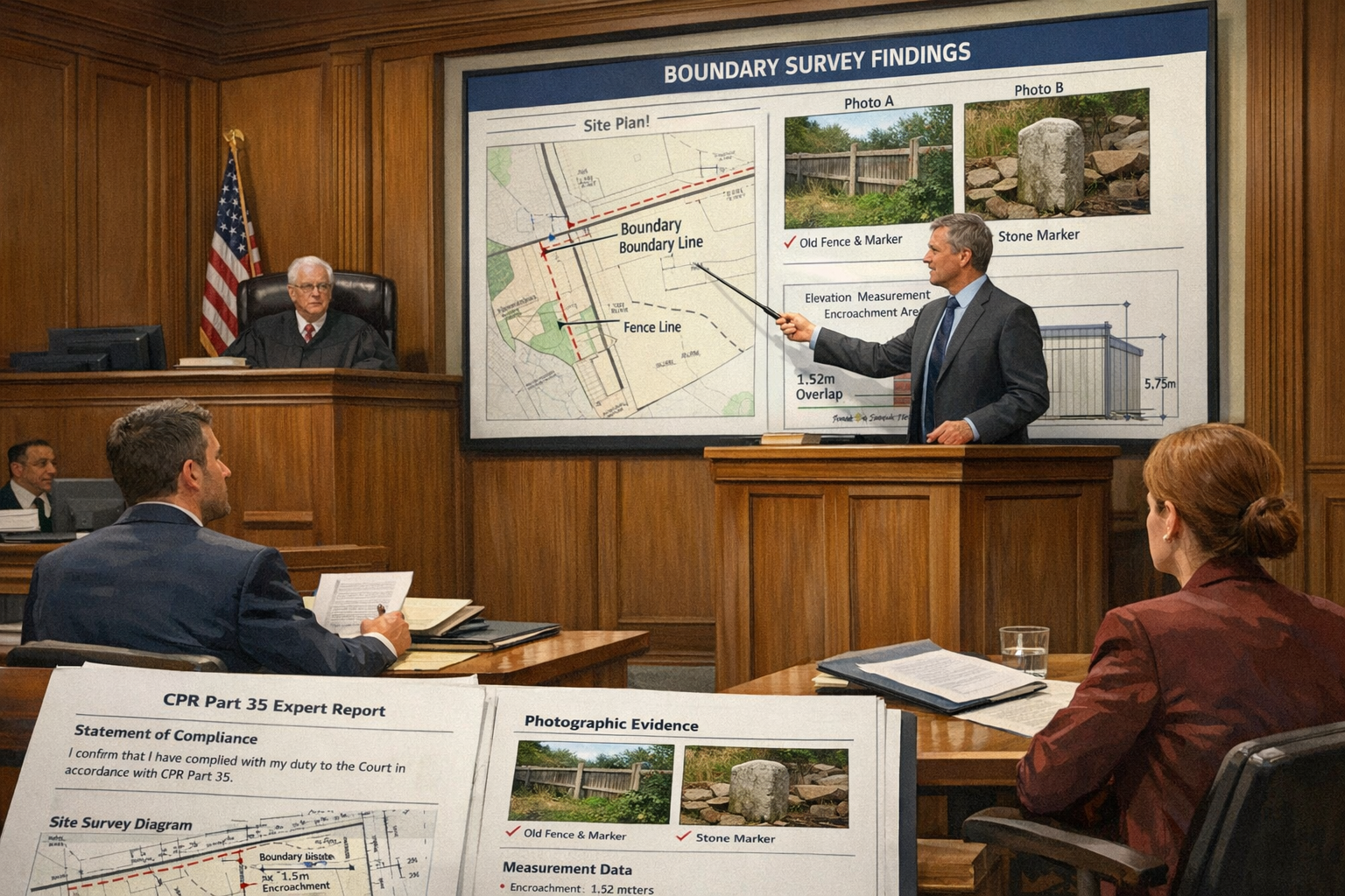
Essential Components of a Boundary Expert Report
Expert reports in boundary disputes must comply with CPR Part 35 requirements while addressing the specific technical issues involved. A comprehensive report typically includes:
1. Expert's Qualifications and Experience
- Professional qualifications (MRICS, FRICS)
- Specialist boundary dispute experience
- Court experience and previous expert witness appointments
- Relevant training and accreditation
2. Instructions and Scope
- Summary of instructing solicitor's brief
- Documents and evidence reviewed
- Site visits conducted and dates
- Limitations on scope or access
3. Factual Background
- Property descriptions and ownership history
- Timeline of the dispute
- Summary of parties' positions
- Relevant planning history or building works
4. Documentary Evidence Analysis
- Title deeds and conveyance documents
- Land Registry title plans and descriptions
- Historical Ordnance Survey maps
- Aerial photographs and previous surveys
- Comparison and reconciliation of sources
5. Site Investigation Findings
- Physical boundary features identified
- Measurements and survey data
- Photographic evidence
- Observations about boundary evolution
6. Technical Analysis
- Interpretation of conflicting evidence
- Measurement accuracy and tolerances
- Assessment of boundary feature significance
- Application of legal principles (e.g., hedge and ditch rule)
7. Expert Opinion
- Probable boundary position based on all evidence
- Confidence level in conclusions
- Alternative interpretations considered
- Limitations and uncertainties acknowledged
8. Statement of Truth
- Confirmation of CPR Part 35 compliance
- Declaration of understanding of expert duties
- Signature and date
The report must be written in clear, accessible language that non-technical readers (judges, solicitors, parties) can understand. Technical jargon requires explanation, and complex survey data needs visual presentation through plans, diagrams, and annotated photographs.
Common Pitfalls and How to Avoid Them
Even experienced surveyors can compromise their expert evidence through common mistakes:
❌ Advocacy creep: Gradually adopting the instructing party's perspective rather than maintaining strict impartiality
- Solution: Regularly review evidence that contradicts your conclusions; explicitly address contrary evidence in reports
❌ Overconfidence: Expressing certainty when evidence remains ambiguous
- Solution: Clearly state confidence levels; acknowledge limitations and alternative interpretations
❌ Scope creep: Opining on matters outside genuine expertise (e.g., legal interpretation, valuation impacts)
- Solution: Strictly limit opinions to boundary identification and surveying matters; defer legal questions to counsel
❌ Inadequate site investigation: Relying primarily on documentary evidence without thorough site examination
- Solution: Conduct multiple site visits if necessary; photograph extensively; measure all relevant features
❌ Poor document management: Failing to maintain clear records of evidence reviewed and analysis conducted
- Solution: Keep detailed working files; document methodology; maintain chronological records of instruction and investigation
For those considering costs, understanding surveyor pricing helps budget appropriately for expert witness services, which typically command premium rates due to the specialized nature and litigation risks involved.
The Joint Statement Process
Courts often direct opposing expert witnesses to meet and produce a joint statement identifying:
- Points of agreement on factual matters
- Points of agreement on technical interpretation
- Remaining points of disagreement
- Reasons for disagreement
- Further information needed to resolve differences
This process serves several purposes:
- 🎯 Narrowing issues: Eliminates uncontroversial matters, focusing court time on genuine disputes
- 🤝 Promoting settlement: Demonstrates areas of common ground that may facilitate negotiation
- ⚖️ Clarifying disputes: Helps judges understand precisely what technical questions require determination
- 📊 Testing robustness: Exposes weak positions that cannot withstand peer scrutiny
Expert witnesses must approach joint statements with genuine openness to agreement where evidence supports it, while maintaining their independent opinion on contested matters. The process tests professional integrity—the ability to acknowledge valid points made by opposing experts without compromising one's own reasoned conclusions.
Integrating RICS Standards with Land Registry Evidence: Practical Application
Case Study Approach: Typical Boundary Dispute Scenario
Consider a common scenario illustrating how Expert Witness Surveyors in Neighbour Boundary Disputes: RICS Standards vs. Land Registry Evidence work together in practice:
The Dispute:
Property owners at Numbers 24 and 26 disagree about their rear garden boundary. Number 24 claims the boundary runs along the center of an old fence. Number 26 insists the boundary lies 18 inches into Number 24's garden, based on measurements from their title deed.
The Expert's Investigation:
Documentary Phase:
- Reviews both properties' title deeds and Land Registry plans
- Discovers the Land Registry plan shows only a general boundary (red line)
- Finds the original 1965 conveyance describes Number 24's garden as "50 feet in depth"
- Locates historical OS maps from 1955, 1975, and 1995 showing fence position evolution
- Obtains aerial photographs from 1990, 2005, and 2020
Site Investigation Phase:
- Measures actual garden depth: 49 feet 6 inches to current fence
- Identifies remains of earlier fence posts 18 inches beyond current fence
- Photographs vegetation line suggesting historical boundary position
- Notes that Number 26's garden shed sits very close to the disputed area
- Documents wear patterns in grass consistent with long-established fence line
Analysis Phase:
- Calculates that 49'6" falls within reasonable tolerance of "50 feet" description
- Notes that historical OS maps show fence in current position since at least 1975
- Observes that aerial photographs confirm fence position unchanged for 30+ years
- Considers hedge and ditch rule and other legal presumptions
- Weighs physical evidence of long-established boundary against deed measurements
Expert Opinion:
The expert concludes that the balance of evidence supports the boundary along the current fence position, noting that:
- The 6-inch discrepancy falls within measurement tolerances for 1965 surveying
- Physical evidence demonstrates boundary acceptance for decades
- The doctrine of adverse possession may apply if boundary has been in current position for 12+ years
- Number 26's claim relies on precise measurement accuracy that the general boundaries rule does not support
This case demonstrates how RICS-trained experts integrate documentary evidence (including Land Registry limitations) with site investigation to form balanced, defensible opinions.
When Experts Disagree: Resolving Conflicting Evidence
Boundary disputes often feature competing expert opinions, each supported by reasonable interpretation of ambiguous evidence. Courts resolve these conflicts by assessing:
Expert credibility factors:
- Qualifications and specific boundary dispute experience
- Thoroughness of investigation and documentation
- Acknowledgment of contrary evidence and limitations
- Logical consistency of reasoning
- Adherence to RICS standards and CPR Part 35 duties
Evidence quality factors:
- Reliability of documentary sources
- Accuracy of measurements and surveys
- Consistency across multiple evidence types
- Corroboration from independent sources
- Temporal proximity to boundary establishment
When expert opinions conflict, the court may:
- Prefer one expert's evidence based on superior methodology or reasoning
- Accept parts of each expert's opinion while rejecting others
- Commission a court-appointed single joint expert
- Make findings based on non-expert evidence (witness testimony, photographs)
For property owners, understanding these dynamics emphasizes the importance of instructing properly qualified experts from the outset. Engaging local chartered surveyors with specific boundary dispute experience and RICS accreditation significantly improves the likelihood of producing credible, persuasive evidence.
The Future of Boundary Dispute Resolution
Technology and professional standards continue to evolve, shaping how expert witnesses approach boundary disputes in 2026 and beyond:
Emerging technologies:
- GPS and GNSS surveying: Provides centimeter-level accuracy for boundary plotting, though legal boundaries may remain imprecise
- Drone surveys: Enables detailed aerial photography and 3D modeling of disputed areas
- LiDAR scanning: Creates precise topographical models showing subtle ground features
- Digital overlay tools: Allows sophisticated comparison of historical and current mapping
Professional developments:
- Enhanced accreditation requirements: RICS continues refining expert witness standards
- Specialized boundary training: Growing recognition that boundary work requires distinct expertise
- Alternative dispute resolution: Increasing emphasis on expert-facilitated mediation before litigation
- Determined boundary applications: Gradual increase in property owners seeking definitive boundary registration
The March 2026 update to the RICS Register of Accredited Expert Witnesses reflects these evolving standards, with enhanced requirements for technological competence and continuing professional development[4].
Despite technological advances, the fundamental challenge remains: reconciling imprecise historical evidence with modern expectations of precision. Expert witnesses must balance sophisticated survey techniques with realistic acknowledgment of inherent uncertainties in boundary determination.
Conclusion
Expert Witness Surveyors in Neighbour Boundary Disputes: RICS Standards vs. Land Registry Evidence represents a complex intersection of professional standards, legal requirements, and practical investigation. The surge in boundary disputes accompanying home extensions and garden developments makes understanding this intersection increasingly important for property owners, legal professionals, and surveyors alike.
The key insights for 2026 include:
✅ RICS accreditation and training establish essential professional standards that distinguish qualified expert witnesses from general surveyors
✅ Land Registry title plans provide only general boundaries and cannot resolve disputes requiring precision—a limitation that many property owners fail to appreciate
✅ CPR Part 35 duties require absolute impartiality and independence, with expert witnesses serving the court rather than the instructing party
✅ Comprehensive investigation combining documentary research with thorough site examination produces the most credible and defensible expert opinions
✅ Specialized boundary expertise differs fundamentally from party wall work or general surveying, requiring specific qualifications and experience
Actionable Next Steps
For property owners facing boundary disputes:
- Seek early professional advice from RICS-accredited surveyors with specific boundary dispute experience
- Gather all available documentation including title deeds, historical plans, and photographs before instructing experts
- Consider mediation with expert facilitation before proceeding to costly litigation
- Understand Land Registry limitations and avoid over-reliance on title plans for precise boundary determination
- Budget appropriately for expert witness services, recognizing the specialized nature and litigation risks involved
For solicitors instructing expert witnesses:
- Verify RICS accreditation and specific boundary dispute experience before instruction
- Provide comprehensive instructions including all relevant documents and clear scope definition
- Allow adequate time for thorough site investigation and documentary analysis
- Respect expert independence and avoid pressure for advocacy or predetermined conclusions
- Facilitate joint expert meetings early in proceedings to narrow issues and promote settlement
For surveyors considering expert witness work:
- Complete mandatory training in expert witness duties and CPR Part 35 requirements
- Pursue RICS accreditation through the Expert Witness Accreditation Scheme
- Develop specialized expertise in boundary identification, historical mapping, and dispute resolution
- Maintain rigorous independence and resist any pressure toward advocacy
- Invest in continuing professional development covering both technical advances and legal developments
The intersection of RICS standards and Land Registry evidence will continue evolving as technology advances and case law develops. However, the fundamental principles—professional competence, ethical independence, thorough investigation, and clear communication—remain constant. Expert witnesses who master these principles while staying current with technical and legal developments will continue providing invaluable assistance to courts resolving these challenging disputes.
For those requiring expert witness services in boundary disputes, engaging qualified professionals who understand both RICS standards and Land Registry evidence limitations represents the essential first step toward successful resolution. Whether through negotiated settlement or court determination, properly instructed expert witnesses help ensure that decisions rest on sound technical foundations rather than misunderstanding or incomplete investigation.
References
[1] How To Boundary Disputes – https://www.ricsfirms.com/residential/legal-issues/boundaries/how-to-boundary-disputes/
[2] Caution Urged When Taking On Boundary Disputes – https://ww3.rics.org/uk/en/journals/built-environment-journal/caution-urged-when-taking-on-boundary-disputes.html
[3] Boundary Surveys – https://interlocksurveys.co.uk/surveying-services/boundary-surveys/
[4] Rics Register Of Accredited Expert Witnesses March 2026 – https://www.rics.org/content/dam/ricsglobal/documents/surveying/RICS-Register-of-Accredited-Expert-Witnesses_March-2026.pdf
[5] Expert Witness Preparation For Boundary Disputes Rics Site Survey Protocols And Land Registry Integration – https://nottinghillsurveyors.com/blog/expert-witness-preparation-for-boundary-disputes-rics-site-survey-protocols-and-land-registry-integration