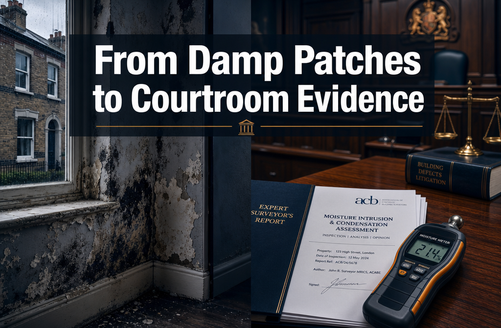
Over 40% of construction disputes that reach the Technology and Construction Court involve challenges to the quality or completeness of photographic and measurement evidence — yet the tools to eliminate those challenges have existed for years. In 2026, the integration of drones and laser scanning in expert witness building surveys has moved from innovation to expectation, with CPR-compliant evidence for defect litigation now routinely built on millions of 3D data points rather than a handful of hand measurements and selective photographs.
This guide explains how surveyors and expert witnesses can deploy drone and laser-scan technology to produce evidence that withstands cross-examination, satisfies CPR Part 35, and delivers stronger outcomes in defect disputes.
Key Takeaways 🎯
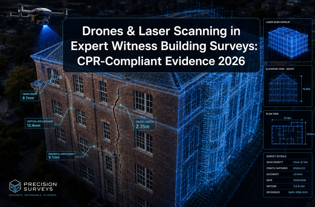
- Terrestrial laser scanning (TLS) achieves ±2–3 mm precision at short range, making it the gold-standard primary record for structural defect evidence in litigation.
- Drones extend coverage to roofs, balconies, and inaccessible façades — areas that would otherwise require costly scaffolding and extended site time.
- CPR Part 35 compliance demands transparency of method, reproducibility, and independence — all of which are directly supported by documented scan datasets and flight logs.
- Full-scene capture reduces "cherry-picked evidence" allegations because all parties can interrogate the same 3D dataset.
- AI-assisted defect detection is emerging but must be carefully documented and validated to remain CPR-compliant.
Why Traditional Survey Evidence Falls Short in Defect Litigation
Construction and building defect disputes are won or lost on the quality of evidence. Historically, expert witnesses relied on site notes, hand measurements, and photographs — methods that carry significant evidential risk.
The core problems with traditional approaches:
| Traditional Method | Evidential Weakness |
|---|---|
| Hand measurements | Human error; not reproducible |
| Selective photographs | Allegations of cherry-picking |
| Sketched drawings | Subjective interpretation |
| Single site visit | No temporal baseline |
Courts — particularly the Technology and Construction Court — increasingly expect expert evidence to be objective, reproducible, and independently verifiable. CPR Part 35 is explicit: experts must state the facts and assumptions on which their opinions are based, and their methods must be transparent enough for scrutiny.
A specialist defect survey conducted using laser scanning and drone imagery addresses every one of these weaknesses directly. The result is an evidential foundation that is harder to attack and easier for the court to understand.
💬 "Full-scene capture reduces allegations of cherry-picked photos, because opposing experts can inspect the same 3D dataset and derive their own measurements."
How Drones and Laser Scanning in Expert Witness Building Surveys Deliver CPR-Compliant Evidence for Defect Litigation 2026
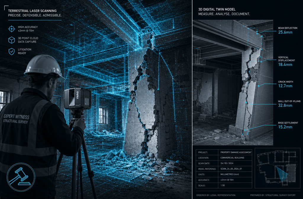
Terrestrial Laser Scanning: The Primary Evidential Record
Terrestrial laser scanning (TLS) fires millions of laser pulses per second to create a precise 3D point cloud of a structure. In 2026, TLS routinely achieves millimetre-level precision — typically ±2–3 mm at short range — making it the primary record for evidential accuracy in contentious cases [1].
For expert witness work, TLS is particularly valuable for:
- 📐 Crack mapping — precise width, depth, and orientation measurements
- 📏 Deflection analysis — quantifying beam or floor slab movement against tolerances
- 🏗️ Construction misalignment — comparing as-built geometry to design drawings
- 💧 Damp pattern documentation — when combined with thermography or moisture mapping
The critical advantage over hand measurement is reproducibility. A registered point cloud of an entire structure can be re-interrogated at any time by any party's expert. Dimensioned 2D sections and 3D models derived from the scans provide objective, traceable measurements that align directly with CPR 35's requirements for independence and transparency [4].
For cases involving floor slab movement or structural settlement, a solid floor slab survey using TLS can capture sub-millimetre level changes across the entire floor plane — evidence that is simply impossible to replicate with a spirit level and tape measure.
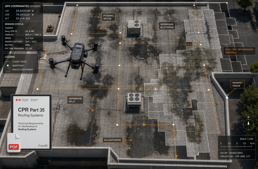
Drones: Extending Coverage to Inaccessible Areas
While TLS handles internal spaces and accessible façades, drones extend evidential coverage to roofs, high-level balconies, parapets, and external envelopes — areas that would otherwise require expensive scaffolding and extended access time [10].
In 2026, drone-based survey for expert witness purposes typically involves:
- High-resolution photogrammetry — overlapping imagery processed into orthomosaics and 3D models
- LiDAR payloads — drone-mounted laser scanning for external façades and roof structures
- Time-stamped imagery — EXIF and GNSS metadata providing a verifiable temporal record
For roof surveys in defect litigation, drone orthomosaics provide a complete, measurable record of membrane condition, ponding, parapet cracking, and flashing failures — all without the safety risks and costs of traditional access methods [9].
Key technical specifications that affect evidential weight:
| Specification | Why It Matters for Litigation |
|---|---|
| RTK/PPK GNSS | Centimetre-level absolute accuracy |
| Mechanical shutter | Eliminates rolling-shutter distortion in measurements |
| Large-format sensor | High-detail façade capture on tall buildings |
| LiDAR payload compatibility | Enables point cloud generation from drone platform |
⚠️ Important: In contentious cases, surveyors must retain raw scan files, drone EXIF/GNSS logs, flight plans, and processing reports. These form the chain of custody when drone data is challenged in cross-examination [8].
The Combined Workflow: Building a CPR-Compliant Evidence Package
The most robust approach in 2026 combines TLS and drone data into a single, integrated evidence package. Typical workflows used in high-value defect and cladding disputes follow this structure [6]:
- TLS internal survey — full point cloud registration of all accessible internal spaces and façades
- Drone external survey — orthomosaics, LiDAR, and photogrammetry of roofs and upper elevations
- Data registration — merging TLS and drone datasets into a unified coordinate system
- Derived deliverables — dimensioned 2D sections, 3D models, orthophotos, and crack maps
- Methodology documentation — calibration records, control points, QA reports, and error budgets
- Expert report integration — referencing specific scan dataset and model version numbers
This workflow directly supports the four elements of CPR-compliant defect evidence now expected in high-value disputes: (a) a registered point cloud of the entire structure; (b) time-stamped drone orthomosaics of façades and roofs; (c) dimensioned 2D sections and 3D models; and (d) a clear methodology section showing calibration, control, and QA [3].
Practical Applications in Defect Litigation
Structural Failure and Movement Cases
In cases involving structural failure, subsidence, or movement, the ability to quantify deflection and misalignment precisely is critical. A structural survey using TLS can produce colour-deviation maps showing exactly where a structure deviates from plumb, level, or design geometry — with measurements traceable to calibrated control points.
For subsidence investigations, repeat laser scanning over time creates a monitoring dataset that objectively demonstrates movement rates and patterns, strengthening causation arguments in a way that periodic hand measurements cannot [7].
Cladding and Façade Disputes
Post-Grenfell cladding disputes remain among the most complex and high-value building defect cases in the UK. Drone-based LiDAR and photogrammetry are now expected in these cases because they provide:
- Complete external envelope documentation without scaffolding
- Precise panel alignment and gap measurements
- Thermal imaging integration for insulation defect mapping
- Before-and-after comparison datasets
A schedule of condition report produced using drone orthomosaics and TLS provides an objective baseline that is far harder to dispute than a traditional photographic schedule.
Damp, Drainage, and Water Ingress Cases
Multi-layered evidence sets are increasingly standard in water ingress disputes. Drone imagery identifies external defect sources; TLS maps internal crack patterns; thermography reveals moisture distribution; and damp surveys provide moisture readings correlated to the 3D model [6].
This correlation between visible defects in the point cloud and sub-surface conditions strengthens causation arguments — a direct response to CPR's expectation that experts base opinions on a broad, coherent evidential foundation rather than a single data type.
For drainage-related defects, integrating drainage survey data with the 3D building model allows the expert to demonstrate flow paths, blockage locations, and their relationship to visible building damage in a single, coherent evidence package.
Ensuring CPR Part 35 Admissibility: Documentation and Chain of Custody
The technical quality of drone and laser-scan data is only half the battle. Evidential admissibility depends equally on documentation and chain of custody.
What Must Be Documented 📋
For laser scanning:
- Equipment make, model, and serial number
- Calibration certificates and dates
- Control point coordinates and QA reports
- Processing software, version, and settings
- Scan registration reports and error statistics
- Point cloud and model version numbers referenced in the report
For drone surveys:
- Pilot qualifications and CAA permissions
- Flight logs (date, time, weather, altitude, GNSS accuracy)
- Ground control point coordinates and accuracy
- Equipment specifications (sensor, GNSS type, shutter type)
- Raw imagery with EXIF/GNSS metadata intact
- Processing reports and orthomosaic accuracy assessments
💬 "In contentious cases, the methodology section of the expert report must be detailed enough that a technically competent opposing expert could independently verify the accuracy claims."
AI-Assisted Defect Detection: Opportunity and Risk ⚠️
In 2026, AI-assisted processing is being applied to drone and TLS data to automatically detect cracks, spalling, and moisture staining. This offers significant efficiency gains — but carries specific CPR risks [3].
Best practice for AI-assisted detection in expert witness work:
- Disclose the algorithm, software version, and detection thresholds used
- Document manual verification steps applied to automated outputs
- Avoid presenting AI-generated defect classifications as expert opinion without independent validation
- Retain the underlying dataset so that automated classifications can be checked
The court's expectation under CPR Part 35 is that the expert's opinion is their own — not an opaque algorithm's. AI tools must be positioned as processing aids, not opinion-generators.
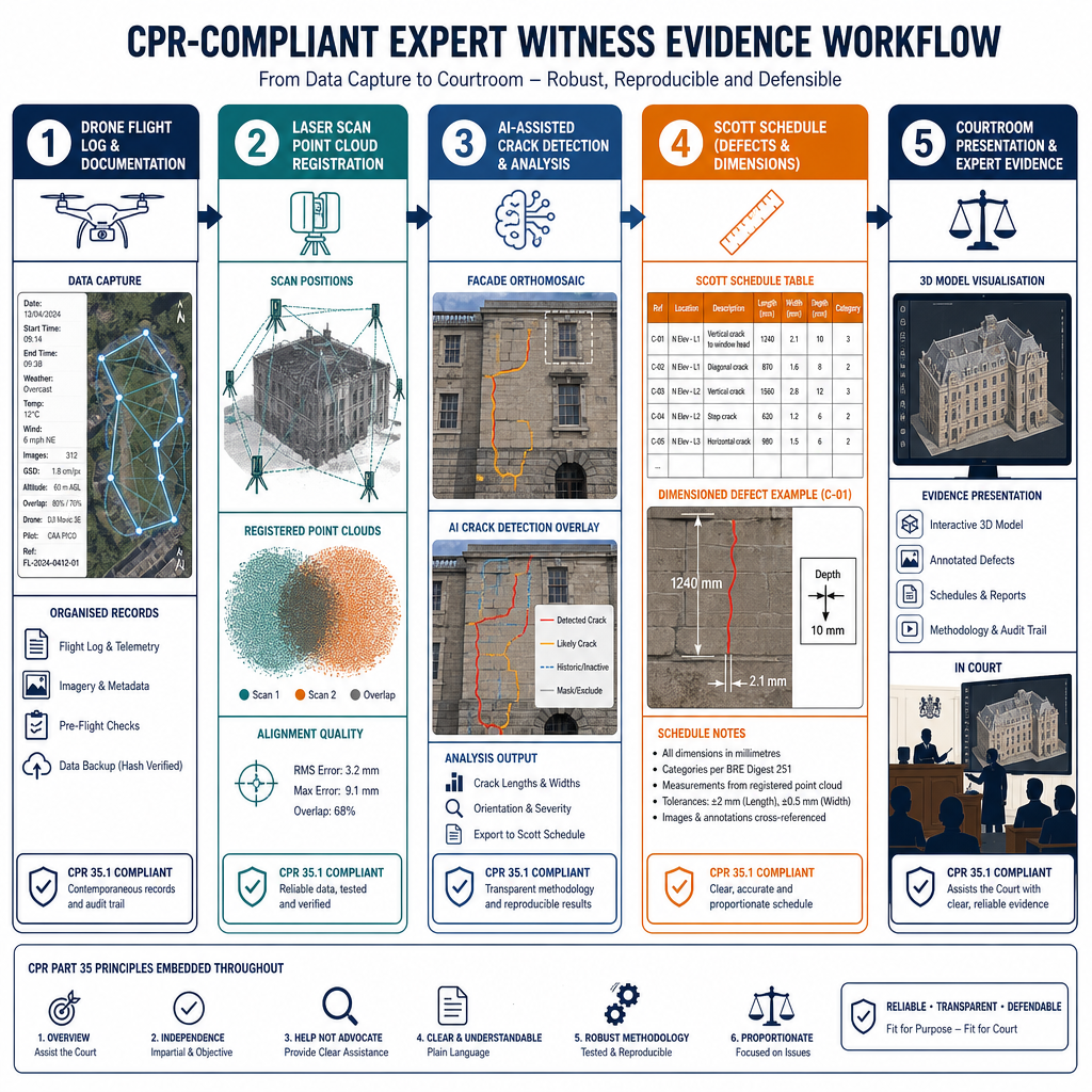
Using Scan Data in Scott Schedules and Joint Statements
One of the most practical benefits of drone and laser-scan evidence in defect litigation is its utility in Scott Schedules — the structured defect-by-defect schedules used in TCC proceedings.
When defect locations, dimensions, and measurements are derived from a registered point cloud, Scott Schedule entries become:
- Precisely located — referenced to a coordinate system, not a vague description
- Dimensioned — crack widths, deflections, and areas stated to measurable tolerances
- Reproducible — opposing experts can verify measurements from the same dataset
- Visual — 3D model extracts and orthophotos can be embedded directly in the schedule
In joint expert statements, where the court expects experts to narrow areas of disagreement, a shared 3D dataset provides a common factual reference — reducing disputes about what the defect actually is before the parties argue about its cause and remedy.
For monitoring surveys in ongoing disputes, repeat scan datasets create a time-series record that objectively demonstrates whether defects are stable, progressing, or responding to remediation — evidence that is highly persuasive in settlement negotiations and at trial.
Conclusion: Actionable Steps for Surveyors and Expert Witnesses in 2026
The shift to drones and laser scanning in expert witness building surveys is not a future trend — it is the current standard of practice for high-value defect litigation in 2026. Surveyors who continue to rely on hand measurements and selective photographs face increasing challenges to the admissibility and persuasive weight of their evidence.
Actionable Next Steps ✅
-
Invest in RTK/PPK drone platforms and TLS equipment — or partner with specialists who have them. The technical specifications of the equipment directly affect evidential weight.
-
Build documentation protocols now — flight logs, calibration records, processing reports, and version-controlled datasets must be standard deliverables, not afterthoughts.
-
Reference datasets explicitly in expert reports — cite scan dataset and model version numbers so that your opinion is traceable to objectively verifiable measurements.
-
Integrate complementary technologies — combine drone and TLS data with thermography, GPR, damp surveys, and drainage investigations to build the coherent, multi-layered evidence base that CPR Part 35 expects.
-
Treat AI tools as processing aids — document algorithms, thresholds, and manual verification steps to ensure automated outputs do not compromise your independence as an expert.
-
Engage early — the best time to commission a drone and laser-scan survey is before litigation begins, not after. A comprehensive specific defect report produced at the outset shapes the entire evidential landscape of a dispute.
The courts are moving toward expecting digital twins as the evidential baseline in complex building disputes. Surveyors who master CPR-compliant drone and laser-scan workflows in 2026 will be the expert witnesses courts trust — and the ones whose opinions carry the most weight when it matters most.
References
[1] Using Drones And Laser Scanning For As Built Surveys – https://scanm2.com/post/using-drones-and-laser-scanning-for-as-built-surveys/
[2] Drone Surveyor – https://meridiansurvey.com/drone-surveyor/
[3] Six Key Surveying Trends For 2026 Accelerating Digital Transformation – https://www.canterburysurveyors.com/blog/six-key-surveying-trends-for-2026-accelerating-digital-transformation/
[4] Drones And Laser Scanning In Level 3 Building Surveys 2026 Rics Protocols For Precision Defect Detection – https://manchestersurveyors.com/drones-and-laser-scanning-in-level-3-building-surveys-2026-rics-protocols-for-precision-defect-detection/
[6] Building Survey Technology In 2026 Gpr Drones And 3d Scanning Explained – https://redboxsurveys.co.uk/building-survey-technology-in-2026-gpr-drones-and-3d-scanning-explained/
[7] Navigating The 2026 Land Survey Equipment Boom Total Stations Gps And Laser Scanners Reviewed – https://nottinghillsurveyors.com/blog/navigating-the-2026-land-survey-equipment-boom-total-stations-gps-and-laser-scanners-reviewed
[8] Best Drones For Surveying In 2026 Duncan Parnell – https://www.duncan-parnell.com/blog/101/best-drones-for-surveying-in-2026-duncan-parnell
[9] Building Surveys With Drones And Laser Scanners – https://laboratori.eu/en/our-services/building-surveys-with-drones-and-laser-scanners/
[10] Revolutionizing Architectural Surveys The Power Of A Drone Survey Company – https://www.existingconditions.com/insights/revolutionizing-architectural-surveys-the-power-of-a-drone-survey-company