The construction and engineering industries are experiencing a fundamental shift in how project teams communicate, collaborate, and make decisions. Gone are the days when architects, engineers, and stakeholders gathered around static PDF documents and 2D blueprints, struggling to visualize complex spatial relationships and coordinate changes across multiple versions. Cloud-Based Survey Platforms: Enabling Real-Time Collaboration and 3D Visualization for Stakeholders are transforming these workflows into dynamic, interactive experiences where everyone can access the same information simultaneously, regardless of location or technical expertise.
This digital transformation isn't just about convenience—it's about fundamentally reimagining how survey data creates value throughout a project's lifecycle. When design conversations shift from traditional 2D plans to occur directly within interactive 3D models, teams achieve quicker iterations, faster workflows, and stronger alignment throughout design and construction phases.[3] For engineers and architects seeking workflow optimization, the transition to cloud-based platforms represents an opportunity to eliminate bottlenecks, reduce errors, and position themselves as essential collaborative partners rather than simple measurement service vendors.
Key Takeaways
- 🌐 Real-time collaboration eliminates version control issues by allowing multiple stakeholders to view, annotate, and discuss the same 3D model simultaneously through browser-based interfaces
- ⚡ Processing efficiency has dramatically improved, with modern platforms processing 1 square mile of survey data in approximately 30 minutes compared to over a day with traditional workflows[2]
- 📊 Unified data environments consolidate point clouds, imagery, orthophotos, 3D models, and vector maps into single platforms, eliminating data silos and reducing project overhead[2]
- 🔄 Interactive 3D visualization replaces static PDFs, enabling stakeholders without technical expertise to understand complex spatial relationships and make informed decisions
- 💼 Extended value proposition allows surveying firms to position themselves as strategic partners throughout project lifecycles, from design through long-term asset management[3]
Understanding the Shift from Static PDFs to Interactive 3D Models
The Limitations of Traditional Survey Deliverables
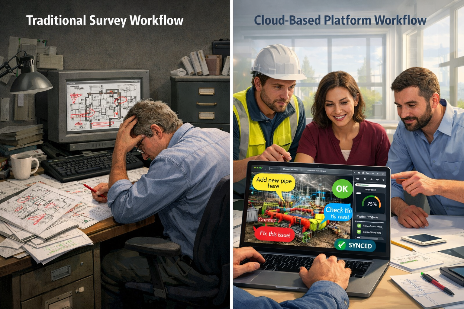
For decades, surveyors delivered their findings through static documents—PDF reports filled with technical jargon, 2D CAD drawings requiring specialized software, and printed plans that quickly became outdated. This approach created several critical challenges:
Communication barriers emerged when non-technical stakeholders struggled to interpret complex survey data. Property owners, project managers, and financial decision-makers often lacked the expertise to fully understand what they were reviewing, leading to misaligned expectations and costly misunderstandings.
Version control nightmares plagued projects as teams circulated multiple document versions via email. An architect might work from version 3 while the engineer referenced version 5, and the client reviewed version 2—creating conflicting information and coordination failures.
Limited visualization capabilities meant stakeholders couldn't truly understand spatial relationships. Reading that a wall was "2.3 meters from the property boundary" doesn't create the same understanding as seeing it rendered in accurate 3D space.
Slow iteration cycles resulted from the linear nature of traditional workflows. Each change required creating new documents, distributing them, waiting for feedback, and repeating the process—a timeline measured in days or weeks rather than hours.
The Browser-Based Revolution
Cloud-based survey platforms fundamentally address these limitations by transforming survey data into interactive, browser-accessible 3D experiences. This shift mirrors broader technology trends where cloud computing enables access to sophisticated capabilities without requiring specialized hardware or software installations.[7]
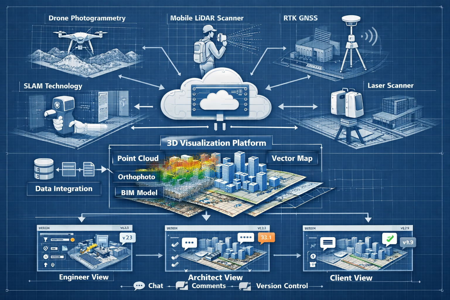
Modern platforms now consolidate all spatial data types—point clouds, imagery, orthophotos, 3D models, and vector base maps—into a single common data environment.[2] Stakeholders simply click a shared link to access professional-grade 3D visualizations directly in their web browsers, whether they're using a desktop computer, tablet, or smartphone.
This accessibility democratizes survey data. A commercial property surveyor can now share comprehensive building condition assessments with clients who can explore every detail themselves, zooming into areas of concern, measuring distances, and understanding spatial relationships without technical training.
Real-Time Collaboration Features
The true power of cloud-based platforms emerges through their collaborative capabilities:
- Simultaneous viewing: Multiple stakeholders can access the same 3D model at the same time, seeing each other's cursors and annotations in real-time
- Shared markup tools: Teams can highlight issues, add comments, and propose solutions directly on the 3D model, creating a visual conversation that's far more effective than email threads
- Instant synchronization: Changes made by one user appear immediately for all viewers, eliminating the confusion of outdated information
- Integrated communication: Many platforms include video conferencing, chat, and screen sharing, allowing teams to discuss what they're viewing without switching between applications
- Permission controls: Project managers can grant different access levels—view-only for clients, full editing for design teams, and annotation rights for reviewers
These features transform survey data from a static deliverable into a living collaboration environment where spatial data serves as a common visual language that helps all stakeholders align efforts and reduce project misunderstandings.[3]
Cloud-Based Survey Platforms: Enabling Real-Time Collaboration and 3D Visualization Through Advanced Data Processing
Multi-Sensor Data Integration
Modern cloud-based survey platforms support comprehensive data sources, maintaining compatibility with existing hardware workflows while enabling new capture methods. Leading platforms like 3Dsurvey integrate data from drones, LiDAR (both mobile and static scanners), GNSS receivers, and SLAM technology within a single processing environment.[1]
This multi-sensor approach provides several advantages:
| Data Source | Best Applications | Key Advantages |
|---|---|---|
| Drone Photogrammetry | Large area mapping, roof inspections, site progress | Cost-effective, high-resolution imagery, rapid deployment |
| Static LiDAR | Detailed building interiors, complex structures | Extreme accuracy, works in low light, captures obscured areas |
| Mobile LiDAR | Linear infrastructure, roadways, corridors | Efficient coverage, maintains traffic flow, captures vertical surfaces |
| RTK Videogrammetry | Shafts, tunnels, restricted access areas | Thousands of georeferenced frames, single walk-through capture[1] |
| SLAM Technology | Indoor spaces without GPS, underground facilities | GPS-independent, real-time mapping, portable systems |
For projects requiring structural surveys, this flexibility means surveyors can select the optimal capture method for each condition rather than forcing a one-size-fits-all approach.
Processing Speed and Efficiency Gains
Recent demonstrations have showcased remarkable processing improvements. Pointerra3D demonstrated processing capabilities of 1 square mile of data in approximately 30 minutes, including upload, calibration, classification, feature extraction (poles and wires), orthophoto creation, and digital delivery—compared to traditional workflows requiring over a day of combined processing and quality assurance.[2]
This efficiency gain fundamentally changes project economics. Surveyors can now:
✅ Deliver results the same day as data capture, enabling faster decision-making
✅ Process larger areas without proportional cost increases
✅ Iterate quickly when clients request additional analysis
✅ Reduce labor costs by automating classification and feature extraction
✅ Improve quality assurance through faster review cycles
The processing efficiency extends beyond raw speed. Automated classification algorithms can identify features like poles, wires, vegetation, and building elements with increasing accuracy through machine learning enhancement.[3] This automation doesn't replace professional judgment—it accelerates the routine work so surveyors can focus on analysis and problem-solving.
Scalable Processing Models
Cloud platforms are adopting flexible processing unit models similar to other cloud services like AWS. Pointerra3D's Digital Surveyor Bundle offers scalable Processing Unit (PU) bundles: Explorer (50 PUs) for small projects, Adopter (100 PUs) for regular users, and Pro (500 PUs) for enterprise operations.[2]
This approach provides several benefits:
🎯 Predictable budgeting: Firms know their processing costs upfront rather than facing variable per-project expenses
🎯 Scalability: Processing capacity grows with business needs without capital equipment investments
🎯 Resource optimization: Unused capacity doesn't represent wasted hardware sitting idle
🎯 Technology currency: Cloud providers continuously update processing algorithms without requiring client-side upgrades
For local chartered surveyors competing with larger firms, these scalable models level the playing field by providing enterprise-grade processing capabilities without enterprise-level infrastructure investments.
Export Standardization and Interoperability
While browser-based 3D visualization serves collaboration needs, professional workflows still require integration with specialized software. Leading platforms offer comprehensive export capabilities to standard formats including DXF, SHP, PDF, XYZ, TIFF, PLY, and OBJ for seamless integration with CAD, GIS, and regulatory systems.[1]
This interoperability ensures cloud platforms complement rather than replace existing workflows. An engineer can collaborate with stakeholders through the browser interface, then export precise measurements to CAD software for detailed design work. A planning authority can receive submissions through accessible web viewers while also obtaining formal documentation in required formats.
Workflow Optimization Examples for Engineers and Architects
Design Iteration and Revision Syncing
Traditional design workflows created frustrating delays. An architect would create a design, export it to PDF, email it to the structural engineer, wait for feedback, incorporate changes, and repeat. Each cycle consumed days, and coordination between multiple disciplines multiplied the complexity.
Cloud-based platforms transform this linear process into a parallel workflow:
- Centralized design environment: The base survey data exists in the cloud as a 3D reference model
- Concurrent access: Architects, structural engineers, MEP consultants, and clients all access the same environment
- Real-time updates: When the architect adjusts a beam location, the structural engineer sees the change immediately
- Contextual feedback: Comments and suggestions attach directly to specific 3D locations rather than vague PDF annotations
- Version history: The platform maintains a complete record of changes, allowing teams to review evolution or revert if needed
This approach particularly benefits complex projects like RICS building surveys where multiple specialists contribute findings. Rather than consolidating separate reports, all observations exist within the unified 3D model, creating a comprehensive understanding of building conditions.
Construction Progress Tracking
Reality capture is becoming an integral part of project management workflows, allowing surveyors to document conditions, visually track progress, and collaborate on solutions in real time.[3]
Progressive scan workflows enable powerful progress tracking:
- Weekly or monthly captures: Regular drone or mobile LiDAR scans create a time-series record of construction progress
- As-built vs. design comparison: Overlay actual construction against design intent to identify deviations early
- Quantity verification: Measure completed work volumes for accurate progress billing
- Issue documentation: Capture and share defects or concerns with timestamped 3D evidence
- Stakeholder transparency: Clients and investors can view current conditions remotely without site visits
For projects requiring monitoring surveys, this capability extends beyond construction to long-term structural monitoring, settlement tracking, and maintenance planning.
Client Communication and Approval Processes
Perhaps the most significant workflow improvement involves client communication. Engineers and architects traditionally struggled to convey complex spatial concepts to clients lacking technical backgrounds. This communication gap led to:
- Clients approving designs they didn't fully understand
- Expensive change orders when clients later realized implications
- Prolonged approval cycles as professionals attempted multiple explanation approaches
- Reduced client satisfaction from feeling excluded from the design process
Cloud-based 3D visualization fundamentally improves this dynamic. Clients can:
🏗️ Explore designs independently at their own pace, from any angle
🏗️ Understand spatial relationships through intuitive 3D navigation
🏗️ Identify concerns early before construction begins
🏗️ Share with stakeholders by simply forwarding a link
🏗️ Provide informed feedback based on genuine understanding
This transparency builds trust and positions professionals as collaborative partners. When a homebuyer survey identifies issues, sharing an interactive 3D model helps buyers understand the severity and location of concerns far better than written descriptions.
BIM Integration and Extended Value
Surveying firms that deliver survey data optimized for 3D visualization and building information modeling (BIM) integration are positioning themselves as essential partners in collaborative workflows rather than simple measurement service vendors.[3]
BIM-ready survey deliverables include:
- Classified point clouds with building elements identified
- Accurate as-built models suitable for design overlay
- Georeferenced data enabling precise site coordination
- Metadata-rich exports supporting facility management systems
- Continuous data environments extending beyond project completion
This extended value proposition transforms the surveyor's role. Rather than providing a one-time measurement service, surveyors become long-term data partners who establish the digital foundation for design, construction, and operations.
Common data environments now provide seamless digital handoffs at project completion, with project owners receiving rich datasets that inform long-term asset management strategies beyond traditional survey deliverables.[3] A building survey conducted during acquisition becomes the baseline for lifecycle management, renovation planning, and eventual disposition.
Specialized Application Examples
Different project types benefit from cloud collaboration in specific ways:
Heritage Documentation: Historic building surveys generate massive point cloud datasets capturing intricate architectural details. Cloud platforms enable conservation architects worldwide to examine details, plan interventions, and document restoration work without traveling to the site.
Infrastructure Projects: Linear infrastructure like roadways, railways, and utilities benefit from mobile LiDAR integration. Engineers can measure clearances, plan utility relocations, and coordinate with multiple authorities through shared 3D corridors.
Dilapidations Assessment: Dilapidation surveys require documenting existing conditions and tracking changes over lease terms. Cloud platforms create timestamped 3D records that eliminate disputes about pre-existing conditions versus tenant-caused damage.
Subsidence Monitoring: Surveys for subsidence benefit from time-series comparison capabilities, overlaying multiple scans to visualize settlement patterns and track remediation effectiveness.
Asbestos and Hazmat: Surveys for asbestos and other hazardous materials can reference 3D models to precisely document locations, enabling safe removal planning and worker protection without repeated site access.
Implementation Considerations and Best Practices
Selecting the Right Platform
Not all cloud-based survey platforms offer identical capabilities. Engineers and architects should evaluate platforms based on:
Data compatibility: Does the platform support your existing capture hardware and workflows? Can it process data from multiple sensor types?
Collaboration features: What real-time collaboration tools are included? Can multiple users simultaneously view and annotate? Are communication tools integrated or separate?
Processing capabilities: What automation is available for classification, feature extraction, and analysis? How quickly can the platform process typical project sizes?
Export options: Does the platform export to all formats your workflow requires? Can it integrate with your existing CAD, GIS, and BIM software?
Access controls: Can you manage permissions appropriately for different stakeholder groups? Is there audit logging for sensitive projects?
Pricing model: Does the pricing align with your project mix? Are there minimum commitments or pay-as-you-go options?
Support and training: What onboarding resources are available? Is technical support responsive and knowledgeable?
Performance and reliability: What uptime guarantees exist? How does the platform perform with large datasets?
Change Management and Team Adoption
Technology adoption succeeds or fails based on change management. Even the most capable platform creates no value if teams resist using it.
Effective implementation strategies include:
✓ Start with champions: Identify early adopters who understand the benefits and can demonstrate value to skeptical colleagues
✓ Pilot projects: Test the platform on smaller, lower-risk projects before committing to enterprise-wide adoption
✓ Training investment: Provide comprehensive training, not just on technical operation but on workflow integration
✓ Document benefits: Track and communicate specific improvements—time saved, errors prevented, client satisfaction
✓ Address concerns: Listen to resistance and address legitimate concerns about learning curves, data security, or workflow disruption
✓ Executive support: Ensure leadership visibly supports the transition and allocates necessary resources
Data Security and Compliance
Cloud-based platforms raise legitimate questions about data security and regulatory compliance. Professional services firms handle sensitive client information and must ensure appropriate protections.
Key security considerations include:
🔒 Encryption: Data should be encrypted both in transit and at rest
🔒 Access controls: Multi-factor authentication and role-based permissions should be standard
🔒 Data residency: Understand where data is physically stored and whether that meets regulatory requirements
🔒 Backup and recovery: What disaster recovery capabilities exist? How quickly can data be restored?
🔒 Compliance certifications: Does the platform maintain relevant certifications (ISO 27001, SOC 2, GDPR compliance)?
🔒 Client data segregation: Is client data logically separated to prevent cross-contamination?
🔒 Audit trails: Can you demonstrate who accessed what data and when?
For projects involving schedule of condition reports or other legally sensitive documentation, maintaining chain of custody and data integrity is essential.
Cost-Benefit Analysis
While cloud platforms offer compelling benefits, they represent both direct costs (subscription fees, processing units) and indirect costs (training, workflow adaptation). A thorough cost-benefit analysis should consider:
Direct cost savings:
- Reduced processing time (labor hours saved)
- Eliminated travel for coordination meetings
- Faster project delivery enabling higher throughput
- Reduced errors and rework
Indirect benefits:
- Improved client satisfaction and retention
- Competitive differentiation in proposals
- Ability to pursue larger, more complex projects
- Enhanced professional reputation
- Better risk management through documentation
Implementation costs:
- Platform subscription or processing fees
- Training and learning curve productivity loss
- Workflow redesign and documentation
- Change management effort
Most firms find the benefits substantially outweigh costs within the first year of adoption, particularly when they leverage platforms to pursue higher-value projects that weren't previously feasible.
The Future of Cloud-Based Survey Collaboration

Artificial Intelligence and Machine Learning Enhancement
Cloud-based survey platforms are increasingly enhanced by artificial intelligence and machine learning capabilities, enabling spatial data to serve as a common visual language that helps all stakeholders align efforts and reduce project misunderstandings.[3]
Emerging AI applications include:
- Automated defect detection: Machine learning algorithms identify potential structural issues, moisture intrusion, or material deterioration from point cloud and imagery data
- Predictive maintenance: Analysis of time-series scans predicts when building systems will require intervention
- Design optimization: AI suggests design alternatives that meet project requirements while optimizing cost, sustainability, or other parameters
- Intelligent classification: Automated identification and labeling of building elements, utilities, vegetation, and other features
- Natural language queries: Stakeholders can ask questions in plain language—"Where are all the HVAC units?"—and receive visual answers
These capabilities will further democratize access to survey data, allowing stakeholders without technical expertise to extract insights that currently require professional interpretation.
Extended Reality Integration
The convergence of cloud-based 3D models with augmented reality (AR) and virtual reality (VR) technologies creates powerful new collaboration modalities:
- On-site AR overlay: Field teams view design intent overlaid on actual conditions through tablets or AR glasses, immediately identifying deviations
- Remote VR collaboration: Stakeholders in different locations meet within a shared virtual environment to review and discuss 3D models
- Client presentations: Immersive VR experiences help clients understand proposed designs with unprecedented clarity
- Training and simulation: Construction teams practice complex procedures within accurate 3D environments before site work begins
Digital Twin Evolution
Cloud-based survey platforms are evolving toward comprehensive digital twin capabilities where the 3D model becomes a living representation of the physical asset throughout its lifecycle:
- Design phase: Digital twin serves as collaborative design environment
- Construction phase: Progressive scans update the twin to reflect as-built conditions
- Operations phase: Building systems integrate with the twin, providing real-time performance data
- Maintenance phase: Work orders, inspections, and repairs are documented within the spatial context
- Renovation phase: New design work references accurate current conditions
- Disposition phase: Complete facility history informs demolition, salvage, or adaptive reuse
This continuous digital thread transforms survey data from a point-in-time snapshot to a perpetual asset that accumulates value over decades.
Industry Standardization
As cloud-based collaboration becomes standard practice, industry organizations are developing interoperability standards to ensure data portability between platforms and prevent vendor lock-in. Standards like Industry Foundation Classes (IFC) for BIM data and LAS/LAZ for point clouds enable data exchange while preserving rich metadata.
This standardization benefits the entire industry by:
- Reducing switching costs between platforms
- Enabling best-of-breed tool combinations
- Protecting long-term data accessibility
- Facilitating regulatory compliance
- Supporting competitive markets
Conclusion: Embracing the Cloud-Based Collaboration Revolution
The transformation from static PDF deliverables to interactive, cloud-based 3D visualization represents far more than a technological upgrade—it fundamentally reimagines how survey data creates value throughout project lifecycles. Cloud-Based Survey Platforms: Enabling Real-Time Collaboration and 3D Visualization for Stakeholders are eliminating communication barriers, accelerating workflows, and positioning surveying professionals as essential collaborative partners rather than transactional service providers.
For engineers and architects, the workflow optimization opportunities are substantial. Real-time revision syncing eliminates version control nightmares. Browser-based 3D models enable clients to genuinely understand designs before construction begins. Multi-sensor data integration provides flexibility to select optimal capture methods for each project condition. Automated processing delivers results in hours rather than days, enabling faster decision-making and quicker project delivery.
The technology has matured beyond early-adopter experimentation into proven, production-ready platforms that integrate seamlessly with existing professional workflows. Processing capabilities that once required specialized workstations now execute in the cloud with remarkable speed and efficiency. Collaboration features that seemed futuristic just years ago are now standard expectations.
Actionable Next Steps
For professionals ready to embrace cloud-based survey collaboration, consider these concrete actions:
-
Evaluate current pain points: Identify specific workflow bottlenecks, communication challenges, or client satisfaction issues that cloud platforms could address
-
Research platform options: Request demonstrations from leading platforms, focusing on those that support your existing hardware and export to your required formats
-
Conduct a pilot project: Select a suitable project to test cloud collaboration, documenting time savings, error reduction, and stakeholder feedback
-
Invest in training: Ensure team members receive comprehensive training on both technical operation and workflow integration
-
Develop new service offerings: Consider how cloud-enabled capabilities like stock condition surveys or progressive monitoring could expand your service portfolio
-
Update marketing materials: Communicate your cloud collaboration capabilities to differentiate from competitors still delivering static PDFs
-
Gather client feedback: Actively solicit input on how interactive 3D visualization improves their understanding and decision-making
-
Monitor industry developments: Stay informed about AI enhancements, AR/VR integration, and digital twin evolution to maintain competitive positioning
The surveying profession stands at an inflection point where spatial data is becoming the universal language for project collaboration. Professionals who embrace this transformation will find themselves at the center of increasingly collaborative workflows, delivering greater value and building stronger client relationships. Those who resist risk becoming commoditized providers of raw data that others transform into actionable insights.
The tools are available. The benefits are proven. The question isn't whether cloud-based survey collaboration will become standard practice—it's whether your firm will lead this transformation or follow reluctantly behind. The time to act is now, in 2026, as this technology shifts from competitive advantage to baseline expectation.
References
[1] 3dsurvey Is The Best Photogrammetry Software In 2026 – https://3dsurvey.si/3dsurvey-is-the-best-photogrammetry-software-in-2026/
[2] Transforming The Future Of Survey Mapping – https://www.geoweeknews.com/news/transforming-the-future-of-survey-mapping
[3] Doubling Down On Digital – https://amerisurv.com/2026/02/01/doubling-down-on-digital/
[4] Top Emerging Land Surveying Technologies Shaping 2026 Drones Ai And Beyond – https://nottinghillsurveyors.com/blog/top-emerging-land-surveying-technologies-shaping-2026-drones-ai-and-beyond
[5] What Are The Best 3d Visualization Software Tools In 2026 – https://www.style3d.com/blog/what-are-the-best-3d-visualization-software-tools-in-2026/
[6] Cloud Collaboration Platform – https://www.aecplustech.com/tools/category/cloud-collaboration-platform
[7] Cad Software Cloud Era Advantage – https://www.onshape.com/en/blog/cad-software-cloud-era-advantage