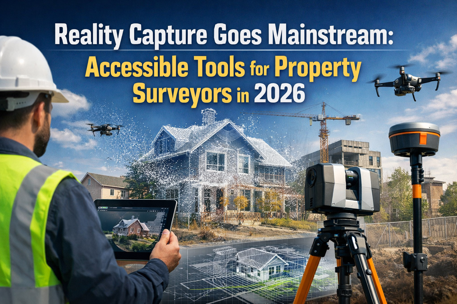
The construction industry stands at a transformative crossroads in 2026, where traditional surveying practices meet cutting-edge digital technology. BIM Integration for Land Surveyors: Seamless Collaboration in Construction Projects represents more than just a technological upgrade—it's a fundamental shift in how construction teams work together to deliver projects faster, safer, and more cost-effectively.
Imagine a construction site where every measurement, every elevation point, and every boundary marker flows seamlessly into a living, breathing digital model that all project stakeholders can access simultaneously. This isn't science fiction; it's the reality that land surveyors are creating today through Building Information Modeling (BIM) integration. As the professionals who provide the mathematically precise geospatial measurements that form the virtual foundations of BIM models, surveyors have become indispensable to modern construction success.[4]
The evidence is compelling: projects utilizing integrated BIM and surveying workflows have demonstrated 10% reductions in both costs and timelines while simultaneously improving overall quality and performance.[3] For surveyors navigating the complexities of modern construction projects, understanding and implementing BIM integration isn't just an advantage—it's becoming essential.
Key Takeaways
✅ Surveyors provide the foundational geospatial data that makes BIM models accurate and reliable, establishing them as critical players in digital construction workflows
✅ BIM integration delivers measurable results, with documented cases showing 10% cost and time savings alongside improved project quality and clash detection capabilities
✅ Real-time data capture and collaboration have become standard practice, requiring surveyors to adapt their workflows to feed spatial information directly into shared digital environments
✅ Advanced technologies like 4D and 5D BIM enable dynamic scheduling and cost control, while AI-powered predictive analytics help teams anticipate and prevent project delays
✅ Professional development in BIM skills is increasingly valuable, as demand grows for surveyors who can bridge traditional geospatial expertise with modern digital collaboration platforms
Understanding BIM Integration for Land Surveyors: Seamless Collaboration in Construction Projects
What Is BIM and Why Does It Matter for Surveyors?
Building Information Modeling (BIM) represents a comprehensive digital approach to planning, designing, constructing, and managing buildings and infrastructure. Unlike traditional 2D drawings, BIM creates intelligent 3D models that contain rich data about every component of a structure—from materials and dimensions to costs and maintenance schedules.
For land surveyors, BIM integration means capturing spatial data in formats that seamlessly feed into these collaborative digital environments.[5] The relationship between surveying and BIM is fundamentally bidirectional: BIM technology makes surveying jobs easier and more efficient, while surveying provides the accurate geospatial data that BIM requires to function properly.[4]
Key components of BIM that surveyors interact with include:
- 3D geometric models requiring precise coordinate systems and elevation data
- Geospatial reference frameworks establishing real-world positioning
- Point cloud integration from laser scanning and photogrammetry
- As-built documentation tracking construction progress against design intent
- Clash detection systems identifying conflicts between different building systems
The surveyor's role extends far beyond initial site measurements. Modern commercial property surveyors now perform continuous monitoring throughout construction, ensuring the building process remains on track and integrating updated data into evolving BIM models.[4]
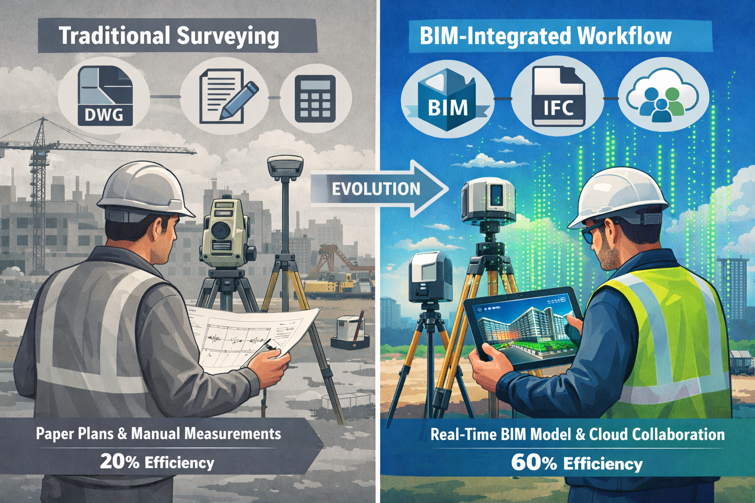
The Evolution of Surveying in the Digital Age
The surveying profession has undergone remarkable transformation over the past decade. Traditional tools like theodolites and measuring tapes have been supplemented—and in many cases replaced—by advanced technologies including:
🔧 GPS/GNSS systems providing centimeter-level accuracy
🔧 Terrestrial laser scanners capturing millions of data points per second
🔧 Unmanned aerial vehicles (UAVs) for rapid site mapping
🔧 Mobile mapping systems combining multiple sensors
🔧 Robotic total stations enabling single-operator workflows
These technological advances have positioned surveyors as data specialists rather than simply measurement technicians. In 2026, successful land surveyors understand not just how to collect accurate measurements, but how to process, format, and deliver that data in ways that maximize value for BIM-based project teams.[1]
Breaking Down Data Silos Through Integration
One of the most significant challenges in construction has historically been the fragmentation of information across disciplines. Architects work in one software environment, structural engineers in another, and surveyors in yet another—creating inefficiencies, errors, and costly rework.
BIM integration addresses this challenge by establishing a Common Data Environment (CDE) where all project information resides in accessible, interoperable formats. For surveyors, this means:
| Traditional Workflow | BIM-Integrated Workflow |
|---|---|
| Deliver CAD files via email | Upload directly to cloud-based CDE |
| Manual coordination meetings | Real-time model updates visible to all |
| Paper-based field notes | Digital data capture linked to model |
| Periodic survey updates | Continuous monitoring and integration |
| Isolated quality checks | Automated clash detection and validation |
This transformation requires surveyors to develop new competencies beyond traditional measurement skills. Understanding file formats like IFC (Industry Foundation Classes), working with point cloud processing software, and collaborating through digital platforms have become essential capabilities for professionals seeking to remain competitive.[2]
Implementing BIM Integration: Practical Steps for Land Surveyors
Step 1: Establishing the Geospatial Foundation
Every BIM model requires a precise geospatial foundation, and this is where surveyors provide irreplaceable value. The initial survey establishes the coordinate reference system that all subsequent design and construction work will follow.
Critical elements of establishing the BIM foundation include:
- Coordinate System Selection: Determining the appropriate local, regional, or global coordinate system for the project
- Control Network Establishment: Creating permanent survey monuments that enable consistent measurements throughout the project lifecycle
- Topographic Survey: Capturing existing site conditions including terrain, vegetation, utilities, and structures
- Boundary Definition: Precisely establishing property lines and easements that constrain design options
- Datum Integration: Ensuring vertical and horizontal datums align with local standards and regulations
The accuracy requirements for BIM foundation surveys typically exceed traditional surveying standards. While conventional construction surveys might accept tolerances of ±25mm, BIM-integrated projects often require ±5mm or better to ensure proper coordination between building systems.[4]
Professional chartered surveyors understand that this initial investment in precision pays dividends throughout the project by reducing conflicts, minimizing rework, and enabling automated quality control processes.
Step 2: Data Capture and Processing
Modern surveying generates massive volumes of data—a single day of laser scanning can produce billions of individual measurement points. The challenge lies not in collecting this data, but in processing it into formats that BIM platforms can utilize effectively.
The data processing workflow typically includes:
Point Cloud Registration and Cleaning 📊
Raw scan data from multiple instrument positions must be aligned into a unified coordinate system and cleaned to remove noise, vegetation, and temporary objects.
Feature Extraction 🎯
Relevant features like building edges, utility locations, and terrain breaklines are identified and extracted from the point cloud, often using semi-automated software tools.
Model Generation 🏗️
Extracted features are used to create 3D surfaces, solid models, or BIM objects that accurately represent existing conditions.
Quality Assurance ✅
Processed data undergoes validation checks comparing it against control measurements and project accuracy specifications.
Format Conversion 🔄
Final deliverables are converted into BIM-compatible formats such as Revit families, IFC files, or referenced point cloud datasets.
The efficiency of this workflow directly impacts project timelines. Surveyors who have invested in training and software tools can often complete processing within 24-48 hours of field data collection, enabling rapid design iteration and decision-making.[5]
Step 3: Integration with Design and Construction Teams
The true power of BIM Integration for Land Surveyors: Seamless Collaboration in Construction Projects emerges when geospatial data connects seamlessly with design and construction workflows. This requires establishing clear protocols for data exchange and collaboration.
Effective integration practices include:
Regular Coordination Meetings: Weekly or bi-weekly sessions where surveyors present updated site conditions and discuss implications for ongoing design work
Model Federation: Combining survey data with architectural, structural, and MEP (mechanical, electrical, plumbing) models to create comprehensive project views
Clash Detection Participation: Working with design teams to identify and resolve conflicts between existing conditions and proposed designs before construction begins
Construction Layout Support: Providing digital layout data that enables contractors to position building elements accurately using GPS/GNSS or robotic total stations
Progress Monitoring: Conducting periodic as-built surveys that compare constructed elements against design intent, identifying deviations early when corrections are less costly
This collaborative approach represents a significant cultural shift for many surveyors who have traditionally worked independently. However, those who embrace integration find themselves becoming valued strategic partners rather than mere service providers.[1]
Professionals conducting RICS commercial building surveys increasingly incorporate BIM deliverables as standard practice, recognizing that clients expect digital integration rather than traditional paper-based reporting.
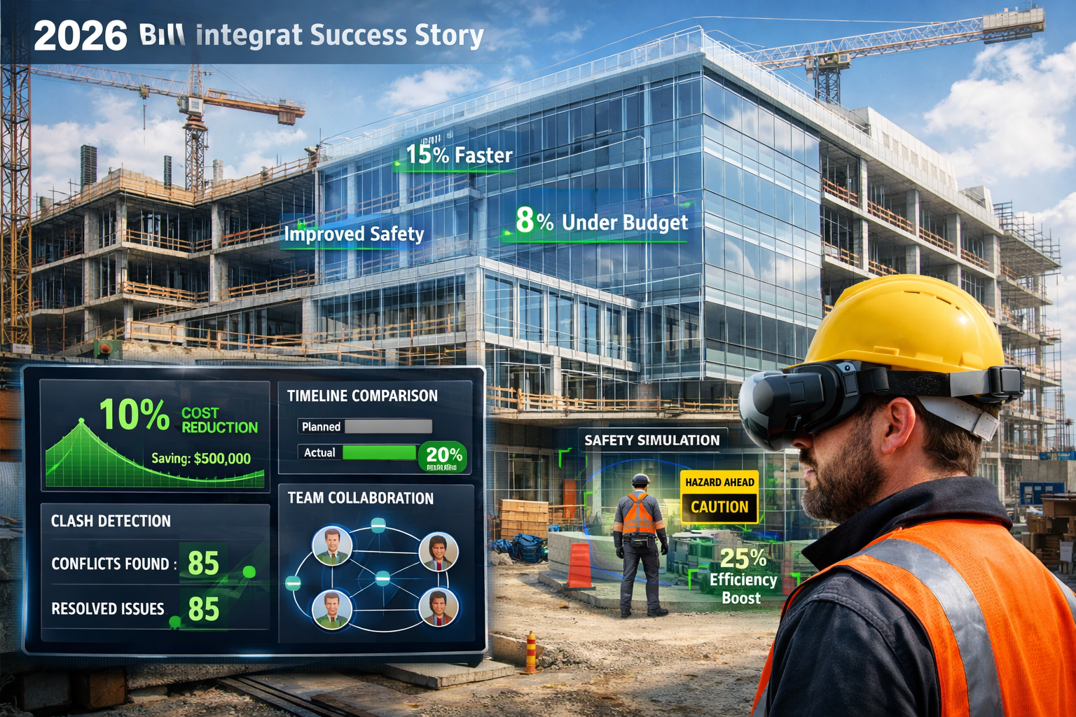
Real-World Benefits: How BIM Integration Transforms Construction Projects
Cost Reduction Through Clash Detection and Prevention
One of the most tangible benefits of BIM integration is the dramatic reduction in construction conflicts and the associated costs of resolving them. When survey data accurately represents existing conditions and integrates with design models, AI algorithms can identify clashes before construction begins.[3]
Consider these real-world scenarios from 2026 projects:
Case Study: Mixed-Use Development in Southeast London 🏙️
A surveyor's detailed utility mapping revealed underground infrastructure conflicts with proposed foundation locations. BIM clash detection identified these issues during design, enabling redesign that avoided a potential £250,000 excavation delay and emergency utility relocation.
Case Study: Industrial Facility Expansion 🏭
Laser scanning of existing structures revealed that as-built conditions differed from original drawings by up to 150mm in critical locations. Integration of accurate survey data into the BIM model allowed engineers to redesign connections appropriately, preventing costly field modifications and schedule delays.
Case Study: Highway Infrastructure Project 🛣️
Continuous survey monitoring during construction identified gradual settlement in an embankment section. Real-time integration with the BIM model triggered automated alerts, enabling corrective action before the deviation exceeded tolerance limits, saving an estimated 3 weeks of schedule and £180,000 in remediation costs.
These examples illustrate why projects utilizing BIM and surveying integration consistently demonstrate the documented 10% cost and time savings while improving quality outcomes.[3]
Enhanced Safety Through Virtual Planning
Safety represents another critical benefit area where BIM integration delivers measurable improvements. By creating detailed 3D models that incorporate accurate survey data, project teams can identify and mitigate safety hazards before workers enter potentially dangerous situations.
BIM enhances safety through:
- Virtual Reality (VR) training platforms allowing workers to experience site conditions and practice procedures in safe environments before entering actual construction zones[3]
- Augmented Reality (AR) visualization enabling workers to see underground utilities, structural reinforcement, and other hidden elements through mobile devices
- Fall hazard analysis using 3D models to identify edge conditions and plan appropriate protection systems
- Equipment clearance verification ensuring cranes, excavators, and other machinery can operate safely within site constraints
- Emergency response planning using accurate site models to develop evacuation routes and emergency access plans
Professional structural engineering teams increasingly rely on BIM-integrated survey data to analyze site conditions and design temporary works that protect both workers and existing structures during construction.
Improved Project Scheduling with 4D BIM
The evolution from 3D to 4D BIM adds the dimension of time, creating dynamic simulations of the construction process. When surveyors integrate their data into 4D models, project teams gain powerful capabilities for schedule optimization and progress tracking.
4D BIM enables:
📅 Sequence Visualization: Animated representations showing how the project will be built over time, helping identify logistical challenges and optimize work sequences
📅 Resource Allocation: Analysis of when and where equipment, materials, and labor will be needed, reducing idle time and congestion
📅 Progress Comparison: Overlaying as-built survey data onto scheduled models to visualize deviations and adjust plans proactively
📅 Stakeholder Communication: Clear visual presentations that help clients, regulators, and community members understand project timelines and impacts
The 4D system has proven particularly valuable for complex projects with multiple phases, tight site constraints, or operations that must continue during construction. Surveyors who provide timely, accurate as-built data enable these systems to function effectively, establishing themselves as essential team members.[3]
Cost Control Through 5D BIM Integration
Taking integration one step further, 5D BIM incorporates cost information into the model, enabling quantity surveyors to extract material quantities automatically and track costs against budgets in real-time.
For land surveyors, this creates opportunities to demonstrate value beyond traditional scope:
- Earthwork Optimization: Accurate terrain models enable precise cut-and-fill calculations, minimizing material hauling costs and identifying opportunities for on-site balance
- Material Quantity Verification: As-built surveys validate that installed quantities match design intent and payment applications
- Change Order Documentation: Precise measurements of field changes support fair and accurate pricing of modifications
- Value Engineering Support: Detailed existing condition data enables teams to evaluate alternative approaches and select cost-effective solutions
Understanding methods of valuation and cost control principles allows surveyors to position their services as strategic investments rather than project expenses.
Overcoming Challenges in BIM Integration for Land Surveyors

Addressing Data Interoperability Issues
Despite significant progress, data interoperability remains a persistent challenge in BIM integration. Different software platforms use proprietary formats, and translation between systems can introduce errors or lose critical information.
Surveyors can address interoperability challenges through:
Adopting Open Standards 🔓
Prioritizing file formats like IFC, LandXML, and E57 point clouds that are designed for cross-platform compatibility rather than proprietary formats tied to specific software vendors.
Implementing Quality Checks ✔️
Establishing validation procedures that verify data integrity after format conversions, including spot-checking dimensions, coordinate systems, and metadata.
Maintaining Native Formats 💾
Archiving data in original native formats alongside converted versions, ensuring that information can be recovered if translation issues emerge.
Participating in Standards Development 📋
Engaging with professional organizations and standards bodies to advocate for surveying needs in evolving BIM protocols.
AI algorithms are increasingly being employed to address data interoperability challenges, automatically detecting and correcting common translation errors while flagging issues that require human review.[3]
Managing Technology Investment and Training
The technology requirements for effective BIM integration represent significant financial and time investments. Modern surveying equipment, software licenses, computing hardware, and training programs can easily exceed £100,000 for a small firm.
Strategies for managing these investments include:
| Challenge | Solution Approach |
|---|---|
| High upfront equipment costs | Phased acquisition aligned with project needs; equipment leasing options |
| Software licensing expenses | Cloud-based subscription models; open-source alternatives where appropriate |
| Staff training time | Online learning platforms; manufacturer training programs; cross-training among team members |
| Technology obsolescence | Regular technology reviews; vendor relationships providing upgrade paths |
| Return on investment uncertainty | Starting with pilot projects; tracking metrics; documenting efficiency gains |
Professional development resources from organizations like RICS (Royal Institution of Chartered Surveyors) increasingly focus on BIM competencies, recognizing the growing demand for professionals skilled in these integrated workflows.[1]
Those seeking to understand the financial aspects of surveying services can explore resources on surveyor pricing and rates to benchmark investments appropriately.
Navigating Legal and Contractual Considerations
BIM integration introduces new legal and contractual complexities that surveyors must navigate carefully. Questions around data ownership, liability for model accuracy, and intellectual property rights require clear contractual language.
Key contractual considerations include:
Scope Definition 📝
Precisely defining what survey deliverables will be provided, in what formats, with what accuracy specifications, and on what schedule.
Data Ownership 🔐
Clarifying who owns survey data, BIM models derived from that data, and what rights various parties have to use, modify, or distribute the information.
Liability Limitations ⚖️
Establishing reasonable limits on surveyor liability, particularly regarding how others use or modify survey data after delivery.
Standard of Care 🎓
Defining the professional standards against which surveyor performance will be evaluated, recognizing that BIM integration is still evolving.
Model Coordination Responsibilities 🤝
Clarifying the surveyor's role in model coordination and clash detection versus responsibilities of other design professionals.
Engaging legal professionals familiar with construction technology and working with established contract templates like those developed by professional surveying organizations helps mitigate these risks.
The Future of BIM Integration for Land Surveyors: Trends Shaping 2026 and Beyond
Artificial Intelligence and Predictive Analytics
The integration of artificial intelligence with BIM data represents one of the most exciting developments in construction technology. AI algorithms can analyze historical project data to predict timelines, identify risk factors, and recommend optimization strategies with increasing accuracy.[3]
For surveyors, AI integration enables:
- Automated feature extraction from point clouds, reducing processing time by 60-80%
- Anomaly detection identifying measurement outliers or data quality issues automatically
- Predictive maintenance using as-built data to forecast when building systems will require service
- Progress prediction comparing current construction status against thousands of historical projects to forecast completion dates
As these technologies mature, surveyors who understand both traditional measurement science and modern data analytics will find themselves uniquely positioned to deliver high-value services.
Mobile and Cloud-Based Collaboration
The shift toward mobile and cloud-based platforms continues to accelerate, enabling real-time collaboration regardless of physical location. In 2026, it's increasingly common for surveyors to capture data in the field and have it immediately available to design teams working remotely.[6]
Cloud-based collaboration platforms offer:
✨ Instant data sharing eliminating delays associated with file transfers and version control
✨ Access from any device enabling field personnel to view current models on tablets or smartphones
✨ Automated backups protecting critical project data against loss
✨ Scalable computing providing processing power for complex analyses without expensive local hardware
✨ Audit trails documenting who accessed or modified data and when
This technological shift requires surveyors to develop new competencies around cybersecurity, data management, and digital collaboration protocols while maintaining traditional skills in measurement science.
Integration with Digital Twin Technology
Digital twins—virtual replicas of physical assets that update continuously based on sensor data—represent the next evolution of BIM. While BIM traditionally focuses on design and construction phases, digital twins extend throughout the building lifecycle, incorporating operational data for facilities management, maintenance planning, and renovation projects.
Surveyors contribute to digital twins through:
🏢 Periodic verification surveys ensuring the digital model remains synchronized with physical reality as buildings change over time
🏢 Sensor integration installing and maintaining positioning systems that feed real-time data into the digital twin
🏢 Deformation monitoring tracking structural movement, settlement, or other changes that affect building performance
🏢 Renovation documentation updating models to reflect modifications, additions, or system replacements
This expanded scope creates ongoing service opportunities rather than one-time project engagements, fundamentally changing the business model for forward-thinking surveying firms.
For those interested in comprehensive property assessment approaches, exploring RICS building surveys provides insight into how traditional surveying services are evolving to incorporate digital technologies.
Sustainability and Environmental Monitoring
Environmental sustainability has become a central concern in construction, and BIM integration enables more sophisticated analysis of environmental impacts. Surveyors contribute critical data for sustainability assessments including:
- Carbon footprint analysis through accurate earthwork calculations minimizing unnecessary material transport
- Stormwater management using detailed terrain models to design effective drainage systems
- Solar analysis providing building orientation and shading data for renewable energy optimization
- Environmental monitoring tracking air quality, noise levels, and other factors during construction
Projects pursuing certifications like BREEAM or LEED increasingly require detailed environmental documentation that integrated BIM-surveying workflows can provide efficiently.[7]
Building Your BIM Integration Roadmap: Actionable Steps for 2026
Assessing Current Capabilities and Gaps
Before embarking on BIM integration, surveyors should conduct honest assessments of current capabilities, identifying strengths to build upon and gaps that require attention.
Key assessment areas include:
Technical Capabilities 🔧
- What surveying equipment do we currently own, and is it capable of producing BIM-compatible data?
- What software platforms do we use, and do they support modern data exchange formats?
- Do we have adequate computing resources for point cloud processing and model generation?
Staff Competencies 👥
- How many team members have BIM training or experience?
- What is our current proficiency with point cloud processing software?
- Do we understand the file formats and data structures used in BIM workflows?
Process Maturity 📊
- Do we have documented procedures for quality assurance and data validation?
- How do we currently handle data archiving and version control?
- What are our typical turnaround times from field data collection to deliverable production?
Market Position 📈
- Are our clients requesting BIM deliverables, and how often?
- What are our competitors offering in terms of BIM integration?
- What market segments represent the best opportunities for BIM-integrated services?
Honest assessment provides the foundation for developing realistic implementation plans that build capabilities progressively rather than attempting wholesale transformation overnight.[8]
Developing Implementation Priorities
With assessment complete, surveyors can establish priorities that align capability development with business objectives and market opportunities.
A phased implementation approach might include:
Phase 1: Foundation (Months 1-3) 🌱
- Acquire basic BIM-compatible software and training
- Establish relationships with BIM-savvy design professionals
- Complete pilot project to gain practical experience
- Document lessons learned and refine procedures
Phase 2: Expansion (Months 4-9) 🌿
- Upgrade equipment to enable more efficient data capture
- Expand staff training to additional team members
- Develop standardized templates and workflows
- Market BIM integration capabilities to existing clients
Phase 3: Optimization (Months 10-18) 🌳
- Implement advanced technologies like mobile mapping or UAV photogrammetry
- Develop specialized expertise in areas like clash detection or 4D simulation
- Establish strategic partnerships with design and construction firms
- Create case studies demonstrating value delivered
Phase 4: Leadership (Months 19+) 🌲
- Participate in industry standards development
- Offer training or consulting to other surveyors
- Explore emerging technologies like AI integration or digital twins
- Position firm as thought leader through publications and presentations
This structured approach manages risk while building momentum, allowing firms to demonstrate return on investment at each stage before committing to the next level of investment.[8]
Measuring Success and Continuous Improvement
Effective BIM integration requires ongoing measurement and refinement. Establishing clear metrics enables surveyors to track progress, demonstrate value to clients, and identify opportunities for improvement.
Relevant metrics include:
| Metric Category | Example Measurements |
|---|---|
| Efficiency | Hours from field collection to deliverable; data processing time per scan; staff utilization rates |
| Quality | Accuracy validation results; client revision requests; clash detection contributions |
| Business Impact | Revenue from BIM services; client retention rates; new client acquisition |
| Client Satisfaction | Survey scores; repeat business percentage; referral rates |
| Innovation | New services launched; technology adoption rates; staff training hours |
Regular review of these metrics—quarterly at minimum—enables data-driven decision-making about technology investments, training priorities, and service offerings.
Understanding broader surveying service contexts through resources like choosing the right property survey helps position BIM integration within the full spectrum of professional surveying services.
Conclusion: Embracing the Future of Surveying Through BIM Integration
BIM Integration for Land Surveyors: Seamless Collaboration in Construction Projects represents far more than a technological trend—it's a fundamental evolution in how construction projects are delivered. The evidence from 2026 projects is clear: surveyors who embrace integration deliver measurable value through cost reductions, schedule improvements, enhanced safety, and superior quality outcomes.
The journey toward effective BIM integration requires investment in technology, training, and process development. However, the documented benefits—including the proven 10% reductions in project costs and timelines—demonstrate that these investments deliver tangible returns for both surveying firms and their clients.[3]
"Surveyors provide the mathematically precise geospatial measurements that form the virtual foundations of BIM models, making surveying data essential before construction can begin."[4]
This foundational role positions land surveyors as indispensable partners in modern construction, provided they develop the skills and capabilities that BIM-integrated workflows require.
Your Next Steps
For surveyors ready to advance their BIM integration capabilities, consider these actionable next steps:
-
Conduct a capability assessment using the framework outlined in this article to identify your current position and priority gaps
-
Invest in foundational training through professional organizations, software vendors, or online learning platforms to build core BIM competencies
-
Start with a pilot project that allows you to gain practical experience while managing risk and learning from real-world challenges
-
Build strategic relationships with architects, engineers, and contractors who value BIM integration and can provide collaborative project opportunities
-
Document and share your results creating case studies that demonstrate value and differentiate your services in the marketplace
-
Stay informed about emerging technologies including AI integration, digital twins, and cloud-based collaboration platforms that will shape the profession's future
The construction industry's digital transformation continues to accelerate, and surveyors who position themselves at the forefront of BIM integration will find expanding opportunities to deliver high-value services. The question isn't whether to embrace BIM integration, but how quickly and effectively to build these capabilities.
For professional guidance on implementing advanced surveying services and understanding how BIM integration fits within comprehensive property assessment approaches, consulting with experienced chartered surveyors can provide valuable insights tailored to specific project needs and business objectives.
The future of land surveying is collaborative, digital, and integrated. Those who embrace this reality today will lead the profession tomorrow.
References
[1] Future Land Surveying 2026 – https://haller-blanchard.com/future-land-surveying-2026/
[2] The Future Of Engineering Surveying Technology Tools And Trend – https://2survey.com.au/the-future-of-engineering-surveying-technology-tools-and-trend/
[3] Paperinformation – https://www.scirp.org/journal/paperinformation?paperid=148738
[4] Bim In Surveying – https://onekeyresources.milwaukeetool.com/en/bim-in-surveying
[5] Bim Integration For Surveyors Bridging Geospatial Data And Construction Planning – https://nottinghillsurveyors.com/blog/bim-integration-for-surveyors-bridging-geospatial-data-and-construction-planning
[6] Future Construction Technology Trends Contractor Survey – https://www.trimble.com/blog/trimble/en-US/article/future-construction-technology-trends-contractor-survey
[7] How Bim Market Transforming Global Construction – https://www.nxtsyg.com/blog/how-bim-market-transforming-global-construction/
[8] How To Build A Bim Transition Roadmap For Your 2026 Projects Step By Step – https://www.thecadroom.com/blog/how-to-build-a-bim-transition-roadmap-for-your-2026-projects-step-by-step/