The property surveying industry stands at a technological crossroads in 2026. Traditional ground-based surveying methods that once required weeks of manual labor and multiple site visits are rapidly giving way to autonomous drones equipped with sophisticated multi-sensor arrays. These self-adjusting aerial platforms are revolutionizing how professionals approach large-scale surveying projects, delivering unprecedented accuracy, efficiency, and cost savings across agriculture, development, and infrastructure sectors.
Autonomous Drones in Property Surveying: Mastering Multi-Sensor Flights for Large-Scale Projects represents more than just technological advancement—it's a fundamental shift in how surveying professionals capture, process, and deliver critical property data. With the global drone services market projected to exceed $30 billion by 2026, driven largely by survey and mapping applications, understanding these capabilities has become essential for property professionals, developers, and landowners alike[4].
Key Takeaways
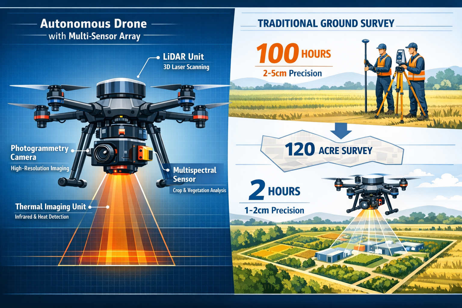
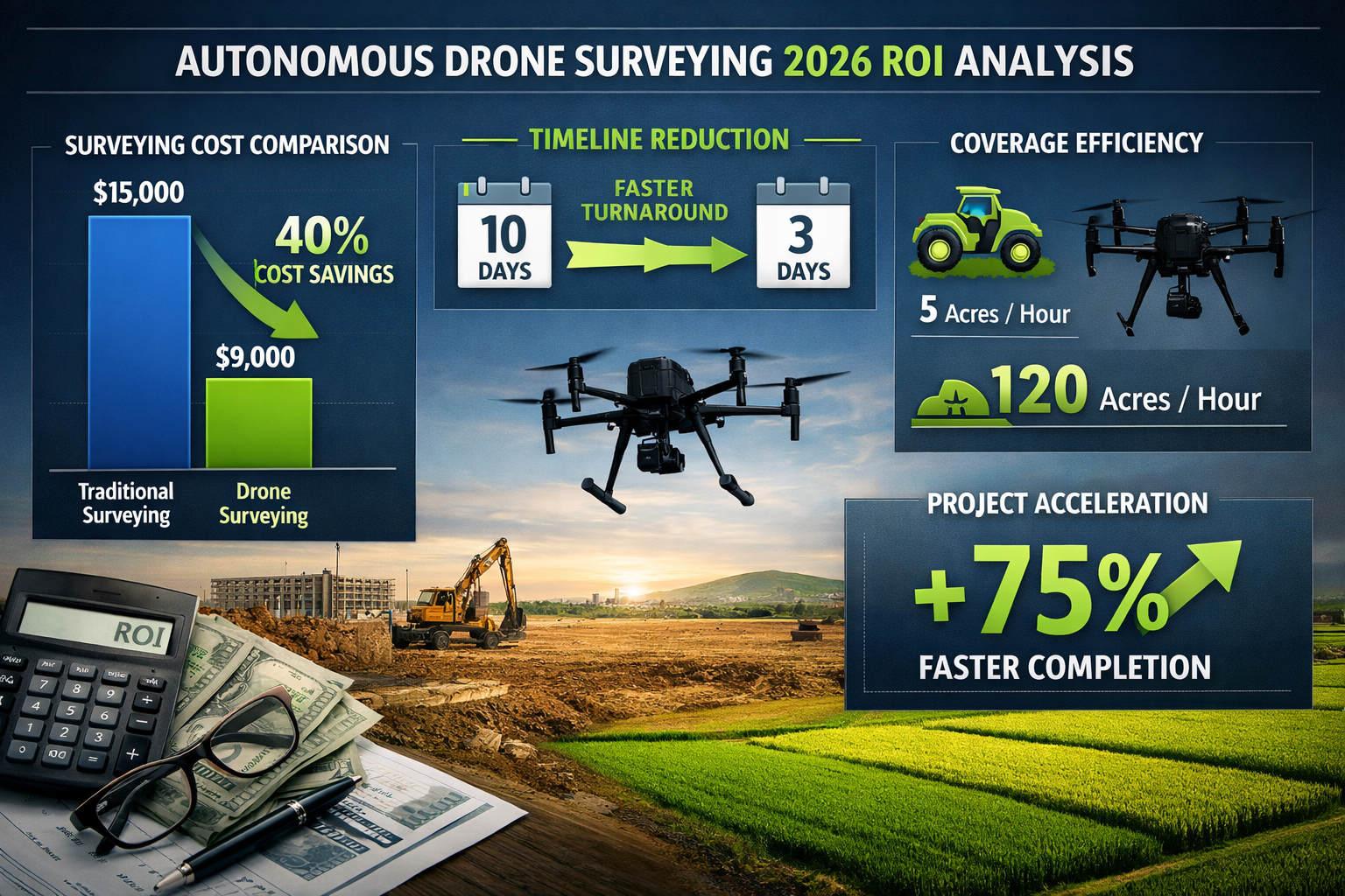
✅ Dramatic Efficiency Gains: Autonomous drones can survey 120 acres per hour compared to just 5 acres per hour with traditional ground methods—a 24-fold increase in coverage[3]
✅ Multi-Sensor Integration: Modern UAV systems synchronize LiDAR, photogrammetry cameras, multispectral sensors, and thermal imaging in single flights, eliminating the need for multiple site visits[1]
✅ Superior Accuracy: Autonomous platforms deliver 1-2 centimeter precision on topographic surveys, surpassing traditional ground methods that typically achieve 2-5 centimeter accuracy[3]
✅ Significant Cost Reduction: Construction sites report 40% cost savings and 40% faster project documentation through autonomous UAV workflows[3]
✅ Rapid Turnaround: Survey turnaround times have decreased from 10 days to 3 days or less for permit-ready deliverables using autonomous drone systems[2]
Understanding Multi-Sensor Integration in Autonomous Drone Systems
The foundation of Autonomous Drones in Property Surveying: Mastering Multi-Sensor Flights for Large-Scale Projects lies in sophisticated sensor fusion technology. Unlike earlier drone surveying approaches that required separate flights for different data types, today's autonomous systems operate with synchronized sensor arrays that capture comprehensive property information simultaneously[1].
The Core Sensor Technologies
Modern autonomous UAV platforms integrate four primary sensor categories:
LiDAR (Light Detection and Ranging) 📡
- Generates precise three-dimensional point clouds
- Penetrates vegetation to capture ground surface data
- Delivers centimeter-level elevation accuracy
- Ideal for topographic mapping and volumetric calculations
Photogrammetry Cameras 📷
- Captures high-resolution RGB imagery
- Creates detailed orthomosaic maps
- Enables visual documentation and feature identification
- Produces accurate measurements from overlapping images
Multispectral Sensors 🌈
- Measures light reflection across multiple wavelengths
- Assesses vegetation health and crop conditions
- Identifies moisture patterns and drainage issues
- Critical for agricultural and environmental applications
Thermal Imaging Units 🌡️
- Detects temperature variations across surfaces
- Identifies heat loss, moisture intrusion, and structural anomalies
- Supports infrastructure inspection and maintenance planning
- Valuable for building envelope assessments
The revolutionary aspect of 2026 technology is that these sensors now work simultaneously and autonomously, with onboard processors coordinating data capture to ensure complete coverage without gaps or redundancy[1]. This integration allows surveyors to gather data that previously required multiple visits, specialized equipment, and different operators—all in a single autonomous flight.
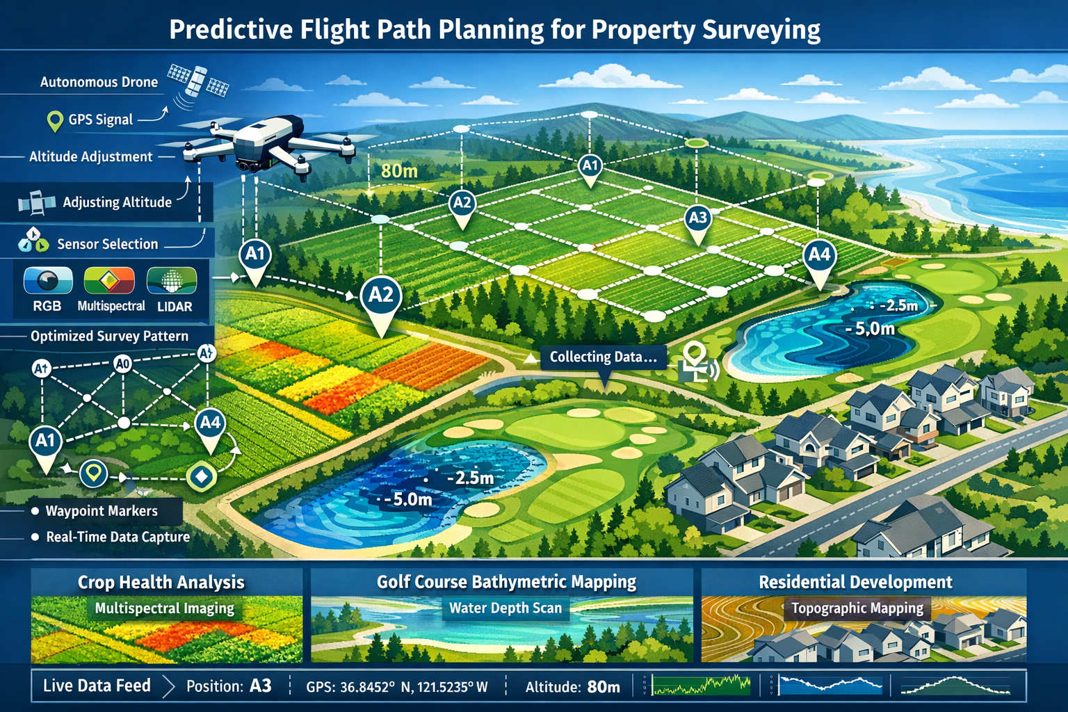
Predictive Flight Path Planning
Autonomous flight capabilities have evolved beyond simple pre-programmed routes. Modern systems employ predictive modeling that automatically adjusts flight parameters based on terrain, project requirements, and environmental conditions[1].
These intelligent systems:
- Analyze terrain elevation to maintain optimal sensor distances
- Adjust flight altitude dynamically for consistent ground sampling distance
- Modify camera angles to ensure proper image overlap
- Select appropriate sensors for different zones within the survey area
- Compensate for wind conditions to maintain stability and data quality
For professionals conducting building surveys or commercial building surveys, this autonomous intelligence means more reliable data collection with minimal operator intervention.
Cost-Benefit Analysis: Autonomous Drones in Property Surveying for 2026 Users
Understanding the financial implications of Autonomous Drones in Property Surveying: Mastering Multi-Sensor Flights for Large-Scale Projects requires examining both direct cost savings and broader efficiency gains that impact project timelines and decision-making.
Direct Cost Comparisons
| Survey Method | 12-Acre Property | 120-Acre Property | Accuracy | Turnaround Time |
|---|---|---|---|---|
| Traditional Ground Survey | 100 hours | 1,000+ hours | 2-5 cm | 10+ days |
| Autonomous Drone Survey | 2 hours | 20 hours | 1-2 cm | 3 days |
| Cost Savings | 98% time reduction | 98% time reduction | Superior | 70% faster |
The numbers speak clearly: a 12-acre property that once required 100 hours of traditional surveying can be completed in as little as 2 hours using autonomous drone technology[5]. This dramatic reduction translates directly to labor cost savings, reduced project delays, and faster decision-making.
Real-World Cost Savings Documentation
Construction sites across Arizona and Nevada have documented 40% cost savings and 40% faster project documentation through autonomous UAV workflows as of 2024[3]. These savings stem from multiple factors:
💰 Reduced Labor Costs
- Fewer field personnel required
- Minimal manual data collection
- Reduced safety equipment and insurance costs
- Lower transportation and accommodation expenses for remote sites
⏱️ Accelerated Project Timelines
- Survey turnaround reduced from 10 days to 3 days or less[2]
- Faster permit application processes
- Earlier identification of design conflicts
- Reduced holding costs for development projects
📊 Enhanced Data Quality
- Superior 1-2 centimeter accuracy reduces rework[3]
- Comprehensive multi-sensor data supports better decisions
- Reduced risk of costly survey errors
- Better documentation for property valuation purposes
Equipment Investment Considerations
The DJI Matrice 350 RTK, a leading autonomous drone platform for surveying, delivers up to 55 minutes of flight time while supporting multi-sensor payloads[3]. While the initial equipment investment ranges from $15,000 to $50,000 depending on sensor configuration, the return on investment typically occurs within 6-12 months for active surveying operations.
For property owners requiring occasional surveys rather than continuous operations, Drone as a Service (DaaS) models have emerged as cost-effective alternatives. ZenaTech's recent expansion into homebuilding surveying demonstrates how DaaS providers deliver professional-grade autonomous surveying without requiring clients to purchase and maintain equipment[2].
Long-Term Value Proposition
Beyond immediate cost savings, autonomous multi-sensor drones provide particular value for clients with large agricultural, commercial, or development-scale properties[1]. The comprehensive data captured enables:
- Better-informed development decisions through detailed topographic analysis
- Ongoing monitoring of construction progress and site changes
- Vegetation health tracking for agricultural properties
- Infrastructure maintenance planning through thermal and multispectral analysis
- Enhanced documentation for project management purposes
For professionals conducting structural surveys, the ability to capture detailed roof conditions, drainage patterns, and site context through autonomous flights adds significant value to traditional inspection methods.
Applications Across Agriculture and Development Sectors
Autonomous Drones in Property Surveying: Mastering Multi-Sensor Flights for Large-Scale Projects has found particularly strong adoption in two primary sectors: agriculture and property development. Each sector leverages the multi-sensor capabilities differently, but both benefit from the efficiency and precision these systems deliver.
Agricultural Applications
The agricultural sector has embraced autonomous drone surveying for its ability to monitor large properties efficiently while providing actionable insights through multispectral and thermal imaging.
Crop Health Monitoring 🌾
- Multispectral sensors identify stressed vegetation before visible symptoms appear
- NDVI (Normalized Difference Vegetation Index) mapping guides targeted interventions
- Early disease detection minimizes crop losses
- Irrigation efficiency assessments reduce water waste
Topographic Analysis for Drainage Planning
- LiDAR penetrates crop canopy to map actual ground surface
- Identifies low spots prone to waterlogging
- Guides drainage system design and tile placement
- Optimizes field leveling for improved productivity
Precision Agriculture Support
- Variable rate application mapping for fertilizers and pesticides
- Yield prediction through biomass estimation
- Soil moisture pattern identification
- Historical change detection across growing seasons
ZenaTech's February 2026 expansion into golf course surveying demonstrates the versatility of autonomous multi-sensor systems. The company completed surveys for five championship-level courses, providing topographic, bathymetric, and vegetation health services across its seven Florida DaaS locations[4]. Golf courses present unique surveying challenges—combining manicured turf, water features, elevation changes, and vegetation management—that benefit tremendously from integrated multi-sensor approaches.
Development and Construction Applications
Property developers and construction firms leverage autonomous drones throughout the entire project lifecycle, from initial site assessment through final as-built documentation.
Site Selection and Due Diligence 🏗️
- Comprehensive topographic mapping for feasibility analysis
- Volumetric calculations for cut-and-fill estimates
- Drainage pattern identification
- Environmental feature documentation
- Integration with property certification requirements
Design Phase Support
- Accurate base mapping for architectural and engineering design
- 3D terrain models for visualization
- Utility corridor planning
- Access road design optimization
Construction Monitoring
- Regular progress documentation
- Earthwork volume verification
- Quality control through comparison to design models
- Safety monitoring and site security
Final Documentation
- As-built surveys for permitting closeout
- Homebuyer survey support through comprehensive site documentation
- Warranty baseline documentation
- Handover packages for property management
The integration of autonomous drones with standardized processes has enabled ZenaTech's Drone as a Service workflow to reduce permit-ready survey turnaround from typically 10 days to 3 days or less for homebuilders nationwide[2]. This acceleration comes from the combination of autonomous flight efficiency, multi-sensor data capture, and streamlined processing workflows.
Infrastructure and Specialized Applications
Beyond agriculture and development, autonomous multi-sensor drones serve specialized surveying needs:
Energy Sector ⚡
- Solar farm site assessment and monitoring
- Wind turbine inspection and blade analysis
- Transmission corridor mapping
- Thermal inspection of electrical infrastructure
Mining and Quarrying ⛏️
- Stockpile volume calculations
- Pit progression monitoring
- Haul road planning and maintenance
- Reclamation verification
Environmental Monitoring 🌍
- Wetland delineation and monitoring
- Erosion assessment and tracking
- Vegetation encroachment identification
- Wildlife habitat mapping
The versatility of autonomous multi-sensor systems means that professionals conducting specialist defect surveys can supplement traditional inspection methods with comprehensive aerial data that provides context and identifies issues not visible from ground level.
Technical Capabilities and Performance Specifications
Understanding the technical specifications behind Autonomous Drones in Property Surveying: Mastering Multi-Sensor Flights for Large-Scale Projects helps users select appropriate systems and set realistic expectations for survey deliverables.
Coverage and Efficiency Metrics
The dramatic efficiency advantage of autonomous drones becomes clear when examining coverage rates:
Coverage Comparison:
- Traditional Ground Survey: 5 acres per hour
- Autonomous Drone Survey: 120 acres per hour
- Efficiency Gain: 24-fold increase[3]
This 24-fold improvement stems from several factors:
- Continuous Operation: Drones maintain consistent survey speed without fatigue
- Direct Line-of-Sight: Aerial platforms avoid terrain obstacles that slow ground crews
- Automated Data Capture: No manual measurements or setup time at each point
- Multi-Sensor Efficiency: Simultaneous data collection eliminates return visits
For large-scale projects, this efficiency translates to survey completion in days rather than weeks, enabling faster project advancement and reduced holding costs.
Accuracy and Precision Standards
Centimeter-level precision has become the standard for autonomous UAV topographic surveys, with systems routinely achieving 1-2 centimeter accuracy[3]. This precision surpasses traditional ground methods that typically deliver 2-5 centimeter accuracy while requiring significantly more time and effort.
Several technologies enable this precision:
RTK (Real-Time Kinematic) GPS 🛰️
- Corrects GPS signals using ground-based reference stations
- Achieves centimeter-level position accuracy
- Enables direct georeferencing without extensive ground control
- Reduces post-processing time and field work
Ground Control Points (GCPs)
- Surveyed reference markers for additional accuracy verification
- Supports projects requiring sub-centimeter precision
- Provides quality assurance for critical measurements
- Enables accuracy certification for regulatory compliance
PPK (Post-Processed Kinematic)
- Alternative to RTK for areas without real-time correction signals
- Processes GPS data after flight using base station logs
- Achieves similar accuracy to RTK
- Useful for remote locations
Flight Duration and Area Coverage
Extended flight capability directly impacts project efficiency and operational costs. The DJI Matrice 350 RTK autonomous drone delivers up to 55 minutes of flight time while supporting multi-sensor payloads[3], enabling comprehensive large-area mapping in single operations.
Practical flight planning considerations:
- Effective Survey Time: 40-45 minutes per battery (allowing safety margins)
- Area per Flight: 40-80 acres depending on required resolution and overlap
- Daily Capacity: 200-400 acres with multiple battery sets
- Weather Constraints: Wind speeds below 25 mph, no precipitation, adequate visibility
For professionals managing monitoring surveys over extended periods, the ability to complete comprehensive baseline surveys quickly and repeat them consistently provides valuable change detection capabilities.
Data Processing and Deliverable Formats
Autonomous multi-sensor flights generate substantial data volumes that require specialized processing:
Typical Data Outputs:
📊 Photogrammetry Products
- Orthomosaic maps (georeferenced aerial imagery)
- Digital Surface Models (DSM)
- Digital Terrain Models (DTM)
- 3D mesh models
- Contour maps
📊 LiDAR Products
- Point cloud datasets
- Classified ground points
- Vegetation models
- Volumetric calculations
- Cross-section profiles
📊 Multispectral Products
- NDVI vegetation health maps
- Crop stress identification
- Moisture pattern analysis
- Historical comparison datasets
📊 Thermal Products
- Temperature distribution maps
- Anomaly identification
- Heat loss visualization
- Moisture intrusion detection
Modern processing software automates much of the workflow, with cloud-based platforms enabling same-day or next-day deliverable production. This rapid turnaround supports the compressed timelines that make autonomous drone surveying particularly valuable for time-sensitive projects.
Regulatory Compliance and Industry Standards
Operating Autonomous Drones in Property Surveying: Mastering Multi-Sensor Flights for Large-Scale Projects requires compliance with aviation regulations, surveying standards, and data privacy requirements.
Aviation Regulations (2026 Framework)
Commercial Drone Operations in the United States operate under FAA Part 107 regulations, with specific provisions for autonomous operations:
✈️ Operator Requirements
- Remote Pilot Certificate with small UAS rating
- Current knowledge of airspace restrictions
- Understanding of autonomous system limitations
- Emergency override capabilities
✈️ Operational Limitations
- Operations within visual line of sight (VLOS) or approved beyond visual line of sight (BVLOS)
- Maximum altitude 400 feet above ground level (unless near structures)
- Daylight operations (or with appropriate waiver)
- Minimum visibility and cloud clearance requirements
✈️ Autonomous-Specific Provisions
- Demonstrated system reliability and redundancy
- Emergency return-to-home functionality
- Geofencing for restricted airspace
- Flight logging and data recording
BVLOS (Beyond Visual Line of Sight) waivers have become more accessible in 2026 for established operators with proven safety records, enabling truly large-scale autonomous surveying operations.
Professional Surveying Standards
While autonomous drones provide efficient data capture, professional surveying standards still apply to deliverables:
ALTA/NSPS Land Title Surveys
- Require licensed surveyor oversight
- Mandate specific accuracy standards
- Include boundary determination (not purely aerial)
- Combine drone data with traditional boundary surveying
Topographic Survey Standards
- Accuracy specifications based on project requirements
- Quality control procedures and verification
- Professional certification of deliverables
- Compliance with local surveying regulations
For projects requiring formal surveying certification, autonomous drone data typically supplements rather than replaces licensed surveyor involvement. However, the efficiency gains in data collection allow surveyors to focus expertise on analysis, boundary determination, and professional certification rather than time-consuming field measurements.
Data Privacy and Security Considerations
Multi-sensor drone flights capture detailed information about properties and surrounding areas, raising privacy and security considerations:
🔒 Privacy Protections
- Notification of adjacent property owners when appropriate
- Compliance with local privacy ordinances
- Secure data storage and transmission
- Limited data retention policies
🔒 Security Measures
- Encrypted data transmission
- Access controls for sensitive project information
- Compliance with client confidentiality requirements
- Secure cloud storage with redundancy
Professional surveying firms implementing autonomous drone programs typically establish clear data handling protocols that address these concerns while maximizing the technology's benefits.
Selecting and Implementing Autonomous Drone Systems
Organizations considering adoption of Autonomous Drones in Property Surveying: Mastering Multi-Sensor Flights for Large-Scale Projects face important decisions about equipment selection, training, and operational integration.
Equipment Selection Criteria
Platform Considerations 🚁
When selecting autonomous drone platforms for surveying applications, key factors include:
- Payload Capacity: Ability to carry multiple sensors simultaneously
- Flight Duration: Extended battery life for large-area coverage
- RTK/PPK Capability: Integrated precision positioning
- Weather Resistance: Wind tolerance and environmental protection
- Redundancy Systems: Multiple GPS, IMU, and safety features
- Automation Level: Sophisticated flight planning and execution
- Support and Service: Manufacturer reliability and parts availability
The DJI Matrice 350 RTK has emerged as an industry standard for professional surveying, offering the balance of capabilities, reliability, and support that surveying operations require[3].
Sensor Selection
Multi-sensor integration requires careful consideration of project requirements:
| Sensor Type | Primary Applications | Cost Range | Data Volume |
|---|---|---|---|
| RGB Camera | Visual documentation, photogrammetry | $1,000-$5,000 | Moderate |
| LiDAR | Topographic mapping, vegetation penetration | $20,000-$100,000 | Very High |
| Multispectral | Agriculture, vegetation health | $5,000-$15,000 | Moderate |
| Thermal | Infrastructure inspection, moisture detection | $3,000-$10,000 | Low |
Many organizations begin with high-quality RGB photogrammetry systems and add specialized sensors as project demands and budgets allow.
Build vs. Buy vs. Service Decision
Three primary approaches exist for accessing autonomous drone surveying capabilities:
Option 1: In-House Program 🏢
- Best For: Organizations with consistent surveying needs
- Investment: $30,000-$100,000+ for equipment, training, software
- Advantages: Complete control, data security, immediate availability
- Challenges: Maintenance, training, regulatory compliance, utilization
Option 2: Drone as a Service (DaaS) 📱
- Best For: Occasional or variable surveying needs
- Investment: Pay-per-project or subscription models
- Advantages: No equipment investment, professional expertise, scalability
- Challenges: Less control, scheduling dependencies, recurring costs
Option 3: Hybrid Approach 🔄
- Best For: Growing programs with seasonal variation
- Investment: Basic equipment plus service partnerships
- Advantages: Flexibility, capacity management, specialized capabilities
- Challenges: Coordination complexity, potential redundancy
ZenaTech's acquisition of Cardinal Civil Resources in 2025 and integration into its Drone as a Service network demonstrates the maturation of DaaS models, with established relationships serving major homebuilders like Ryan Homes[2]. This professional service approach enables access to cutting-edge autonomous multi-sensor capabilities without the full burden of program development.
Training and Skill Development
Successful implementation requires investment in personnel capabilities:
Core Competencies 📚
- FAA Part 107 Remote Pilot certification
- Flight planning and mission design
- Sensor operation and calibration
- Data processing software proficiency
- Quality control and verification procedures
- Safety protocols and emergency procedures
Advanced Skills
- Autonomous system programming
- Multi-sensor data fusion
- Surveying principles and standards
- GIS and CAD integration
- Regulatory compliance management
Many equipment manufacturers and industry associations offer training programs specifically designed for surveying professionals transitioning to autonomous drone operations.
Integration with Existing Workflows
Successful adoption requires thoughtful integration with established surveying and project management processes:
Workflow Integration Points 🔗
- Project intake and scope definition
- Flight planning and field logistics
- Data capture and quality verification
- Processing and deliverable production
- Client review and revision cycles
- Final deliverable and archiving
For firms offering homebuyer surveys or Level 2 homebuyer surveys, autonomous drone data can supplement traditional inspection methods by providing comprehensive roof and site context documentation that enhances report quality and client value.
Future Trends and Emerging Capabilities
The trajectory of Autonomous Drones in Property Surveying: Mastering Multi-Sensor Flights for Large-Scale Projects points toward continued advancement in automation, sensor capabilities, and data intelligence.
Artificial Intelligence and Machine Learning Integration
AI-powered capabilities emerging in 2026 include:
🤖 Automated Feature Extraction
- Automatic identification of buildings, roads, utilities, and vegetation
- Classification of land cover types
- Detection of changes between survey dates
- Anomaly identification and flagging
🤖 Intelligent Flight Planning
- Machine learning optimization of flight paths
- Adaptive sensor selection based on terrain and objectives
- Weather prediction and optimal timing recommendations
- Battery management and multi-flight coordination
🤖 Quality Assurance Automation
- Real-time gap detection during flight
- Automatic image quality assessment
- Coverage verification and re-flight triggering
- Accuracy prediction and validation
Swarm Technology and Coordinated Operations
Multi-drone coordination represents the next frontier in large-scale surveying:
- Simultaneous Coverage: Multiple drones surveying different zones concurrently
- Specialized Roles: Different drones carrying different sensor suites
- Continuous Operations: Battery swap coordination for uninterrupted coverage
- Redundancy: Backup systems for critical projects
Early implementations of swarm technology have demonstrated the potential to survey thousands of acres in single days—capabilities particularly valuable for large agricultural operations, mining sites, and infrastructure corridors.
Enhanced Sensor Technologies
Next-generation sensors under development include:
📡 Hyperspectral Imaging
- Hundreds of spectral bands versus multispectral's 5-10 bands
- Enhanced material identification and classification
- Detailed vegetation stress analysis
- Mineral and soil composition mapping
📡 Advanced LiDAR
- Higher point density for finer detail
- Improved vegetation penetration
- Bathymetric capabilities for underwater mapping
- Reduced size and weight for smaller platforms
📡 Gas Detection Sensors
- Methane leak detection for energy infrastructure
- Air quality monitoring
- Environmental compliance verification
- Safety hazard identification
Regulatory Evolution
The regulatory framework continues evolving to accommodate autonomous capabilities:
Anticipated Developments ⚖️
- Expanded BVLOS approvals for proven operators
- Automated airspace authorization systems
- Integration with air traffic management
- Standardized autonomous system certification
These regulatory advances will further unlock the efficiency potential of autonomous multi-sensor surveying systems.
Market Growth and Adoption
The global drone services market's projected growth to exceed $30 billion by 2026[4] reflects strong adoption across multiple sectors. Survey and mapping applications represent a significant portion of this growth, driven by:
- Construction industry digital transformation
- Precision agriculture expansion
- Infrastructure maintenance requirements
- Environmental monitoring mandates
- Insurance and risk assessment applications
This market expansion creates opportunities for surveying professionals to differentiate services, improve efficiency, and access new market segments through autonomous drone capabilities.
Conclusion: Embracing the Autonomous Multi-Sensor Revolution
Autonomous Drones in Property Surveying: Mastering Multi-Sensor Flights for Large-Scale Projects represents a fundamental transformation in how surveying professionals capture and deliver property data. The combination of self-adjusting flight systems, synchronized multi-sensor arrays, and intelligent data processing has created capabilities that were simply unavailable a decade ago[1].
The evidence supporting adoption is compelling:
✅ 24-fold efficiency gains over traditional methods[3]
✅ Superior accuracy at 1-2 centimeter precision[3]
✅ 40% cost savings with 40% faster documentation[3]
✅ 70% reduction in turnaround times[2]
✅ Comprehensive data from single flights versus multiple visits[1]
For property owners, developers, agricultural operators, and surveying professionals, these advantages translate directly to better decisions, faster projects, and reduced costs.
Actionable Next Steps
For Property Owners and Developers 🏘️
- Assess Current Surveying Needs: Identify upcoming projects that could benefit from autonomous drone surveying
- Request Comparative Proposals: Obtain quotes for both traditional and drone-based approaches
- Evaluate DaaS Providers: Research established Drone as a Service providers with proven track records
- Start with Pilot Projects: Test autonomous drone surveying on non-critical projects before full adoption
- Integrate with Professional Services: Combine drone data with traditional property valuation and structural survey services
For Surveying Professionals 📐
- Evaluate Business Case: Analyze project mix to determine in-house versus service partnership approach
- Pursue Training: Obtain FAA Part 107 certification and specialized drone surveying training
- Start Equipment Research: Identify platforms and sensors aligned with primary service offerings
- Develop Partnerships: Establish relationships with DaaS providers for specialized or overflow capacity
- Update Service Offerings: Communicate enhanced capabilities to existing and prospective clients
- Integrate Workflows: Develop processes that combine autonomous drone data with traditional surveying expertise
For Agricultural Operations 🌾
- Define Monitoring Objectives: Identify specific crop health, drainage, or management challenges
- Establish Baseline Surveys: Conduct comprehensive multi-sensor surveys to establish reference data
- Implement Regular Monitoring: Schedule periodic flights throughout growing seasons
- Integrate with Management Systems: Connect drone data with precision agriculture platforms
- Track ROI: Document yield improvements, input savings, and problem prevention
The Competitive Advantage
Organizations that master autonomous multi-sensor drone surveying gain significant competitive advantages:
- Speed to Market: Faster surveys enable quicker development decisions and project advancement
- Data-Driven Decisions: Comprehensive multi-sensor data supports better planning and risk management
- Cost Leadership: Efficiency gains translate to competitive pricing or improved margins
- Service Differentiation: Advanced capabilities attract clients seeking cutting-edge solutions
- Scalability: Autonomous systems enable growth without proportional staffing increases
The technology has matured beyond early-adopter status. With proven platforms like the DJI Matrice 350 RTK[3], established service providers like ZenaTech's expanding DaaS network[2][4], and documented cost savings across multiple sectors[3], the question is no longer whether autonomous multi-sensor drones deliver value—it's how quickly organizations can effectively implement these capabilities.
A Transformed Industry Landscape
The surveying industry of 2026 looks dramatically different from just five years ago. What once required weeks of field work, multiple specialized teams, and substantial manual processing now occurs in days through autonomous flights and automated workflows. The clarity and detail available through synchronized LiDAR, photogrammetry, multispectral, and thermal sensors provides insights previously unavailable at any cost[1].
For professionals conducting subsidence surveys, damp surveys, or specific defect reports, autonomous drone data provides valuable context and documentation that enhances traditional inspection methods.
The future belongs to organizations that embrace these capabilities while maintaining the professional expertise and judgment that technology enhances rather than replaces. Autonomous Drones in Property Surveying: Mastering Multi-Sensor Flights for Large-Scale Projects is not about replacing surveyors—it's about empowering them with tools that multiply their effectiveness, expand their capabilities, and deliver unprecedented value to clients.
The revolution is here. The question is: are you ready to master it?
References
[1] Future Land Surveying 2026 – https://haller-blanchard.com/future-land-surveying-2026/
[2] Zenatech S Drone As A Service Expands Builder Services Capability Delivering Drone Driven Speed And Precision To Surveying For Homebuilders – https://markets.businessinsider.com/news/currencies/zenatech-s-drone-as-a-service-expands-builder-services-capability-delivering-drone-driven-speed-and-precision-to-surveying-for-homebuilders-1035808701
[3] Uav Construction – https://www.extremeaerialproductions.com/post/uav-construction
[4] Drone Survey Operations Drive Scalable Growth In Drones As A Service Daas – https://www.globenewswire.com/news-release/2026/02/05/3233129/0/en/Drone-Survey-Operations-Drive-Scalable-Growth-in-Drones-as-a-Service-DaaS.html
[5] Drones In Construction – https://uavcoach.com/drones-in-construction/