The surveying industry stands at a transformative crossroads in 2026, where autonomous drones have fundamentally changed how professionals capture, analyze, and deliver land data. Gone are the days when surveying large estates, agricultural lands, or development sites required weeks of manual fieldwork with traditional equipment. Today, Autonomous Drones in Land Surveying: Capturing Large Properties with Single Flights in 2026 represents not just technological advancement, but a complete paradigm shift in efficiency, accuracy, and cost-effectiveness.
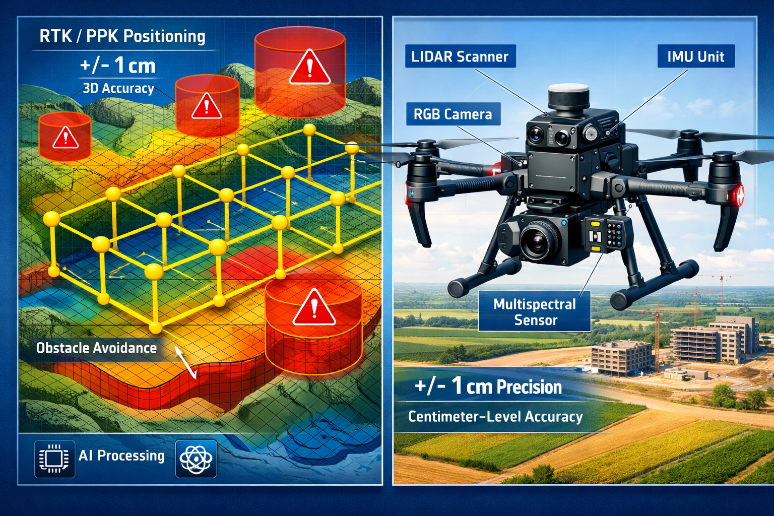
Modern autonomous drones equipped with advanced sensors, artificial intelligence, and precision positioning systems can now survey hundreds of acres in a single flight—delivering survey-grade data that rivals traditional methods while slashing time and labor costs. These sophisticated unmanned aerial vehicles (UAVs) automatically generate optimal flight paths, adjust altitude based on terrain variations, avoid obstacles in real-time, and return safely without constant manual intervention[1]. The integration of LiDAR technology, RTK/PPK GNSS systems, and AI-powered data processing has transformed what was once a futuristic concept into standard professional practice.
Key Takeaways
✅ Autonomous drones can survey hundreds of acres in hours rather than the days or weeks required by traditional surveying methods, delivering centimeter-level accuracy through RTK/PPK GNSS systems[1][2]
✅ Multi-sensor payloads combining LiDAR, RGB cameras, and multispectral sensors enable comprehensive data capture for diverse applications from agriculture to development planning[2]
✅ Drone-in-a-box systems enable continuous monitoring without on-site pilots, revolutionizing infrastructure inspection and scheduled surveys through fully automated operations[2]
✅ Cost reductions of 40-60% compared to traditional methods are now standard, with additional savings from reduced ground control point requirements and faster data processing[2]
✅ AI-powered cloud processing automates workflows that previously required days or weeks of manual work, delivering CAD-ready files and actionable insights within hours of flight completion[1][2]
Understanding Autonomous Drone Technology in Modern Land Surveying
The evolution of drone technology has accelerated dramatically over the past few years, but 2026 marks a watershed moment where autonomous capabilities have become the industry standard rather than an experimental feature. Understanding what makes these systems truly autonomous—and how they differ from earlier drone-assisted surveying—is essential for appreciating their transformative impact.
What Makes a Drone Truly Autonomous?
True autonomy in surveying drones extends far beyond simple waypoint navigation. Modern autonomous systems incorporate multiple layers of intelligence and decision-making capability that fundamentally distinguish them from their predecessors.
Predictive flight path generation represents one of the most significant advances. Today's drones don't simply follow pre-programmed routes; they analyze terrain data, weather conditions, and survey objectives to generate optimal flight patterns that maximize data quality while minimizing flight time[1]. The system considers factors like sun angle, shadow patterns, wind conditions, and terrain complexity to determine the ideal altitude, overlap percentages, and camera angles.
Real-time obstacle detection and avoidance ensures safe operations even in complex environments. Advanced sensor arrays including forward-facing cameras, ultrasonic sensors, and radar systems create a comprehensive awareness bubble around the aircraft. When unexpected obstacles appear—whether trees, power lines, buildings, or other aircraft—the drone automatically adjusts its flight path while maintaining survey accuracy[1].
Adaptive altitude control allows drones to maintain consistent ground sampling distance (GSD) even over dramatically varying terrain. Rather than flying at a fixed altitude above the launch point, autonomous systems continuously adjust their height to maintain optimal distance from the ground surface, ensuring uniform data quality across rolling hills, valleys, and elevation changes.
Multi-Sensor Integration for Comprehensive Data Capture
The power of Autonomous Drones in Land Surveying: Capturing Large Properties with Single Flights in 2026 lies not just in autonomous flight capabilities, but in the sophisticated sensor payloads these platforms carry. Modern surveying drones integrate multiple complementary sensors that capture different types of data simultaneously.
LiDAR (Light Detection and Ranging) systems have become mainstream in 2026, with costs dropping dramatically from previous years[2]. These sensors emit rapid laser pulses—often exceeding 1 million pulses per second—and measure the time it takes for each pulse to return. The result is an incredibly detailed point cloud representing the three-dimensional structure of the surveyed area. Modern LiDAR systems feature:
- Improved penetration capabilities that can map ground surfaces even under dense vegetation canopy
- Enhanced IMU (Inertial Measurement Unit) integration for superior accuracy during dynamic flight
- Multi-return processing that captures both canopy structure and bare earth elevation in forested areas
- Faster pulse repetition rates enabling higher point densities and better feature detection[2]
RGB cameras capture high-resolution visual imagery that provides context and detail complementing the LiDAR data. These aren't simple consumer cameras; professional surveying drones employ medium-format cameras with large sensors, global shutters to eliminate rolling shutter distortion, and precisely calibrated lenses that minimize geometric distortion.
Multispectral and thermal sensors expand surveying capabilities beyond traditional topographic mapping. These sensors capture data across multiple wavelengths, enabling applications like:
- Vegetation health analysis for agricultural monitoring
- Moisture detection for drainage planning and irrigation optimization
- Thermal mapping for building envelope analysis and energy audits
- Crop stress identification before visible symptoms appear
When integrated with building surveys and traditional property assessment methods, this multi-sensor data provides unprecedented comprehensive property analysis.
RTK/PPK GNSS: Achieving Centimeter-Level Accuracy
Precision positioning separates professional surveying drones from recreational or basic commercial systems. Real-Time Kinematic (RTK) and Post-Processed Kinematic (PPK) GNSS technology delivers the centimeter-level accuracy that meets professional survey-grade standards[1][2].
RTK systems receive correction data from a base station in real-time during the flight. The base station, positioned at a known surveyed point, compares its calculated position with its actual known position and transmits correction data to the drone. This enables the drone to determine its position with remarkable precision—typically within 1-2 centimeters horizontally and 2-3 centimeters vertically.
PPK technology offers similar accuracy but processes the correction data after the flight. The drone logs raw GNSS data during flight, which is later combined with base station data during post-processing. PPK provides several advantages:
- Greater reliability in areas with radio interference or limited real-time communication
- Flexibility to use multiple base station sources for correction data
- Improved accuracy through more sophisticated processing algorithms
- Reduced dependency on maintaining constant radio links during flight
This positioning precision has dramatically reduced ground control point (GCP) requirements. Traditional photogrammetric surveys required numerous precisely surveyed ground markers throughout the survey area. Modern RTK/PPK workflows often require only a handful of checkpoints for quality verification, significantly reducing field time and costs—especially valuable for remote locations and linear infrastructure projects like pipelines or transmission corridors[2].
The Economics of Autonomous Drones in Land Surveying: Capturing Large Properties with Single Flights in 2026
The financial case for adopting autonomous drone technology in land surveying has never been more compelling. While initial equipment investment remains substantial, the efficiency gains, labor savings, and expanded service capabilities deliver return on investment that traditional methods simply cannot match.
Direct Cost Comparisons: Traditional vs. Autonomous Methods
Understanding the true cost differential requires examining both direct expenses and hidden costs across the entire surveying workflow. When professionals evaluate different types of survey comparison, the autonomous drone advantage becomes clear.
Traditional surveying costs for large properties typically include:
| Cost Category | Traditional Method | Autonomous Drone Method |
|---|---|---|
| Equipment | Total station, GPS receivers, levels ($30,000-$80,000) | Autonomous drone system with sensors ($40,000-$120,000) |
| Field Crew | 2-4 surveyors for multiple days | 1 operator for hours |
| Labor Costs | $150-$300/hour for crew | $75-$150/hour for single operator |
| Time Required | 3-10 days for 100 acres | 2-6 hours flight + processing |
| Ground Access | Requires physical access to entire property | Minimal ground access needed |
| Data Processing | Manual CAD drafting (days to weeks) | Automated processing (hours) |
| Total Cost (100 acres) | $15,000-$35,000 | $6,000-$14,000 |
These figures demonstrate cost reductions of 40-60% for typical large property surveys[2]. The savings become even more dramatic for difficult-to-access terrain, heavily vegetated areas, or properties with access restrictions.
Hidden Cost Advantages
Beyond direct expense comparisons, autonomous drone surveying delivers additional economic benefits that traditional methods cannot match:
Reduced safety risks translate to lower insurance costs and eliminated liability exposure. Surveyors no longer need to work in traffic, on steep slopes, or in other hazardous conditions. The drone operator remains in a safe location while the autonomous system handles dangerous data collection.
Weather flexibility reduces scheduling delays and project timeline uncertainty. While traditional crews might lose entire days to weather conditions, drone operations can often proceed in marginal conditions or complete surveys during brief weather windows. Modern autonomous systems can even pause flights when conditions deteriorate and automatically resume when conditions improve.
Minimal property disruption eliminates costs associated with crop damage, livestock management, or business interruption. A traditional survey crew trampling through agricultural fields or construction sites creates tangible costs and liability concerns. Aerial surveying eliminates these issues entirely.
Expanded service radius allows surveying firms to efficiently serve clients across wider geographic areas without establishing satellite offices or incurring extensive travel costs. A single operator can transport a complete autonomous drone system in a vehicle and deploy it anywhere.
Revenue Opportunities and Service Expansion
The efficiency gains from autonomous drone technology don't just reduce costs—they create opportunities for expanded services and new revenue streams that weren't economically viable with traditional methods.
Volume-based pricing models become attractive when survey costs drop dramatically. Firms can offer competitive rates for large properties while maintaining healthy margins, winning projects that would have been unprofitable using traditional methods.
Recurring monitoring contracts leverage autonomous drone-in-a-box systems that can conduct scheduled surveys without on-site personnel[2]. Agricultural clients might contract for monthly crop health monitoring. Development projects benefit from weekly progress documentation. Infrastructure owners receive quarterly condition assessments. These recurring revenue streams provide business stability and predictable cash flow.
Multi-disciplinary data packages combine topographic surveying with specialized analysis. A single drone flight can capture data supporting:
- Traditional boundary and topographic surveys
- Volumetric calculations for earthwork planning
- Vegetation analysis for environmental assessments
- Thermal imaging for drainage and moisture analysis
- Progress documentation for construction management
This comprehensive data collection, when integrated with services like RICS commercial building surveys, provides clients with holistic property intelligence that commands premium pricing.
Applications Driving Autonomous Drone Adoption in 2026
The versatility of Autonomous Drones in Land Surveying: Capturing Large Properties with Single Flights in 2026 extends across numerous industries and applications. Understanding these use cases illustrates why adoption has accelerated so dramatically.
Agricultural Land Management and Precision Farming
Agriculture represents one of the largest and fastest-growing markets for autonomous drone surveying. Modern farming operations demand data-driven decision-making, and autonomous drones deliver the precise, timely information farmers need.
Topographic surveys for drainage planning and irrigation design require accurate elevation data across entire farms—often thousands of acres. Autonomous drones equipped with LiDAR can map these vast areas in single flights, identifying subtle elevation changes that affect water flow. The resulting digital elevation models (DEMs) enable engineers to design optimal drainage systems, plan irrigation infrastructure, and identify areas prone to flooding or poor drainage[1].
Crop health monitoring through multispectral imaging reveals plant stress, nutrient deficiencies, and disease outbreaks before they become visible to the human eye. Autonomous drones flying regular monitoring missions create temporal datasets that track crop development throughout the growing season. Farmers use this data to:
- Apply fertilizers and pesticides precisely where needed (reducing costs and environmental impact)
- Identify irrigation system malfunctions quickly
- Estimate yields before harvest
- Document crop conditions for insurance claims
Field boundary documentation for precision agriculture systems requires accurate mapping of field edges, obstacles, and management zones. Autonomous drones create detailed orthomosaic maps that serve as base layers for precision agriculture equipment, ensuring accurate application of inputs and optimal equipment operation.
The ability to survey large agricultural properties in single autonomous flights—without requiring the farmer or surveyor to physically traverse muddy fields or growing crops—has made drone surveying indispensable for modern agricultural operations.
Real Estate Development and Site Planning
Development projects from residential subdivisions to commercial complexes rely on accurate site data throughout the project lifecycle. Autonomous drones have become essential tools for developers, engineers, and planners.
Initial site assessment traditionally required extensive field surveys before development feasibility could be determined. Today, autonomous drones can survey potential development sites quickly and economically, delivering comprehensive topographic data that informs preliminary planning. Developers can evaluate multiple sites rapidly, understanding grading requirements, drainage challenges, and infrastructure needs before committing to expensive land acquisitions.
Design-phase surveying provides the detailed topographic data engineers need for site design. High-resolution DEMs and digital surface models (DSMs) enable accurate grading plans, stormwater management design, and infrastructure layout. The data integrates seamlessly with CAD and BIM (Building Information Modeling) software, streamlining the design workflow[1].
Construction monitoring through regular autonomous flights documents progress, verifies contractor work, and provides stakeholders with visual updates. Volumetric analysis calculates earthwork quantities for payment verification. Time-series datasets create compelling visual records of project development.
As-built documentation captures final site conditions for record-keeping and facility management. The detailed 3D models become valuable assets for property management, future renovation planning, and building operations.
When combined with traditional RICS Building Surveys Level 3 assessments, autonomous drone data provides comprehensive property intelligence for development projects.
Infrastructure Inspection and Asset Management
Linear infrastructure—pipelines, transmission lines, railways, highways—presents unique surveying challenges that autonomous drones are uniquely positioned to address. These assets often span hundreds of miles through varied and difficult terrain.
Corridor mapping for pipeline and transmission line projects requires detailed topographic data along narrow corridors that may traverse mountains, forests, wetlands, and developed areas. Autonomous drones can survey these corridors far more efficiently than traditional methods, which would require extensive ground access and vegetation clearing. The reduced ground control point requirements of RTK/PPK systems are particularly valuable for these linear projects[2].
Condition assessment through regular autonomous inspections identifies maintenance needs, vegetation encroachment, and potential hazards. Drone-in-a-box systems deployed at strategic locations along infrastructure corridors can conduct scheduled inspections automatically, uploading data to cloud platforms for AI-powered analysis[2]. Anomalies trigger alerts for human review, enabling predictive maintenance that prevents failures.
Emergency response benefits from rapid deployment capabilities. When natural disasters damage infrastructure, autonomous drones can quickly assess damage extent, prioritize repairs, and monitor recovery progress—often accessing areas too dangerous or difficult for ground crews.
Mining and Quarry Operations
Extractive industries have embraced autonomous drone technology for volumetric surveys, safety monitoring, and operational planning. The ability to survey active mining operations without interrupting production or exposing personnel to hazards delivers tremendous value.
Stockpile volumetrics calculated from drone-derived 3D models provide accurate inventory data for materials management and financial reporting. Regular autonomous surveys track material movement, identify discrepancies, and optimize logistics.
Pit progression monitoring documents mining advance, verifies contractor performance, and supports mine planning. High-resolution terrain models enable engineers to optimize haul roads, plan drainage, and ensure operational safety.
Reclamation documentation demonstrates regulatory compliance and tracks environmental restoration progress. Temporal datasets prove vegetation establishment, erosion control effectiveness, and successful site rehabilitation.
Technical Capabilities Enabling Single-Flight Large Property Coverage
The promise of Autonomous Drones in Land Surveying: Capturing Large Properties with Single Flights in 2026 rests on several breakthrough technologies that have matured simultaneously. Understanding these technical foundations explains how modern systems achieve what seemed impossible just years ago.
Extended Flight Times and Intelligent Battery Management
Battery technology has long been the limiting factor for drone operations. Early surveying drones managed 15-20 minutes of flight time, severely restricting coverage area. Modern systems achieve 40-60 minutes of productive flight time through several innovations:
High-energy-density batteries using advanced lithium chemistry provide more power in lighter packages. Battery management systems optimize discharge rates, monitor cell health, and predict remaining flight time with remarkable accuracy.
Intelligent flight planning maximizes coverage within available battery capacity. Autonomous systems calculate optimal flight speeds, camera trigger intervals, and route efficiency to survey the maximum area per battery. If a survey requires more time than a single battery provides, the system automatically plans multi-battery missions with precise resume points.
Hot-swap battery systems on advanced platforms enable battery changes in seconds without powering down the aircraft or losing position data. For very large properties, this capability allows continuous operations with minimal downtime.
Drone-in-a-box systems include automated charging, enabling truly autonomous operations. The drone completes its survey mission, returns to the docking station, recharges, and stands ready for the next scheduled flight—all without human intervention[2].
AI-Powered Flight Optimization and Adaptive Surveying
Artificial intelligence has transformed autonomous drones from programmable robots into intelligent surveying partners that make sophisticated decisions in real-time.
Terrain-adaptive flight planning analyzes elevation data and automatically adjusts flight altitude to maintain consistent ground sampling distance. Over valleys, the drone descends; over ridges, it climbs—ensuring uniform data quality across dramatically varying terrain[1]. This adaptive capability is essential for capturing large properties with complex topography in single flights.
Lighting optimization considers sun angle and shadow patterns when planning flight times and camera settings. The AI system can schedule flights for optimal lighting conditions or adjust camera exposure dynamically to compensate for changing light during longer missions.
Data quality monitoring analyzes captured imagery in real-time, identifying gaps, blur, or insufficient overlap. If quality issues are detected, the autonomous system can re-fly affected areas immediately rather than discovering problems during post-processing when returning to the site would be costly.
Predictive maintenance algorithms monitor system health, predicting component failures before they occur. Vibration analysis, motor performance metrics, and sensor diagnostics enable proactive maintenance that prevents mission failures and extends equipment life.
Cloud Processing and Automated Workflow Integration
Data processing historically represented a major bottleneck in drone surveying workflows. Surveyors might spend days or weeks manually processing imagery and creating deliverables from a few hours of flight time. Cloud-based automated processing has revolutionized this aspect of the workflow.
Automatic upload and processing begins the moment the drone lands. Data transfers to cloud platforms via cellular or WiFi connections, and processing begins immediately without human intervention[1]. Sophisticated algorithms handle:
- Image alignment and bundle adjustment creating geometrically accurate models
- Point cloud generation from LiDAR data or photogrammetric processing
- Orthomosaic creation producing seamless, georeferenced imagery
- Digital elevation model extraction delivering contours and terrain analysis
- Feature extraction automatically identifying buildings, roads, vegetation, and other features
AI-powered classification automatically categorizes point cloud data into ground, vegetation, buildings, and other classes. What once required days of manual editing now happens automatically with accuracy approaching or exceeding human operators[2].
CAD-ready deliverable generation produces files in industry-standard formats compatible with AutoCAD, Civil 3D, and other professional software. Surveyors receive contours, breaklines, and feature data ready for immediate use in design projects[2].
Turnaround times have collapsed from weeks to hours. A property surveyed in the morning can deliver processed data by afternoon, enabling decision-making at unprecedented speeds.
These processing capabilities, when combined with traditional expertise from chartered surveyors, create powerful hybrid workflows that leverage both cutting-edge technology and professional judgment.
Regulatory Landscape and Professional Standards in 2026
The rapid advancement of autonomous drone technology has necessitated evolving regulatory frameworks and professional standards. Understanding the 2026 regulatory environment is essential for professionals deploying these systems.
Aviation Authority Requirements
Aviation regulations vary by jurisdiction but have generally matured to accommodate autonomous operations while maintaining safety standards. Most developed nations now have established frameworks for:
Beyond Visual Line of Sight (BVLOS) operations which are essential for surveying large properties in single flights. Regulatory authorities have established risk-based approval processes that consider factors like:
- Aircraft reliability and redundancy systems
- Detect-and-avoid capabilities
- Emergency procedures and contingency planning
- Airspace classification and other aircraft activity
- Population density and ground risk
Type certification for autonomous systems provides streamlined approval for proven platforms. Manufacturers submit comprehensive safety documentation, and once approved, operators can deploy these systems with reduced individual approval requirements.
Remote ID requirements mandate that drones broadcast identification and location information, enabling authorities and other airspace users to identify aircraft. This "digital license plate" system has become standard equipment on professional surveying drones.
Operator certification requirements ensure that personnel deploying autonomous systems understand aviation principles, emergency procedures, and regulatory requirements—even though the aircraft flies itself. Professional surveying drone operators typically hold commercial pilot certificates with appropriate ratings.
Survey Accuracy Standards and Quality Assurance
Professional surveying standards have evolved to incorporate drone-derived data while maintaining the accuracy and reliability expectations of the profession.
Accuracy specifications for drone surveys now align with traditional surveying classifications. Professional organizations have established guidelines defining acceptable accuracy levels for various applications:
- Survey-grade: ±2-5 cm horizontal, ±5-10 cm vertical (suitable for boundary surveys, construction staking)
- Mapping-grade: ±10-20 cm horizontal, ±20-30 cm vertical (suitable for planning, design)
- Reconnaissance-grade: ±50 cm or greater (suitable for preliminary assessment)
Quality control procedures ensure drone surveys meet specified accuracy standards. Professional workflows include:
- Independent checkpoints surveyed with traditional methods to verify drone-derived accuracy
- Redundant coverage with sufficient image overlap to ensure reliable results
- Statistical analysis of checkpoint residuals to quantify and document accuracy
- Metadata documentation recording equipment, settings, and processing parameters
Professional liability considerations require surveyors to understand the limitations and appropriate applications of drone technology. While autonomous drones deliver remarkable capabilities, professional judgment remains essential for determining when drone methods are appropriate and how to integrate drone data with traditional surveying techniques.
Organizations offering comprehensive property surveys increasingly integrate drone data with traditional assessment methods, creating hybrid approaches that leverage the strengths of each methodology.
Challenges and Limitations to Consider
Despite the remarkable capabilities of Autonomous Drones in Land Surveying: Capturing Large Properties with Single Flights in 2026, professionals must understand the limitations and challenges these systems face.
Environmental and Operational Constraints
Weather sensitivity remains a fundamental limitation. While modern drones operate in more challenging conditions than earlier systems, certain weather conditions ground even the most advanced autonomous platforms:
- High winds exceed safe operating limits, typically 25-35 mph depending on aircraft size
- Precipitation can damage sensors and degrade data quality
- Extreme temperatures affect battery performance and sensor operation
- Low visibility conditions may prevent safe autonomous operations
Electromagnetic interference in certain environments can disrupt GNSS signals or communication links. Urban areas with dense wireless networks, industrial facilities with high-power equipment, or locations near radio transmitters may experience degraded positioning accuracy or control signal reliability.
Airspace restrictions limit operations near airports, military installations, and other controlled airspace. While regulatory authorities have established approval processes for these areas, obtaining authorization can be time-consuming and may restrict operational flexibility.
Vegetation limitations affect certain applications. While LiDAR technology can penetrate vegetation canopy far better than photogrammetry, extremely dense vegetation may still limit ground surface visibility. Seasonal considerations—conducting surveys during leaf-off conditions—may be necessary for optimal results in heavily forested areas.
Technical and Data Management Challenges
Data volume has grown exponentially with high-resolution sensors and LiDAR systems. A single large property survey might generate hundreds of gigabytes of raw data. Managing, processing, storing, and archiving this data requires substantial infrastructure:
- High-performance computing resources for processing
- High-speed internet connections for cloud upload
- Substantial storage capacity for raw and processed data
- Backup systems ensuring data security and recoverability
Processing complexity can still require expert intervention for challenging projects. While automated workflows handle routine surveys excellently, complex situations—dense urban environments, mixed vegetation, or unusual terrain—may require manual processing refinement.
Integration with existing workflows presents organizational challenges. Firms transitioning from traditional surveying methods must adapt business processes, train personnel, and modify quality control procedures. The technology itself may be straightforward, but organizational change management requires careful planning.
Initial investment costs remain substantial. A complete autonomous surveying system with professional-grade sensors, RTK/PPK positioning, and processing software represents a significant capital expenditure—typically $40,000-$120,000 or more. While the return on investment is compelling for firms with sufficient project volume, smaller operations may struggle to justify the expense.
Skill Requirements and Training Needs
Operator expertise extends beyond simply launching the aircraft. Professional drone surveyors must understand:
- Photogrammetric principles to ensure proper image overlap, lighting, and camera settings
- GNSS positioning concepts to configure and verify RTK/PPK systems
- Aviation regulations and safe operating procedures
- Data processing workflows to generate accurate deliverables
- Quality control procedures to verify and document accuracy
- Surveying principles to properly apply drone data to professional applications
Continuing education is essential in this rapidly evolving field. New sensors, processing algorithms, and regulatory requirements emerge regularly. Professional surveyors must commit to ongoing learning to maintain competency and competitive advantage.
Future Developments on the Horizon

The autonomous drone surveying field continues to evolve rapidly. Several emerging technologies and trends will shape capabilities beyond 2026.
Advanced AI and Machine Learning Integration
Intelligent feature extraction will increasingly automate tasks currently requiring human expertise. Future AI systems will automatically identify and classify:
- Property boundaries and easements
- Building footprints and roof features
- Utility infrastructure and vegetation encroachment
- Drainage patterns and erosion features
- Pavement condition and surface distress
Predictive analytics will extract insights beyond simple measurements. Machine learning algorithms trained on vast datasets will predict:
- Infrastructure maintenance needs before failures occur
- Crop yields based on growth patterns and health indicators
- Development site challenges and optimal design approaches
- Environmental changes and long-term trends
Automated anomaly detection will flag unusual conditions requiring professional attention, enabling surveyors to focus expertise where it provides greatest value rather than routine data review.
Swarm Technology and Collaborative Systems
Multi-drone coordination will enable even larger area coverage and more complex missions. Swarms of autonomous drones working collaboratively could:
- Survey vast properties simultaneously, dramatically reducing total mission time
- Provide redundant coverage and enhanced data quality
- Combine different sensor types for comprehensive data capture
- Maintain continuous coverage during battery changes
Ground-air integration will coordinate autonomous drones with ground-based robotic systems, combining aerial perspective with detailed ground-level data collection for comprehensive site documentation.
Enhanced Sensor Technologies
Higher resolution imaging will continue improving, with sensors capturing finer detail from greater altitudes. This enables faster surveys while maintaining or improving data quality.
Hyperspectral sensors moving beyond multispectral capabilities will capture data across dozens or hundreds of narrow wavelength bands, enabling sophisticated material identification and analysis applications.
Synthetic aperture radar (SAR) integration will enable all-weather operations and penetration of vegetation or other obscuring materials for specialized applications.
Gas detection sensors will add environmental monitoring capabilities, detecting methane leaks, air quality issues, and other atmospheric conditions during routine surveys.
These advancing capabilities will further cement autonomous drones as essential tools for land surveying professionals, expanding applications and improving the value delivered to clients. Firms that integrate these technologies with comprehensive services like structural engineering and traditional surveying expertise will be best positioned to serve evolving client needs.
Conclusion: Embracing the Autonomous Revolution in Land Surveying
Autonomous Drones in Land Surveying: Capturing Large Properties with Single Flights in 2026 represents far more than incremental technological improvement—it embodies a fundamental transformation in how surveying professionals capture, analyze, and deliver land data. The convergence of autonomous flight systems, multi-sensor payloads, RTK/PPK positioning, LiDAR technology, and AI-powered processing has created capabilities that seemed impossible just years ago.
The economic case is compelling: 40-60% cost reductions, dramatically faster turnaround times, enhanced safety, and expanded service capabilities provide clear competitive advantages. The technical performance is proven: centimeter-level accuracy, hundreds of acres surveyed in hours, and survey-grade deliverables that meet professional standards. The applications span industries: agriculture, real estate development, infrastructure management, mining, and countless specialized niches.
Yet technology alone doesn't guarantee success. The most effective implementations combine cutting-edge autonomous drone capabilities with professional surveying expertise, regulatory compliance, quality assurance procedures, and client service excellence. Firms that view drones as tools enhancing professional judgment—rather than replacing it—will realize the greatest benefits.
Actionable Next Steps for Surveying Professionals
For firms considering autonomous drone adoption:
- Assess your project portfolio to identify applications where autonomous drones deliver maximum value—large properties, difficult terrain, recurring monitoring needs, or time-sensitive projects
- Evaluate equipment options considering sensor requirements, coverage needs, and budget constraints; prioritize systems with proven reliability and manufacturer support
- Develop implementation plans addressing operator training, regulatory compliance, insurance requirements, and workflow integration
- Start with pilot projects to build expertise and refine procedures before full-scale deployment
- Establish quality control procedures ensuring drone-derived data meets professional accuracy standards
- Consider partnerships with established drone service providers to access capabilities without full capital investment
For clients requiring large property surveys:
- Specify accuracy requirements clearly when soliciting proposals, enabling surveyors to recommend appropriate methods
- Ask about autonomous drone capabilities when selecting surveying firms; understand how technology improves value delivery
- Consider expanded data products beyond traditional deliverables; multispectral analysis, thermal imaging, and 3D modeling may provide additional insights
- Plan for rapid turnaround that drone technology enables; accelerated data delivery can compress project timelines and reduce costs
- Integrate drone data with traditional assessment methods like RICS specialist defect surveys for comprehensive property intelligence
The autonomous drone revolution in land surveying is not coming—it has arrived. The question facing surveying professionals and their clients is not whether to adopt these capabilities, but how quickly and effectively to integrate them into professional practice. Those who embrace this transformation while maintaining professional standards and expertise will thrive in the evolving landscape of land surveying.
The future of surveying is autonomous, intelligent, and remarkably capable. Autonomous Drones in Land Surveying: Capturing Large Properties with Single Flights in 2026 has moved from aspiration to reality, delivering unprecedented efficiency, accuracy, and value. The technology continues advancing, the applications continue expanding, and the opportunities continue growing for professionals ready to lead this transformation.
References
[1] Self Flying Uavs For Survey Mapping Are Redefining Aerial Intelligence – https://www.dronitech.com/self-flying-uavs-for-survey-mapping-are-redefining-aerial-intelligence/
[2] How Drones Are Transforming Surveying Mapping And Inspection In 2026 – https://www.uavsphere.com/post/how-drones-are-transforming-surveying-mapping-and-inspection-in-2026
[3] Ai Drones For Surveying Enhancing Land Mapping Precision And Efficiency – https://www.arcsurveyors.com/ai-drones-for-surveying-enhancing-land-mapping-precision-and-efficiency/
[4] Autonomous Drones In Land Surveying Capturing Large Properties With Single Flights In 2026 – https://nottinghillsurveyors.com/blog/autonomous-drones-in-land-surveying-capturing-large-properties-with-single-flights-in-2026
[5] Webinar The State Of Drone Surveying A Strategic Briefing For 2026 – https://www.aerotas.com/blog/webinar-the-state-of-drone-surveying-a-strategic-briefing-for-2026