The landscape of land surveying has undergone a revolutionary transformation. Where traditional surveying methods once required multiple field crews, weeks of site access, and significant safety risks, autonomous drones in land surveying: capturing large properties with single flights has emerged as the definitive solution for 2026. These intelligent aerial systems now operate independently, using advanced GPS RTK systems, onboard AI processors, and sophisticated obstacle detection sensors to complete comprehensive survey missions without constant manual control.[1] The shift represents more than incremental improvement—it's a fundamental reimagining of how professionals capture, process, and deliver accurate geospatial data for properties spanning hundreds of acres.
Property owners, developers, and surveying professionals now face an unprecedented opportunity. The integration of predictive flight paths, multi-sensor technology, and artificial intelligence has created a surveying ecosystem that delivers centimeter-level accuracy while dramatically reducing costs and eliminating traditional safety concerns.[2] This transformation is reshaping agricultural land management, construction site monitoring, infrastructure development, and urban planning across the globe.
Key Takeaways
✅ Autonomous flight systems now complete survey missions independently using GPS RTK, AI processors, and real-time obstacle avoidance, covering hundreds of acres in hours rather than days
✅ Cost savings of 60-70% are achievable through reduced labor requirements, faster data collection, and minimized operational errors compared to traditional surveying methods
✅ Centimeter-level accuracy rivals traditional land surveying while significantly reducing the number of ground control points needed through RTK/PPK GNSS technology
✅ Enhanced safety eliminates human exposure to hazardous environments including mines, highways, construction zones, and difficult terrain
✅ Multi-sensor integration combining LiDAR, RGB cameras, and thermal imaging enables comprehensive data collection for agricultural monitoring, development sites, and infrastructure projects
The Evolution of Autonomous Flight Technology in Land Surveying
The journey from manually piloted drones to fully autonomous survey systems represents one of the most significant technological leaps in geospatial data collection. Autonomous drones in land surveying: capturing large properties with single flights has become possible through the convergence of several critical technologies that work in harmony to eliminate human intervention during data capture missions.
GPS RTK and PPK Systems: The Foundation of Precision
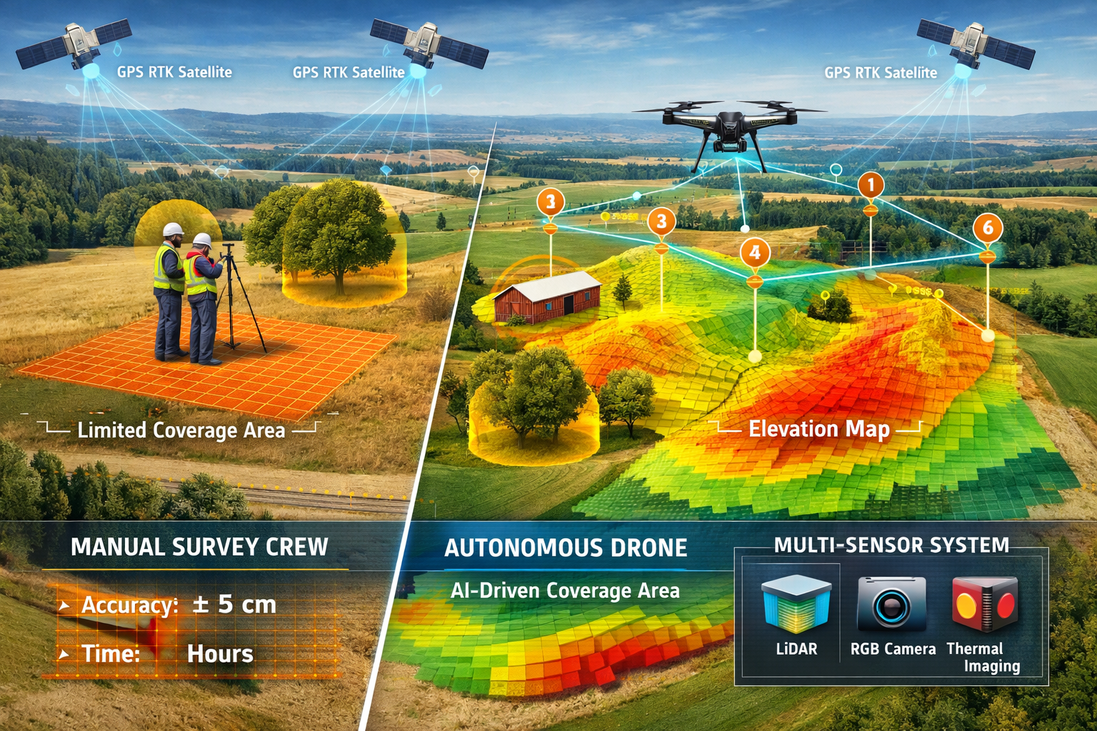
Real-Time Kinematic (RTK) and Post-Processed Kinematic (PPK) GNSS technology forms the backbone of modern autonomous surveying drones. These systems achieve centimeter-level positioning accuracy that meets professional survey-grade standards, fundamentally changing what's possible with aerial data collection.[2]
RTK systems receive correction data from a base station in real-time, allowing the drone to know its exact position within 1-2 centimeters during flight. PPK systems, alternatively, record raw GNSS data during the flight and apply corrections during post-processing, offering similar accuracy with greater operational flexibility in areas with limited connectivity.
The practical implications are profound:
- Reduced ground control points (GCPs) from dozens to just a handful, dramatically decreasing field preparation time
- Faster mobilization for remote locations where establishing traditional survey networks would be prohibitively expensive
- Consistent accuracy across the entire survey area, regardless of property size or terrain complexity
- Lower field costs through minimized equipment requirements and reduced crew time on site[2]
AI-Powered Flight Path Optimization
Modern autonomous surveying drones don't simply follow pre-programmed routes—they think. Onboard artificial intelligence processors analyze terrain data, weather conditions, and mission parameters to generate optimal flight paths that maximize efficiency while maintaining data quality standards.[1]
These intelligent systems perform several critical functions:
Terrain-Adaptive Altitude Adjustment 🛸
The drone automatically adjusts its altitude based on ground elevation changes, maintaining consistent ground sampling distance (GSD) across varied topography. This ensures uniform image resolution whether surveying valleys, hillsides, or flat agricultural land.
Real-Time Obstacle Detection and Avoidance
Advanced sensor arrays identify trees, buildings, power lines, and other obstacles during flight, automatically routing around hazards while maintaining survey coverage. This capability is particularly valuable for drone surveys of developed properties or forested areas.
Dynamic Mission Adjustment
If weather conditions change or battery levels require it, autonomous systems can pause missions, return to base, swap batteries (in drone-in-a-box configurations), and resume exactly where they left off—all without human intervention.[1]
Predictive Flight Planning
AI algorithms analyze historical data from similar properties to predict optimal flight parameters before takeoff, including ideal altitude, camera angles, overlap percentages, and flight speed for specific survey objectives.
Multi-Sensor Integration: Comprehensive Data Collection
The most advanced autonomous surveying platforms in 2026 integrate multiple sensor types to capture diverse data sets in a single flight mission. This multi-sensor approach transforms drones from simple camera platforms into comprehensive geospatial intelligence systems.[2]
| Sensor Type | Primary Applications | Key Advantages |
|---|---|---|
| LiDAR | Topographic surveys, forestry, utility corridors, mining volumetrics | Penetrates dense canopies, operates in low light, creates detailed 3D point clouds |
| RGB Cameras | Orthomosaic maps, visual documentation, change detection | High resolution imagery, natural color representation, familiar output format |
| Multispectral | Agricultural health monitoring, vegetation analysis, crop stress detection | Identifies plant health issues invisible to human eye, enables precision agriculture |
| Thermal Imaging | Infrastructure inspections, heat loss detection, water leak identification | Detects temperature variations, identifies structural issues, works day or night |
LiDAR-enabled UAVs have become the standard method for professional surveying applications, offering faster pulse repetition rates and better performance under dense canopies compared to earlier systems.[2] Modern LiDAR drones can capture millions of points per second, creating incredibly detailed 3D representations of terrain and structures.
The integration of these sensors enables autonomous systems to collect comprehensive data sets that would traditionally require multiple specialized survey crews and separate site visits. For agricultural properties, a single autonomous flight can simultaneously capture topographic data, crop health information, drainage patterns, and thermal variations—providing property owners with unprecedented insights for decision-making.
Cloud-Based Processing and Automated Deliverables
The autonomous revolution extends beyond data capture to processing and delivery. Modern systems automatically upload captured data to cloud-based processing platforms immediately after landing, significantly reducing turnaround time from weeks to hours or days.[1]
These platforms employ sophisticated algorithms to:
- Generate high-resolution orthomosaic maps with seamless image stitching
- Create accurate 3D terrain models from photogrammetry or LiDAR point clouds
- Produce Digital Surface Models (DSM) showing all features including vegetation and structures
- Generate Digital Elevation Models (DEM) representing bare earth terrain
- Calculate volumetric measurements for stockpiles, cut-and-fill operations, and land development
- Perform change detection analysis comparing surveys from different dates
The automation of these processing tasks eliminates manual bottlenecks and reduces the specialized expertise required to transform raw drone data into actionable survey deliverables. Property owners and developers can access interactive web-based viewers to explore their survey data, take measurements, and share findings with stakeholders—all without specialized GIS software.
Cost Savings and Efficiency Gains for Property Owners
The financial case for autonomous drones in land surveying: capturing large properties with single flights extends far beyond the obvious reduction in field time. When examining the total cost of ownership and operational efficiency, autonomous surveying systems deliver compelling return on investment across multiple dimensions.
Labor Cost Reduction: The Primary Driver
Traditional land surveying requires substantial human resources. A typical large property survey might involve:
- A survey crew of 2-4 professionals for field data collection
- Multiple days or weeks of site access depending on property size
- Specialized personnel for GPS base station setup and ground control point placement
- Office staff for data processing, CAD drafting, and report generation
- Project managers to coordinate logistics and quality control
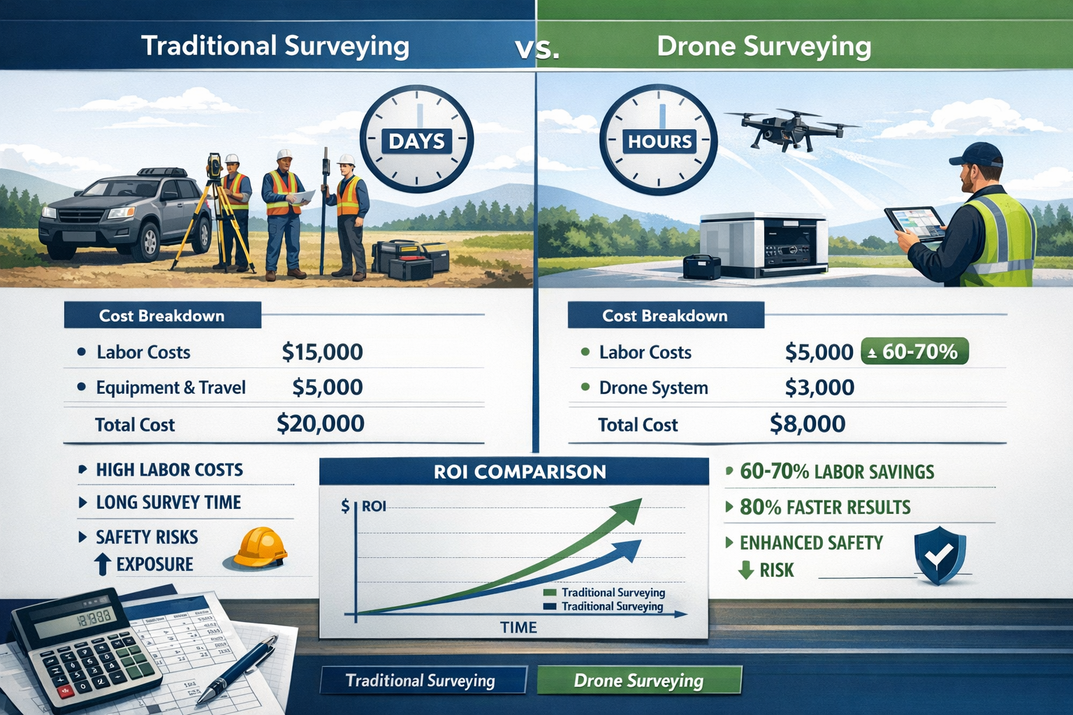
Autonomous drone systems fundamentally reshape this labor equation. A single trained operator can launch an autonomous mission covering hundreds of acres, with the drone handling all flight operations, data capture, and even landing without continuous manual control.[1] The labor cost reduction typically ranges from 60-70% compared to traditional methods, with the savings increasing proportionally for larger properties.
Consider a practical example: A 500-acre agricultural property requiring topographic surveying for drainage planning:
Traditional Survey Approach:
- 3-person crew × 5 days = 15 person-days
- Equipment rental and mobilization costs
- Estimated cost: £15,000-£25,000
Autonomous Drone Approach:
- 1 operator × 1-2 days (including setup and quality checks)
- Drone and processing subscription costs
- Estimated cost: £4,000-£8,000
The savings of £11,000-£17,000 on a single project demonstrate why property developers, agricultural operations, and infrastructure managers are rapidly adopting autonomous surveying technology.
Time Efficiency: Faster Data Collection and Delivery
Time represents another critical cost factor, particularly for development projects where delays cascade into financing costs, extended contractor schedules, and missed market opportunities. Autonomous drones in land surveying: capturing large properties with single flights dramatically compress project timelines.[2]
Field Data Collection Speed ⚡
Modern autonomous drones can survey 100-200 acres per hour depending on required resolution and terrain complexity. A property that would require weeks of traditional surveying can be completely captured in a single day or even hours. This speed advantage becomes particularly valuable for:
- Construction site monitoring requiring frequent progress updates
- Agricultural operations with narrow windows for decision-making
- Infrastructure corridor surveys where access restrictions limit field time
- Emergency response situations requiring rapid damage assessment
Reduced Site Disruption
Traditional surveying crews require access to the entire property, potentially disrupting ongoing operations, agricultural activities, or construction work. Autonomous drones capture data from above with minimal ground presence, allowing normal activities to continue uninterrupted. For commercial operations, this translates directly to avoided revenue losses.
Accelerated Processing and Delivery
Cloud-based automated processing eliminates the traditional bottleneck of manual data processing. Where conventional surveys might require 2-4 weeks for final deliverable preparation, autonomous drone surveys can provide preliminary results within 24-48 hours and final deliverables within a week.[1]
This acceleration enables:
- Faster design iterations for development projects
- Quicker decision-making for agricultural management
- Reduced holding costs for property acquisitions
- Improved project scheduling and coordination
Operational Error Reduction and Quality Consistency
Human error represents a hidden cost in traditional surveying—mistakes that require field remobilization, data reprocessing, or worst-case scenario, design errors discovered during construction. Autonomous systems minimize operational errors through consistent, repeatable processes that don't suffer from fatigue, distraction, or inconsistent technique.[1]
The quality benefits include:
Consistent Coverage and Overlap
Autonomous flight systems maintain precise image overlap percentages (typically 70-80% forward and side overlap) across the entire survey area. This consistency ensures reliable photogrammetric processing and eliminates gaps in coverage that might require costly re-flights.
Standardized Data Capture Parameters
Every image is captured with identical camera settings, altitude, and angle, producing uniform data quality. Traditional manual flights can exhibit variations in these parameters that complicate processing and reduce accuracy.
Automated Quality Checks
Modern autonomous systems perform real-time quality validation during flight, identifying potential issues like insufficient overlap, poor lighting conditions, or GPS signal degradation. If problems are detected, the system can automatically re-fly affected areas before leaving the site.
Traceable Accuracy Documentation
Autonomous systems generate comprehensive metadata for every survey, documenting exact camera positions, GPS accuracy indicators, and processing parameters. This documentation provides defensible accuracy statements critical for professional surveying applications and legal purposes.
For professionals conducting RICS commercial building surveys or other formal assessments, this quality consistency and documentation capability ensures survey data meets professional standards and regulatory requirements.
Safety Benefits: Eliminating Human Risk Exposure
While not traditionally considered a "cost," workplace safety incidents carry substantial financial and human costs. Enhanced safety through autonomous surveying eliminates human exposure to hazardous environments, delivering both ethical and economic benefits.[1]
High-risk surveying scenarios where autonomous drones provide critical safety advantages include:
🏗️ Active Construction Sites
Surveyors no longer need to navigate around heavy equipment, open excavations, or unstable structures. Autonomous drones capture comprehensive site data while personnel remain in safe zones.
⛏️ Mining Operations
Stockpile measurements and pit surveys can be conducted without personnel entering active mining areas, eliminating exposure to equipment strikes, slope failures, and other mining hazards.
🛣️ Highway and Infrastructure Corridors
Surveying active roadways, railways, or utility corridors traditionally requires traffic control, safety barriers, and personnel working in proximity to high-speed vehicles. Autonomous drones eliminate this exposure entirely.
🏔️ Difficult or Unstable Terrain
Steep slopes, wetlands, dense vegetation, and unstable ground present physical hazards to survey crews. Aerial data collection avoids these risks while often providing better data quality than ground-based methods in these challenging environments.
The safety benefits extend beyond direct incident prevention to include reduced insurance costs, improved worker morale, and elimination of safety-related project delays. For organizations conducting regular surveying operations, these factors contribute meaningfully to the total cost equation.
Applications Across Agricultural and Development Properties
The versatility of autonomous drones in land surveying: capturing large properties with single flights becomes evident when examining specific applications across different property types. The technology adapts seamlessly to diverse surveying needs, delivering specialized insights for agricultural operations, development projects, and infrastructure management.
Agricultural Land Management and Precision Farming
Modern agricultural operations increasingly rely on data-driven decision-making to optimize yields, manage resources efficiently, and maintain environmental stewardship. Autonomous drone surveying provides the comprehensive, timely data that precision agriculture demands.
Topographic Analysis for Drainage Planning 💧
Understanding water flow patterns is critical for crop health and soil conservation. Autonomous drones equipped with LiDAR create detailed Digital Elevation Models revealing subtle terrain variations that influence drainage. Farmers and agricultural consultants use this data to:
- Design effective drainage tile systems
- Identify areas prone to waterlogging or erosion
- Plan terracing and conservation structures
- Optimize irrigation system layouts
A single autonomous flight over a large farm can capture elevation data with 2-3 cm vertical accuracy, revealing drainage issues that would be difficult or impossible to identify through ground observation.[2]
Crop Health Monitoring with Multispectral Imaging
Autonomous drones equipped with multispectral sensors capture data beyond the visible spectrum, revealing crop stress, nutrient deficiencies, and disease before they're visible to the human eye. The NDVI (Normalized Difference Vegetation Index) and other vegetation indices calculated from this data enable:
- Variable rate fertilizer application reducing input costs
- Early disease detection allowing targeted treatment
- Yield prediction and harvest planning
- Irrigation management based on actual plant stress
The autonomous nature of these systems allows regular monitoring throughout the growing season, creating time-series data that reveals trends and enables proactive management interventions.
Acreage Verification and Boundary Documentation
For property transactions, insurance purposes, or agricultural program compliance, accurate acreage measurements are essential. Autonomous drone surveys provide legally defensible boundary and area calculations with precision exceeding traditional methods. The orthomosaic maps generated serve as permanent visual records of property conditions at specific dates.
Livestock Management and Infrastructure Assessment
Beyond crop production, autonomous surveys support livestock operations by documenting fence conditions, water source locations, pasture utilization patterns, and facility maintenance needs across large grazing properties. The aerial perspective reveals infrastructure issues that might be missed during ground inspections.
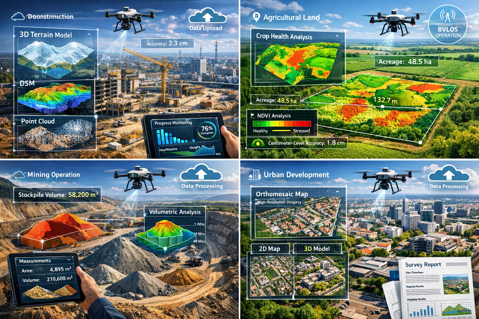
Construction and Development Site Monitoring
Development projects from residential subdivisions to large commercial complexes benefit enormously from the rapid, accurate data that autonomous surveying provides throughout the project lifecycle.
Pre-Development Topographic Surveys
Before design work begins, developers need accurate existing conditions surveys. Autonomous drones in land surveying: capturing large properties with single flights can capture comprehensive topographic data for large development parcels in a fraction of the time required for traditional surveys.[2]
The deliverables typically include:
- High-resolution orthomosaic imagery showing existing vegetation, structures, and features
- Digital Terrain Models for grading and drainage design
- Contour maps at user-specified intervals
- 3D point clouds for detailed design work
- Volumetric calculations for cut-and-fill analysis
This data integrates seamlessly with modern design software, allowing architects and engineers to begin work immediately. For professionals conducting building surveys, the comprehensive aerial documentation provides valuable context for property assessments.
Progress Monitoring and Documentation
Construction projects require regular monitoring to verify work completed, identify deviations from plans, and document progress for payment applications. Autonomous drones can survey large construction sites weekly or even daily, creating a visual and dimensional record of project evolution.
The benefits include:
- Accurate earthwork volume calculations for payment verification
- Early detection of grading errors before they become costly problems
- Visual documentation protecting against disputes
- Improved coordination between trades through current as-built information
- Enhanced project management through data-driven decision making
As-Built Surveys and Final Documentation
Upon project completion, autonomous surveys provide comprehensive as-built documentation showing final site conditions, building locations, grading, and infrastructure. This documentation serves multiple purposes including regulatory compliance, facility management, and future renovation planning.
Infrastructure Corridor Surveys
Linear infrastructure projects including highways, railways, pipelines, and utility corridors present unique surveying challenges due to their length, varied terrain, and often restricted access. Autonomous drones excel in these applications.
Utility Corridor Mapping and Vegetation Management
Power transmission companies, pipeline operators, and telecommunications providers manage infrastructure corridors spanning thousands of miles. Autonomous drone surveys with LiDAR provide detailed 3D mapping of:
- Vegetation encroachment threatening power lines
- Terrain changes affecting pipeline integrity
- Access road conditions
- Tower and pole conditions
- Right-of-way encroachments
The LiDAR capability to penetrate dense canopies reveals ground conditions and infrastructure details obscured by vegetation, critical for maintenance planning and regulatory compliance.[2]
Highway and Railway Surveys
Transportation infrastructure requires regular surveying for maintenance planning, capacity expansion, and safety improvements. Autonomous drones capture comprehensive corridor data including:
- Pavement conditions and deterioration
- Drainage system functionality
- Embankment stability
- Bridge and structure conditions
- Traffic pattern analysis (when equipped with appropriate sensors)
The ability to survey active transportation corridors without traffic disruption represents a major safety and cost advantage over traditional methods.
BVLOS Operations for Extended Coverage
Beyond Visual Line of Sight (BVLOS) operations are increasingly approved for commercial use in 2026, with Remote ID fully integrated into airspace management.[2] This regulatory evolution enables autonomous drones to survey extremely long corridors in single missions, dramatically improving efficiency for linear infrastructure projects.
Drone-in-a-box systems stationed along corridors can automatically deploy on scheduled missions or in response to specific triggers (like severe weather events), providing continuous monitoring without human intervention.
Mining and Quarry Operations
Extractive industries have been early adopters of autonomous surveying technology due to the combination of hazardous working environments, need for frequent volumetric measurements, and large site areas.
Stockpile Volume Calculations
Accurate inventory of material stockpiles is critical for financial reporting, production planning, and sales. Autonomous drones conduct regular stockpile surveys, calculating volumes with accuracy rivaling traditional terrestrial methods while eliminating the need for personnel to climb potentially unstable stockpiles.[2]
The frequency of autonomous surveys can increase from monthly or quarterly (typical with traditional methods) to weekly or even daily, providing real-time inventory data that improves operational decision-making.
Pit Progression Monitoring
Mining operations require regular surveys to track excavation progress, ensure compliance with mining plans, calculate remaining reserves, and plan future operations. Autonomous systems provide:
- Detailed 3D models showing current pit conditions
- Change detection comparing current conditions to previous surveys or design plans
- Volume calculations for material removed
- Slope stability analysis data
- Environmental compliance documentation
Reclamation and Environmental Monitoring
Post-mining reclamation requires documentation of restoration activities and ongoing monitoring of environmental conditions. Autonomous surveys provide cost-effective regular monitoring, documenting vegetation establishment, erosion control effectiveness, and compliance with reclamation plans.
Urban Planning and Municipal Applications
Local governments and urban planners increasingly leverage autonomous drone surveying for comprehensive community documentation and planning purposes.
Comprehensive City Mapping
Municipalities can create detailed 3D models of entire communities, providing valuable data for:
- Zoning and land use planning
- Infrastructure planning and management
- Emergency response planning
- Tax assessment and property records
- Public engagement and visualization
Flood Risk Assessment and Stormwater Management
Detailed elevation data from autonomous LiDAR surveys enables sophisticated hydrological modeling, identifying flood-prone areas and optimizing stormwater infrastructure. This data supports climate adaptation planning and infrastructure investment prioritization.
Historic Preservation Documentation
Autonomous drones create detailed 3D documentation of historic structures and districts, preserving a digital record and supporting restoration planning. The non-invasive nature of aerial surveying is particularly appropriate for sensitive historic properties.
For professionals conducting RICS Building Surveys Level 3 on historic or complex properties, drone-captured data provides valuable supplementary documentation of roof conditions and other difficult-to-access areas.
Regulatory Landscape and Future Developments
The rapid advancement of autonomous drones in land surveying: capturing large properties with single flights occurs within an evolving regulatory framework designed to balance innovation with safety and privacy concerns. Understanding current regulations and anticipated developments is essential for property owners and surveying professionals planning to leverage this technology.
Current Regulatory Framework in 2026
Beyond Visual Line of Sight (BVLOS) Operations
One of the most significant regulatory developments enabling large property surveys has been the progressive approval of BVLOS operations for commercial use. In 2026, many jurisdictions have established clear pathways for BVLOS authorization, recognizing that autonomous systems with sophisticated detect-and-avoid capabilities can operate safely beyond the operator's visual range.[2]
BVLOS approval typically requires:
- Demonstrated reliability of autonomous flight systems
- Robust detect-and-avoid capabilities
- Comprehensive risk assessment and mitigation planning
- Integration with air traffic management systems
- Remote ID compliance for airspace awareness
These approvals enable single-flight coverage of properties spanning hundreds or even thousands of acres, fundamentally changing the economics of large-area surveying.
Remote ID Integration
Remote ID systems, now fully integrated into airspace management, broadcast drone identification, location, and operational information to authorities and other airspace users.[2] This technology enables:
- Improved airspace safety through awareness of drone operations
- Enforcement of regulations and restricted areas
- Public accountability and privacy protection
- Integration with manned aviation traffic management
For surveying operations, Remote ID compliance is typically seamless, with modern autonomous drones incorporating the required technology as standard equipment.
Privacy and Data Protection Considerations
Aerial surveying raises legitimate privacy concerns, particularly when conducted over or adjacent to residential properties. Responsible surveying practices in 2026 include:
- Notification of adjacent property owners when conducting surveys
- Data handling protocols complying with privacy regulations
- Appropriate resolution selection balancing survey needs with privacy
- Secure data storage and transmission
- Clear policies on data retention and sharing
Property owners commissioning surveys should ensure their surveying providers follow established privacy protocols and comply with applicable data protection regulations.
Emerging Technologies and Future Capabilities
The autonomous surveying landscape continues to evolve rapidly, with several emerging technologies poised to further enhance capabilities and expand applications.
Advanced AI and Machine Learning Integration 🤖
Current autonomous systems use AI primarily for flight path optimization and obstacle avoidance. Next-generation systems will incorporate AI throughout the surveying workflow:
- Automated feature extraction identifying buildings, roads, vegetation types, and infrastructure directly from captured data
- Anomaly detection automatically flagging potential issues like structural damage, crop disease, or unauthorized changes
- Predictive maintenance analyzing infrastructure conditions to forecast future maintenance needs
- Intelligent data collection adapting sensor parameters in real-time based on scene content and survey objectives
These AI enhancements will reduce the specialized expertise required to extract actionable insights from survey data, making autonomous surveying accessible to a broader range of users.
Swarm Technology for Massive Area Coverage
Coordinated swarms of autonomous drones working collaboratively could survey extremely large properties or entire regions in remarkably short timeframes. Research and early commercial applications are exploring:
- Multiple drones sharing a single survey mission with coordinated flight paths
- Automatic task allocation based on individual drone capabilities and battery status
- Collaborative obstacle avoidance and airspace deconfliction
- Distributed processing reducing data transfer requirements
While still emerging, swarm technology could eventually enable single-day surveys of properties spanning thousands of acres.
Enhanced Sensor Capabilities
Sensor technology continues advancing, with improvements in:
- Higher resolution cameras providing greater detail from higher altitudes
- Improved LiDAR systems with faster pulse rates and better penetration
- Hyperspectral imaging capturing hundreds of spectral bands for detailed material identification
- Gas detection sensors identifying methane leaks, air quality issues, or hazardous materials
- Acoustic sensors detecting equipment malfunctions or wildlife
These sensor advancements will expand the range of property characteristics that can be documented through autonomous aerial surveys.
Drone-in-a-Box Permanent Installations
Automated drone-in-a-box systems that autonomously deploy, conduct missions, and return to weatherproof charging stations are becoming increasingly common for properties requiring regular monitoring.[2] Applications include:
- Construction sites with daily progress monitoring requirements
- Agricultural operations conducting weekly crop health assessments
- Infrastructure corridors with continuous monitoring needs
- Security and surveillance applications
These systems operate with minimal human intervention, automatically conducting scheduled missions and alerting operators only when issues are detected or intervention is required.
Integration with Digital Twin Technology
The convergence of autonomous surveying with digital twin platforms represents a transformative development for property management and development. Digital twins—virtual replicas of physical properties continuously updated with real-world data—rely on regular, accurate surveying to maintain currency.
Autonomous drones provide the ideal data collection mechanism for digital twins:
- Regular automated updates keeping digital models synchronized with physical reality
- Multi-sensor data integration providing comprehensive property information
- Change detection automatically identifying deviations from design or previous conditions
- Predictive analytics using historical survey data to forecast future conditions
For large development projects, infrastructure management, and agricultural operations, the combination of autonomous surveying and digital twin technology enables unprecedented visibility and control.
Selecting the Right Autonomous Surveying Solution
Property owners and organizations considering autonomous drones in land surveying: capturing large properties with single flights face numerous options ranging from purchasing equipment to engaging specialized surveying services. Understanding the key decision factors ensures optimal outcomes.
In-House Capabilities vs. Professional Services
When to Consider In-House Systems:
Organizations with frequent surveying needs across multiple properties may benefit from developing in-house autonomous surveying capabilities. This approach makes sense when:
- Survey requirements occur monthly or more frequently
- Properties are geographically concentrated allowing efficient equipment utilization
- Staff have or can develop technical expertise in drone operations and data processing
- Capital investment can be justified by avoided service costs over 2-3 years
- Immediate data access provides competitive or operational advantages
When Professional Services Are Optimal:
For many property owners, engaging professional surveying services delivers better outcomes at lower total cost. Professional services are typically preferable when:
- Surveying needs are occasional or project-specific
- Regulatory compliance and professional liability protection are critical
- Specialized expertise is required for complex surveying applications
- Capital investment in equipment cannot be justified by usage frequency
- Focus should remain on core business activities rather than developing surveying expertise
Professional firms offering drone surveys bring established equipment, trained personnel, insurance coverage, and quality assurance processes that eliminate the learning curve and risk associated with developing in-house capabilities.
Key Specifications and Capabilities to Consider
Whether purchasing equipment or evaluating service providers, understanding critical specifications ensures the solution meets project requirements.
Flight Time and Coverage Capacity
Battery life directly determines the area that can be surveyed in a single flight. Modern surveying drones typically offer 25-45 minutes of flight time, translating to coverage of 100-300 acres depending on required resolution and terrain. For large properties, consider:
- Battery capacity and flight endurance
- Availability of quick-swap battery systems
- Drone-in-a-box capabilities for automated battery management
- Ability to pause and resume missions across multiple flights
Sensor Payload and Quality
The sensors determine what data can be captured and at what accuracy. Evaluate:
- Camera resolution (20+ megapixels for professional surveying)
- LiDAR specifications (points per second, accuracy, range)
- Availability of specialized sensors (multispectral, thermal)
- Sensor integration and synchronization quality
- Gimbal stabilization performance
Positioning Accuracy
GPS/GNSS capabilities directly impact survey accuracy. Look for:
- RTK or PPK capability for centimeter-level positioning
- Multi-constellation GNSS support (GPS, GLONASS, Galileo, BeiDou)
- Compatibility with local RTK networks or base station requirements
- Documented accuracy specifications
Autonomous Capabilities
The degree of autonomy varies significantly between systems. Assess:
- Automated mission planning and execution
- Terrain-following capabilities
- Obstacle detection and avoidance sophistication
- Ability to adapt to changing conditions
- BVLOS certification and capabilities
Data Processing and Deliverables
The processing workflow determines turnaround time and deliverable quality. Consider:
- Processing software capabilities and ease of use
- Cloud processing availability and speed
- Standard deliverable formats (orthomosaics, point clouds, DEMs, etc.)
- Integration with design and GIS software
- Quality control and accuracy validation processes
Cost Considerations and ROI Analysis
Understanding the total cost of ownership or service engagement enables informed decision-making.
Equipment Purchase Costs:
- Professional surveying drone: £15,000-£50,000+
- RTK base station or network subscription: £3,000-£8,000
- Processing software licenses: £2,000-£10,000 annually
- Training and certification: £2,000-£5,000
- Insurance and maintenance: £2,000-£5,000 annually
Service Engagement Costs:
- Small property survey (under 50 acres): £1,500-£4,000
- Medium property survey (50-200 acres): £3,000-£8,000
- Large property survey (200+ acres): £6,000-£15,000+
- Specialized applications (LiDAR, multispectral): Premium pricing
When comparing options, consider total project costs including field time, processing, deliverable preparation, and professional liability. For occasional users, professional services typically deliver superior ROI. For organizations with frequent needs, equipment purchase may be justified, though ongoing training, maintenance, and technology refresh costs should be factored into the analysis.
Understanding surveyor pricing helps establish realistic budget expectations for professional services.
Quality Assurance and Accuracy Validation
Regardless of whether surveying is conducted in-house or through professional services, quality assurance processes ensure deliverables meet project requirements.
Ground Control Points (GCPs)
Even with RTK/PPK systems, strategic placement of ground control points provides independent accuracy validation. Best practices include:
- Minimum 3-5 GCPs for RTK surveys, more for PPK or non-RTK systems
- GCPs distributed throughout the survey area, particularly at corners and elevation extremes
- Professional survey-grade positioning of GCPs
- Clear marking visible in aerial imagery
- Documentation of GCP coordinates and accuracy
Independent Check Points
Separate from GCPs used for processing, independent check points provide unbiased accuracy assessment. These points, surveyed with traditional methods but not used in drone data processing, allow quantitative accuracy verification.
Processing Quality Indicators
Modern photogrammetry and LiDAR processing software provides numerous quality metrics:
- Image tie point residuals
- Camera calibration parameters and uncertainty
- Point cloud density and coverage
- Georeferencing accuracy estimates
- Processing report documentation
Reviewing these indicators ensures data quality meets project specifications.
Professional Standards Compliance
For surveys requiring professional certification, ensure compliance with relevant standards:
- RICS (Royal Institution of Chartered Surveyors) guidelines for UK projects
- Local surveying board requirements and licensure
- Industry-specific standards (construction, mining, agriculture)
- Legal requirements for boundary surveys or property transactions
Professional surveyors conducting RICS building surveys or other formal assessments ensure compliance with applicable professional standards and provide appropriate certifications and liability coverage.
Conclusion: Embracing the Autonomous Surveying Revolution
The transformation of land surveying through autonomous drones in land surveying: capturing large properties with single flights represents far more than incremental technological improvement—it's a fundamental reimagining of how geospatial data is captured, processed, and utilized for property management and development. In 2026, the convergence of GPS RTK systems, artificial intelligence, multi-sensor integration, and cloud-based processing has created surveying capabilities that would have seemed impossible just a decade ago.
The benefits are compelling and measurable: 60-70% cost reductions through minimized labor requirements, 80% time savings through rapid data collection and automated processing, centimeter-level accuracy rivaling traditional methods, and enhanced safety eliminating human exposure to hazardous environments.[1][3] These advantages apply across diverse applications from agricultural land management and construction site monitoring to infrastructure surveys and urban planning.
For property owners, developers, agricultural operators, and infrastructure managers, the strategic question is no longer whether to adopt autonomous surveying technology, but rather how to implement it most effectively for specific needs and circumstances. The technology has matured beyond experimental status to become the professional standard for large-area surveying applications.
Actionable Next Steps
For Property Owners and Developers:
-
Assess your surveying needs – Document the frequency, area coverage, and accuracy requirements for your properties to determine whether in-house capabilities or professional services provide optimal value
-
Engage qualified professionals – Consult with experienced surveying firms offering autonomous drone capabilities to understand how the technology applies to your specific properties and objectives
-
Request demonstration surveys – Many professional surveyors offer pilot projects or demonstrations allowing you to evaluate deliverable quality and applicability before committing to larger engagements
-
Integrate survey data into decision-making – Develop workflows that leverage regular, accurate survey data for operational decisions, planning, and management
-
Stay informed about regulatory developments – Monitor evolving regulations regarding BVLOS operations, privacy requirements, and professional standards affecting autonomous surveying
For Organizations Considering In-House Capabilities:
-
Conduct thorough ROI analysis – Calculate total cost of ownership including equipment, training, software, maintenance, and personnel time against avoided service costs
-
Invest in proper training – Ensure personnel receive comprehensive training in both flight operations and data processing to maximize equipment value
-
Establish quality assurance protocols – Develop documented procedures for mission planning, data collection, processing, and accuracy validation
-
Maintain regulatory compliance – Stay current with licensing requirements, operational restrictions, and professional standards
-
Plan for technology evolution – Recognize that drone technology evolves rapidly; budget for periodic equipment upgrades to maintain competitive capabilities
For Agricultural Operations:
-
Start with specific applications – Begin with focused applications like drainage planning or crop health monitoring before expanding to comprehensive farm management
-
Integrate with precision agriculture systems – Ensure survey data integrates with existing farm management software and variable rate application equipment
-
Establish regular monitoring schedules – Maximize value through consistent, scheduled surveys creating time-series data revealing trends and patterns
-
Collaborate with agronomic advisors – Work with agricultural consultants who can interpret multispectral and other specialized data for actionable recommendations
The autonomous surveying revolution is not a future possibility—it's the present reality transforming how professionals capture and utilize geospatial data. Organizations that embrace this technology position themselves for enhanced efficiency, reduced costs, improved safety, and data-driven decision-making that delivers competitive advantages in increasingly demanding markets.
Whether through professional services or in-house capabilities, autonomous drones in land surveying: capturing large properties with single flights offers unprecedented opportunities for property owners and managers to gain comprehensive, accurate, timely insights into their most valuable assets. The question is not whether to adopt this technology, but how quickly you can leverage it to transform your operations.
For expert guidance on implementing autonomous drone surveying for your properties, contact professional surveyors with established expertise in this rapidly evolving field.
References
[1] Self Flying Uavs For Survey Mapping Are Redefining Aerial Intelligence – https://www.dronitech.com/self-flying-uavs-for-survey-mapping-are-redefining-aerial-intelligence/
[2] How Drones Are Transforming Surveying Mapping And Inspection In 2026 – https://www.uavsphere.com/post/how-drones-are-transforming-surveying-mapping-and-inspection-in-2026
[3] Ai Drones For Surveying Enhancing Land Mapping Precision And Efficiency – https://www.arcsurveyors.com/ai-drones-for-surveying-enhancing-land-mapping-precision-and-efficiency/