The property surveying industry stands at a transformative crossroads in 2026. What once required weeks of manual data collection, processing, and analysis can now be accomplished in days—or even hours. AI-Driven Precision in Property Surveying: Revolutionizing Workflows in 2026 represents more than just technological advancement; it marks a fundamental shift in how surveyors work, how clients receive information, and how the entire property ecosystem operates. From autonomous drones that intelligently map vast development sites to real-time 3D digital twins that allow stakeholders to visualize properties in unprecedented detail, artificial intelligence is reshaping every aspect of the surveying profession.
This revolution arrives at a critical moment. The surveying industry faces significant workforce shortages while demand for faster, more accurate results continues to accelerate.[4] Clients expect detailed insights delivered quickly, environmental regulations demand comprehensive assessments, and construction projects require seamless collaboration across multiple disciplines. AI-powered tools are emerging as the solution to these challenges, enabling surveyors to work smarter, deliver more value, and meet the evolving expectations of 2026.
Key Takeaways
✅ Autonomous drones with predictive optimization now plan their own flight paths, automatically adjusting altitude and sensor selection to achieve optimal readings across large-scale properties.[1]
✅ Real-time 3D digital twins have replaced static reports as standard deliverables, providing interactive, continuously updating models that allow stakeholders to visualize property conditions dynamically.[1]
✅ Cloud-based collaboration platforms enable instant file sharing, browser-based 3D visualization, and real-time communication between surveyors, engineers, and architects, eliminating delays from traditional document workflows.[1]
✅ AI serves as an efficiency tool, not a replacement for professional judgment—recent industry testing confirms that qualified surveyor validation remains essential for accurate risk assessment and client advice.[3]
✅ Reduced site visits and predictive risk analysis are delivering measurable time and cost savings while improving accuracy across residential, commercial, and development projects.
Understanding AI-Driven Precision in Property Surveying: Revolutionizing Workflows in 2026

What Makes 2026 Different from Previous Years
The surveying technology landscape has evolved rapidly over the past decade, but 2026 represents a distinct inflection point. Previous years saw the introduction of individual technologies—drones, laser scanning, photogrammetry—as separate tools in the surveyor's toolkit. In 2026, these technologies have converged into integrated AI-powered ecosystems that work together seamlessly.
According to industry experts at Trimble, six key trends are defining the 2026 surveying landscape, with reality capture integration, AI-enhanced workflows, and cloud-based collaboration forming the core pillars.[4] The launch of Trimble AI Studio in early 2026 enables users to build and refine their own AI agents across the Trimble ecosystem, marking a shift from using pre-built AI tools to customizing artificial intelligence for specific surveying applications.[8]
This integration means that data collected by autonomous drones is automatically processed by AI algorithms, converted into 3D models, analyzed for potential issues, and delivered to clients through cloud platforms—all without manual intervention at each step. The result is a complete workflow transformation rather than incremental improvements to existing processes.
The Core Technologies Powering the Revolution
Several technological advancements have converged to enable AI-driven precision in property surveying:
🤖 Machine Learning and Pattern Recognition
AI algorithms can now identify structural defects, boundary irregularities, and environmental concerns by analyzing vast datasets of property images and measurements. These systems learn from thousands of previous surveys, improving their accuracy with each new project.
📡 Multi-Sensor Integration
Modern surveying drones carry multiple sensors simultaneously—LiDAR for precise measurements, thermal imaging for detecting moisture and insulation issues, and high-resolution cameras for visual documentation. AI coordinates these sensors, determining which data sources to prioritize based on property characteristics and survey objectives.[1]
☁️ Cloud Computing Infrastructure
Processing the massive datasets generated by modern surveying equipment requires substantial computational power. Cloud platforms provide the processing capacity needed while enabling real-time collaboration and instant access to survey data from any location.
🔄 Real-Time Data Processing
Unlike traditional workflows where data processing occurred after fieldwork completion, AI-powered systems process information in real-time. Surveyors can identify issues during site visits and collect additional data immediately rather than scheduling return trips.
How AI-Driven Precision in Property Surveying Transforms Daily Operations
Autonomous Drone Capabilities with Predictive Optimization
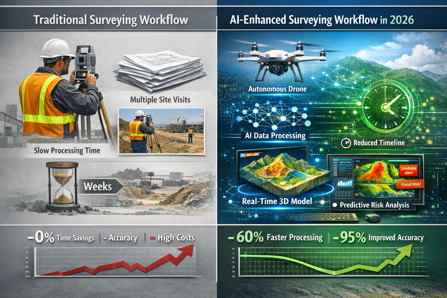
The evolution of drone technology in surveying represents one of the most visible transformations in the field. In 2026, drones have moved beyond simple remote-controlled aircraft to become autonomous intelligent systems capable of making real-time decisions about data collection.
Flight paths can now be planned using predictive modeling, with drones automatically adjusting altitude, angle, and sensor selection to achieve optimal readings.[1] When surveying a large commercial property, the drone's AI analyzes terrain variations, building heights, vegetation density, and lighting conditions to determine the most efficient data collection strategy.
For example, when approaching a section of property with dense tree coverage, the drone automatically increases its LiDAR scanning intensity while adjusting its flight altitude to penetrate the canopy. When surveying building facades, it recognizes architectural features and adjusts camera angles to capture detailed imagery of potential defect areas.
This autonomous capability delivers several practical benefits:
- Reduced survey time: Multi-sensor drones can complete in one flight what previously required multiple site visits with different equipment
- Improved safety: Dangerous areas like steep roofs or unstable structures can be surveyed without putting personnel at risk
- Consistent data quality: AI-controlled flight paths eliminate variations caused by different operators
- Cost efficiency: Fewer site visits and faster data collection reduce overall project costs
When choosing the right property survey, clients can now benefit from drone-enhanced inspections that provide more comprehensive data than traditional ground-based methods alone.
Real-Time 3D Digital Twins as Standard Deliverables
Perhaps the most significant shift in surveying deliverables is the transition from static reports to interactive 3D digital twins. High-fidelity, interactive 3D models now update continuously as new data is collected, allowing developers, engineers, and planners to visualize how land behaves under various conditions.[1]
A digital twin is more than just a 3D visualization—it's a dynamic representation of a property that incorporates:
| Digital Twin Component | Traditional Report Equivalent | Added Value |
|---|---|---|
| Interactive 3D model | Static photographs and diagrams | Explore property from any angle, measure distances, zoom to details |
| Real-time data layers | Separate specialist reports | Toggle between structural, thermal, moisture, and environmental data |
| Temporal tracking | Single point-in-time assessment | Compare conditions over time, track changes, predict future issues |
| Collaborative annotations | Email chains and meeting notes | Stakeholders add comments directly to specific locations in the model |
| Integration with BIM | Separate architectural drawings | Seamless connection between survey data and design/construction plans |
For clients commissioning a RICS home survey, this means receiving a comprehensive digital model they can explore interactively rather than reading through pages of text descriptions. They can virtually "walk through" the property, click on areas of concern to see detailed analysis, and share the model with contractors to obtain accurate repair quotes.
Cloud-Based Platforms Replacing Static Documents
The surveying profession has fundamentally changed how it delivers information to clients. Surveying deliverables have shifted from static documents to interactive, cloud-enabled formats featuring instant file sharing, 3D visualization in browser, real-time revision syncing, and integrated communication with engineers and architects.[1]
Key advantages of cloud-based survey platforms include:
📱 Accessibility: Clients, lenders, solicitors, and contractors can access survey data from any device with an internet connection, eliminating delays waiting for document transfers.
🔄 Version Control: When additional information is added or corrections are made, all stakeholders automatically see the updated version, preventing confusion from outdated reports.
💬 Integrated Communication: Rather than separate email threads discussing survey findings, conversations happen directly within the platform, linked to specific locations or issues in the survey data.
📊 Analytics and Insights: Cloud platforms can analyze survey data across multiple properties, identifying trends and patterns that inform better decision-making for property portfolios.
🔐 Security and Compliance: Enterprise-grade security protects sensitive property information while maintaining audit trails for regulatory compliance.
For those wondering how long does a homebuyers survey take, cloud-based workflows have significantly reduced turnaround times by eliminating bottlenecks in data processing and report generation.
AI Applications Across Different Survey Types in 2026
Residential Property Surveys
AI-driven precision has transformed how residential properties are surveyed, making comprehensive assessments more accessible and affordable. The technology particularly benefits homebuyers who need detailed information quickly to meet transaction deadlines.
Automated Defect Detection
Machine learning algorithms trained on thousands of residential surveys can identify common defects with remarkable accuracy. When analyzing photographs and thermal imagery, AI systems flag potential issues such as:
- Damp and moisture penetration
- Roof deterioration and missing tiles
- Structural movement and cracking patterns
- Insulation deficiencies
- Drainage problems
These automated assessments don't replace professional surveyor judgment but provide a comprehensive initial screening that ensures nothing is overlooked. Surveyors can then focus their expertise on evaluating the significance of identified issues and recommending appropriate actions.
Predictive Risk Analysis
Beyond identifying current defects, AI systems can predict future maintenance requirements based on property age, construction type, local climate data, and observed condition patterns. This predictive capability helps homebuyers understand not just the property's current state but likely expenses over the next 5-10 years.
For clients comparing the difference between level 2 and level 3 survey, AI-enhanced surveys can provide more detailed analysis at each level, delivering greater value regardless of which survey type they choose.
Commercial Building Surveys
Commercial properties present unique surveying challenges due to their size, complexity, and the higher stakes involved in commercial transactions. AI-driven precision addresses these challenges through:
Large-Scale Data Processing
Commercial buildings often span multiple floors and extensive grounds. Autonomous drones can survey entire commercial complexes in hours, generating terabytes of data. AI processes this information to create comprehensive building models that would take weeks to produce manually.
Multi-System Analysis
Commercial properties have complex mechanical, electrical, and plumbing systems. AI can analyze thermal imagery to identify HVAC inefficiencies, detect electrical hotspots indicating potential failures, and map plumbing systems to identify leak risks.
Compliance and Regulatory Assessment
AI systems can cross-reference building conditions against regulatory requirements, identifying compliance gaps and potential violations. This capability is particularly valuable for RICS commercial building surveys where regulatory compliance is a critical concern.
Portfolio Management
For property investors managing multiple commercial assets, AI enables comparative analysis across portfolios, identifying which properties require immediate attention and optimizing maintenance budgets.
Development and Agricultural Land Surveys
Large-scale land surveying has perhaps benefited most dramatically from AI-driven automation. Multi-sensor drones provide unprecedented detail for large agricultural, commercial, and development-scale properties.[1]
Topographical Mapping
AI-enhanced photogrammetry and LiDAR create highly accurate topographical maps showing elevation changes, drainage patterns, and terrain characteristics essential for development planning.
Environmental Assessment
As environmental regulations become more stringent, surveyors are using AI-enhanced assessment tools to evaluate and mitigate environmental impacts, supporting responsible land development and resource management.[1] AI can identify protected habitats, assess soil contamination risks, and evaluate flood susceptibility.
Boundary Determination
AI assists in analyzing historical boundary records, comparing them with current survey data, and identifying discrepancies that require resolution. This capability is particularly valuable for boundary surveys where precision is essential.
Specialist Defect Surveys
When specific concerns require detailed investigation, AI enhances specialist surveys by providing targeted analysis:
Subsidence and Structural Movement
AI can analyze crack patterns, compare measurements over time, and predict whether movement is ongoing or historic. For subsidence surveys, this predictive capability helps determine whether monitoring or immediate intervention is required.
Damp and Moisture Investigation
Thermal imaging combined with AI analysis can map moisture patterns throughout a building, identifying sources and extent of damp issues. This technology has transformed damp survey accuracy and efficiency.
Structural Integrity Assessment
For structural surveys, AI can analyze load-bearing elements, identify stress concentrations, and evaluate structural adequacy for proposed alterations or change of use.
The Critical Balance: AI Capabilities and Professional Limitations
What AI Can Do Exceptionally Well
The enthusiasm surrounding AI in property surveying is justified by genuine capabilities that deliver measurable improvements:
✅ Data Processing Speed
AI can analyze thousands of images, measurements, and data points in minutes, identifying patterns and anomalies that would take humans days or weeks to process manually.
✅ Consistency and Completeness
AI systems apply the same analytical criteria to every survey, eliminating the risk of overlooking issues due to fatigue or distraction.
✅ Pattern Recognition Across Large Datasets
By analyzing data from thousands of previous surveys, AI can identify subtle indicators of problems that might not be obvious in isolation.
✅ Administrative Task Automation
AI excels at routine tasks such as initial document review, data compilation, measurement calculations, and report formatting, freeing surveyors to focus on interpretation and client consultation.[3]
✅ Predictive Modeling
AI can forecast future maintenance requirements, deterioration patterns, and potential failures based on current conditions and historical data.
What AI Cannot Replace: The Essential Human Element
Despite impressive capabilities, recent testing has revealed critical limitations that define AI's proper role in professional surveying. In January 2026, building consultancy firm Eddisons published testing results in RICS Modus magazine revealing significant gaps in AI performance.[3]
"AI-generated lease summaries identified key clauses but overlooked important provisions, demonstrating that AI cannot replace professional judgment and requires qualified surveyor validation."[3]
❌ Contextual Understanding
AI lacks the ability to understand the broader context of property conditions. A crack that AI identifies as "moderate severity" might be insignificant in one building type but critical in another, depending on construction methods, age, and usage.
❌ Professional Judgment and Risk Assessment
Determining whether a defect requires immediate action, monitoring, or is acceptable requires professional experience that considers multiple factors beyond what AI can quantify.
❌ Client-Specific Advice
Every client has unique circumstances, risk tolerance, and objectives. Tailoring advice to individual client needs requires human understanding and communication skills that AI cannot replicate.[3]
❌ Ethical and Liability Considerations
Professional surveyors carry insurance and regulatory obligations. They make judgments that balance technical assessment with ethical responsibilities to clients and the public—decisions that cannot be delegated to algorithms.
The Four Risk Areas Identified by RICS
The January 2026 RICS analysis identified four key areas where AI affects building surveying, each requiring careful management:[3]
-
Reporting Quality: AI-generated content may lack the nuance and property-specific context that characterizes high-quality professional reports.
-
Over-Reliance on Automation: There's a risk that surveyors might accept AI outputs without sufficient critical review, potentially missing errors or inappropriate conclusions.
-
Human Interpretation Requirements: Complex situations require professional interpretation that considers factors AI cannot evaluate.
-
Inaccuracy Concerns: AI systems can produce confident-sounding but incorrect assessments, particularly when encountering situations outside their training data.
Understanding surveyor pricing in 2026 means recognizing that professional fees reflect not just data collection but the critical human expertise that interprets findings and provides tailored advice.
Real-World Applications: Case Studies and Practical Examples

Case Study 1: Reducing Site Visits for Large Commercial Property
A commercial property investor needed to survey a 50,000 square foot warehouse complex with multiple buildings across a 10-acre site. Traditional surveying would have required multiple site visits over several weeks.
AI-Driven Approach:
- Single autonomous drone survey captured comprehensive data in 4 hours
- AI processed LiDAR, thermal, and photographic data overnight
- 3D digital twin delivered within 48 hours
- Surveyor reviewed AI-flagged concerns and provided professional assessment
- Client accessed interactive model to explore findings
Results:
- 75% reduction in survey time
- 60% cost savings compared to traditional methods
- More comprehensive data than ground-based survey alone
- Client could share model with contractors for accurate repair quotes
Case Study 2: Predictive Risk Analysis for Residential Purchase
First-time homebuyers were purchasing a 1930s semi-detached property and needed to understand potential maintenance costs over the next decade.
AI-Enhanced Survey Process:
- Standard homebuyer survey enhanced with AI predictive analysis
- AI analyzed property age, construction type, current condition, and local climate data
- System predicted likely maintenance requirements over 10-year period
- Professional surveyor validated predictions and provided prioritized recommendations
- Interactive digital twin allowed buyers to explore property virtually
Results:
- Buyers received 10-year maintenance forecast with estimated costs
- Identified critical roof replacement needed within 3-5 years
- Buyers negotiated purchase price reduction based on documented findings
- Comprehensive data gave buyers confidence in purchase decision
Case Study 3: Development Site Environmental Assessment
A property developer needed environmental assessment of a 50-acre development site with suspected contamination from previous industrial use.
AI-Powered Assessment:
- Autonomous drone survey with multi-spectral imaging
- AI analyzed soil samples, vegetation health patterns, and historical site data
- System identified three areas of potential contamination requiring detailed testing
- Predictive modeling assessed remediation requirements and costs
- Results integrated with planning and development models
Results:
- Identified contamination areas without extensive preliminary testing
- Targeted soil sampling reduced testing costs by 40%
- Development timeline accelerated by 6 weeks
- Accurate remediation cost estimates improved project financial modeling
Integration with Broader Property Ecosystem
BIM and Construction Collaboration
Building Information Modeling (BIM) integration with geospatial data is gaining traction in 2026, with surveyors increasingly collaborating with architects, engineers, and construction professionals to enhance project planning, reduce conflicts, and improve overall construction efficiency.[1]
AI-powered survey data now feeds directly into BIM platforms, ensuring that design and construction teams work with accurate as-built conditions. This integration is particularly valuable for:
Renovation and Extension Projects
Detailed 3D models of existing structures enable architects to design extensions that account for actual building conditions rather than assumptions. For those requiring structural engineering services, AI-enhanced surveys provide the precise data needed for accurate calculations.
Clash Detection
When survey data is integrated with design models, AI can identify potential conflicts before construction begins—such as proposed structural elements that would interfere with existing utilities or services.
Progress Monitoring
Regular drone surveys during construction create time-stamped 3D models that track progress, verify work quality, and document conditions for future reference.
Valuation and Financial Services
The integration of AI-enhanced survey data with property valuation is transforming how properties are assessed for lending, investment, and taxation purposes.
Enhanced Valuation Accuracy
Detailed condition data from AI-powered surveys provides valuers with comprehensive information about property condition, reducing uncertainty in valuations. Those seeking property valuation services benefit from valuations based on detailed condition assessments rather than visual inspections alone.
Risk Assessment for Lenders
Mortgage lenders increasingly require detailed condition data to assess lending risk. AI-enhanced surveys provide the comprehensive information lenders need to make informed decisions.
Portfolio Analysis
Property investors managing multiple assets can use AI to analyze condition data across portfolios, optimizing maintenance budgets and identifying properties requiring attention.
Environmental and Sustainability Applications
Environmental considerations have become central to property surveying in 2026, driven by regulatory requirements and client demand for sustainable development.
Energy Efficiency Assessment
Thermal imaging combined with AI analysis identifies insulation deficiencies, air leakage, and thermal bridging. This information supports energy efficiency improvements and helps properties meet evolving environmental standards.
Carbon Footprint Evaluation
AI can estimate building carbon footprints based on construction materials, energy systems, and operational characteristics, supporting net-zero carbon initiatives.
Climate Risk Assessment
Predictive modeling evaluates properties' vulnerability to climate-related risks such as flooding, extreme heat, and severe weather events, informing long-term investment decisions.
Implementing AI-Driven Precision: Practical Considerations
For Property Surveyors: Adopting New Technologies
Surveying professionals considering AI adoption should approach implementation strategically:
Start with Specific Use Cases
Rather than attempting wholesale workflow transformation, identify specific pain points where AI can deliver immediate value—such as automating initial photograph analysis or generating preliminary defect lists.
Invest in Training
Understanding AI capabilities and limitations requires education. Professional development programs help surveyors use AI effectively while maintaining professional standards.
Maintain Professional Standards
AI should enhance rather than replace professional judgment. Establish clear protocols for reviewing and validating AI outputs before incorporating them into client deliverables.
Choose Integrated Platforms
Select AI tools that integrate with existing workflows and data systems rather than creating isolated technology islands.
Address Liability and Insurance
Consult with professional indemnity insurers about AI use to ensure coverage remains valid and adequate.
For Property Buyers and Investors: Maximizing Value
Clients commissioning surveys can maximize the value of AI-enhanced services by:
Understanding What You're Receiving
Ask surveyors how they use AI and what additional value it provides. Understanding whether you're receiving a traditional survey with AI assistance or a fully AI-enhanced deliverable helps set appropriate expectations.
Requesting Interactive Deliverables
If available, request 3D digital twins and cloud-based access rather than static PDF reports. Interactive formats provide greater value for decision-making and can be shared with contractors and advisors.
Considering Predictive Analysis
For significant property investments, predictive maintenance forecasts help budget for future costs and inform purchase negotiations.
Sharing Data with Stakeholders
Cloud-based survey platforms enable easy sharing with solicitors, lenders, contractors, and advisors, accelerating transaction timelines.
Asking About Survey Scope
Understand whether drone surveys, thermal imaging, or other AI-enhanced techniques are included in the survey scope and whether they're appropriate for the property type.
Cost Considerations and Return on Investment
Understanding structural survey pricing in the context of AI-enhanced services requires considering both immediate costs and long-term value.
Initial Investment
AI-enhanced surveys may carry slightly higher initial fees due to advanced equipment and technology costs. However, the comprehensive data often delivers greater value than traditional surveys at lower prices.
Time Savings
Reduced survey timelines can accelerate property transactions, potentially saving holding costs and securing favorable purchase terms before market conditions change.
Reduced Risk
More comprehensive and accurate survey data reduces the risk of unexpected repairs and maintenance costs, potentially saving thousands of pounds over property ownership.
Better Negotiating Position
Detailed, data-rich survey findings provide stronger evidence for price negotiations than traditional narrative reports.
The Future Trajectory: What's Next Beyond 2026
Emerging Technologies on the Horizon
While 2026 represents a significant milestone in AI-driven surveying, several emerging technologies promise further transformation:
Augmented Reality (AR) Integration
Future surveyors may use AR glasses that overlay AI-generated analysis onto their real-time view of properties, highlighting defects and providing instant information about building systems and structures.
Continuous Monitoring Systems
IoT sensors integrated with AI could provide continuous property condition monitoring, alerting owners to developing issues before they become serious problems.
Automated Regulatory Compliance
AI systems may automatically check properties against evolving building regulations and environmental standards, identifying compliance gaps proactively.
Enhanced Predictive Capabilities
As AI systems analyze more properties over longer periods, their predictive accuracy will improve, providing increasingly reliable forecasts of maintenance requirements and property performance.
Workforce Evolution and Skills Development
The surveying profession is evolving alongside technology. Future surveyors will need:
Technical Data Literacy
Understanding how to interpret AI outputs, identify potential errors, and validate automated findings becomes essential.
Technology Integration Skills
Surveyors must understand how different technologies work together and how to configure AI systems for optimal results.
Enhanced Communication Abilities
As AI handles routine tasks, surveyors spend more time consulting with clients, explaining complex findings, and providing strategic advice—skills that require strong communication abilities.
Continuous Learning Mindset
Rapid technological evolution requires commitment to ongoing professional development and adaptation to new tools and methods.
Regulatory and Professional Standards Development
Professional bodies and regulators continue developing frameworks for AI use in surveying:
Quality Assurance Standards
Industry organizations are establishing standards for AI-assisted surveys, ensuring consistent quality and reliability across the profession.
Ethical Guidelines
Professional codes of conduct are being updated to address AI-specific ethical considerations, including transparency about AI use and maintaining human oversight.
Liability Frameworks
Legal and insurance frameworks are evolving to clarify liability when AI contributes to survey findings and recommendations.
Addressing Common Concerns and Misconceptions
"Will AI Replace Human Surveyors?"
This concern is understandable but misplaced. Industry consensus confirms that AI's primary function is reducing time spent on administrative tasks such as initial document review and data compilation. However, interpretation of findings, risk assessment, and tailored client advice remain dependent on human expertise and years of professional training.[3]
AI is a tool that makes surveyors more efficient and effective, not a replacement for professional expertise. The combination of AI-powered data collection and analysis with human judgment and experience delivers better outcomes than either could achieve alone.
"Is AI-Enhanced Surveying Accurate Enough for Critical Decisions?"
When properly implemented with appropriate professional oversight, AI-enhanced surveying delivers accuracy that meets or exceeds traditional methods. The key is understanding that AI provides data and preliminary analysis, while qualified surveyors provide the professional interpretation and advice that inform critical decisions.
For high-stakes decisions, consider commissioning comprehensive surveys such as RICS Building Surveys Level 3 where AI enhances data collection but experienced surveyors provide detailed analysis and recommendations.
"What About Data Privacy and Security?"
Reputable surveying firms using cloud-based platforms implement enterprise-grade security measures including encryption, access controls, and audit trails. Property data is typically more secure on professional cloud platforms than in email attachments or physical documents.
Clients should ask surveyors about their data security practices and ensure they comply with relevant data protection regulations.
"Is the Technology Mature Enough for Widespread Use?"
The technologies underlying AI-driven surveying—drones, LiDAR, photogrammetry, machine learning—are mature and proven. What's new in 2026 is their integration into cohesive workflows and the sophistication of AI analysis.
Early adopters have demonstrated that these integrated systems deliver reliable results when implemented properly. As with any technology, selecting experienced providers who understand both the capabilities and limitations ensures optimal outcomes.
Conclusion: Embracing the AI-Powered Future of Property Surveying
AI-Driven Precision in Property Surveying: Revolutionizing Workflows in 2026 represents a genuine transformation in how properties are assessed, analyzed, and understood. The convergence of autonomous drones, real-time 3D digital twins, cloud-based collaboration platforms, and sophisticated AI analysis has created surveying capabilities that were impossible just a few years ago.
The benefits are tangible and measurable: reduced survey times, lower costs, more comprehensive data, better predictive insights, and enhanced collaboration across all property stakeholders. From residential homebuyers seeking detailed condition assessments to commercial developers planning major projects, AI-enhanced surveying delivers value across the entire property spectrum.
However, success requires maintaining the critical balance between technological capability and professional expertise. AI excels at data collection, processing, and preliminary analysis, but human surveyors provide the contextual understanding, professional judgment, and tailored advice that transform data into actionable insights.
The surveying profession is navigating workforce shortages and accelerating client expectations by embracing digital transformation while maintaining the professional standards that ensure quality and reliability.[4] This balanced approach—leveraging AI's strengths while preserving essential human expertise—defines the future of property surveying.
Actionable Next Steps
For Property Buyers and Investors:
- When commissioning your next survey, ask providers about their AI capabilities and how technology enhances their services
- Request interactive deliverables such as 3D digital twins where available
- Consider predictive analysis for significant property investments
- Explore comprehensive survey options that leverage modern technology
For Surveying Professionals:
- Evaluate AI tools that address specific workflow pain points in your practice
- Invest in training to understand AI capabilities and limitations
- Establish clear protocols for validating AI outputs
- Communicate transparently with clients about how you use AI to enhance service quality
For Property Developers and Portfolio Managers:
- Explore how AI-enhanced surveys can improve project planning and risk management
- Consider integrating survey data with BIM and project management systems
- Evaluate cloud-based platforms for portfolio-wide condition monitoring
- Engage surveyors early in project planning to maximize the value of comprehensive data
The revolution in property surveying is not coming—it's here in 2026. Those who embrace AI-driven precision while maintaining professional standards will deliver superior outcomes for clients, advance the profession, and thrive in an increasingly technology-enabled property ecosystem. The future of surveying combines the best of both worlds: the efficiency and comprehensiveness of AI with the judgment and expertise that only experienced professionals can provide.
References
[1] Future Land Surveying 2026 – https://haller-blanchard.com/future-land-surveying-2026/
[2] Revolutionizing Property Surveys How Ai And Machine Learning Are Predicting Risks In 2026 – https://nottinghillsurveyors.com/blog/revolutionizing-property-surveys-how-ai-and-machine-learning-are-predicting-risks-in-2026
[3] How Ai Is Changing Building Surveying Opportunities And Limitations – https://www.eddisons.com/insights/how-ai-is-changing-building-surveying-opportunities-and-limitations
[4] Doubling Down On Digital – https://amerisurv.com/2026/02/01/doubling-down-on-digital/
[5] How Technology Is Revolutionizing Land Surveys – https://www.firstchoicesurveying.com/blog/how-technology-is-revolutionizing-land-surveys
[6] How Ai Is Changing Real Estate In The Usa – https://www.rentana.io/blog/how-ai-is-changing-real-estate-in-the-usa
[7] Watch – https://www.youtube.com/watch?v=mDFbLrhWNdI
[8] How Ai Is Changing The Role Of The Surveyor In Aec – https://www.gim-international.com/content/article/how-ai-is-changing-the-role-of-the-surveyor-in-aec