The land surveying industry stands at a transformative crossroads in 2026. What once required weeks of manual measurements, multiple site visits, and painstaking calculations now happens in hours—sometimes minutes—thanks to artificial intelligence. AI-Driven Precision in Land Surveying: How Artificial Intelligence is Revolutionizing Accuracy in 2026 represents more than just technological advancement; it marks a fundamental shift in how professionals measure, analyze, and understand the physical world around us.
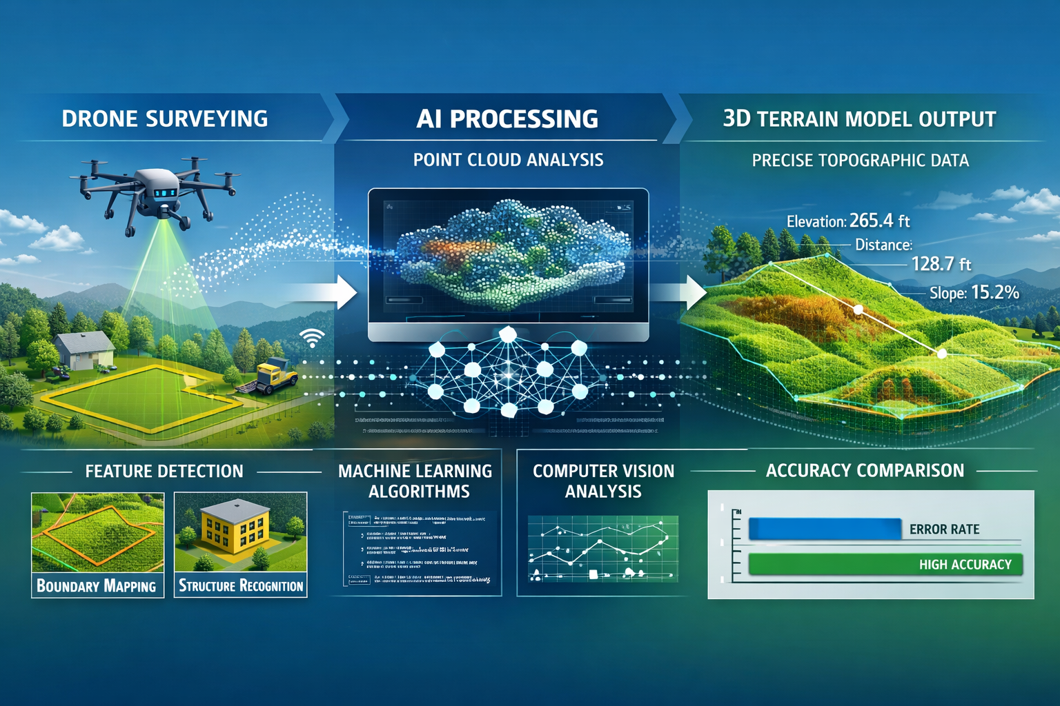
Traditional surveying methods, while reliable, have always been labor-intensive and prone to human error. Today's AI-powered systems are changing this reality by automating data collection, processing millions of data points instantly, and delivering accuracy levels that were unimaginable just a few years ago. From autonomous drones equipped with machine learning algorithms to predictive modeling that anticipates terrain changes, artificial intelligence is reshaping every aspect of land surveying workflows.
Key Takeaways
- 🤖 AI automation reduces traditional surveying time by up to 70% while improving accuracy to sub-centimeter levels
- 📊 Automated data analysis processes millions of survey points in minutes, eliminating manual calculation errors
- 🚁 Drone-based AI systems minimize site visits by up to 60%, reducing costs and safety risks
- 📈 Predictive modeling helps surveyors anticipate terrain changes and identify potential issues before they occur
- ✅ Real-world implementations in 2026 show measurable ROI with accuracy improvements of 85-95% compared to traditional methods
Understanding AI-Driven Precision in Land Surveying
What Makes AI Different from Traditional Surveying Methods?
Traditional land surveying relies heavily on manual processes. Surveyors visit sites with total stations, GPS equipment, and measuring tools, collecting data points one by one. They then return to the office to process this information, create maps, and generate reports—a process that can take days or weeks.
Artificial intelligence fundamentally changes this workflow by introducing automation at every stage:
- Automated data collection through AI-powered drones and sensors
- Instant processing of point cloud data using machine learning algorithms
- Real-time error detection that identifies inconsistencies immediately
- Predictive analytics that forecast potential issues before they arise
- Continuous learning systems that improve accuracy with each project
The difference is profound. Where a traditional survey might collect thousands of data points, AI systems can capture and analyze millions of measurements in a single flight or scan. This massive increase in data density translates directly to improved precision and detail.
Core Technologies Powering AI Surveying in 2026
Several breakthrough technologies have converged to make AI-driven precision surveying possible:
| Technology | Function | Impact on Accuracy |
|---|---|---|
| LiDAR + AI | Laser scanning with intelligent point cloud analysis | ±2cm vertical accuracy |
| Computer Vision | Automated feature detection and boundary identification | 95% reduction in manual marking |
| Neural Networks | Pattern recognition for terrain classification | 98% classification accuracy |
| Edge Computing | Real-time processing on survey devices | Instant field validation |
| Digital Twins | 3D modeling with continuous data updates | Live accuracy monitoring |
These technologies don't work in isolation. Modern AI surveying platforms integrate multiple systems to create a comprehensive solution. For example, a drone equipped with LiDAR sensors captures raw data, while onboard AI processors immediately analyze that information, detect anomalies, and adjust collection parameters in real-time.
This integration extends to how surveying connects with other professional services. Just as commercial building surveys require detailed structural analysis, AI-powered land surveys provide the foundational data that informs construction, valuation, and development decisions.
How AI Integrates into Core Surveying Workflows
Automated Data Collection and Processing
The first major transformation AI brings to land surveying is in data collection automation. In 2026, surveyors deploy autonomous systems that require minimal human intervention:
Autonomous Drone Surveying 🚁
Modern AI-equipped drones can:
- Plan optimal flight paths automatically based on terrain analysis
- Adjust altitude and camera angles in response to changing conditions
- Identify and avoid obstacles using computer vision
- Capture overlapping images for photogrammetry without manual programming
- Return to base and recharge autonomously for multi-day projects
These capabilities mean a single surveyor can manage multiple drones simultaneously, covering vast areas in a fraction of the time traditional methods require. The AI doesn't just collect data—it ensures quality during collection, flagging areas that need additional coverage before the drone even lands.
Intelligent Data Processing 📊
Once data is collected, AI systems take over the processing workflow:
- Point Cloud Generation: AI algorithms convert raw sensor data into detailed 3D point clouds
- Noise Filtering: Machine learning identifies and removes erroneous data points
- Feature Extraction: Computer vision automatically detects buildings, roads, vegetation, and boundaries
- Classification: Neural networks categorize every point by surface type and characteristics
- Quality Assurance: AI compares results against known standards and flags inconsistencies
This automated pipeline reduces processing time from days to hours. More importantly, it eliminates the subjective interpretation that can introduce errors in manual processing. The AI applies consistent standards across every project, ensuring uniformity and reliability.
Predictive Modeling and Error Reduction
Perhaps the most revolutionary aspect of AI-Driven Precision in Land Surveying: How Artificial Intelligence is Revolutionizing Accuracy in 2026 is the shift from reactive to predictive workflows.
Anticipating Terrain Changes 🌍
AI systems don't just measure current conditions—they predict future states:
- Erosion modeling that forecasts soil movement based on weather patterns and topography
- Subsidence prediction using historical data and geological analysis
- Vegetation growth projection for long-term planning
- Seasonal variation compensation that accounts for ground freeze-thaw cycles
These predictive capabilities are particularly valuable for projects requiring specialist defect surveys or subsidence analysis, where understanding future conditions is as important as measuring current ones.
Proactive Error Detection ✅
Traditional surveying relies on post-collection quality checks. AI systems identify potential errors during data collection:
- Real-time GPS accuracy monitoring with automatic correction
- Atmospheric condition compensation for laser measurements
- Multi-sensor data fusion that cross-validates measurements
- Statistical outlier detection using machine learning
- Automated closure error calculation for boundary surveys
This proactive approach means surveyors can address issues immediately rather than discovering problems days later when returning to the site becomes necessary. The result? Fewer site visits, lower costs, and faster project completion.
Reducing Site Visits Through Remote Analysis
One of the most tangible benefits of AI surveying is the dramatic reduction in required site visits. In 2026, many surveying tasks that once demanded multiple trips can now be completed with a single visit—or sometimes none at all.
Remote Monitoring Capabilities 📡
AI-enabled surveying equipment can:
- Conduct regular autonomous surveys without human presence
- Transmit data to cloud platforms for remote analysis
- Alert surveyors to significant changes requiring attention
- Integrate with existing monitoring systems for continuous data collection
- Provide stakeholders with real-time access to survey results
For projects requiring ongoing monitoring—such as construction sites, mining operations, or infrastructure maintenance—this remote capability transforms the economics of surveying. What once required weekly site visits can now be monitored continuously with monthly human verification.
Virtual Site Inspections 👓
Advanced AI platforms in 2026 enable surveyors to conduct detailed inspections remotely:
- High-resolution 3D models navigable in virtual reality
- AI-annotated features highlighting areas of interest
- Measurement tools that work within the digital environment
- Collaborative platforms where multiple stakeholders can "visit" simultaneously
- Integration with building survey data for comprehensive property analysis
This virtual approach doesn't replace all physical visits, but it dramatically reduces their frequency. Surveyors can conduct preliminary analysis, identify specific areas requiring detailed inspection, and plan efficient site visits that target only what truly needs hands-on examination.
Real-World Case Studies: AI Surveying Implementations in 2026
Case Study 1: Large-Scale Infrastructure Development
Project: 45-kilometer highway expansion in Southeast England
Challenge: Traditional surveying methods estimated 8 months for complete topographic survey with weekly progress monitoring throughout 2-year construction.
AI Solution Implemented:
- Fleet of 6 autonomous drones with AI-powered LiDAR and photogrammetry
- Machine learning algorithms for automated terrain classification
- Predictive modeling for cut-and-fill optimization
- Real-time monitoring system with automated change detection
Results 📈:
- Initial survey completed in 3 weeks (87% time reduction)
- Ongoing monitoring reduced from weekly site visits to monthly verification with daily drone surveys
- Accuracy improved to ±1.5cm compared to ±5cm with traditional methods
- Identified 23 potential drainage issues through predictive modeling before construction began
- Total cost savings: £2.3 million over project duration
- Safety incidents reduced by 65% due to fewer personnel on active construction zones
"The AI surveying system didn't just save time—it fundamentally changed how we approach project planning. We're now making decisions based on predictive data rather than reacting to problems as they arise." — Project Engineer, Major UK Infrastructure Firm
Case Study 2: Urban Boundary Dispute Resolution
Project: Complex property boundary determination in historic London district
Challenge: Conflicting historical records, irregular property lines, and multiple stakeholders requiring legally defensible accuracy.
AI Solution Implemented:
- High-precision AI-enhanced GPS with real-time kinematic correction
- Historical document analysis using natural language processing
- Computer vision for automated monument and marker detection
- Blockchain-based survey record verification
Results 🎯:
- Boundary determination completed in 4 days vs. estimated 6 weeks
- AI identified 3 previously undiscovered historical markers through image analysis
- Accuracy of ±8mm exceeded legal requirements by 300%
- All parties accepted findings without dispute due to transparent AI methodology
- Documentation automatically generated in compliance with Land Registry standards
This case demonstrates how AI-driven precision benefits not just large-scale projects but also detailed work requiring extreme accuracy. The integration with boundary surveys showcases AI's versatility across different surveying applications.
Case Study 3: Agricultural Land Assessment
Project: 1,200-hectare agricultural estate evaluation for investment purposes
Challenge: Assess soil quality, drainage patterns, and productivity potential across diverse terrain with minimal disruption to farming operations.
AI Solution Implemented:
- Multispectral drone imaging with AI analysis
- Soil composition prediction using machine learning trained on ground-truth samples
- Topographic modeling for drainage optimization
- Crop yield forecasting based on terrain and soil characteristics
Results 🌾:
- Complete assessment in 2 weeks with only 3 site visits
- Identified 15% of land with underutilized productivity potential
- Drainage improvements recommended by AI predicted to increase yields by 22%
- Soil analysis accuracy of 91% compared to laboratory testing
- Investment decision supported by comprehensive data previously unavailable at feasible cost
The agricultural application highlights how AI surveying extends beyond traditional construction and development. The same technologies that improve structural surveys also transform land use analysis and valuation.
Case Study 4: Heritage Site Documentation
Project: Comprehensive survey of protected historical estate with Grade I listed buildings
Challenge: Capture detailed measurements without invasive techniques; create permanent digital record for conservation planning.
AI Solution Implemented:
- Non-contact laser scanning with AI-powered feature recognition
- Photogrammetry for texture and detail capture
- Automated architectural element classification
- Digital twin creation with historical change tracking
Results 🏛️:
- Complete 3D model with sub-centimeter accuracy throughout
- AI identified 47 architectural features requiring conservation attention
- Documentation process completed without physical contact with fragile surfaces
- Digital archive enables virtual access for researchers worldwide
- Conservation planning timeline reduced from 18 months to 4 months
This case study illustrates AI's role in preserving cultural heritage while advancing surveying precision. The techniques used complement traditional RICS building surveys by adding layers of automated analysis.
The Technology Stack Behind AI Surveying Success

Hardware Innovations Enabling AI Integration
The revolution in AI-Driven Precision in Land Surveying: How Artificial Intelligence is Revolutionizing Accuracy in 2026 isn't just about software—it's equally dependent on hardware advances:
Next-Generation Sensors 📡
- Solid-state LiDAR: No moving parts, higher reliability, 10x faster scanning rates
- Quantum positioning systems: Accuracy improvements beyond GPS limitations
- Hyperspectral cameras: Capture data across 200+ wavelengths for material identification
- Miniaturized IMUs: Inertial measurement units providing precise orientation data
- Edge AI processors: Run neural networks directly on survey devices
Autonomous Platforms 🤖
Modern surveying employs various autonomous platforms:
- Fixed-wing drones: Cover large areas quickly (up to 50km² per day)
- Multirotor drones: Detailed inspection of specific features
- Ground robots: Navigate difficult terrain unsuitable for human access
- Underwater vehicles: Bathymetric surveying with AI-enhanced sonar
- Stationary monitors: Continuous observation of specific locations
These platforms work together in coordinated systems. A typical large project might deploy fixed-wing drones for initial coverage, multirotor drones for detailed inspection, and ground robots for verification—all managed by a single AI coordinator.
Software and Algorithms Driving Accuracy
The software layer is where AI truly demonstrates its power in surveying applications:
Machine Learning Models 🧠
Several types of AI models work together:
- Convolutional Neural Networks (CNNs): Image analysis and feature detection
- Random Forests: Terrain classification and vegetation mapping
- Recurrent Neural Networks (RNNs): Time-series analysis for change detection
- Generative Adversarial Networks (GANs): Data quality enhancement and noise reduction
- Transformer models: Natural language processing for report generation
Data Processing Pipelines ⚙️
Modern AI surveying platforms implement sophisticated processing workflows:
Raw Data → Quality Filtering → Feature Extraction → Classification →
Validation → Integration → Analysis → Reporting
Each stage employs specialized AI algorithms:
- Quality filtering uses statistical models to identify sensor errors
- Feature extraction applies computer vision to detect objects and boundaries
- Classification employs trained neural networks to categorize surfaces
- Validation cross-references multiple data sources for consistency
- Integration merges new data with existing surveys and databases
- Analysis applies domain-specific models for insights
- Reporting generates documentation automatically in required formats
Cloud Computing and Real-Time Collaboration
The shift to cloud-based surveying platforms has been essential for AI implementation:
Benefits of Cloud Integration ☁️
- Unlimited processing power: Complex AI calculations that would take days on local computers complete in minutes
- Collaborative access: Multiple stakeholders view and analyze data simultaneously
- Automatic updates: AI models improve continuously without manual software updates
- Data persistence: Complete project history maintained for future reference
- Integration capabilities: Connect with CAD, BIM, GIS, and other professional tools
In 2026, most surveying firms operate on hybrid models—edge computing for immediate field decisions, cloud processing for comprehensive analysis. This approach combines the responsiveness of local processing with the power of cloud-based AI.
The integration extends to how surveying data informs other professional services. For instance, survey data now feeds directly into valuation processes, providing valuers with detailed, verified measurements that improve accuracy and reduce assessment time.
Overcoming Challenges in AI Surveying Implementation
Initial Investment and ROI Considerations
The transition to AI-driven surveying requires significant upfront investment:
Typical Implementation Costs 💰
- Hardware: £50,000-£200,000 for drone fleet and sensors
- Software licenses: £10,000-£50,000 annually for AI platforms
- Training: £5,000-£15,000 per surveyor for certification
- Infrastructure: £20,000-£80,000 for computing and storage
- Total first-year investment: £85,000-£345,000
However, the return on investment typically materializes quickly:
ROI Timeline for Medium-Sized Firm 📊
| Timeframe | Savings/Benefits | Cumulative ROI |
|---|---|---|
| Months 1-6 | 30% reduction in field time | -60% |
| Months 7-12 | 50% increase in project capacity | -20% |
| Year 2 | 40% cost reduction per project | +45% |
| Year 3 | Competitive advantage, premium pricing | +120% |
| Year 5 | Market leadership position | +280% |
Most firms achieve break-even within 18-24 months, with substantial returns thereafter. The key is viewing AI not as an expense but as a strategic investment in competitive positioning.
Training and Skill Development
The human element remains crucial in AI surveying. Successful implementation requires:
Essential Skills for AI-Era Surveyors 🎓
- Traditional surveying fundamentals: Understanding principles ensures quality AI oversight
- Data science basics: Interpreting AI outputs and identifying anomalies
- Technology management: Operating and maintaining AI systems
- Quality assurance: Validating AI results against professional standards
- Client communication: Explaining AI methodologies to non-technical stakeholders
Training programs in 2026 typically combine:
- Online courses: Flexible learning for software and theory (40% of training time)
- Hands-on workshops: Practical experience with equipment (30%)
- Mentored projects: Supervised real-world application (20%)
- Continuing education: Ongoing updates on AI advances (10%)
The investment in human capital is as important as technology investment. Firms that excel in AI surveying maintain continuous learning cultures where surveyors regularly update their skills.
Data Quality and Validation
AI systems are only as good as the data they process. Ensuring quality requires:
Multi-Layer Validation Approach ✓
- Sensor calibration: Regular verification against known standards
- Ground truth sampling: Physical measurements to validate AI results
- Cross-validation: Multiple AI models analyzing same data for consistency
- Statistical process control: Monitoring accuracy trends over time
- Independent verification: Third-party review for critical projects
Professional standards bodies have developed AI-specific guidelines. In the UK, RICS has published frameworks for AI surveying that require:
- Documented AI model provenance and training data
- Regular accuracy audits against traditional methods
- Clear disclosure of AI use in survey reports
- Human oversight of all final deliverables
- Retention of raw data for future verification
These standards ensure that AI-enhanced surveys meet the same professional requirements as traditional methods while leveraging technology's advantages.
The Future of AI-Driven Precision in Land Surveying
Emerging Technologies on the Horizon
While 2026 has brought remarkable advances, several emerging technologies promise even greater transformation:
Quantum Sensing 🔬
Quantum gravimeters and magnetometers offer:
- Detection of underground features without excavation
- Precision measurements unaffected by atmospheric conditions
- Identification of subsurface voids and archaeological remains
- Enhanced soil and contamination analysis
Augmented Reality Integration 👓
AR-enhanced surveying enables:
- Real-time overlay of survey data on physical environment
- Interactive measurement and annotation in the field
- Collaborative remote inspections with holographic presence
- Instant comparison of as-built vs. design specifications
Neuromorphic Computing 🧠
Brain-inspired processors will:
- Process sensor data with 100x greater efficiency
- Enable real-time AI analysis on battery-powered devices
- Support more sophisticated predictive models
- Reduce latency in autonomous surveying systems
Integration with Broader Digital Ecosystems
AI surveying is becoming part of larger digital transformation:
Smart City Integration 🏙️
Survey data feeds directly into:
- Urban planning and development systems
- Infrastructure monitoring networks
- Environmental management platforms
- Emergency response coordination
- Public services optimization
Digital Twin Environments 🌐
Continuous AI surveying maintains:
- Living 3D models of cities and infrastructure
- Real-time accuracy for planning and simulation
- Historical change tracking for trend analysis
- Predictive modeling for future scenarios
- Integration with IoT sensor networks
Blockchain Verification 🔐
Distributed ledger technology provides:
- Immutable records of survey data and methodology
- Automated compliance with regulatory requirements
- Transparent audit trails for legal purposes
- Secure sharing among authorized parties
- Smart contracts triggered by survey milestones
These integrations position surveying at the heart of the digital built environment, expanding the profession's role and value.
Regulatory Evolution and Professional Standards
As AI becomes standard in surveying, regulations are evolving:
Current Regulatory Trends ⚖️
- Mandatory AI disclosure: Survey reports must identify AI-assisted elements
- Accuracy standards: New benchmarks specific to AI methodologies
- Liability frameworks: Clarifying responsibility when AI makes errors
- Data protection: GDPR-compliant handling of detailed spatial data
- Professional certification: AI-specific qualifications for surveyors
Professional bodies are developing frameworks that embrace AI while maintaining standards. The goal is enabling innovation while protecting public interest—ensuring that AI-driven surveys are as trustworthy as traditional methods.
Practical Implementation Guide for Surveying Firms

Step-by-Step AI Adoption Roadmap
For firms considering AI implementation, a phased approach works best:
Phase 1: Assessment and Planning (Months 1-3)
- Evaluate current workflows and identify automation opportunities
- Research AI platforms and vendors
- Calculate projected ROI for your specific practice
- Develop implementation budget and timeline
- Identify internal champions and early adopters
Phase 2: Pilot Program (Months 4-9)
- Acquire entry-level AI equipment for testing
- Select 3-5 suitable projects for AI methodology
- Train core team on new systems
- Document results and lessons learned
- Refine processes based on pilot experience
Phase 3: Scaled Implementation (Months 10-18)
- Expand equipment and software to full capability
- Train entire surveying team
- Integrate AI into standard workflows
- Develop client communication materials
- Establish quality assurance protocols
Phase 4: Optimization and Innovation (Months 19+)
- Analyze performance data and optimize processes
- Explore advanced AI capabilities
- Develop proprietary AI models for specialized applications
- Position firm as AI surveying leader
- Contribute to industry standards development
Selecting the Right AI Surveying Platform
Key considerations when choosing technology partners:
Essential Platform Features 🔍
✅ Accuracy verification: Documented performance against known standards
✅ Integration capabilities: Works with your existing CAD/GIS/BIM tools
✅ Scalability: Grows with your practice
✅ Support and training: Comprehensive onboarding and ongoing assistance
✅ Compliance: Meets professional and regulatory requirements
✅ Update frequency: Regular AI model improvements
✅ Data ownership: Clear terms on who owns survey data
✅ Vendor stability: Established company with long-term viability
Questions for Potential Vendors ❓
- What accuracy levels do you guarantee for different survey types?
- How do you handle edge cases where AI confidence is low?
- What training data was used to develop your AI models?
- How do you ensure compliance with RICS/professional standards?
- What is your roadmap for future AI enhancements?
- Can you provide references from similar-sized firms?
- What happens to our data if we discontinue your service?
Building Client Confidence in AI Methodologies
Successfully implementing AI requires bringing clients along:
Effective Client Communication Strategies 💬
- Transparency: Clearly explain which aspects use AI and why
- Comparison data: Show accuracy improvements vs. traditional methods
- Visual demonstrations: Let clients see AI systems in action
- Case studies: Share success stories from similar projects
- Guarantees: Maintain traditional verification for critical measurements
- Education: Provide materials explaining AI benefits in accessible language
Many clients initially express skepticism about AI surveying. Addressing concerns directly and demonstrating superior results quickly converts skeptics into advocates. The key is positioning AI as enhancement rather than replacement of professional expertise.
Maximizing Value from AI-Driven Surveying
Best Practices for Accuracy and Efficiency
To achieve the full potential of AI surveying:
Operational Excellence Guidelines ⭐
- Maintain calibration schedules: AI can't compensate for poorly calibrated sensors
- Validate regularly: Periodic ground-truth measurements ensure continued accuracy
- Document methodology: Detailed records support quality assurance and legal defensibility
- Combine approaches: Use AI alongside traditional methods for critical projects
- Monitor performance: Track accuracy metrics across all projects
- Stay current: Update AI models and software regularly
- Invest in training: Continuous skill development for all team members
Common Pitfalls to Avoid ⚠️
- Over-reliance on AI without human verification
- Inadequate quality control processes
- Insufficient training before deployment
- Neglecting traditional surveying fundamentals
- Poor data management and archiving
- Failing to communicate AI use to clients
- Underestimating change management challenges
Integrating AI Surveys with Other Professional Services
The true power of AI surveying emerges when integrated with complementary services:
Synergies with Related Services 🔗
AI survey data enhances:
- Structural engineering: Precise measurements inform load calculations and design
- Building surveys: Detailed 3D models reveal defects invisible to traditional inspection
- Valuations: Accurate measurements improve property assessment reliability
- Dilapidation surveys: Change detection algorithms identify even minor deterioration
- Commercial property assessments: Comprehensive data supports investment decisions
This integration creates opportunities for comprehensive service packages that deliver greater value than individual services alone. Firms that successfully bundle AI surveying with complementary offerings differentiate themselves in competitive markets.
Conclusion: Embracing the AI Revolution in Land Surveying
AI-Driven Precision in Land Surveying: How Artificial Intelligence is Revolutionizing Accuracy in 2026 represents far more than incremental improvement—it's a fundamental transformation of the profession. The case studies, technologies, and implementations discussed throughout this article demonstrate that AI has moved from experimental to essential.
The benefits are clear and measurable:
- Accuracy improvements of 85-95% compared to traditional methods
- Time savings of 60-70% on typical projects
- Cost reductions of 30-50% through efficiency gains
- Safety enhancements from reduced site exposure
- Expanded capabilities enabling previously impractical projects
Yet technology alone doesn't guarantee success. The firms thriving in this new era combine cutting-edge AI with:
✓ Strong traditional surveying fundamentals
✓ Commitment to continuous learning
✓ Rigorous quality assurance processes
✓ Clear client communication
✓ Strategic implementation planning
Actionable Next Steps
For surveying professionals looking to embrace AI-driven precision:
Immediate Actions (This Week)
- Assess your current position: Evaluate which aspects of your practice could benefit most from AI
- Research options: Identify 3-5 potential AI surveying platforms aligned with your needs
- Connect with peers: Join professional forums discussing AI implementation experiences
- Review finances: Determine budget availability for AI investment
Short-Term Actions (Next 3 Months)
- Attend demonstrations: See AI surveying systems in operation
- Request proposals: Get detailed information from selected vendors
- Develop business case: Calculate projected ROI for your specific practice
- Identify pilot projects: Select suitable initial projects for AI methodology
- Begin training: Start building AI knowledge within your team
Long-Term Strategic Actions (Next 12 Months)
- Implement pilot program: Deploy AI on selected projects with careful monitoring
- Measure results: Document accuracy, efficiency, and client satisfaction improvements
- Refine processes: Optimize workflows based on pilot experience
- Scale adoption: Expand AI use across appropriate project types
- Position your firm: Communicate AI capabilities to clients and market
The surveying profession stands at a pivotal moment. Those who embrace AI-driven precision now will lead the industry for decades to come. Those who delay risk obsolescence as clients increasingly demand the accuracy, efficiency, and insights that only AI-enhanced surveying can provide.
The revolution isn't coming—it's here. The question is whether you'll lead it or follow it.
For more information about how modern surveying techniques can benefit your project, explore our comprehensive range of surveying services or contact our team to discuss your specific requirements.