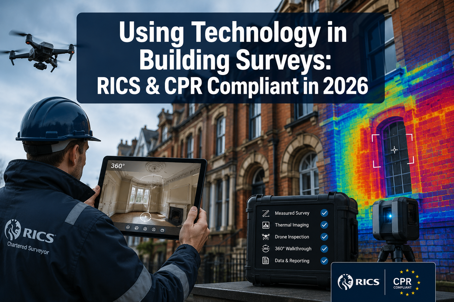
Fewer than one in five building surveyors reported using drone footage as standard practice five years ago. In 2026, that figure has shifted dramatically, and with it comes a new layer of professional responsibility. Using technology in 2026 building surveys without breaching RICS and CPR expectations around photos, video walkthroughs and site data is no longer an optional consideration — it is a core competency that separates defensible, high-quality reports from those that expose practitioners to professional and legal risk.
This article offers practical guidance on how chartered surveyors can deploy high-resolution photography, 360-degree video tours, drone footage, thermal imaging, and digital measurement tools to produce richer, more accurate reports — while remaining fully compliant with RICS professional standards and the Civil Procedure Rules (CPR) that govern expert witness evidence.
Key Takeaways
- RICS introduced a formal professional standard on responsible AI use in March 2026, confirming that technology must support, not replace, professional judgement [2]
- High-resolution photography, drone footage, and thermal imaging are now included in RICS equipment guidance for home surveys [8]
- Digital data capture tools can reduce on-site survey time by up to 70%, but data integrity and chain of custody remain critical [5]
- CPR Part 35 requires that expert evidence — including photographic and video records — is objective, reproducible, and clearly attributed
- Cybersecurity and data privacy obligations apply to all digitally captured site data, including images stored in cloud environments [7]
Why Technology Compliance Matters in 2026 Building Surveys
The integration of digital tools into building surveys has accelerated faster than the regulatory frameworks designed to govern them. RICS has responded with updated guidance, and in March 2026 it published a formal professional standard on the responsible use of artificial intelligence in surveying [2]. The core message is clear: technology is a tool that enhances professional output, not a substitute for the qualified judgement of a chartered surveyor.
For surveyors producing reports that may be used in litigation, insurance claims, or dispute resolution, the CPR framework adds a second layer of obligation. Under CPR Part 35, expert evidence must be impartial, reproducible, and presented in a way that assists the court. Photographic evidence, video walkthroughs, and digitally captured measurements all fall within this scope. A drone video that cannot be authenticated, or a thermal image without calibration data, may be challenged and excluded.
Understanding this dual compliance environment — RICS standards on one side, CPR expectations on the other — is the foundation for using technology in 2026 building surveys without breaching RICS and CPR expectations around photos, video walkthroughs and site data.
What RICS Expects From Technology-Assisted Surveys
RICS guidance is explicit that digital tools must produce outputs that are accurate, reliable, and professionally interpreted. The RICS equipment checklist for home surveys recommends digital cameras, thermal imaging devices, and drones as standard tools [8]. However, the checklist also emphasises that the surveyor remains responsible for the interpretation of all outputs.
Key RICS expectations include:
- Equipment must be appropriate for the task and properly calibrated
- Digital outputs must be clearly labelled, dated, and attributed
- AI-assisted analysis must be reviewed and validated by a qualified professional [1]
- Reports must distinguish between observed evidence and inferred conclusions
For RICS building surveys, this means that a photograph of a crack is evidence, but the surveyor's written assessment of its cause and severity is the professional product. Technology captures the data; expertise interprets it.
Photography and Video Walkthroughs: Best Practice for Compliance
High-Resolution Photography as Evidence
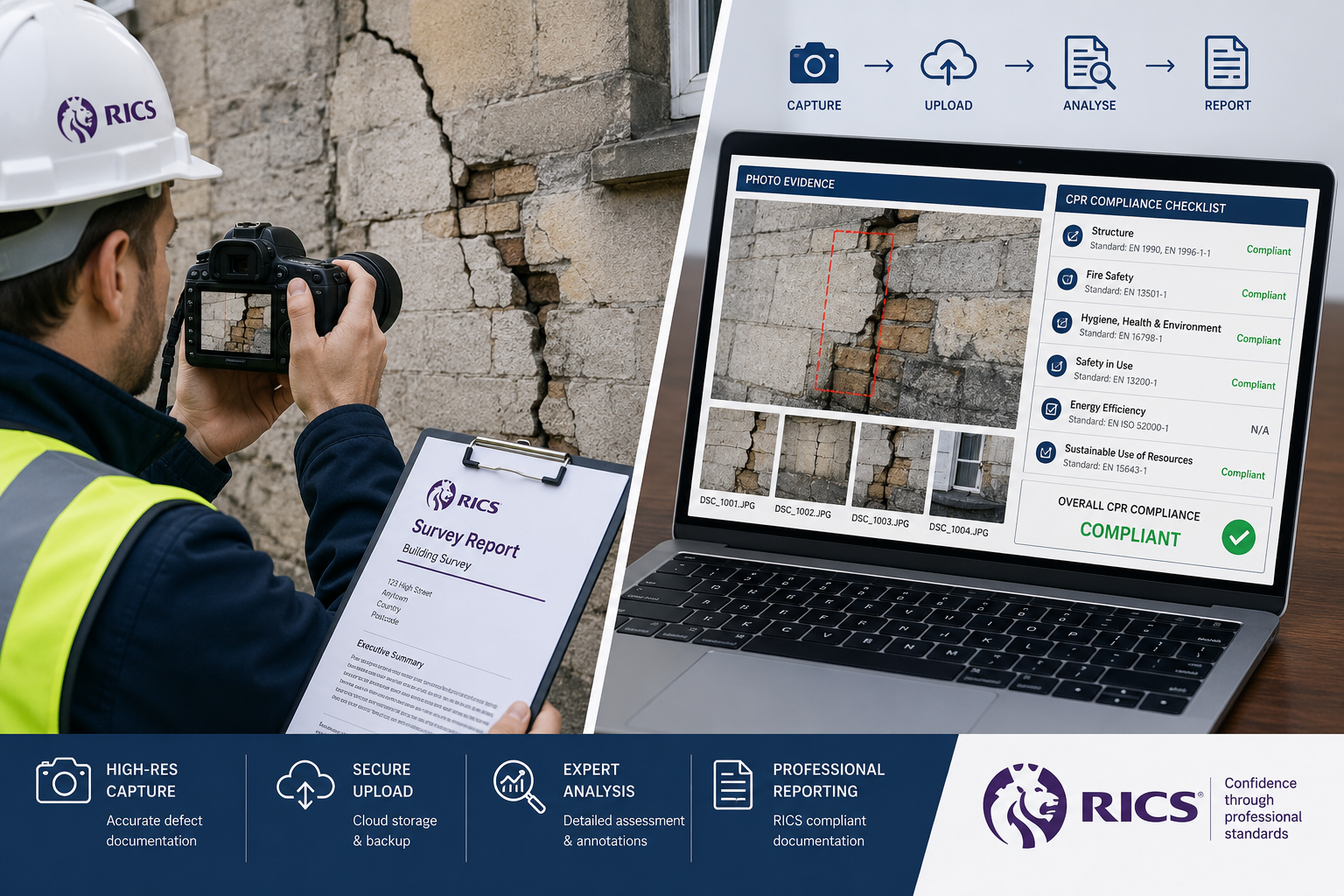
Photographic evidence is the most commonly used technology in building surveys, yet it is also the most frequently misused. A photograph without metadata — including date, time, GPS coordinates, and camera settings — has limited evidential value in a disputed matter.
Best practice for compliant photography in 2026:
| Requirement | Why It Matters |
|---|---|
| Embedded EXIF metadata | Confirms date, time, and device used |
| Geotagging | Places the image at the correct property |
| Sequential file naming | Demonstrates chain of custody |
| Scale reference in frame | Allows accurate size assessment |
| Consistent lighting conditions | Prevents misrepresentation of defect severity |
For structural surveys and dilapidation surveys, photographs should be taken before, during, and after any investigation. This creates a defensible chronological record that supports both the survey report and any subsequent expert witness statement.
360-Degree Video Walkthroughs
360-degree cameras have become a practical tool for capturing interior conditions at the time of inspection. A complete video walkthrough of a property provides a contemporaneous record that is difficult to dispute. For schedule of condition reports, this is particularly valuable — the walkthrough becomes a timestamped baseline against which future dilapidations claims can be assessed.
CPR compliance requires that video evidence is:
- Unedited or, if edited, clearly labelled as such with an explanation
- Accompanied by a written log that cross-references footage to specific defects noted in the report
- Stored securely and made available to all parties on request
"The video walkthrough does not replace the written report — it corroborates it. The surveyor's professional judgement remains the primary product."
Digital data capture applications such as GoReport allow surveyors to link photographs and voice notes directly to specific sections of a report template on-site. This approach has been shown to reduce survey administration time by up to 70% compared to traditional paper-based methods [5]. Critically, it also creates a structured, auditable data trail that supports CPR compliance.
Drones, LiDAR and Thermal Imaging: Advanced Tools and Their Obligations
Drone Surveys: Capability and Compliance
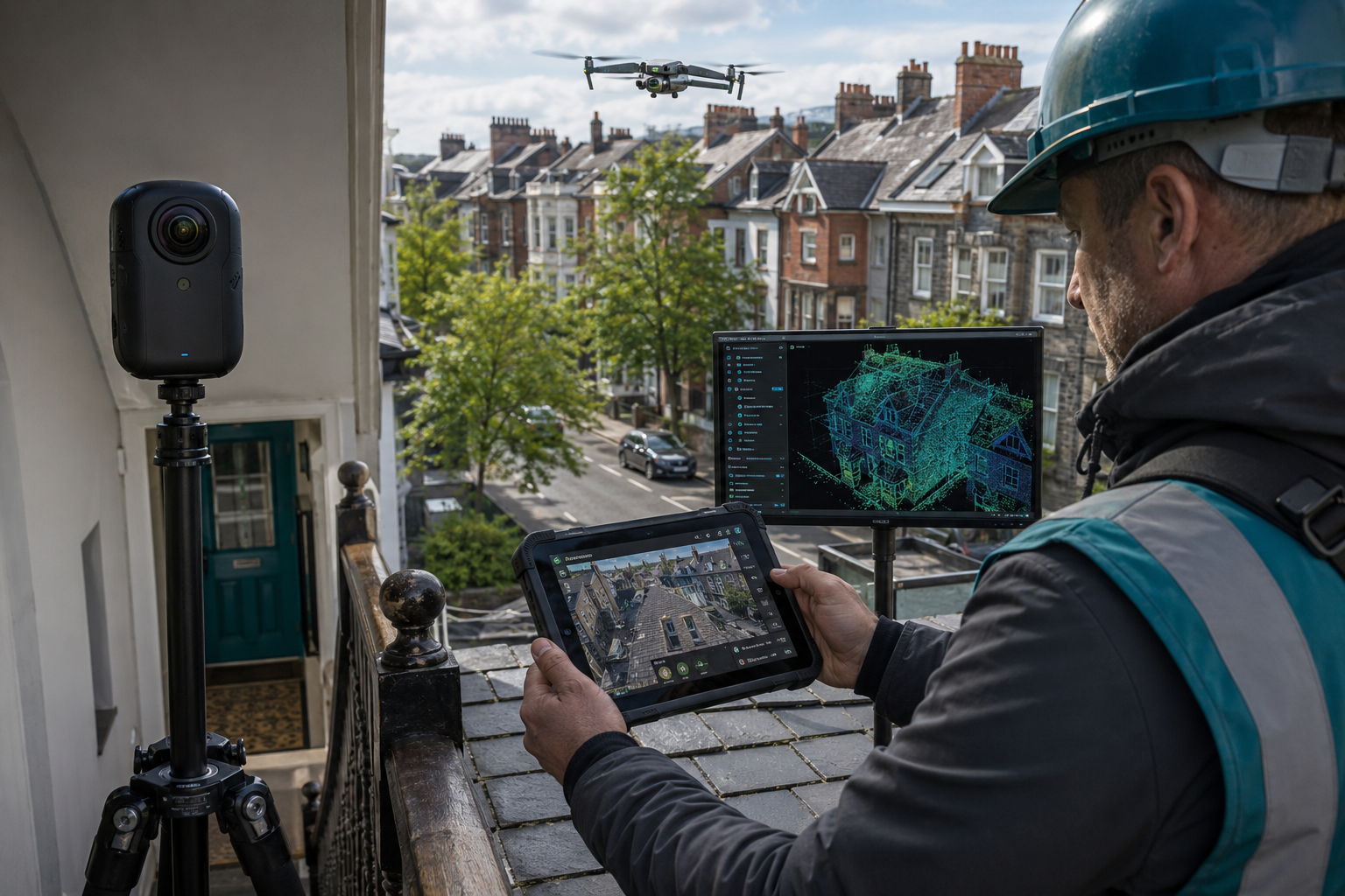
Drones have become essential equipment for inspecting roofs, high-level facades, and other areas that would otherwise require scaffolding or specialist access equipment [3]. For roof surveys in particular, drone footage provides high-resolution imagery of ridge tiles, flashings, gutters, and chimney stacks without placing the surveyor at risk.
However, drone use in 2026 carries specific obligations:
- Civil Aviation Authority (CAA) registration is required for most commercial drone operations
- Permission from the property owner and, where relevant, neighbouring landowners must be obtained before flight
- Data protection compliance under UK GDPR applies to any footage that captures identifiable individuals or third-party properties
- Flight logs must be maintained and made available on request
From a RICS perspective, drone footage must be treated as raw data. The surveyor must review the footage, identify relevant defects, and record professional observations in the written report. The footage itself supports the findings but does not replace them.
LiDAR and Measured Survey Data
Light Detection and Ranging (LiDAR) technology creates precise three-dimensional models of existing structures by emitting laser pulses and measuring their return time [4]. In 2026, LiDAR is increasingly accessible through both dedicated scanning equipment and smartphone-integrated sensors.
For refurbishment projects, conservation work, and planning applications, LiDAR-generated floor plans and elevations provide a level of dimensional accuracy that hand measurements cannot match. When integrated with Building Information Modelling (BIM) workflows, this data supports the entire building lifecycle [4].
For CPR purposes, LiDAR data must be:
- Captured using calibrated equipment with a known margin of error
- Processed using documented software with version records
- Presented with a clear statement of accuracy in the survey report
Measured building surveys that use laser scanning and total stations are now considered standard for complex or historic structures [9]. Surveyors undertaking monitoring surveys for subsidence or structural movement will find LiDAR particularly valuable for establishing precise baseline measurements.
Thermal Imaging: Protocols That Protect Findings
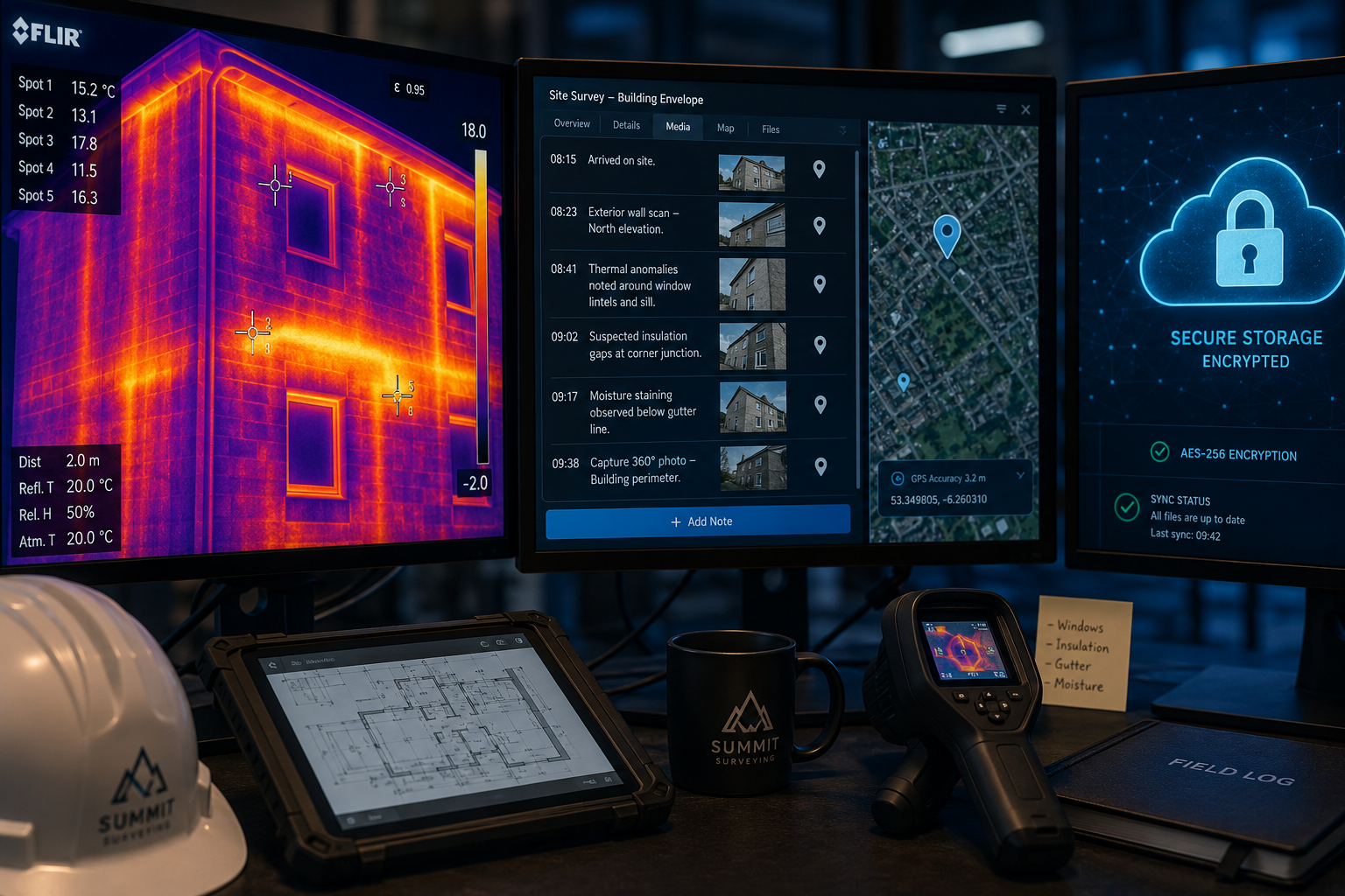
Thermal imaging cameras detect infrared radiation to identify insulation defects, cold bridges, moisture intrusion, and heat loss [6]. The technology is powerful, but its outputs are highly sensitive to environmental conditions. A thermographic survey conducted in the wrong conditions can produce misleading results that, if cited in a report, expose the surveyor to challenge.
RICS guidance on thermographic surveys specifies [6]:
- A minimum temperature differential of 10°C between inside and outside the building
- Surveys should be conducted at night or in overcast conditions to avoid solar gain distortion
- Equipment must be calibrated and the emissivity setting adjusted for the material being measured
- Results should be cross-referenced with moisture meter readings where damp is suspected
For Level 2 homebuyer surveys and commercial building surveys, thermal imaging adds significant diagnostic value when used correctly. When used incorrectly, it creates liability.
Managing Site Data: Storage, Security and Professional Accountability
Data Integrity and Chain of Custody
The evidential value of any digitally captured data depends entirely on its integrity. For survey data to be admissible and defensible — whether in a RICS professional standards review or a CPR-governed dispute — the following must be demonstrable:
- Who captured the data (surveyor name, qualifications, role)
- When it was captured (timestamped at point of collection)
- Where it was captured (geotagged or cross-referenced to site plan)
- How it has been stored (secure, access-controlled, backed up)
- Whether it has been altered (version history and audit trail)
Cloud-based survey platforms increasingly offer these features as standard. However, surveyors must verify that their chosen platform complies with UK GDPR, stores data on UK or EEA servers, and provides audit logs that can be exported for disclosure.
Cybersecurity Obligations
As building surveys generate more digital data, the risk of that data being compromised increases. RICS has highlighted cybersecurity as a growing concern for property professionals, noting that client data held on surveyor systems is a target for hostile actors [7]. The consequences of a data breach extend beyond reputational damage — they include potential regulatory action under UK GDPR and professional conduct proceedings under RICS rules.
Practical cybersecurity measures for surveyors in 2026 include:
- Encrypted storage for all site photographs, videos, and measurement data
- Multi-factor authentication on all survey software and cloud accounts
- Clear data retention and deletion policies aligned with client instructions
- Contractual data processing agreements with any third-party software providers [10]
The digital risks associated with building data are not hypothetical — they are an active professional obligation [10]. Surveyors who collect extensive site data using advanced technology must apply the same rigour to its protection as they do to its collection.
AI-Assisted Analysis: Where Human Oversight Is Non-Negotiable
Machine learning and computer vision tools can now analyse photographic and video data to flag potential defects — cracks, damp staining, incomplete installations — with increasing accuracy [1]. In 2026, several survey platforms offer AI-assisted defect detection as a built-in feature.
RICS is explicit that AI outputs must be reviewed and validated by a qualified professional before inclusion in any report [2]. The surveyor cannot delegate professional responsibility to an algorithm. Where AI tools are used, the report should:
- Disclose that AI-assisted analysis was employed
- Confirm that all AI-flagged items were reviewed by the named surveyor
- State the surveyor's independent professional conclusion on each flagged item
This approach satisfies both RICS professional standards and CPR requirements for expert evidence — the human expert remains accountable for every conclusion in the report.
Conclusion: Actionable Steps for Compliant Technology Use in 2026
Using technology in 2026 building surveys without breaching RICS and CPR expectations around photos, video walkthroughs and site data is achievable — but it requires deliberate process design, not just access to the right equipment.
Actionable next steps for surveyors:
- Audit your current toolkit against the RICS equipment checklist [8] and confirm that all devices are calibrated and fit for purpose
- Establish a data capture protocol that ensures every photograph, video, and measurement is timestamped, geotagged, and attributed to a named surveyor
- Review your data storage arrangements for UK GDPR compliance, encrypted storage, and audit trail capability [7]
- Document AI tool use in your report methodology section, confirming professional review of all AI-generated outputs [2]
- Train on thermographic survey protocols before deploying thermal imaging, ensuring environmental conditions are recorded alongside all images [6]
- Maintain drone flight logs and CAA compliance documentation for every aerial inspection
- Cross-reference video walkthroughs with written report sections using a numbered log that supports CPR disclosure requirements
The surveyors who will lead the profession in 2026 are those who treat technology as a means of producing more defensible, more accurate, and more client-focused reports — not as a shortcut. The tools are more powerful than ever. The professional obligations that govern their use are equally robust.
For a comprehensive overview of the survey types available and how technology enhances each one, explore the full range of building survey services offered by Canterbury Surveyors.
References
[1] Ruai Case Studies 06 – https://www.rics.org/profession-standards/rics-standards-and-guidance/conduct-competence/responsible-use-of-ai/ruai-case-studies-06?utm_source=openai
[2] Technology And Data – https://ww3.rics.org/uk/en/modus/technology-and-data.html?utm_source=openai
[3] How Drones Became Crucial Kit For Construction Sites – https://ww3.rics.org/uk/en/modus/technology-and-data/surveying-tools/how-drones-became-crucial-kit-for-construction-sites.html?utm_source=openai
[4] Built Environment – https://angellsurveys.com/sectors/built-environment/?utm_source=openai
[5] The Big Data 20 – https://www.rics.org/news-insights/the-big-data-20?utm_source=openai
[6] Conducting A Successful Thermographic Survey – https://ww3.rics.org/uk/en/journals/built-environment-journal/conducting-a-successful-thermographic-survey.html?utm_source=openai
[7] Protecting Surveyors Systems From Hostile Cyber Attacks – https://ww3.rics.org/uk/en/modus/technology-and-data/harnessing-data/protecting-surveyors–systems-from-hostile-cyber-attacks.html?utm_source=openai
[8] Equipment Checklist – https://www.rics.org/profession-standards/rics-standards-and-guidance/sector-standards/building-surveying-standards/home-surveys/equipment-checklist?utm_source=openai
[9] Measured Building Survey – https://angellsurveys.com/services/measured-building-survey/?utm_source=openai
[10] Digital Risks In Buildings – https://ww3.rics.org/uk/en/journals/property-journal/digital-risks-in-buildings.html?utm_source=openai