Fewer than one in three party wall surveyors in the UK had direct experience using drone technology in their practice as recently as 2022 — yet by 2026, drone-assisted inspection has become a defining competency in RICS-regulated party wall work. The shift is not merely technological. It reflects a fundamental change in how surveyors gather evidence, document conditions, and protect themselves and their clients from dispute. This Building Surveyor Guide to Drone Inspections in Party Wall Matters: 2026 RICS Tech Standards sets out the protocols, documentation frameworks, and liability considerations that every practitioner needs to understand right now.
Key Takeaways
- RICS published a landmark global standard on responsible AI and technology use in surveying, effective March 2026, which directly shapes how drone data must be handled in party wall matters [2]
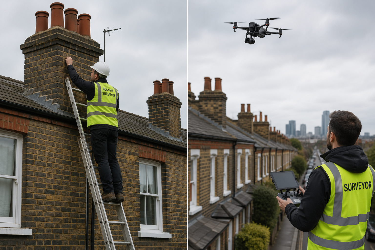
- Drone inspections dramatically improve access to hard-to-reach party structures — parapets, chimney stacks, and shared gutters — that are routinely missed in traditional ground-level surveys
- A drone-assisted schedule of condition must meet the same evidential standards as a conventional schedule; the format and legal weight are unchanged, but the quality of evidence is substantially higher
- RICS launched a consultation on the 8th edition of "Party Wall Legislation and Procedure" in April 2026, with updated guidance expected to embed technology-assisted inspection as standard practice [1]
- Surveyors must hold valid Civil Aviation Authority (CAA) drone operator credentials and carry adequate professional indemnity insurance before flying in residential party wall contexts
Why Drone Technology Is Reshaping Party Wall Surveying in 2026
The Party Wall etc. Act 1996 places a legal obligation on building owners to give notice before carrying out certain works, and on surveyors to document the existing condition of adjoining structures before those works begin. For decades, that documentation process was constrained by physical access. A surveyor standing at ground level, or even on a ladder, simply cannot reliably inspect the full face of a shared chimney stack, a parapet wall above a flat roof, or a rear elevation obscured by a conservatory extension.
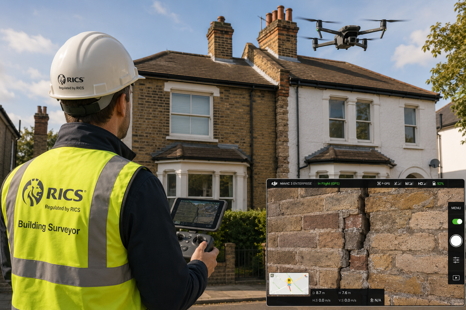
Drones resolve this access problem directly. Equipped with high-resolution cameras, thermal imaging sensors, and in some cases LiDAR (Light Detection and Ranging) capability, modern survey drones can capture detailed imagery of every surface of a party structure in a single site visit [5]. The result is a richer, more defensible schedule of condition — one that is far harder to challenge in the event of a dispute.
The practical advantages are significant:
- Inspection of areas above 4 metres that would otherwise require scaffold or access equipment
- Thermal imaging to detect moisture ingress, cold bridges, or hidden defects in party walls
- High-resolution photography that can be geo-tagged and time-stamped for legal purposes
- Reduced time on site, lowering costs for both building owner and adjoining owner
- Safer working conditions, eliminating the need for surveyors to work at height
For surveyors handling party wall matters across dense urban areas — where terraced houses, shared chimney breasts, and tight access lanes are the norm — drone capability is no longer a premium add-on. It is rapidly becoming a baseline expectation.
"The ability to document a party structure comprehensively, before a single brick is touched, is the single most powerful tool a surveyor has in preventing disputes from escalating."
RICS's own research confirms this trajectory. A 2023 article from RICS Firms noted that drones have enhanced the efficiency and accuracy of building evaluations, offering high-resolution imagery and data collection capabilities that traditional methods cannot match [5]. That momentum has only accelerated since.
RICS 2026 Standards: What the New Framework Requires
The April 2026 Party Wall Consultation
In April 2026, RICS launched a consultation for the 8th edition of "Party Wall Legislation and Procedure," with the consultation period closing on 5 June 2026 [1]. The draft guidance signals a clear direction: technology-assisted inspection, including drone surveys, is expected to be addressed explicitly within updated professional practice notes. Surveyors should monitor the publication of the final 8th edition closely, as it is likely to set minimum documentation standards that reflect current drone capabilities.
The AI and Technology Standard (Effective March 2026)
Separately, RICS published its global professional standard on the responsible use of artificial intelligence in surveying, which came into effect on 9 March 2026 [2]. This standard has direct relevance to drone work because modern drone platforms increasingly incorporate AI-driven features: automated defect detection, machine-learning-based image analysis, and AI-assisted report generation.
Under this standard, RICS members using AI-enhanced drone tools must:
- Be able to explain and justify any AI-generated outputs included in a party wall report
- Retain human oversight over all findings — AI analysis cannot substitute for professional judgement
- Disclose the use of AI tools to clients and, where relevant, to the adjoining owner's surveyor
- Ensure data handling complies with applicable privacy and data protection obligations
Surveyors contributing to RICS's Modus journal in January 2026 highlighted that AI adoption brings both efficiency gains and new professional responsibilities [3]. The consensus is clear: technology amplifies the surveyor's capability but does not transfer their liability.
Home Survey Standard Review
RICS is also reviewing the Home Survey Standard (originally published in 2019), with members advised to continue using the 1st edition until a 2nd edition is confirmed [4]. While this standard applies primarily to residential surveys rather than party wall work specifically, the underlying principles — thorough documentation, clear condition ratings, and transparent methodology — carry across. Surveyors using drones in RICS building surveys should ensure their drone inspection methodology aligns with whatever updated home survey guidance emerges.
Practical Protocols: How to Conduct a Drone-Assisted Party Wall Inspection
Pre-Flight Requirements and Legal Compliance
Before any drone is launched in connection with a party wall matter, the surveyor must satisfy several non-negotiable requirements:
| Requirement | Detail |
|---|---|
| CAA Operator Registration | Required for all drones over 250g in the UK |
| Flyer ID | The individual pilot must hold a valid CAA Flyer ID |
| Operational Authorisation | Required for flights near people or congested areas |
| Professional Indemnity Insurance | Must explicitly cover drone-assisted survey activities |
| Neighbour Notification | Both the building owner and adjoining owner should be informed |
| Privacy Compliance | Imagery must be limited to the subject structure; incidental capture of third-party property must be managed |
Flying a drone over or close to a residential property without appropriate authorisation creates both regulatory and civil liability. In party wall contexts, where relationships between neighbours are already potentially strained, a poorly managed drone flight can actively damage the surveyor's impartiality — a core professional obligation highlighted repeatedly in RICS ethics guidance [9][10].
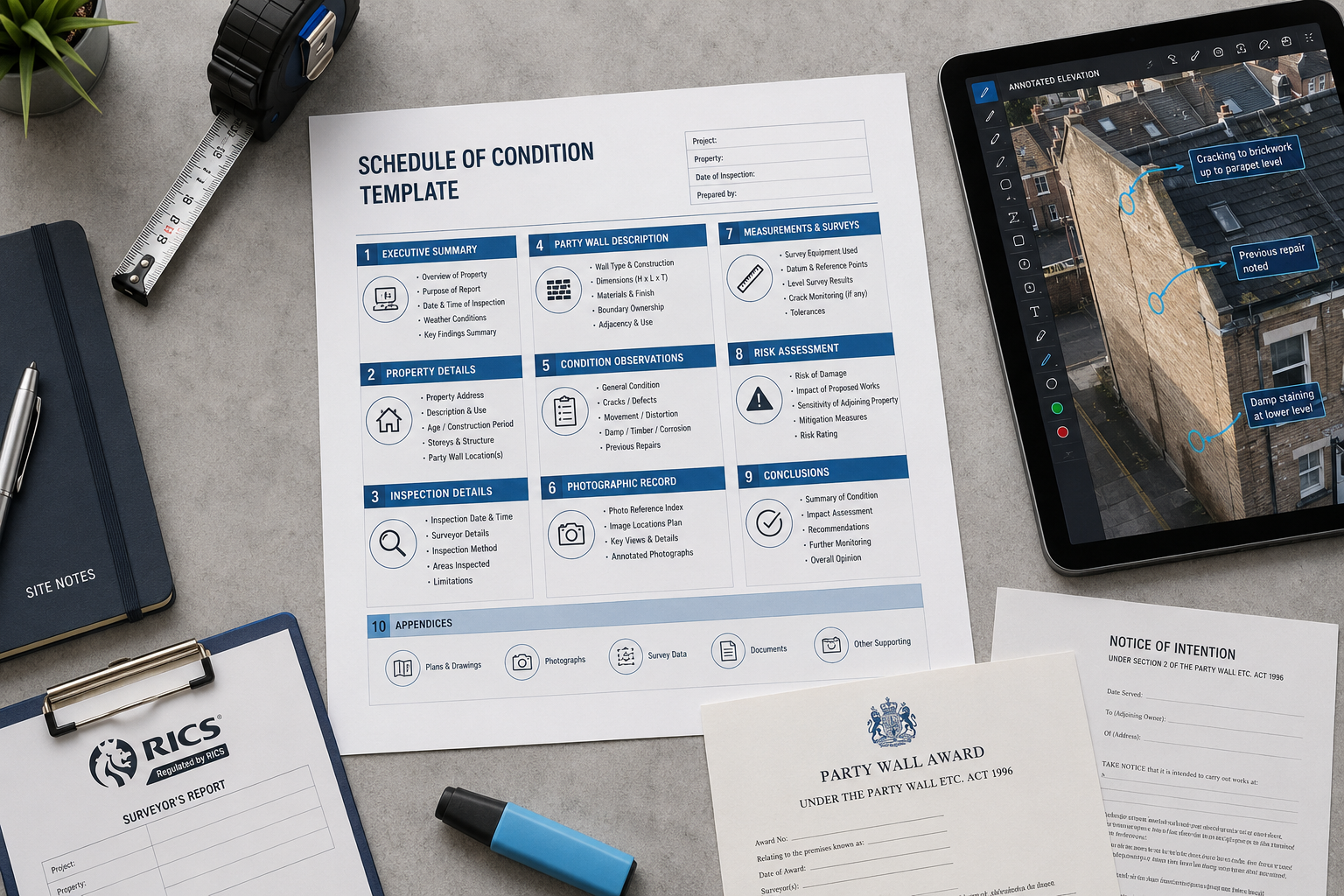
Building the Drone-Assisted Schedule of Condition
The schedule of condition is the cornerstone document in party wall practice. It records the pre-works condition of the adjoining owner's property so that any damage caused by the building owner's works can be identified and attributed accurately.
A drone-assisted schedule of condition should follow this structure:
1. Property Identification
Full address, description of the party structure(s) inspected, date of inspection, and drone equipment used (make, model, camera specification).
2. Methodology Statement
A brief explanation of how the drone was deployed, what areas were covered, and any limitations (e.g., areas not accessible due to wind conditions or airspace restrictions).
3. Photographic Record
High-resolution images organised by elevation and structural element. Each image should carry a geo-tag, timestamp, and brief written description of the condition shown.
4. Condition Notes
Written observations for each element — party wall face, chimney stack, parapet, shared gutter, flashing, and so on — cross-referenced to the photographic record.
5. Thermal Imaging Summary (where used)
If a thermal camera was deployed, a separate section should summarise any anomalies detected, with appropriate caveats about interpretation.
6. Surveyor's Declaration
Confirmation that the schedule represents the surveyor's professional opinion of the pre-works condition, prepared impartially and in accordance with RICS standards.
This level of documentation is particularly important when consent for party wall work has been given and works are about to commence, as it establishes the baseline against which any post-works damage claim will be measured.
Handling Excavation Near Neighbouring Structures
Drone surveys are especially valuable in matters involving notice for excavation near a neighbour, where subsidence risk and foundation exposure make comprehensive pre-works documentation critical. A drone can capture the full rear elevation of an adjoining property, including areas above a single-storey extension or outbuilding, that a ground-level survey would miss entirely.
When excavation works are planned within three metres of an adjoining structure, the surveyor should consider whether a drone inspection of the full affected elevation is warranted — and in most urban cases, the answer will be yes.
Liability, Impartiality, and Ethical Considerations
The Surveyor's Duty of Impartiality
Party wall surveyors occupy a unique professional position. Unlike most surveying roles, a party wall surveyor appointed under the Act owes a duty not only to the party who appointed them, but to the process itself — and by extension to both parties. RICS ethics guidance is explicit on this point: surveyors must avoid bias and potential conflicts of interest at all stages of party wall work [10].
Drone technology introduces a subtle but real risk to impartiality if it is not managed carefully. If the building owner's surveyor conducts the drone inspection unilaterally, without the adjoining owner's surveyor being present or given the opportunity to review the methodology, the resulting schedule may be challenged. Best practice in 2026 is to:
- Notify the adjoining owner's surveyor in advance of the drone inspection date
- Provide a copy of the raw imagery alongside the finished schedule
- Use a mutually agreed drone operator where the parties have agreed to a single agreed surveyor
Professional Indemnity and Data Retention
Drone-generated data — particularly high-resolution imagery and thermal scans — must be stored securely and retained for a period consistent with the surveyor's professional indemnity insurance requirements. In party wall matters, where disputes can arise years after works are completed, a minimum retention period of six years is advisable.
Surveyors should also be aware that imagery captured during a drone inspection may be disclosable in legal proceedings. Every image taken on site is potentially evidence, which reinforces the importance of systematic, well-organised data management from the outset.
When Drone Inspection Is Not Appropriate
Drones are a tool, not a universal solution. There are circumstances where a drone inspection is impractical or inadvisable:
- High-density urban environments where CAA operational authorisation for congested areas is difficult to obtain
- Adverse weather conditions — wind speeds above 20 mph, rain, or low visibility compromise both safety and image quality
- Properties with sensitive occupants — care homes, schools, or properties where overflying would cause distress
- Where access to the adjoining owner's airspace is disputed — a drone flying over a neighbouring property requires either consent or appropriate authorisation
In these cases, surveyors should revert to traditional access methods, or commission scaffold or cherry-picker access where the inspection of specific elements is essential to the party wall award.
Integrating Drone Data with Wider Survey Practice
The value of drone inspection extends beyond party wall work alone. Surveyors who develop drone competency find that the same capability enhances RICS specialist defect surveys, roof surveys, and RICS Level 3 building surveys — particularly for older or larger properties where elevated structures are a primary concern.
The cross-disciplinary benefit is real. A surveyor who uses drone technology in a party wall schedule of condition on a Victorian terrace may simultaneously identify defects in the main roof, chimney flashings, or rear parapet that are relevant to a concurrent building survey instruction. Integrated reporting — where drone data is used across multiple survey types in a single site visit — represents a significant efficiency gain for both the surveyor and the client.
RICS's structured CPD pathway for party wall work, including the "Party Walls: The Fundamentals" course offering 15 hours of structured learning [8], does not yet formally incorporate drone competency modules. However, surveyors are expected to maintain competency in the tools they use, and drone operation — including data management and report integration — should be documented as part of any surveyor's CPD record.
A Note on Costs and Client Expectations
Drone-assisted inspections do carry a cost premium over purely ground-level surveys. However, the cost of a thorough drone-assisted schedule of condition is almost always lower than the cost of a disputed party wall matter that proceeds to the third surveyor mechanism — or worse, to litigation.
Clients and adjoining owners who understand this equation are generally receptive to drone-assisted approaches. Surveyors should explain the methodology clearly, including what a drone inspection can and cannot detect, and ensure that fee proposals reflect the additional equipment, insurance, and data management costs involved. For guidance on how surveying fees are structured, the guide to understanding surveyor rates provides a useful reference point.
Conclusion
The Building Surveyor Guide to Drone Inspections in Party Wall Matters: 2026 RICS Tech Standards reflects a profession in active transition. Drone technology has moved from novelty to necessity in the space of a few years, driven by genuine improvements in inspection quality, access capability, and dispute prevention. The 2026 RICS standards framework — spanning the April party wall consultation, the March AI standard, and the ongoing Home Survey Standard review — provides the professional architecture within which drone-assisted practice must operate.
Actionable next steps for building surveyors in 2026:
- Obtain CAA credentials — Ensure both operator registration and flyer ID are current before conducting any drone-assisted party wall inspection
- Review professional indemnity cover — Confirm that drone activities are explicitly included in your policy
- Update schedule of condition templates — Incorporate a methodology statement, geo-tagged imagery section, and thermal imaging summary where applicable
- Monitor the RICS 8th edition publication — The updated "Party Wall Legislation and Procedure" guidance will set the definitive standard for technology-assisted inspection
- Document drone CPD — Record training, equipment familiarisation, and any AI tool usage as part of your annual CPD log
- Communicate proactively with adjoining owners' surveyors — Transparency about drone methodology protects impartiality and reduces the risk of challenge
Surveyors who build drone competency into their practice now will be better positioned to meet the documentation standards that RICS is clearly moving toward — and better equipped to serve clients on both sides of the party wall.
References
[1] RICS Launches Consultation on Updated Party Wall Practice Guidance – https://www.rics.org/news-insights/rics-launches-consultation-on-updated-party-wall-practice-guidance?utm_source=openai
[2] RICS Launches Landmark Global Standard on Responsible Use of AI in Surveying – https://www.rics.org/news-insights/rics-launches-landmark-global-standard-on-responsible-use-of-ai-in-surveying?utm_source=openai
[3] What Surveyors Think About AI – https://ww3.rics.org/uk/en/modus/technology-and-data/surveying-tools/what-surveyors-think-ai.html?utm_source=openai
[4] Home Survey Standards – https://www.rics.org/profession-standards/rics-standards-and-guidance/sector-standards/building-surveying-standards/home-surveys/home-survey-standards?utm_source=openai
[5] How Have Drones Impacted Building Surveying – https://www.ricsfirms.com/residential/moving-home/surveys/how-have-drones-impacted-building-surveying/?utm_source=openai
[8] Party Walls: The Fundamentals – https://www.rics.org/training-events/online-training/on-demand/party-walls-the-fundamentals?utm_source=openai
[9] Ethics and Party Wall Practice – https://ww3.rics.org/uk/en/journals/property-journal/ethics-and-party-wall-practice.html?utm_source=openai
[10] Fair Principles for Party Walls – https://ww3.rics.org/uk/en/journals/property-journal/fair-principles-for-party-walls.html?utm_source=openai