The surveying profession stands at a transformative crossroads in 2026. 3D laser scanning technology has evolved from an expensive specialty tool into an accessible, indispensable asset that is reshaping how professionals capture, analyze, and deliver spatial data. As the 3D Laser Scanning Services market surges from $8.84 billion in 2025 to a projected $9.62 billion in 2026—representing robust 8.8% growth[5]—surveying firms of all sizes are discovering that adoption is no longer optional but essential for competitive survival. This comprehensive guide explores 3D Laser Scanning Adoption in Surveying: Trends and Best Practices for 2026, providing actionable insights into technology integration, accuracy benchmarks, and cost-effective implementation strategies that are making precision mapping accessible to smaller firms while revolutionizing workflows for established practices.
Key Takeaways
- Hybrid scanning workflows combining terrestrial laser scanning (TLS), mobile SLAM, and drone-mounted systems now deliver survey-grade accuracy (sub-millimeter) with unprecedented speed and coverage[3]
- Market accessibility has dramatically improved as processing algorithms advance and equipment costs decline, enabling smaller firms to compete effectively in infrastructure and construction projects[2]
- Industry applications in construction, mining, heritage preservation, and forensic documentation are driving adoption, with firms achieving measurable reductions in revision cycles, downtime, and coordination friction[2]
- Real-time quality feedback integrated into modern devices prevents costly data gaps and drift issues, transforming field capture strategies and reducing resurvey requirements[3]
- ROI thresholds continue to fall as the specialized 3D Laser Scanning for Metrology Market projects growth of USD 1,545.92 million at a CAGR of 7.51% through 2032[1]
Understanding 3D Laser Scanning Technology in Modern Surveying
3D laser scanning represents a quantum leap beyond traditional surveying methods. Rather than capturing individual points through time-consuming total station measurements, laser scanners emit millions of laser pulses per second, creating dense point clouds that represent physical environments with extraordinary detail. Each point contains precise X, Y, and Z coordinates, plus often intensity and color information, building a comprehensive digital twin of the surveyed space.
The Technology Behind the Revolution
Modern laser scanning systems operate on time-of-flight or phase-shift principles. Time-of-flight scanners measure the time a laser pulse takes to travel to an object and return, calculating distance with remarkable precision. Phase-shift scanners compare the phase of emitted and reflected laser waves, enabling faster capture rates ideal for shorter-range applications.
The breakthrough in 2026 lies not just in individual scanner capabilities but in multi-layer LiDAR sensors that capture millions of points per second with significantly reduced noise[3]. This advancement enables cleaner definition of sharp architectural features like door frames, pipes, and structural details that previously required manual cleanup or supplementary measurements.
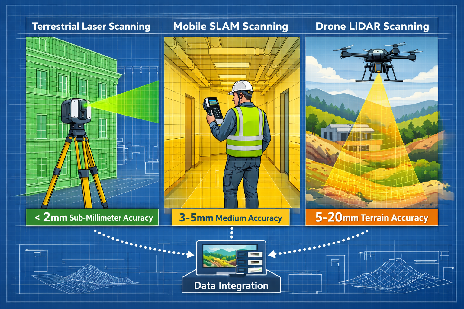
Three Primary Scanning Modalities
Understanding the distinct roles of each scanning approach is fundamental to implementing effective workflows:
| Scanning Type | Accuracy Range | Typical Speed | Best Applications |
|---|---|---|---|
| Terrestrial Laser Scanning (TLS) | < 2 mm | Moderate (5-10 min per setup) | Geometric control, high-precision surveys, structural monitoring |
| Mobile SLAM | 3-5 mm (hybrid) / 5-20 mm (standalone) | Fast (walking speed) | Interior spaces, corridors, rapid area coverage |
| Drone-Mounted LiDAR | 5-20 mm | Very Fast (flight speed) | Terrain mapping, infrastructure corridors, inaccessible areas |
The "Precision Backbone" approach has become the default specification for large-scale reality capture projects in 2026[3]. Static terrestrial laser scanners establish geometric control with sub-millimeter accuracy and georeferenced tie-in points, while mobile SLAM rapidly fills data gaps. This hybrid methodology achieves 3-5 mm local accuracy—a dramatic improvement over mobile SLAM alone while maintaining survey-grade global precision[3].
Automatic Registration and Drift Elimination
Perhaps the most significant workflow advancement involves automatic registration software that now detects rigid TLS scans and constrains mobile SLAM trajectories to them[3]. This effectively eliminates the drift accumulation that plagued earlier mobile scanning efforts, producing point clouds that combine survey-grade global accuracy with rapid, complete coverage.
For firms considering adoption, this means the technical barriers that once required specialized expertise have largely dissolved. Modern systems guide operators through capture, automatically flag potential quality issues, and produce deliverable-ready data with minimal post-processing intervention.
Hybrid Workflows: The New Standard for 3D Laser Scanning Adoption in Surveying
The industry standard in 2026 has shifted decisively away from the static-versus-mobile debate toward integrated hybrid workflows that leverage the strengths of multiple capture technologies[3]. This evolution represents more than technical sophistication—it fundamentally changes how surveying projects are scoped, priced, and delivered.
Implementing the Precision Backbone Strategy
The Precision Backbone methodology follows a systematic approach:
Step 1: Establish Control Network
Deploy terrestrial laser scanners at strategic locations to create a high-accuracy geometric framework. These stations serve as absolute reference points with sub-millimeter precision, typically positioned at:
- Building corners and structural intersections
- Elevation changes and level transitions
- Areas requiring maximum measurement certainty
- Locations with clear sightlines to adjacent stations
Step 2: Rapid Infill with Mobile SLAM
Use handheld or backpack-mounted SLAM scanners to quickly capture areas between control points. The mobile system automatically recognizes TLS reference scans and constrains its trajectory calculations, preventing drift accumulation.
Step 3: Specialized Coverage
Deploy drone-mounted LiDAR for exterior corridors, terrain, or inaccessible areas. Georeferenced tie-points ensure seamless integration with terrestrial data.
Step 4: Automated Processing
Modern registration software automatically aligns all data sources, producing unified point clouds that maintain survey-grade accuracy throughout.
Real-Time Quality Feedback
Devices now feature integrated real-time quality feedback, including confidence maps that alert operators to feature-poor environments such as long, smooth tunnels where drift is likely[3]. This capability enables responsive capture strategy adjustments in the field, dramatically reducing the costly need for resurveys.
Operators receive immediate visual feedback showing:
- 📊 Point density coverage across captured areas
- ⚠️ Drift risk indicators in featureless zones
- ✅ Registration confidence between scan positions
- 🎯 Accuracy estimates for different regions
Integration with Traditional Survey Methods
Hybrid workflows don't replace traditional surveying—they enhance it. Structural surveys and RICS building surveys increasingly incorporate laser scanning data to supplement visual inspections with precise dimensional verification. This combination provides clients with both professional assessment and quantitative spatial documentation.
For firms offering commercial building surveys, the integration of 3D scanning data elevates deliverables from subjective observations to measurable, defensible documentation that supports renovation planning, compliance verification, and asset management.
Industry Applications Driving 3D Laser Scanning Adoption in Surveying
The explosive growth in laser scanning adoption stems from compelling use cases across diverse sectors. Understanding these applications helps firms identify opportunities and develop specialized service offerings.
Construction and Civil Engineering
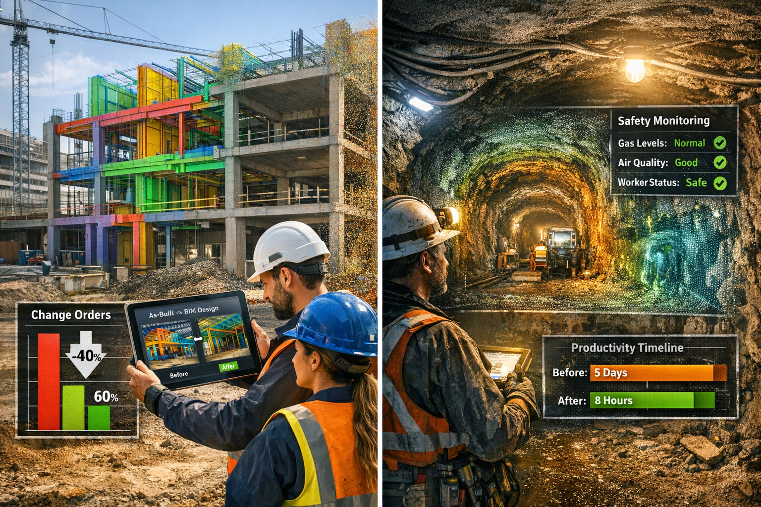
Construction and civil engineering firms now deploy tiered capture strategies as standard practice[2]. Professionals use 3D scanners to produce as-built models, enhance design coordination, and reduce revision cycles, change orders, and stakeholder coordination friction on large-scale projects.
Key Benefits:
- Clash Detection: Identify conflicts between design intent and existing conditions before construction begins
- Progress Monitoring: Document construction phases with millimeter precision for schedule verification
- Quality Assurance: Verify installed work against specifications with quantitative tolerance analysis
- Change Order Defense: Provide irrefutable documentation of site conditions and scope changes
The impact on project economics is substantial. Firms report 30-50% reductions in RFIs (Requests for Information) and change orders when laser scanning informs preconstruction planning. This directly translates to improved margins and client satisfaction.
Mining Operations
Deep mining operations are rapidly displacing conventional surveying with laser scanning[2]. Operators now produce comprehensive mine-wide models in hours rather than days, enabling real-time ground-control decision making and achieving measurable gains in productivity, reduced downtime, and enhanced worker safety.
Underground environments present unique challenges—limited GPS access, hazardous conditions, and constantly changing geometry. Mobile SLAM systems excel in these conditions, allowing operators to safely capture tunnel networks, stope volumes, and infrastructure layouts while minimizing personnel exposure to dangerous areas.
"The transition from traditional tape-and-theodolite surveys to laser scanning has transformed our safety culture. We can now assess ground conditions and calculate ore volumes without prolonged personnel exposure in active mining zones." — Mining Operations Manager
Heritage Preservation and Documentation
Heritage preservation and documentation leverages noninvasive terrestrial scanning for cultural conservation[1]. Historic structures often cannot accommodate invasive measurement techniques, making laser scanning the ideal solution for:
- Creating permanent digital archives of at-risk structures
- Developing restoration plans with precise dimensional data
- Monitoring structural movement and deterioration over time
- Producing virtual tours and educational materials
The democratization of scanning technology has made heritage documentation accessible to smaller preservation societies and local historical organizations, not just well-funded national institutions.
Public Safety and Forensic Applications
Public safety and forensic teams employ scan data to reconstruct incident scenes with legal-grade accuracy[1], improving investigative outcomes and courtroom presentations. Accident reconstruction, crime scene documentation, and fire investigation all benefit from the ability to capture complete spatial context within hours of an incident.
Laser scans provide:
- Permanent Records: Scene conditions preserved exactly as found
- Measurement Certainty: Distances, angles, and positions verified to millimeter precision
- Virtual Scene Reconstruction: Investigators can revisit and analyze scenes long after physical evidence is cleared
- Compelling Courtroom Exhibits: Juries can virtually "walk through" incident scenes
For surveying firms, forensic services represent a high-value niche requiring specialized expertise but offering premium pricing and steady demand.
Accuracy Benchmarks and Quality Standards
Understanding and communicating accuracy expectations is critical for successful project delivery and client satisfaction. The 3D Laser Scanning Adoption in Surveying: Trends and Best Practices for 2026 requires clear specification of precision requirements matched to appropriate capture methodologies.
Defining Accuracy in Point Cloud Surveys
Accuracy specifications must address multiple dimensions:
Absolute Accuracy: How closely scan coordinates match real-world positions in a defined coordinate system (e.g., state plane, UTM, local grid)
Relative Accuracy: How precisely features are positioned relative to each other within the scan data
Point Precision: The repeatability of individual point measurements
Registration Error: Positional discrepancies introduced when aligning multiple scan positions
Industry Standard Accuracy Ranges
Modern equipment achieves the following typical accuracies under optimal conditions:
🎯 Terrestrial Laser Scanning (TLS)
- Single point precision: ±1-2 mm at 10m range
- Absolute accuracy: ±2-3 mm with proper control
- Angular accuracy: 8-20 arc seconds
- Best for: Structural monitoring, deformation analysis, precision as-builts
🎯 Mobile SLAM (Hybrid Workflow)
- Local accuracy: 3-5 mm when constrained to TLS control[3]
- Standalone accuracy: 5-20 mm depending on trajectory length
- Best for: Building interiors, rapid area surveys, corridor mapping
🎯 Drone-Mounted LiDAR
- Vertical accuracy: 5-15 cm with RTK/PPK GPS
- Horizontal accuracy: 5-20 cm
- Best for: Topographic surveys, stockpile volumes, corridor mapping
Quality Control Procedures
Implementing systematic quality control ensures deliverables meet specifications:
Pre-Survey Planning
- Define accuracy requirements based on project deliverables
- Select appropriate equipment and methodology
- Establish control network with survey-grade GNSS or total station
- Plan scan positions for adequate overlap (30-50% recommended)
Field Verification
- Deploy survey targets or spheres for registration verification
- Capture check measurements with independent methods
- Monitor real-time quality indicators during capture
- Document environmental conditions affecting accuracy
Post-Processing Validation
- Verify registration errors remain within specification
- Compare scan measurements to independent check points
- Assess point cloud noise and outlier distribution
- Generate accuracy reports for client documentation
For firms offering homebuyer surveys or choosing the right property survey services, incorporating laser scanning data provides dimensional verification that enhances traditional visual inspections, particularly for complex properties or those with suspected structural issues.
Cost-Benefit Analysis: Making the Business Case for Adoption
The cost-benefit threshold for 3D laser scanning adoption continues to fall due to processing algorithm improvements and proliferation of mobile/hybrid scanners[2], opening opportunities in renovation, heritage preservation, and disaster-response documentation.
Equipment Investment Ranges
Understanding equipment costs helps firms plan adoption strategies:
Entry-Level Solutions ($15,000 – $40,000)
- Handheld SLAM scanners
- Limited range (20-30m typical)
- Suitable for interior surveys, small sites
- Lower accuracy (10-20mm typical)
- Ideal for: Small firms, specialized applications, supplementing traditional methods
Mid-Range Professional Systems ($40,000 – $100,000)
- Terrestrial laser scanners with moderate range (100-150m)
- Mobile SLAM systems with enhanced accuracy
- Integration capabilities with total stations and GNSS
- Ideal for: General surveying firms, construction documentation, facility management
High-End Survey-Grade Equipment ($100,000 – $200,000+)
- Long-range TLS (300m+) with sub-millimeter precision
- Integrated imaging and positioning systems
- Advanced environmental compensation
- Ideal for: Large infrastructure projects, mining, precision industrial applications
Hidden Costs and Considerations
Beyond equipment purchase, firms must budget for:
- Software Licensing: Processing and modeling software ($3,000-$15,000 annually)
- Training: Operator certification and ongoing education ($2,000-$5,000 per person)
- Computing Infrastructure: High-performance workstations for point cloud processing ($3,000-$8,000)
- Data Storage: Expanding storage for large scan datasets ($1,000-$5,000 annually)
- Maintenance: Equipment calibration and service contracts (5-10% of equipment cost annually)
Return on Investment Metrics
Successful adopters report ROI through multiple channels:
Revenue Enhancement
- Premium pricing for scan-enhanced deliverables (20-40% higher fees)
- New service offerings (as-built modeling, clash detection, progress monitoring)
- Expanded client base (contractors, architects, facility managers)
Efficiency Gains
- Reduced site visit time (single comprehensive capture vs. multiple traditional surveys)
- Decreased resurvey requirements due to complete data capture
- Automated deliverable generation from point cloud data
Risk Reduction
- Fewer measurement errors and omissions
- Defensible documentation for dispute resolution
- Enhanced professional liability profile
Accessibility for Smaller Firms
The democratization of laser scanning technology particularly benefits smaller practices. Handheld laser scanners have made rapid indoor and small-area scans feasible through portability and user-friendly interfaces[1], eliminating the technical barriers that once limited adoption to large firms with dedicated specialists.
Smaller firms can enter the market through:
Rental and Project-Based Acquisition
- Rent equipment for specific projects to build experience
- Assess client demand before capital commitment
- Access latest technology without depreciation concerns
Specialized Service Niches
- Focus on applications where traditional methods are inadequate (heritage documentation, complex renovations)
- Develop expertise in specific sectors (residential, small commercial, forensic)
- Partner with larger firms as scanning subcontractors
Incremental Adoption
- Start with handheld SLAM for interior surveys
- Add terrestrial scanning as project complexity grows
- Expand to hybrid workflows as expertise develops
For practices offering different types of survey comparison services, laser scanning provides a competitive differentiator that justifies premium positioning while delivering superior client value.
Best Practices for Successful Implementation
Successful 3D Laser Scanning Adoption in Surveying: Trends and Best Practices for 2026 requires more than equipment acquisition—it demands systematic implementation of proven workflows, training protocols, and quality management systems.
Developing Capture Strategies
Project Planning Framework
Every scanning project should begin with systematic planning:
-
Define Deliverable Requirements
- What products will be delivered? (point cloud, CAD drawings, BIM model, mesh)
- What accuracy is required for the intended use?
- What level of detail must be captured?
-
Select Appropriate Methodology
- Match equipment capabilities to accuracy requirements
- Consider site access, safety, and environmental constraints
- Plan hybrid approaches for complex projects
-
Design Scan Network
- Calculate required scan positions for complete coverage
- Ensure adequate overlap between adjacent scans (30-50%)
- Position control targets for registration verification
-
Prepare Site Documentation
- Obtain site access permissions and safety clearances
- Coordinate with active operations (construction, facility management)
- Document pre-existing conditions and constraints
Operator Training and Certification
Equipment manufacturers and industry organizations now offer structured training programs:
Essential Competencies
- Equipment operation and safety protocols
- Understanding accuracy specifications and limitations
- Registration and processing workflows
- Quality control procedures
- Deliverable generation and client communication
Continuing Education
- Software updates and new feature training
- Industry-specific application workshops
- Professional development through organizations like RICS, NSPS, ASCE
Data Management and Processing Workflows
Point cloud datasets are massive—individual projects can generate hundreds of gigabytes. Effective data management requires:
Standardized Naming Conventions
- Project identification codes
- Scan position or area designations
- Date and time stamps
- Processing version control
Storage Infrastructure
- Local high-speed storage for active projects
- Network-attached storage for collaborative access
- Cloud backup for long-term archival
- Data retention policies aligned with professional liability requirements
Processing Workflows
- Automated registration using targets and cloud-to-cloud alignment
- Noise filtering and outlier removal
- Decimation for deliverable optimization
- Export to client-specified formats
Integration with Existing Services
The most successful adopters integrate scanning with established service offerings rather than treating it as a separate product line. For example:
- RICS Home Survey reports enhanced with dimensional verification
- Structural engineering assessments supported by deformation monitoring
- Boundary surveys with comprehensive topographic context
- Commercial property surveys with complete as-built documentation
This integration approach maximizes utilization of scanning equipment while providing clients with comprehensive, high-value deliverables that justify premium pricing.
Overcoming Common Adoption Challenges

Despite the compelling benefits, firms encounter predictable challenges during adoption. Understanding these obstacles and proven mitigation strategies accelerates successful implementation.
Technical Challenges
Challenge: Registration Errors in Complex Environments
Large projects with numerous scan positions can accumulate registration errors, particularly in feature-poor environments like warehouses or tunnels.
Solution: Implement the Precision Backbone approach with strategic TLS control points constraining mobile SLAM trajectories[3]. Deploy survey targets throughout the project area and verify registration accuracy against independent check measurements.
Challenge: Data Processing Bottlenecks
Point cloud processing can overwhelm underpowered computers, creating project delivery delays.
Solution: Invest in workstations with high-core-count processors (16+ cores), 64GB+ RAM, and professional-grade GPUs. Consider cloud processing services for exceptionally large datasets. Implement overnight processing workflows to maximize productivity.
Challenge: Software Interoperability
Clients may require deliverables in specific formats not natively supported by scanning software.
Solution: Establish export workflows through industry-standard formats (E57, LAS, RCP) and modeling platforms (Revit, AutoCAD Civil 3D, Rhino). Develop templates for common deliverable types to streamline production.
Organizational Challenges
Challenge: Staff Resistance to Technology Change
Experienced surveyors may resist adopting new methods, preferring familiar traditional techniques.
Solution: Involve staff in equipment selection and pilot projects. Demonstrate efficiency gains and reduced physical demands. Provide comprehensive training and mentoring. Celebrate early successes and share client feedback highlighting scanning benefits.
Challenge: Client Education and Expectation Management
Clients may not understand scanning capabilities, limitations, or appropriate applications.
Solution: Develop clear service descriptions and sample deliverables. Create case studies demonstrating value in specific applications. Offer pilot projects at reduced rates to demonstrate capabilities. Provide transparent accuracy specifications and limitations.
Challenge: Project Pricing and Scope Definition
Determining appropriate pricing for scanning services can be difficult without established benchmarks.
Solution: Track time and costs for initial projects to establish baseline metrics. Research competitor pricing in your market. Price based on value delivered rather than time invested. Consider tiered pricing based on accuracy requirements, deliverable complexity, and turnaround time.
Future Trends: What's Next for Laser Scanning in Surveying
The broader 3D Laser Scanning Services Market is anticipated to surpass $7.38 billion by 2032 with a CAGR of over 14.9% from 2025 to 2032[8], signaling sustained growth and continued innovation. Understanding emerging trends helps firms position for future opportunities.
Artificial Intelligence and Automated Feature Extraction
Machine learning algorithms are increasingly capable of automatically identifying and classifying features within point clouds:
- Automated BIM Generation: AI extracts walls, doors, windows, and structural elements, creating Revit models with minimal manual intervention
- Defect Detection: Algorithms identify cracks, spalling, corrosion, and other defects in infrastructure inspections
- Change Detection: Automated comparison of time-series scans highlights modifications, deformation, or construction progress
These capabilities will dramatically reduce post-processing time, making scanning economically viable for smaller projects currently served by traditional methods.
Integration with Digital Twin Ecosystems
Laser scanning is becoming the foundation for digital twin implementations—persistent virtual replicas of physical assets updated throughout their lifecycle. Surveying firms can position as digital twin creators and maintainers, providing:
- Initial baseline documentation
- Periodic update scans tracking changes and deterioration
- Integration with IoT sensors and building management systems
- Simulation and analysis platforms for facility optimization
Miniaturization and Sensor Fusion
Scanning sensors continue shrinking while performance improves. Emerging trends include:
- Smartphone-Integrated LiDAR: Consumer devices with scanning capability enabling quick preliminary surveys
- Wearable Scanners: Lightweight systems for hands-free capture
- Multi-Sensor Fusion: Combining LiDAR with photogrammetry, thermal imaging, and ground-penetrating radar for comprehensive site characterization
Autonomous and Robotic Scanning
Autonomous systems are emerging for routine scanning applications:
- Robotic Platforms: Wheeled or tracked robots navigate sites independently, capturing scans without human operators
- Drone Swarms: Coordinated multi-drone systems for rapid large-area coverage
- Permanent Installation: Fixed scanners for continuous monitoring of critical infrastructure
Conclusion: Embracing the Future of Surveying
The evidence is compelling: 3D Laser Scanning Adoption in Surveying: Trends and Best Practices for 2026 represents not a futuristic possibility but a present-day imperative. The technology has matured beyond specialized applications to become a foundational capability for competitive surveying practices. With the market demonstrating robust 8.8% annual growth[5] and the specialized metrology segment projecting USD 1,545.92 million expansion at 7.51% CAGR through 2032[1], the trajectory is clear—laser scanning is transitioning from competitive advantage to baseline expectation.
The democratization of this technology through declining costs, improved usability, and hybrid workflows means smaller firms can now compete effectively with larger practices in infrastructure and construction projects. The Precision Backbone approach delivers survey-grade accuracy with unprecedented efficiency, while real-time quality feedback prevents costly errors and resurveys[3].
Actionable Next Steps
For firms ready to embrace laser scanning adoption:
-
Assess Your Market Position
- Identify client needs that scanning addresses (as-built documentation, clash detection, heritage preservation)
- Evaluate competitor capabilities and market gaps
- Define service offerings that integrate scanning with existing expertise
-
Start with Targeted Pilot Projects
- Select projects where scanning provides clear value over traditional methods
- Document time savings, accuracy improvements, and client satisfaction
- Build case studies demonstrating ROI and capabilities
-
Invest in Training and Infrastructure
- Prioritize operator training and certification
- Establish processing workflows and quality control procedures
- Develop data management systems for long-term sustainability
-
Develop Client Education Materials
- Create sample deliverables and capability demonstrations
- Establish transparent pricing and service descriptions
- Build relationships with architects, engineers, and contractors who value scanning data
-
Plan for Continuous Improvement
- Monitor emerging technologies and workflow innovations
- Participate in professional organizations and training opportunities
- Regularly assess equipment capabilities against evolving project requirements
The surveying profession has always evolved with technological advancement—from chains and compasses to total stations and GPS. 3D laser scanning represents the next chapter in this progression, offering unprecedented capabilities to those willing to embrace change. The firms that successfully implement these technologies today will define the industry standards of tomorrow, delivering superior value to clients while building sustainable competitive advantages in an increasingly demanding marketplace.
The question is no longer whether to adopt laser scanning, but how quickly and strategically your firm can integrate these capabilities to serve clients better, work more efficiently, and position for the opportunities ahead.
References
[1] 3d Laser Scanning For Metrology – https://www.360iresearch.com/library/intelligence/3d-laser-scanning-for-metrology
[2] 3d Laser Scanning Market Forecast – https://www.researchandmarkets.com/reports/6218922/3d-laser-scanning-market-forecast
[3] 3d Laser Scanning In 2026 Major Technology And Workflow Shifts – https://www.enginyring.com/en/blog/3d-laser-scanning-in-2026-major-technology-and-workflow-shifts
[5] 3d Laser Scanning Services Global Market Report – https://www.thebusinessresearchcompany.com/report/3d-laser-scanning-services-global-market-report
[8] 3d Laser Scanning Services Market – https://www.skyquestt.com/report/3d-laser-scanning-services-market