The land surveying profession stands at a transformative crossroads in 2026. Imagine processing millions of survey data points in minutes instead of hours, automatically detecting terrain anomalies without manual sorting, and predicting environmental disasters before they occur. This isn't science fiction—it's the reality of AI and Machine Learning in Land Surveying: Automating Data Analysis and Risk Prediction for 2026. As autonomous drones equipped with sophisticated sensors soar above construction sites and machine learning algorithms analyze massive datasets to identify patterns invisible to the human eye, the surveying industry is experiencing its most significant technological revolution since the introduction of GPS.
The integration of artificial intelligence into surveying workflows represents more than incremental improvement—it fundamentally reshapes how professionals collect, analyze, and interpret geospatial data. While adoption has been gradual, with only 27% of the architecture, engineering, and construction sector implementing AI as of December 2025, a remarkable 94% of early adopters plan to increase their AI usage throughout 2026[6]. This acceleration signals a tipping point where AI transitions from experimental technology to essential infrastructure.
Key Takeaways
- 🤖 Instant Processing Power: AI reduces survey data analysis time from hours to minutes, automatically classifying terrain, identifying markers, and flagging anomalies without manual intervention[2]
- 🚁 Autonomous Survey Operations: Multi-sensor drones with AI-driven flight planning now capture comprehensive site data in a single flight, replacing what previously required multiple visits[2]
- ⚠️ Predictive Risk Intelligence: Machine learning algorithms analyze historical and current data to forecast environmental hazards including flooding, landslides, and soil instability[3]
- 📊 Pattern Recognition at Scale: AI processes massive datasets to detect terrain changes over time, enabling continuous construction monitoring and change detection
- ☁️ Collaborative Cloud Integration: Fully integrated workflows centralize survey data management, enabling seamless team collaboration and real-time project updates[4]
Understanding AI and Machine Learning in Land Surveying for 2026
What Makes AI Different from Traditional Survey Technology
Traditional surveying relies heavily on manual data collection and human interpretation. A surveyor captures measurements using total stations, GPS receivers, or laser scanners, then spends considerable time processing this raw data into usable formats. The workflow involves sorting through thousands or millions of data points, identifying relevant features, removing errors, and creating deliverables like topographic maps or 3D models.
Artificial intelligence fundamentally changes this paradigm. Instead of requiring surveyors to manually classify every data point, AI algorithms automatically recognize patterns, categorize features, and extract meaningful information. Machine learning models trained on vast datasets can instantly distinguish between vegetation, buildings, roads, water bodies, and terrain features with remarkable accuracy[2].
The distinction becomes clearer when examining specific capabilities:
| Traditional Surveying | AI-Powered Surveying |
|---|---|
| Manual data classification | Automatic terrain categorization |
| Hours of processing time | Minutes to process equivalent data[2] |
| Reactive problem identification | Predictive risk forecasting[3] |
| Single-purpose data collection | Multi-sensor integrated analysis |
| Sequential workflow | Parallel automated processing |
| Limited pattern recognition | Comprehensive change detection across time |
Core Technologies Driving the 2026 Revolution
Several interconnected technologies enable AI and Machine Learning in Land Surveying: Automating Data Analysis and Risk Prediction for 2026:
Neural Networks and Deep Learning form the foundation of modern survey AI. These algorithms learn to recognize complex patterns by analyzing thousands of example datasets. A neural network trained on aerial imagery can automatically identify survey markers, detect vegetation encroachment, or classify land use types without explicit programming for each scenario.
Computer Vision enables AI systems to "see" and interpret visual data from drones, satellites, and ground-based cameras. Advanced computer vision algorithms can extract measurements directly from photographs, create 3D models from 2D images, and identify structural defects or terrain anomalies that might escape human observation.
LiDAR Integration provides the dense, precise point cloud data that AI algorithms thrive on. When drones equipped with LiDAR sensors fly over a site, they generate millions of elevation measurements. AI processes these massive point clouds to create detailed 3D landscape models, even penetrating dense vegetation to reveal ground topography[1].
Real-Time Kinematic (RTK) and Post-Processing Kinematic (PPK) positioning systems, when combined with AI, achieve positioning accuracy that surpasses traditional satellite-only methods. AI algorithms can identify and correct positioning errors, compensate for signal interference, and optimize measurement precision[3].
For surveyors considering which technologies to prioritize, understanding these foundational elements helps inform equipment investments and training priorities. Those conducting building surveys or drainage surveys can particularly benefit from AI-enhanced data processing capabilities.
How AI Automates Data Analysis in Modern Land Surveying
From Raw Data to Actionable Intelligence in Minutes
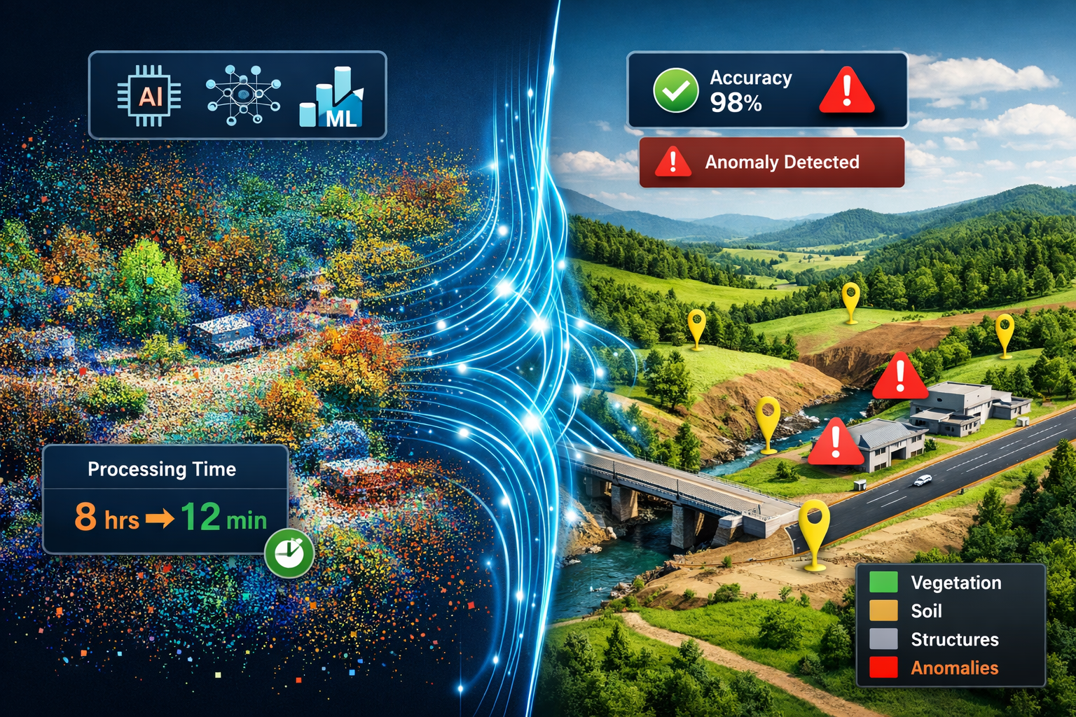
The most immediate impact of AI and Machine Learning in Land Surveying: Automating Data Analysis and Risk Prediction for 2026 appears in data processing workflows. Consider a typical large-scale topographic survey that generates 50 million LiDAR points. Traditional processing might require:
- 4-6 hours manually cleaning the point cloud
- 3-4 hours classifying ground points versus vegetation
- 2-3 hours identifying features and creating breaklines
- 2-3 hours generating contours and final deliverables
Total traditional processing time: 11-16 hours
With AI-powered automation, this same workflow transforms dramatically. The system automatically:
- Cleans the point cloud by identifying and removing outliers using statistical algorithms
- Classifies terrain features through trained neural networks that recognize ground, vegetation, buildings, and infrastructure
- Identifies survey markers and control points using computer vision
- Flags anomalies that require human review
- Generates preliminary 3D surface models ready for expert refinement
Total AI-assisted processing time: 12-20 minutes[2]
This efficiency gain doesn't simply save time—it fundamentally changes how surveyors allocate their expertise. Instead of spending hours on repetitive data sorting, professionals can focus on interpretation, quality control, and client consultation.
Automatic Terrain Classification and Feature Recognition
Modern AI systems excel at recognizing and categorizing landscape features with minimal human intervention. Machine learning algorithms trained on diverse datasets can automatically distinguish between:
- 🌳 Vegetation types (trees, shrubs, grass, crops)
- 🏢 Built structures (buildings, walls, fences, roads)
- 💧 Water features (rivers, ponds, drainage channels)
- 🪨 Terrain characteristics (bare earth, rock outcrops, soil types)
- 🚧 Infrastructure (utilities, poles, signs, pavement markings)
This classification happens at the point level, meaning each individual measurement receives appropriate categorization. For construction monitoring applications, AI can compare current site conditions against baseline surveys to automatically detect changes—identifying where excavation has occurred, materials have been stockpiled, or structures have been built[2].
The practical applications extend across surveying specialties. Professionals conducting stock condition surveys can leverage AI to identify structural changes over time, while those performing specific defect reports benefit from automated anomaly detection that highlights areas requiring detailed inspection.
Anomaly Detection and Quality Control
One of the most valuable AI capabilities involves identifying irregularities that might indicate errors or important features. Machine learning algorithms excel at pattern recognition, making them exceptionally effective at spotting outliers.
Quality Control Applications:
- Detecting measurement errors or GPS signal interference
- Identifying inconsistencies between overlapping survey datasets
- Flagging unusual terrain features that warrant investigation
- Recognizing equipment calibration issues through systematic error patterns
- Validating survey marker positions against control networks
Feature Detection Applications:
- Locating subsidence or settlement in monitored structures
- Identifying erosion patterns or slope instability
- Detecting unauthorized site modifications
- Recognizing utility conflicts or encroachments
- Spotting vegetation encroachment on infrastructure
The AI doesn't replace professional judgment—instead, it acts as an intelligent assistant that highlights areas requiring expert attention. A surveyor reviewing AI-processed data can quickly focus on the 2-3% of measurements that require detailed evaluation rather than manually inspecting 100% of the dataset.
This capability proves particularly valuable for subsidence surveys and monitoring surveys, where detecting subtle changes over time requires analyzing massive comparative datasets.
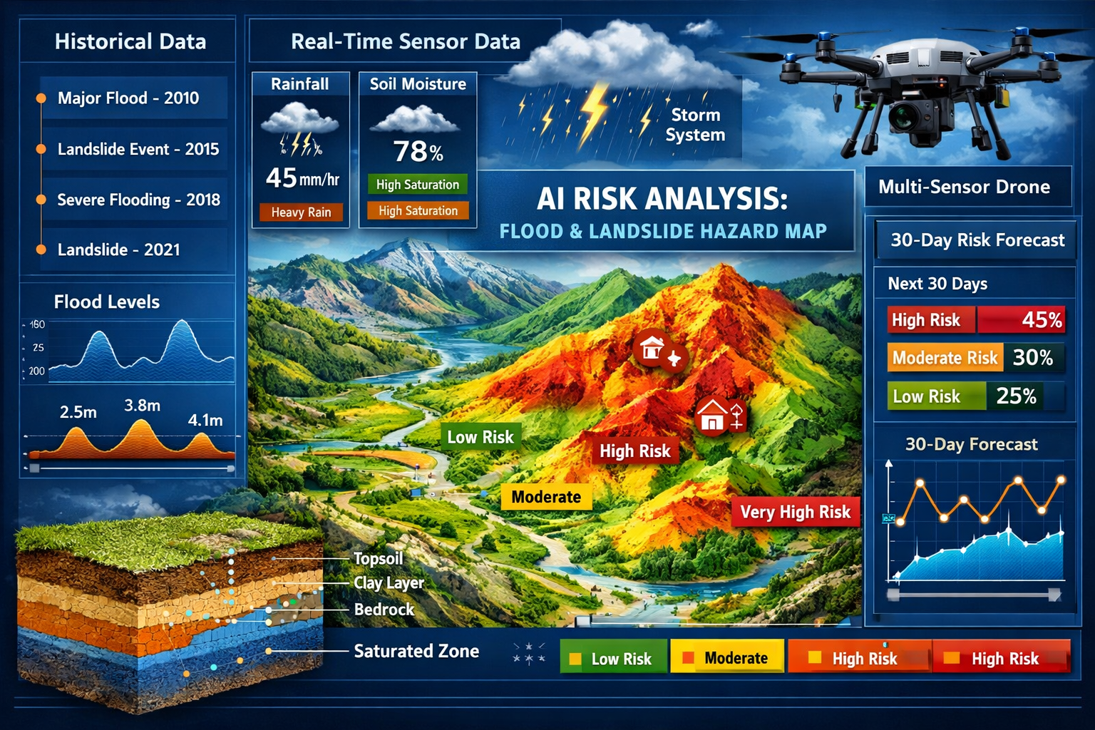
Predictive Risk Analysis: The Game-Changing Application
Environmental Hazard Forecasting Through Machine Learning
Perhaps the most transformative aspect of AI and Machine Learning in Land Surveying: Automating Data Analysis and Risk Prediction for 2026 lies in predictive capabilities. Traditional surveying documents current conditions—AI enables forecasting future risks.
Machine learning algorithms analyze multiple data sources simultaneously:
- Historical survey measurements showing terrain changes over years
- Current topographic conditions and slope characteristics
- Weather patterns and precipitation data
- Soil composition and permeability information
- Vegetation coverage and root structure analysis
- Groundwater levels and drainage patterns
- Seismic activity and geological fault mapping
By identifying correlations within these complex datasets, AI models can predict severe environmental hazards including flooding, landslides, and soil instability[3]. While these predictive tools remain in early development stages, their potential impact on public safety and project planning is substantial[3].
Flood Risk Prediction Models
Flood forecasting represents one of the most mature AI applications in surveying. Machine learning models process:
- Terrain elevation data to identify low-lying areas and natural drainage paths
- Historical flood events to recognize patterns and triggering conditions
- Rainfall predictions to model water accumulation scenarios
- Soil saturation levels to estimate infiltration capacity
- Drainage infrastructure capacity to identify bottlenecks
The AI generates probability-based flood risk maps showing which areas face elevated danger under various weather scenarios. Construction projects can use these predictions to:
- Optimize site grading and drainage design
- Identify appropriate building elevation requirements
- Plan temporary construction phase flood protection
- Schedule weather-sensitive activities during lower-risk periods
- Design long-term climate adaptation strategies
For professionals conducting drainage surveys, AI-enhanced flood modeling provides invaluable context for infrastructure recommendations.
Landslide and Slope Stability Assessment
Landslide prediction involves analyzing subtle terrain changes that might indicate impending slope failure. AI systems monitor:
- Micro-topographic changes detected through repeat surveys
- Slope angle variations that exceed stability thresholds
- Vegetation stress patterns visible in multispectral imagery
- Soil moisture fluctuations that reduce cohesion
- Historical movement patterns in known unstable areas
Machine learning algorithms trained on thousands of slope failure case studies can recognize the characteristic signatures that precede landslides. Early warning systems alert property owners, infrastructure managers, and emergency services when risk indicators exceed safe thresholds.
Soil Stability and Foundation Risk Analysis
For construction applications, soil stability prediction helps prevent foundation failures and structural damage. AI analyzes:
- Soil composition data from geotechnical investigations
- Groundwater level fluctuations over time
- Settlement measurements from nearby structures
- Load-bearing capacity variations across the site
- Seasonal expansion-contraction cycles in reactive soils
The predictive models identify areas where foundation design requires special consideration, potentially preventing costly structural issues. This capability directly supports professionals performing structural engineering assessments and RICS home surveys.
"AI systems now predict environmental hazards by analyzing patterns across massive historical and current datasets, enabling proactive risk management rather than reactive problem-solving."
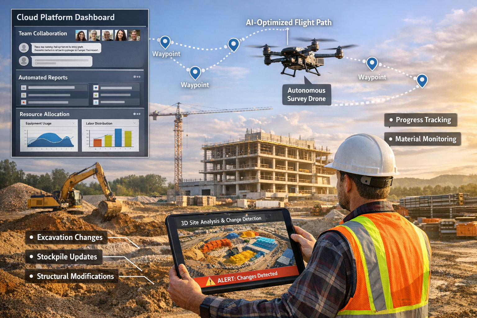
Autonomous Drone Technology and AI Integration
Multi-Sensor Platforms with Intelligent Flight Planning
The convergence of drone technology and artificial intelligence creates autonomous surveying capabilities that seemed impossible just years ago. Modern multi-sensor drones integrate:
- RGB cameras for high-resolution visual documentation
- LiDAR sensors for precise elevation mapping through vegetation[1]
- Multispectral cameras for vegetation health and moisture analysis
- Thermal imaging for heat signature detection
- RTK/PPK GPS for centimeter-level positioning accuracy[3]
What makes these platforms truly revolutionary is AI-driven flight planning. Rather than following pre-programmed flight paths, intelligent systems use predictive modeling to automatically adjust:
- Altitude based on terrain variations and required resolution
- Sensor angles to optimize data capture for specific features
- Flight speed to balance coverage area with data quality
- Overlap percentages to ensure complete coverage without excessive redundancy
- Equipment selection choosing appropriate sensors for current conditions[2]
The drone essentially makes real-time decisions about how to capture the highest quality data most efficiently. This autonomous capability means a single flight can now accomplish what previously required multiple site visits with different equipment configurations[2].
Single-Flight Comprehensive Data Capture
Traditional surveying often requires multiple mobilizations:
- One visit for topographic measurements
- Another for detailed feature mapping
- A third for infrastructure documentation
- Additional visits for change detection monitoring
AI-integrated drone systems consolidate these requirements. A single comprehensive flight captures:
✅ High-resolution orthophotography for visual documentation
✅ Dense LiDAR point clouds for elevation modeling
✅ Multispectral data for vegetation and environmental analysis
✅ Thermal imagery for infrastructure condition assessment
✅ Oblique imagery for 3D modeling and feature recognition
This consolidation particularly benefits large agricultural, commercial, and development projects where site access costs represent a significant project expense[2]. The efficiency gains extend beyond simple time savings—comprehensive single-flight data capture enables more sophisticated analysis by ensuring all measurements represent the exact same moment in time.
For surveyors offering drone surveys, understanding AI integration capabilities helps differentiate service offerings and justify premium pricing for advanced capabilities.
Real-Time Data Processing and Field Validation
Perhaps the most practical advancement involves processing data while still in the field. Traditional workflows required:
- Collecting data on-site
- Returning to the office
- Processing the data
- Discovering gaps or quality issues
- Scheduling a return visit
AI-enabled systems process data in real-time during or immediately after flight, allowing surveyors to:
- Validate coverage completeness before leaving the site
- Identify data quality issues while equipment is still deployed
- Confirm measurement accuracy against control points
- Generate preliminary deliverables for immediate client review
- Make informed decisions about additional data collection needs
This immediate feedback loop dramatically reduces the risk of costly return visits and accelerates project timelines from weeks to days.
Cloud-Based Collaboration and Integrated Workflows
Centralized Data Management Platforms
The power of AI and Machine Learning in Land Surveying: Automating Data Analysis and Risk Prediction for 2026 multiplies when combined with cloud-based collaboration platforms. Fully integrated drone surveying workflows now bundle automated data capture with cloud software that centralizes survey data management[4].
Modern cloud platforms provide:
- Automatic data upload from field equipment to secure cloud storage
- AI-powered processing that begins immediately upon upload
- Version control tracking all dataset iterations and modifications
- Access management controlling who can view, edit, or download data
- Automated backup ensuring data preservation and disaster recovery
- Cross-project analysis enabling pattern recognition across multiple sites
This centralization eliminates the traditional problem of survey data scattered across individual computers, external drives, and email attachments. All project stakeholders access the same current dataset, reducing coordination errors and miscommunication.
Team Collaboration and Stakeholder Communication
Cloud-based AI platforms enable seamless collaboration among distributed teams:
For Survey Teams:
- Field crews upload data directly from tablets or drone controllers
- Office staff access raw data for processing without file transfers
- Senior reviewers provide feedback through annotated markups
- Quality control specialists validate measurements remotely
For Project Stakeholders:
- Architects view current site conditions for design refinement
- Engineers access elevation data for drainage calculations
- Construction managers monitor progress against project schedules
- Clients review deliverables through intuitive web interfaces
The AI component enhances collaboration by automatically generating stakeholder-appropriate visualizations. Rather than requiring non-technical clients to interpret point clouds or CAD drawings, the system produces annotated 3D models, progress comparison animations, and executive summary reports.
Automated Reporting and Change Detection
One of the most time-consuming aspects of traditional surveying involves creating deliverables and reports. AI automation transforms this process:
Automated Report Generation:
- Executive summaries highlighting key findings
- Measurement tables with statistical analysis
- Comparison reports showing changes between survey dates
- Risk assessment summaries with probability ratings
- Compliance documentation for regulatory requirements
Intelligent Change Detection:
- Automatic identification of site modifications
- Volumetric calculations for earthwork quantities
- Progress tracking against project milestones
- Deviation alerts when construction varies from design
- Historical trending showing site evolution over time
These automated capabilities don't eliminate the need for professional review—they provide a sophisticated first draft that surveyors can refine and validate. The time savings allow professionals to focus on value-added services like interpretation, recommendations, and client consultation.
For firms offering schedule of condition reports or dilapidations surveys, automated change detection provides compelling visual evidence of property condition changes.
Real-World Applications and Construction Monitoring
Active Construction Site Progress Tracking
Construction monitoring represents one of the highest-value applications of AI-powered surveying. Projects benefit from:
Weekly or Daily Progress Documentation:
- Automated drone flights following predetermined routes
- AI-processed data showing earthwork progress
- Volumetric calculations for material quantities
- Comparison against project schedules and milestones
- Early identification of deviations from design specifications
Resource Optimization:
AI systems now optimize construction schedules and allocate resources more efficiently, reducing project waste and improving timelines[1]. Machine learning algorithms analyze:
- Equipment utilization patterns
- Material delivery and consumption rates
- Labor productivity across different site conditions
- Weather impact on various construction activities
- Critical path dependencies and scheduling conflicts
The AI generates recommendations for resource reallocation, schedule adjustments, and productivity improvements based on patterns identified across similar projects.
Safety and Risk Management:
Continuous monitoring enables proactive safety management:
- Identifying unstable stockpiles or excavations
- Detecting unauthorized site access
- Monitoring proximity of construction to existing structures
- Tracking compliance with safety setback requirements
- Documenting site conditions before and after incidents
Infrastructure Inspection and Asset Management
Beyond new construction, AI-enhanced surveying revolutionizes infrastructure maintenance and asset management:
Bridge and Structure Inspection:
- Drone-based visual inspection without scaffolding or lane closures
- AI-powered crack detection and measurement
- Thermal imaging identifying moisture intrusion or insulation defects
- Structural deformation monitoring through repeat surveys
- Predictive maintenance scheduling based on deterioration rates
Utility Corridor Management:
- Vegetation encroachment detection along power lines
- Right-of-way compliance monitoring
- Asset inventory and condition assessment
- Emergency response planning and access verification
Transportation Infrastructure:
- Pavement condition assessment and roughness measurement
- Drainage system performance evaluation
- Signage and marking inventory
- Accident site documentation and analysis
These applications particularly benefit professionals offering roof surveys or property certification services, where detailed condition documentation supports maintenance planning and compliance verification.
Environmental and Agricultural Monitoring
Environmental applications leverage AI's pattern recognition capabilities:
Wetland and Habitat Monitoring:
- Vegetation type classification and health assessment
- Water level fluctuation tracking
- Erosion and sedimentation measurement
- Wildlife habitat change detection
- Compliance documentation for conservation requirements
Agricultural Optimization:
- Crop health monitoring through multispectral analysis
- Irrigation efficiency assessment
- Yield prediction modeling
- Precision agriculture planning
- Soil moisture and drainage optimization
Mining and Quarry Management:
- Volumetric stockpile measurement
- Excavation progress tracking
- Slope stability monitoring
- Rehabilitation compliance documentation
- Environmental impact assessment
Implementation Strategies for Surveying Professionals
Assessing Readiness and Building Business Cases
For surveying firms considering AI adoption, strategic assessment should precede technology investment:
Evaluate Current Pain Points:
- How much time does your team spend on manual data processing?
- What percentage of projects require return visits for data gaps?
- How often do clients request faster turnaround times?
- What competitive advantages would predictive capabilities provide?
- Which service offerings could command premium pricing with AI enhancement?
Calculate Potential ROI:
| Investment Category | Typical Costs | Efficiency Gains |
|---|---|---|
| AI-enabled drone system | $15,000-$50,000 | 60-80% reduction in data collection time[2] |
| Cloud processing platform | $200-$1,000/month | 70-90% reduction in processing time[2] |
| Staff training | $2,000-$5,000 | Improved accuracy and deliverable quality |
| Initial project inefficiency | 10-20% productivity reduction | Recovery within 3-6 months |
Start with Pilot Projects:
Rather than immediately deploying AI across all operations, identify 2-3 suitable pilot projects:
- Large-scale sites where efficiency gains are most apparent
- Repeat monitoring projects that benefit from automated change detection
- Clients who value innovation and are willing to provide feedback
- Projects with flexible timelines allowing for learning curves
Training and Skill Development
AI integration requires new competencies beyond traditional surveying skills:
Technical Skills to Develop:
- Drone flight operations and regulatory compliance
- AI software configuration and parameter optimization
- Machine learning model training and refinement
- Cloud platform administration and data management
- Quality control procedures for AI-processed data
Professional Development Approaches:
- Manufacturer training programs for specific equipment
- Online courses in geospatial AI and machine learning
- Industry conferences focusing on surveying technology
- Peer learning through professional associations
- Mentorship from early-adopter firms
Team Structure Considerations:
Successful AI implementation often requires role specialization:
- Field specialists focusing on data capture and equipment operation
- Processing specialists managing AI workflows and quality control
- Client relationship managers translating technical capabilities into client value
- Technology coordinators maintaining equipment and software systems
Choosing the Right Technology Stack
The surveying technology market offers numerous AI-enabled solutions. Selection criteria should include:
Integration Capabilities:
- Compatibility with existing survey equipment and software
- Data format flexibility and export options
- API availability for custom workflow automation
- Third-party software partnerships and ecosystems
Scalability:
- Processing capacity for current and projected project sizes
- Cloud storage limits and expansion options
- Multi-user licensing and collaboration features
- Geographic coverage for RTK/PPK correction services
Support and Reliability:
- Manufacturer technical support quality and responsiveness
- Software update frequency and feature development
- User community size and knowledge sharing
- Service level agreements for cloud platform uptime
Vendor Evaluation Questions:
- What training and onboarding support do you provide?
- How do you handle data security and client confidentiality?
- What is your product development roadmap for the next 2-3 years?
- Can you provide references from similar surveying firms?
- What happens to our data if we discontinue the service?
For firms offering diverse services from boundary surveys to RICS specialist defect surveys, technology selection should support the full range of applications rather than optimizing for a single use case.
Challenges and Limitations in 2026
Current Adoption Barriers
Despite compelling benefits, AI adoption in surveying faces significant obstacles:
Industry Conservatism:
As of December 2025, only 27% of the architecture, engineering, and construction sector has adopted AI[6]. This slow uptake reflects:
- Risk-averse culture in professions with liability concerns
- Established workflows that function adequately
- Skepticism about technology reliability
- Generational differences in technology comfort
- Regulatory uncertainty about AI-processed deliverables
Financial Constraints:
- Significant upfront equipment and software investments
- Uncertain ROI timelines for smaller firms
- Ongoing subscription costs for cloud platforms
- Training expenses and temporary productivity reductions
- Competitive pressure preventing price increases
Technical Complexity:
- Steep learning curves for AI software configuration
- Integration challenges with legacy systems
- Data management complexity for large datasets
- Quality control procedures still evolving
- Limited standardization across platforms
Technology Limitations and Accuracy Considerations
AI capabilities in 2026 remain imperfect:
Predictive Model Maturity:
Risk prediction tools for flooding, landslides, and soil instability remain in early development stages[3]. Current limitations include:
- Insufficient historical data for robust model training
- Regional variations requiring localized calibration
- Difficulty predicting unprecedented events
- Uncertainty quantification and confidence intervals
- Liability questions when predictions prove inaccurate
Classification Errors:
Automated terrain classification achieves impressive accuracy but isn't perfect:
- Vegetation confusion in dense mixed forests
- Building versus large vehicle distinction
- Temporary versus permanent structure identification
- Misclassification of unusual features
- Edge detection challenges at feature boundaries
Processing Artifacts:
AI algorithms can introduce errors:
- Smoothing that eliminates real micro-topography
- Pattern recognition that creates non-existent features
- Interpolation errors in data gaps
- Systematic biases from training data limitations
Professional Responsibility:
AI doesn't eliminate the need for expert review. Surveyors remain professionally responsible for deliverable accuracy, requiring:
- Validation of AI-processed results against ground truth
- Manual review of flagged anomalies and unusual features
- Documentation of AI processing methods and parameters
- Clear communication about confidence levels and limitations
- Professional judgment about when AI results require verification
Regulatory and Professional Standards Evolution
Professional standards are still catching up to AI capabilities:
Licensing and Certification:
- Should AI-processed surveys require different professional oversight?
- How should continuing education requirements address AI competency?
- What disclosure obligations exist regarding AI processing methods?
- Do AI-enhanced deliverables require different professional stamps?
Data Ownership and Privacy:
- Who owns AI-processed derivatives of raw survey data?
- What privacy protections apply to detailed property scans?
- How long should cloud platforms retain client data?
- What security standards must AI processing platforms meet?
Liability Framework:
- Is the surveyor liable for AI algorithm errors?
- Do software vendors share responsibility for processing failures?
- How do professional insurance policies address AI-related claims?
- What documentation standards demonstrate appropriate AI use?
These evolving questions require ongoing engagement between professional associations, regulatory bodies, technology vendors, and practicing surveyors.
The Future Beyond 2026: Emerging Trends
Accelerating Adoption Momentum
While current adoption remains limited, momentum is building rapidly. Among the 27% of firms that have implemented AI, a remarkable 94% plan to increase AI usage in 2026[6]. This suggests:
- Early adopters are experiencing positive results
- Competitive pressure is mounting on non-adopters
- Technology maturity is reaching practical usability thresholds
- Client expectations are shifting toward AI-enhanced services
- Cost-benefit calculations are becoming more favorable
Projected adoption trajectory:
- 2026-2027: Adoption doubles from 27% to 50%+ in progressive markets
- 2027-2028: AI becomes standard expectation for large projects
- 2028-2030: Non-AI workflows become niche rather than mainstream
- Beyond 2030: AI capabilities expand into areas not yet imagined
Integration with Building Information Modeling (BIM)
BIM and AI surveying convergence creates powerful synergies:
- As-built surveys automatically update BIM models
- Design models guide autonomous survey data collection
- AI detects deviations between design intent and constructed reality
- Facility management systems receive continuous condition updates
- Digital twins integrate real-time sensor data with survey measurements
This integration particularly benefits professionals involved in choosing the right property survey for complex projects requiring ongoing monitoring.
Augmented Reality and Field Visualization
AR technology combined with AI surveying enables:
- Field crews visualizing underground utilities before excavation
- Surveyors seeing design overlays during layout operations
- Inspectors comparing current conditions against baseline surveys
- Clients experiencing proposed developments in real-world context
- Training simulations for complex survey procedures
Continuous Monitoring and IoT Integration
Permanent sensor networks combined with AI analysis enable:
- Real-time structural health monitoring
- Continuous subsidence and settlement tracking
- Environmental condition documentation
- Automated alert systems for threshold exceedances
- Long-term trend analysis and predictive maintenance
This evolution transforms surveying from periodic snapshots to continuous intelligence, fundamentally changing the profession's role in asset management.
Conclusion: Embracing the AI Revolution in Land Surveying
AI and Machine Learning in Land Surveying: Automating Data Analysis and Risk Prediction for 2026 represents far more than technological novelty—it's a fundamental transformation of how surveying professionals create value for clients. The ability to process massive datasets in minutes rather than hours, predict environmental hazards before they occur, and capture comprehensive site data in single autonomous flights changes the competitive landscape and client expectations.
The evidence is compelling: AI reduces data processing time by 70-90%[2], enables single-flight comprehensive surveys that previously required multiple visits[2], and provides predictive risk intelligence that transforms reactive problem-solving into proactive risk management[3]. While adoption remains at 27% across the broader AEC sector, the 94% of early adopters planning to increase AI usage in 2026 signals an approaching tipping point[6].
For surveying professionals, the strategic question isn't whether to adopt AI, but when and how. The firms that successfully integrate these technologies while maintaining professional judgment and quality standards will define the industry's future. Those that delay risk becoming competitively disadvantaged as client expectations shift toward AI-enhanced deliverables.
Actionable Next Steps for Surveying Professionals
Immediate Actions (Next 30 Days):
- Assess current workflows to identify the 2-3 most time-consuming manual processes that AI could automate
- Research technology vendors offering solutions aligned with your service mix and client base
- Connect with early adopters in your professional network to learn from their implementation experiences
- Identify pilot projects suitable for testing AI capabilities with manageable risk
- Review professional insurance to understand coverage for AI-enhanced services
Short-Term Initiatives (Next 3-6 Months):
- Attend manufacturer demonstrations of AI-enabled survey equipment and software platforms
- Develop business cases calculating ROI for specific technology investments
- Create training plans addressing skill gaps in your current team
- Establish quality control procedures for validating AI-processed deliverables
- Update client communication materials explaining AI capabilities and benefits
Long-Term Strategic Planning (Next 1-2 Years):
- Differentiate service offerings based on AI-enhanced capabilities that justify premium pricing
- Build specialized expertise in high-value applications like predictive risk analysis or construction monitoring
- Develop strategic partnerships with technology vendors, training providers, or complementary firms
- Engage with professional associations to influence evolving standards and best practices
- Plan technology roadmap for continuous capability enhancement as AI tools mature
The surveying profession stands at a transformative moment. Those who embrace AI and Machine Learning in Land Surveying: Automating Data Analysis and Risk Prediction for 2026 with strategic thoughtfulness, appropriate investment, and commitment to professional excellence will lead the industry into its next chapter. The technology exists, the benefits are proven, and the competitive imperative is clear—the time to act is now.
For additional guidance on modern surveying approaches, explore resources on different types of survey comparison to understand how AI enhances various service offerings.
References
[1] Innovations In Land Surveying And Site Engineering What To Expect – https://bettersworthandassociates.com/2024/10/innovations-in-land-surveying-and-site-engineering-what-to-expect/
[2] Future Land Surveying 2026 – https://haller-blanchard.com/future-land-surveying-2026/
[3] The Future Of Land Surveying Technology And Upcoming Trends In 2026 – https://metricop.com/blogs/land-surveying/the-future-of-land-surveying-technology-and-upcoming-trends-in-2026
[4] Land Surveying Propelled Into The Future With Ai And Drones – https://resource-erectors.com/land-surveying-propelled-into-the-future-with-ai-and-drones/
[5] Doubling Down On Digital – https://amerisurv.com/2026/02/01/doubling-down-on-digital/
[6] Architecture Engineering Construction Sector Slow To Adapt Ai Survey Shows – https://www.asce.org/publications-and-news/civil-engineering-source/article/2025/12/18/architecture-engineering-construction-sector-slow-to-adapt-ai-survey-shows
[7] How Is Ai And Machine Learning Transforming Data Collection Operations In 2026 – https://flyguys.com/how-is-ai-and-machine-learning-transforming-data-collection-operations-in-2026/
[8] Surveying Geospatial Industry Trends 2025 Ai Mobile Mapping 3d – https://www.geoweeknews.com/blogs/surveying-geospatial-industry-trends-2025-ai-mobile-mapping-3d